

Sandy Flat, New South Wales
Encyclopedia
Northern Tablelands, New South Wales
The Northern Tablelands, also known as the New England Tableland, is a plateau and a region of the Great Dividing Range in northern New South Wales, Australia. It includes the New England Range, the narrow highlands area of the New England region, stretching from the Moonbi Range in the south to...
in the New England
New England (Australia)
New England or New England North West is the name given to a generally undefined region about 60 kilometres inland, that includes the Northern Tablelands and the North West Slopes regions in the north of the state of New South Wales, Australia.-History:The region has been occupied by Indigenous...
region of New South Wales
New South Wales
New South Wales is a state of :Australia, located in the east of the country. It is bordered by Queensland, Victoria and South Australia to the north, south and west respectively. To the east, the state is bordered by the Tasman Sea, which forms part of the Pacific Ocean. New South Wales...
, Australia
Australia
Australia , officially the Commonwealth of Australia, is a country in the Southern Hemisphere comprising the mainland of the Australian continent, the island of Tasmania, and numerous smaller islands in the Indian and Pacific Oceans. It is the world's sixth-largest country by total area...
. This locality is situated on New England Highway
New England Highway
The New England Highway is a highway in Australia running from Hexham near Newcastle at its southern end to Yarraman near Toowoomba at its northern end. At its southern end it connects to the Pacific Highway and at its northern end it connects to the D'Aguilar Highway. It traverses the Hunter...
and the former Main North Railway line
Main North railway line, New South Wales
The Main North Line is a major railway in New South Wales, Australia. It runs through the Central Coast, Hunter and the New England regions. The line was the original main line between Sydney and Brisbane, however this required a change of gauge at Wallangarra...
about 20 kilometres south of Tenterfield
Tenterfield, New South Wales
Tenterfield is a town in New South Wales, Australia. It is located in the New England region at the intersection of the New England and Bruxner Highways. Tenterfield is a three-hour drive from Brisbane, 2.5 hours from Byron Bay, two hours from Armidale, New South Wales and 10 hours from Sydney....
. At the 2006 census
Census in Australia
The Australian census is administered once every five years by the Australian Bureau of Statistics. The most recent census was conducted on 9 August 2011; the next will be conducted in 2016. Prior to the introduction of regular censuses in 1961, they had also been run in 1901, 1911, 1921, 1933,...
, Sandy Flat had a population of 196 people.
Sandy Flat takes its name from a general description of the area. Nearby Bluff Rock is one of the most prominent and most photographed landmarks along the New England Highway.
History
The original inhabitants of the land were AboriginesIndigenous Australians
Indigenous Australians are the original inhabitants of the Australian continent and nearby islands. The Aboriginal Indigenous Australians migrated from the Indian continent around 75,000 to 100,000 years ago....
of the Kamilaroi
Kamilaroi
The Kamilaroi or Gamilaraay are an Indigenous Australian people who are from the area between Tamworth and Goondiwindi, and west to Narrabri, Walgett and Lightning Ridge, in northern New South Wales...
clan.
Early community life at Sandy Flat for generations centred on a school (1886-1965), a public hall, a church, a general store and during construction of the railway line during the 1880s the community also had its own hotel. The Main Northern Railway line to Jennings opened on 1 September 1886 and the station at Sandy Flat closed on 20 February 1975. Sandy Flat Post Office opened on 20 June 1887.
The former Bluff River Rail Bridge at Sandy Flat, has been listed on the Register of the National Estate
Register of the National Estate
The Register of the National Estate is a listing of natural and cultural heritage places in Australia. The listing was initially compiled between 1976 and 2003 by the Australian Heritage Commission. The register is now maintained by the Australian Heritage Council...
. It consists of a series of timber trusses and is quite long, with twelve spans totalling 132 metres. When completed in 1886 it was the second longest timber truss bridge in Australia.
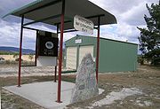
Remains of the Sandy Flat community comprises the remains of the former rail siding, a disused post office building and a modern Rural Fire Service shed together with an information stand. There are some scattered agricultural properties in the surrounding area.
Sports
Apart from facilities for the more traditional sports such as tennis, cricket and football the Sandy Flat Rifle Range provided many hours of recreation for men around the time of World War l. The 1,000 yard range was opened in 1913 with a telephone connection and a substantial weather shelter for its sixty or so members.Sandy Flat railway station
Further reading
Halliday, Ken, Call of the Highlands, Southern Cross Printery, Toowoomba, 1988Tenterfield Tourism, Tenterfield: A Federation Town, ICP Craftpress, Stanthorpe, QLD