
Tennyson Trail
Encyclopedia
The Tennyson Trail is a 15 mile walk from Carisbrooke Castle
to The Needles
on the Isle of Wight
. The route follows across Bowcombe Down, through Brighstone Forest
, across Mottistone Down, Brook Down & Afton Down
to Freshwater Bay
, then onto Tennyson Down
& across West High Down to Alum Bay
. The name of the trail comes from poet Alfred Lord Tennyson
, a former resident of the Isle of Wight.
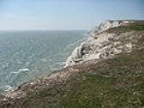
There are several points of interest along the walk, including The Tennyson Monument on Tennyson Down
, Farringford House
and The Needles Battery
which overlooks The Needles
.
The walk was completed on 25 May 2001. However in December 2002, the National Trust revealed that illegal 4x4 drivers and riders were destroying the paths, threatening the trail.
near Newport
. The sign for the Tennyson Trail is present on Nodgham Lane. After this, the trail follows a steep hill in a south-westerly direction along an ancient road with banks on each side. Views to the left show Carisbrooke Castle
, leading on to Bowcombe Valley. The route later crosses bridleways N125 and N127 and later passes N140 where a television mast is visible. At this point the path starts to descend before crossing a gate to a crossing track at the bottom. After crossing this, the route travels along Bridleway N136a to Brighstone Forest
to another gate around 80 metres further ahead. An overhead electrical cable will later pass overhead and will follow a narrow beech plantation to the left. After passing Bridleway N198 the trail continues straight ahead and uphill through open fields before leveling off at a gate which levels off and follows the sign for Bridleway N139 to Brook
and Freshwater
. As the track continues, it slowly becomes enclosed in trees through Brighstone Forest.
to the left and the Tennyson Trail to the right. Following this leads to Brighstone Down. The trail continues west along this track with sea views to the left before descending steadily to exit at a picnic area onto Lynch Lane. Turning right, then left will lead through the National Trust Jubilee Car Park and onto the National Trust information board. After passing the Forestry Commission Brighstone Forest entrance, the trail follows the down following the ancient road to the summit. After leaving National Trust land through a gate and continuing ahead on level ground, the path will immediately pass ancient burial mounds on the right. The track then descends to a further gate into a field where the Tennyson Trail is signposted. It will then descend through the field to reach the B3399 road to Freshwater and Yarmouth
to the right and Brook to the left.
. This track begins to immediately climb steeply passing a chalk pit on the right then bears right to avoid overhead electric cables. The trail continues ahead, steadily gaining height towards Afton Down. It then travels through the golf course on Afton Down with the track later descending to Freshwater Bay.
next to a block of public toilets on the lane to Fort Redoubt
. This lane then turns sharply left passing through two sets of stiles onto Tennyson Down
. From here the trail continues along the coastline, continuing to rise to the Tennyson Monument. After reaching the monument, the ground starts to descend. At the bottom of Tennyson Down will be a stile leading on to West High Down which has a steady incline until a radio aerial comes into view. After crossing a stile by the aerial, the trail then continues right onto a tarmac road. From here to the left, The Needles Battery
can be seen. The road passes a row of cottages where it turns sharply left. Here there is a stile with a descending path and another stile back onto the road. This road continues downwards to Alum Bay
, marking the end of the trail.
Carisbrooke Castle
Carisbrooke Castle is a historic motte-and-bailey castle located in the village of Carisbrooke, near Newport, Isle of Wight, England. Charles I was imprisoned at the castle in the months prior to his trial.-Early history:...
to The Needles
The Needles
The Needles is a row of three distinctive stacks of chalk that rise out of the sea off the western extremity of the Isle of Wight, England, close to Alum Bay. The Needles lighthouse stands at the end of the formation...
on the Isle of Wight
Isle of Wight
The Isle of Wight is a county and the largest island of England, located in the English Channel, on average about 2–4 miles off the south coast of the county of Hampshire, separated from the mainland by a strait called the Solent...
. The route follows across Bowcombe Down, through Brighstone Forest
Brighstone Forest
Brighstone Forest is located in the southwest of the Isle of Wight. It is the largest forest on the Isle of Wight, being just a few hectares larger than Parkhurst Forest. It is spread over a number of hilly ridges which form the backbone of the Isle of Wight. From west to east the ridges are...
, across Mottistone Down, Brook Down & Afton Down
Afton Down
Afton Down is a hill near the village of Freshwater on the Isle of Wight.It was the site of the Isle of Wight Festival 1970, where the Guinness Book of Records estimates 600,000 to 700,000, and possibly 800,000 people, flocked to see the musical talents of Emerson, Lake & Palmer, Free, The Who,...
to Freshwater Bay
Freshwater, Isle of Wight
Freshwater is a large village and civil parish at the western end of the Isle of Wight, England. Freshwater Bay is a small cove on the south coast of the Island which also gives its name to the nearby part of Freshwater....
, then onto Tennyson Down
Tennyson Down
Tennyson Down is a hill at the west end of the Isle of Wight just south of Totland. Tennyson Down is a grassy, whale-backed ridge of chalk which rises to 482 ft/147m above sea level. Tennyson Down is named after the poet Lord Tennyson who lived at nearby Farringdon House for nearly 40 years...
& across West High Down to Alum Bay
Alum Bay
Alum Bay is a bay near the westernmost point of the Isle of Wight, England, within sight of the Needles. Of geological interest and a tourist attraction, the bay is noted for its multi-coloured sand cliffs.-Geology:...
. The name of the trail comes from poet Alfred Lord Tennyson
Alfred Tennyson, 1st Baron Tennyson
Alfred Tennyson, 1st Baron Tennyson, FRS was Poet Laureate of the United Kingdom during much of Queen Victoria's reign and remains one of the most popular poets in the English language....
, a former resident of the Isle of Wight.
There are several points of interest along the walk, including The Tennyson Monument on Tennyson Down
Tennyson Down
Tennyson Down is a hill at the west end of the Isle of Wight just south of Totland. Tennyson Down is a grassy, whale-backed ridge of chalk which rises to 482 ft/147m above sea level. Tennyson Down is named after the poet Lord Tennyson who lived at nearby Farringdon House for nearly 40 years...
, Farringford House
Farringford House
Farringford House is a large manor house, with beautiful gardens, a large front garden where helicopters land, a restaurant called the 'Bistro' which has regular livebands and a previous Masterchef programme winner as a chef, outside swimming pool, tennis courts, holiday homes and a 9 hole golf...
and The Needles Battery
The Needles Battery
The Needles Battery was a military Battery built on the cliff top above the Needles stacks in 1861–63 to guard the West end of the Solent. Its field of fire was from approximately West South West clockwise to Northeast and it was designed to defend against enemy ships.-Old Battery:It was...
which overlooks The Needles
The Needles
The Needles is a row of three distinctive stacks of chalk that rise out of the sea off the western extremity of the Isle of Wight, England, close to Alum Bay. The Needles lighthouse stands at the end of the formation...
.
The walk was completed on 25 May 2001. However in December 2002, the National Trust revealed that illegal 4x4 drivers and riders were destroying the paths, threatening the trail.
The route
The route can be joined at any point, or walked in any direction however below it is described from Carisbrooke to Alum Bay.Carisbrooke to Brighstone
The route starts from CarisbrookeCarisbrooke
Carisbrooke is a village on the south western outskirts of Newport, Isle of Wight. It is best known as the site of Carisbrooke Castle. It also has a medieval parish church. St. Mary's Church , began life as part of a Benedictine priory, established by French monks about 1150...
near Newport
Newport, Isle of Wight
Newport is a civil parish and a county town of the Isle of Wight, an island off the south coast of England. Newport has a population of 23,957 according to the 2001 census...
. The sign for the Tennyson Trail is present on Nodgham Lane. After this, the trail follows a steep hill in a south-westerly direction along an ancient road with banks on each side. Views to the left show Carisbrooke Castle
Carisbrooke Castle
Carisbrooke Castle is a historic motte-and-bailey castle located in the village of Carisbrooke, near Newport, Isle of Wight, England. Charles I was imprisoned at the castle in the months prior to his trial.-Early history:...
, leading on to Bowcombe Valley. The route later crosses bridleways N125 and N127 and later passes N140 where a television mast is visible. At this point the path starts to descend before crossing a gate to a crossing track at the bottom. After crossing this, the route travels along Bridleway N136a to Brighstone Forest
Brighstone Forest
Brighstone Forest is located in the southwest of the Isle of Wight. It is the largest forest on the Isle of Wight, being just a few hectares larger than Parkhurst Forest. It is spread over a number of hilly ridges which form the backbone of the Isle of Wight. From west to east the ridges are...
to another gate around 80 metres further ahead. An overhead electrical cable will later pass overhead and will follow a narrow beech plantation to the left. After passing Bridleway N198 the trail continues straight ahead and uphill through open fields before leveling off at a gate which levels off and follows the sign for Bridleway N139 to Brook
Brook, Isle of Wight
-Background:It is situated on the south west coast of the Island between Brighstone and Freshwater, and borders a section of rugged coastline , the Back of the Wight, facing into the English Channel and towards the famous Needles and west Wight cliffs....
and Freshwater
Freshwater, Isle of Wight
Freshwater is a large village and civil parish at the western end of the Isle of Wight, England. Freshwater Bay is a small cove on the south coast of the Island which also gives its name to the nearby part of Freshwater....
. As the track continues, it slowly becomes enclosed in trees through Brighstone Forest.
Brighstone to Brook
On reaching Brighstone Forest, signs for the Tennyson Trail appear. After following these signs the track starts to descend and crosses Bridleway BS58 shortly before reaching a five-way crossing. After continuing straight at the crossing, a signpost appears showing the Worsley Trail and ShorwellShorwell
Shorwell is a village and civil parish on the Isle of Wight, United Kingdom. It is located six kilometres from Newport in the southwest of the island. Shorwell was one of Queen Victoria's favourite places to visit on the Isle of Wight.-History:...
to the left and the Tennyson Trail to the right. Following this leads to Brighstone Down. The trail continues west along this track with sea views to the left before descending steadily to exit at a picnic area onto Lynch Lane. Turning right, then left will lead through the National Trust Jubilee Car Park and onto the National Trust information board. After passing the Forestry Commission Brighstone Forest entrance, the trail follows the down following the ancient road to the summit. After leaving National Trust land through a gate and continuing ahead on level ground, the path will immediately pass ancient burial mounds on the right. The track then descends to a further gate into a field where the Tennyson Trail is signposted. It will then descend through the field to reach the B3399 road to Freshwater and Yarmouth
Yarmouth, Isle of Wight
Yarmouth is a port and civil parish in the western part of the Isle of Wight, off the southern coast of mainland England. The town is named for its location at the mouth of the small Western Yar river...
to the right and Brook to the left.
Brook to Freshwater
After turning right onto the road towards Freshwater, the path immediately restarts to the left by a bus stop and car park onto Compton DownCompton Down
Compton Down is a hill on the Isle of Wight just to the east of Freshwater Bay. It is part of the chalk ridge which forms the "backbone" of the Isle of Wight. It runs east to west, is approximately 3 miles long and is predominantly grass downland...
. This track begins to immediately climb steeply passing a chalk pit on the right then bears right to avoid overhead electric cables. The trail continues ahead, steadily gaining height towards Afton Down. It then travels through the golf course on Afton Down with the track later descending to Freshwater Bay.
Freshwater to Alum Bay
From here, the Tennyson Trail joins the westbound Coastal pathIsle of Wight Coastal Path
.There are a couple of cafes on the cliff path which I believe are open in the summer months. The only public convenience on the cliff path now appears to be closed permanently ....
next to a block of public toilets on the lane to Fort Redoubt
Freshwater Redoubt
Freshwater Redoubt, also known as Fort Redoubt is an old Palmerston fort built in Freshwater Bay on the western end of the Isle of Wight. Construction work for the fort began in 1855 and was completed in 1856. It was finally sold in 1928 and has now been converted into a private residence....
. This lane then turns sharply left passing through two sets of stiles onto Tennyson Down
Tennyson Down
Tennyson Down is a hill at the west end of the Isle of Wight just south of Totland. Tennyson Down is a grassy, whale-backed ridge of chalk which rises to 482 ft/147m above sea level. Tennyson Down is named after the poet Lord Tennyson who lived at nearby Farringdon House for nearly 40 years...
. From here the trail continues along the coastline, continuing to rise to the Tennyson Monument. After reaching the monument, the ground starts to descend. At the bottom of Tennyson Down will be a stile leading on to West High Down which has a steady incline until a radio aerial comes into view. After crossing a stile by the aerial, the trail then continues right onto a tarmac road. From here to the left, The Needles Battery
The Needles Battery
The Needles Battery was a military Battery built on the cliff top above the Needles stacks in 1861–63 to guard the West end of the Solent. Its field of fire was from approximately West South West clockwise to Northeast and it was designed to defend against enemy ships.-Old Battery:It was...
can be seen. The road passes a row of cottages where it turns sharply left. Here there is a stile with a descending path and another stile back onto the road. This road continues downwards to Alum Bay
Alum Bay
Alum Bay is a bay near the westernmost point of the Isle of Wight, England, within sight of the Needles. Of geological interest and a tourist attraction, the bay is noted for its multi-coloured sand cliffs.-Geology:...
, marking the end of the trail.