

Tenasserim Hills
Encyclopedia
Southeast Asia
Southeast Asia, South-East Asia, South East Asia or Southeastern Asia is a subregion of Asia, consisting of the countries that are geographically south of China, east of India, west of New Guinea and north of Australia. The region lies on the intersection of geological plates, with heavy seismic...
. Despite their relatively scant altitude these mountains form an effective barrier between Thailand
Thailand
Thailand , officially the Kingdom of Thailand , formerly known as Siam , is a country located at the centre of the Indochina peninsula and Southeast Asia. It is bordered to the north by Burma and Laos, to the east by Laos and Cambodia, to the south by the Gulf of Thailand and Malaysia, and to the...
and Burma in their northern and central region, extending to the Kra Isthmus
Kra Isthmus
The Kra Isthmus is the narrow land bridge which connects the Malay Peninsula with the mainland of Asia, and popularly named "The Devil's Neck".-Geography:...
into the Malay peninsula
Malay Peninsula
The Malay Peninsula or Thai-Malay Peninsula is a peninsula in Southeast Asia. The land mass runs approximately north-south and, at its terminus, is the southern-most point of the Asian mainland...
.
There are only two transnational roads and cross-border points between Chumphon
Chumphon
Chumphon is a town in southern Thailand, capital of the Chumphon Province and the Mueang Chumphon district. The city is located about 463 kilometers away from Bangkok...
and Tak
Tak (town)
Tak is a town in northwest of Thailand, capital of the Tak Province and the Tak district. As of 2005 the town has a population of 19,900 and an area of 7.27 km². It covers the tambon Rahaeng, Nong Luang, Chiang Ngoen and Hua Diat, and is located on the Ping River.-External links:*...
, at the Three Pagodas Pass
Three Pagodas Pass
The Three Pagodas Pass is a pass in the Tenasserim Hills on the border between Thailand and Burma , at an altitude of above sea level....
and at Mae Sot
Mae Sot
- External links :* * : an audio documentary.* *...
. The latter is located at the northern end of the range, where the Tenasserim Hills meet the Shan Hills
Shan Hills
The Shan Hills , also known as Shan Highland, are part of the range of hills that extends through Yunnan to Burma and Thailand, linking to the Himalayas, of which they may be considered foothills.-Etymology:...
.
Etymology
This mountain chain is named after Tenasserim (Tanintharyi) in Burma and its name in Thai is Thio Khao Tanaosi. According to Malaysian sources, the name may also be derived from the Kedah MalayMalay language
Malay is a major language of the Austronesian family. It is the official language of Malaysia , Indonesia , Brunei and Singapore...
name Tanah Sari or Tanah Seri which can be translated as "The essence land" or "The glowing land".
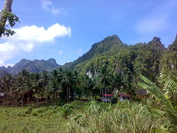
Geography
The Tenasserim Hills are part of a long graniteGranite
Granite is a common and widely occurring type of intrusive, felsic, igneous rock. Granite usually has a medium- to coarse-grained texture. Occasionally some individual crystals are larger than the groundmass, in which case the texture is known as porphyritic. A granitic rock with a porphyritic...
mountain ridge that is older than the Himalayas
Himalayas
The Himalaya Range or Himalaya Mountains Sanskrit: Devanagari: हिमालय, literally "abode of snow"), usually called the Himalayas or Himalaya for short, is a mountain range in Asia, separating the Indian subcontinent from the Tibetan Plateau...
.
Southwards from the 16th parallel, the Shan Hills
Shan Hills
The Shan Hills , also known as Shan Highland, are part of the range of hills that extends through Yunnan to Burma and Thailand, linking to the Himalayas, of which they may be considered foothills.-Etymology:...
break up into narrow steep-sided ranges that extend southwards along the Kra Isthmus. The westernmost range is separated from the Tenasserim coast by the Three Pagodas Fault. East of it lie the valleys of the Salween and the Gyaing.
Eastwards, on the Thai side, the mountain range is crossed by the Khwae Yai River
Khwae Yai River
The Khwae Yai River , also known as the Si Sawat , is a river in western Thailand. It flows for about 380 kilometres through Sangkhla Buri, Si Sawat, and Mueang Districts of Kanchanaburi Province, where it merges with the Khwae Noi to form the Mae Klong River at Pak Phraek subdistrict.The famous...
and the Khwae Noi River. In this area small hill ridges alternate with narrow valleys that are often only about 2 km wide and further east there are only isolated hills, where the range ends in the Central Plain of Thailand.
Sections
- Northern: The highest points in the northern section of the range are in the BilauktaungBilauktaungBilauktaung is a subrange of the Tenasserim Hills. It is located in Burma, very close to the border with Thailand. It extends for about 400 km from the Dawna Range along the border area to the Kra Isthmus....
subrange in Burma, Ngayannik Yuak Taung 1,531 m and Palan Taung 1,455 m, among other similarly high summits. The average elevations of the Tenasserim Hills are higher on the Burmese side, with many mountain peaks reaching 1,000 m, while on the Thai side the highest summits remain around 600 m. - Central: The southernmost extension of the Bilauktaung reaches the northern end of the Khra Isthmus. Further south the 1,780 m high Khao LuangKhao LuangKhao Luang is the tallest mountain in southern Thailand. It is located in Nakhon Sri Thammarat province.-Geography:The Khao Luang mountain is the highest summit of a massif of several hills with steep slopes...
(เขาหลวง), located in Nakhon Si Thammarat ProvinceNakhon Si Thammarat ProvinceNakhon Si Thammarat is one of the southern provinces of Thailand, at the eastern shore of the Gulf of Thailand...
, is the tallest mountain in Southern ThailandSouthern ThailandSouthern Thailand is a distinct region of Thailand, connected with the Central region by the narrow Kra Isthmus.-Geography:Southern Thailand is located on the Malay Peninsula, with an area around 70,713 km², bounded to the north by Kra Isthmus as the narrowest part of the peninsula. The...
. Some recent geographical works refer to the sections of the Tenasserim Hills in the isthmus as the "Phuket mountain rangePhuket mountain rangeThe Phuket mountain range is a mountain range in the Kra Isthmus, Thailand.-Geography:This chain of hills is one of the southern sections of the central cordillera, the mountain chain which runs from Tibet through all of the Malay peninsula....
", the "Nakhon Si Thammarat mountain rangeNakhon Si Thammarat mountain rangeThe Nakhon Si Thammarat mountain range is a mountain range on the Malay peninsula in southern Thailand, running in a north-south direction. This mountain chain is also sometimes named Banthat mountain range , a name which is however also used to refer to the Chanthaburi mountain...
" and the "Sankalakhiri mountain rangeSankalakhiri mountain rangeThe Sankalakhiri mountain range is the natural border between Thailand and Malaysia.This mountain range is a part of the Tenasserim Hills system...
". These names are not found, however, in classical geographic sources. - Southern: The Titiwangsa MountainsTitiwangsa MountainsThe Titiwangsa Mountains are the main mountain range that forms the backbone of the Malay Peninsula.-Geology:...
form the southern section of the mountain system. They are located in the Malay Highlands, in the state of Kota Bahru of Malaysia. The 2,183 m high Mount KorbuMount KorbuMount Korbu is a mountain in Perak, Malaysia. It is the highest peak of the Titiwangsa Mountains, the southernmost section of the Tenasserim Hills.Mt. Korbu is also the second highest mountain in Peninsular Malaysia, standing at 2,183 metres...
(Gunung Korbu) is the highest summit of this stretch.
Ecology
Great extensions of these hills are covered with forest. Usually the western slopes are more densely forested than the eastern for they receive more abundant monsoonMonsoon
Monsoon is traditionally defined as a seasonal reversing wind accompanied by corresponding changes in precipitation, but is now used to describe seasonal changes in atmospheric circulation and precipitation associated with the asymmetric heating of land and sea...
rains.
The Tenasserim Hills form the habitat for a number of endangered species, including the Asian Elephant
Asian Elephant
The Asian or Asiatic elephant is the only living species of the genus Elephas and distributed in Southeast Asia from India in the west to Borneo in the east. Three subspecies are recognized — Elephas maximus maximus from Sri Lanka, the Indian elephant or E. m. indicus from mainland Asia, and E. m....
and the Tiger
Tiger
The tiger is the largest cat species, reaching a total body length of up to and weighing up to . Their most recognizable feature is a pattern of dark vertical stripes on reddish-orange fur with lighter underparts...
. Other species include the Tenasserim White-bellied Rat
Tenasserim White-bellied Rat
The Tenasserim White-bellied Rat is a species of rodent in the family Muridae.It is named after the Tenasserim Hills and is found in India, Myanmar, and Vietnam.-References:...
and the Tenasserim lutung
Tenasserim Lutung
The Tenasserim lutung is a species of lutung. It is found in Myanmar and Thailand.It is named after the Tenasserim Hills....
. Among the fishes in the streams and rivulets of the range the Emperor loach and the Tenasserim Garra deserve mention.
History
This range forms a natural border between Burma and Thailand, but it was crossed in 1759 by Burmese troops led by AlaungpayaAlaungpaya
Alaungpaya was king of Burma from 1752 to 1760, and the founder of the Konbaung Dynasty. By his death in 1760, the former chief of a small village in Upper Burma had reunified all of Burma, subdued Manipur, recovered Lan Na, and driven out the French and the English who had given help to the...
and his son Hsinbyushin
Hsinbyushin
Hsinbyushin was king of the Konbaung dynasty of Burma from 1763 to 1776. The second son of the dynasty founder Alaungpaya is best known for his wars with China and Siam, and is considered the most militaristic king of the dynasty. His successful defense against four Chinese invasions preserved...
during the Burmese–Siamese War (1759–1760). The Burmese battle plan was to go around the heavily defended Siamese positions along shorter, more direct invasion routes. The invasion force overran relatively thin Siamese defenses in the coast, crossed the Tenasserim Hills to the shore of the Gulf of Siam, and turned north towards Ayutthaya.
In January 1942, at the beginning of the Japanese conquest of Burma, the main body of the Japanese 33d Division began the main attack towards Rangoon westward from Thailand across the Kawkareik
Kawkareik
Kawkareik is a town in the Kayin State of south Burma. It is the capital of Kawkareik District. The Kawkareik Pass across the Tenasserim Hills is named after this town....
Pass in the Tenasserim Range. A road was cut across the mountains by Japanese military engineers, but many infantry units crossed the range on foot in an arduous march through the forests and cliffs. This road was impracticable during the rainy season, when mud and rivulets made advance difficult for the Japanese and leech
Leech
Leeches are segmented worms that belong to the phylum Annelida and comprise the subclass Hirudinea. Like other oligochaetes such as earthworms, leeches share a clitellum and are hermaphrodites. Nevertheless, they differ from other oligochaetes in significant ways...
es abounded.
On the 19th July 2011 a Royal Thai Air Force
Royal Thai Air Force
The Royal Thai Air Force or RTAF is the air force of the Kingdom of Thailand. Since its establishment in 1913, as one of the earliest air forces of Asia, the Royal Thai Air Force had engaged in many major and minor battles. During the Vietnam war era, the air force has been developed with USAF-aid...
Sikorsky UH-60 Black Hawk
Sikorsky UH-60 Black Hawk
The UH-60 Black Hawk is a four-bladed, twin-engine, medium-lift utility helicopter manufactured by Sikorsky Aircraft. Sikorsky submitted the S-70 design for the United States Army's Utility Tactical Transport Aircraft System competition in 1972...
helicopter crashed in these mountains killing 9. The chopper had been sent out to recover five bodies of victims of another helicopter, a Bell UH-1 Iroquois, that had crashed two days before while looking for illegal loggers
Illegal logging
Illegal logging is the harvest, transportation, purchase or sale of timber in violation of laws. The harvesting procedure itself may be illegal, including using corrupt means to gain access to forests; extraction without permission or from a protected area; the cutting of protected species; or the...
in Kaeng Krachan National Park
Kaeng Krachan National Park
Kaeng Krachan is the largest national park of Thailand, located at the northern end of the Malay Peninsula. Due to its location near the tourist town of Hua Hin it is a popular park.-Geography:...
near the Burmese border west of Phetchaburi
Phetchaburi
Phetchaburi , also known as Phetburi, is a town in central Thailand, capital of the Phetchaburi Province. In Thai, Phetchaburi means city of diamonds . It is approximately 160km south of Bangkok, at the northern end of the Thai Peninsula...
. The Black Hawk helicopter crashed near 995 m high Yage Taung mountain in the Tanintharyi National Park in Burma, close to the border with Thailand.
A third helicopter, a Bell 212, also crashed in the same area on Sunday 25th July a few miles further east close to the Kaeng Krachan reservoir. Superstitious people blamed the three consecutive crashes on the fact that the densely forested mountains of the Tenasserim Range have strong guardian spirits.