
Tenango del Aire
Encyclopedia
Tenango del Aire is a town and municipality
located in the southeast portion of the State of Mexico and is about 42 km southeast of Mexico City
. The municipality is bordered by Temamatla
, Tlalmanalco
, Juchitepec
, and Ayapango
, Despite the fact that this municipality is distinctly rural, it falls within the Mexico City Metropolitan Area
. The name “Tenango del Aire” came about in two parts. Originally and until 1890, the town was known as Tenango de Topopula. “Tenango” means “walled in” or “fenced by stones.” The second part is due to visits by President Porfirio Diaz
, who commented on the winds that are prevalent here. “del Aire” means “of the air.”
s called the Teotenancas (Old Tenancas), entered the Valley of Chalco, conquering nearby Amecameca 100 years later. The first settlement in this part of the valley was in what is now San Mateo Tepopula, which is near the town. The Spaniards passed by here
on their way to Tenochtitlan.
 Soon after, in 1521, a number of Tenancas (descendents of the Teotenacas) moved to where the town is now, calling it “Tenanco.” In 1532, Juan de Zumárraga
, the first Archbishop of Mexico, ordered the construction of the parish church, called San Juan Bautista (John the Baptist
), and called the village here San Juan Tepopula. This term today is used to designate one of the neighborhoods of the town. Eventually, the official name was Tenango de San Juan Bautista Tepopula, then Tenango Tepopula, until the official name changed to what it is now.
Tenango del Aire gained municipality status in 1820, and the current municipal palace was built in 1978. As of the 2010 census, the town had a population of 5,915 people.
dates to the 18th century and has a baptismal with reliefs of the Archangel Michael and an inscription that dates it to the year 1710. It contains a sculpture of Our Lady of the Rosary
and paintings that depicts souls burning in Hell
, both of which date to the 17th century.
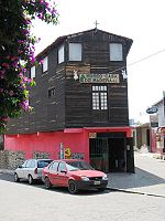 The Casa de Madera Museum is a private museum which exhibits the second most important collection of applied arts in Mexico after the Franz Mayer Museum
, according to CONACULTA. The museum’s collection is spread out over four buildings with no apparent order and no other infrastructure other than the collection itself. The collection includes thousands of pieces from pre-Hispanic artifacts, religious art from the colonial period, and even modern art by known names, but the majority of the collection is everyday items from the last three centuries.
The Casa de Madera has been likened to visiting a grandparents’ attic. There are portraits from the 1920’s, barbers’ implements, kitchens and living rooms packed with old furniture and decorations, old toys, watches, telephones, jars, farming implements, musical instruments and more. There is even a pen capable of shooting a 22 caliber bullet from World War II. The owners, Luis Pastor and Ricardo Flores, have been amassing the collection since the 1970s. The buildings in which the objects are stored are private houses, some areas of which the family still lives. Visitors to the museum are guided by the owners and their family who chat about the pieces as they stroll past. The tour takes about two hours. The museum has received grants from the Fondo Nacional para la Cultura y las Artes and has been open to the public since 1995.
A sports complex was opened here in 2006, with two multipurpose gyms, two jai alai
courts, a soccer field, a playground for children and walking paths.
in the State of Morelos
).
Lying in a region of old lakebeds and ash from the nearby volcano of Popocatepetl
, the land here is fertile. The highest elevation is the Tezoyuca Mountain with other notable elevations such as Cuajoma, Zoceyuca and Xaltepec Mountains. These and others cover about 40% of the municipality’s territory. There is one river here called the Apotzonalco, but it only flows during the rainy season as do a number of arroyos. However, there are a number of underground water resources, which supply the municipality with potable water.
Most of the residents of the municipality earn a living through farming and/or livestock raising, producing corn, cattle and domestic fowl. Some fruit, principally capulin
s, tejocotes, and peaches are grown. About two-thirds of this is for local consumption. There is little industry and commerce here. What is here is limited to the needs of the farming community.
About six kilometers north of the municipal seat is the Chucoatl Ceremonial Center, which is located on an ejido. It is an archeological site with petroglyph
s, a stone serpent’s head and an etched hydraulic map. The serpent’s head is placed such that, at the solstice, the sun rising over the “neck” of the Iztaccíhuatl
volcano (which resembles a sleeping woman) shines its first rays of light on it. It is thought to have significance with the fertility of the land. Another pre-Hispanic complex is located by the Cuajoma Mountain. The sites have several layers. Some date from the fall of Teotihuacan in 1600 AD to the occupation of the area by Chichimeca tribes in the 13th and 14th centuries. Artifacts found at the surface date from 1400 to 1521 AD.
There is a research site dedicated to investigating atmospheric conditions, in particular the effects of air pollution in nearby Mexico City. It is the only center located to collect data from times when the wind blows south away from the city. In particular, nitric oxide
levels are measured here.
Municipality
A municipality is essentially an urban administrative division having corporate status and usually powers of self-government. It can also be used to mean the governing body of a municipality. A municipality is a general-purpose administrative subdivision, as opposed to a special-purpose district...
located in the southeast portion of the State of Mexico and is about 42 km southeast of Mexico City
Mexico City
Mexico City is the Federal District , capital of Mexico and seat of the federal powers of the Mexican Union. It is a federal entity within Mexico which is not part of any one of the 31 Mexican states but belongs to the federation as a whole...
. The municipality is bordered by Temamatla
Temamatla
Temamatla is a town and municipality in Mexico State in Mexico. The municipality covers an area of 28.42 km².As of 2005, the municipality had a total population of 10,135....
, Tlalmanalco
Tlalmanalco
Tlalmanalco is a town and municipality located in the far south-eastern part of the State of Mexico. The name is from the Nahuatl language, meaning “flat area.” The municipality’s seal shows flat land, with a pyramid on it, representing its pre-Hispanic history, surrounded by small mountains, which...
, Juchitepec
Juchitepec
Juchitepec is a town and municipality in Mexico State in central Mexico. Juchitepec means “Hill of the Flowers” in Nahuatl. The municipality covers an area of 149.56 km². It has one major community outside of the seat called San Matias Cuijingo...
, and Ayapango
Ayapango
Ayapango is a small town and municipality located in the southeast portion of the State of Mexico, southeast of Mexico City. Despite the fact that this municipality is distinctly rural, it falls within the Mexico City Metropolitan Area...
, Despite the fact that this municipality is distinctly rural, it falls within the Mexico City Metropolitan Area
Greater Mexico City
Greater Mexico City refers to the conurbation around Mexico City, officially called Mexico City Metropolitan Area , constituted by the Federal District—itself composed of 16 boroughs—and 41 adjacent municipalities of the states of Mexico and Hidalgo...
. The name “Tenango del Aire” came about in two parts. Originally and until 1890, the town was known as Tenango de Topopula. “Tenango” means “walled in” or “fenced by stones.” The second part is due to visits by President Porfirio Diaz
Porfirio Díaz
José de la Cruz Porfirio Díaz Mori was a Mexican-American War volunteer and French intervention hero, an accomplished general and the President of Mexico continuously from 1876 to 1911, with the exception of a brief term in 1876 when he left Juan N...
, who commented on the winds that are prevalent here. “del Aire” means “of the air.”
History
In 1162, a subgroup of ChichimecaChichimeca
Chichimeca was the name that the Nahua peoples of Mexico generically applied to a wide range of semi-nomadic peoples who inhabited the north of modern-day Mexico and southwestern United States, and carried the same sense as the European term "barbarian"...
s called the Teotenancas (Old Tenancas), entered the Valley of Chalco, conquering nearby Amecameca 100 years later. The first settlement in this part of the valley was in what is now San Mateo Tepopula, which is near the town. The Spaniards passed by here
Spanish conquest of Mexico
The Spanish conquest of the Aztec Empire was one of the most important campaigns in the Spanish colonization of the Americas. The invasion began in February 1519 and was acclaimed victorious on August 13, 1521, by a coalition army of Spanish conquistadors and Tlaxcalan warriors led by Hernán Cortés...
on their way to Tenochtitlan.
Juan de Zumárraga
Juan de Zumárraga was a Spanish Basque Franciscan prelate and first bishop of Mexico.-Origins and arrival in New Spain:...
, the first Archbishop of Mexico, ordered the construction of the parish church, called San Juan Bautista (John the Baptist
John the Baptist
John the Baptist was an itinerant preacher and a major religious figure mentioned in the Canonical gospels. He is described in the Gospel of Luke as a relative of Jesus, who led a movement of baptism at the Jordan River...
), and called the village here San Juan Tepopula. This term today is used to designate one of the neighborhoods of the town. Eventually, the official name was Tenango de San Juan Bautista Tepopula, then Tenango Tepopula, until the official name changed to what it is now.
Tenango del Aire gained municipality status in 1820, and the current municipal palace was built in 1978. As of the 2010 census, the town had a population of 5,915 people.
Notable sites
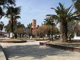
The San Juan Bautista Parish and plaza was ordered in 1532 and completed in 1671, initially run by the Franciscans. The baptisteryBaptistery
In Christian architecture the baptistry or baptistery is the separate centrally-planned structure surrounding the baptismal font. The baptistry may be incorporated within the body of a church or cathedral and be provided with an altar as a chapel...
dates to the 18th century and has a baptismal with reliefs of the Archangel Michael and an inscription that dates it to the year 1710. It contains a sculpture of Our Lady of the Rosary
Our Lady of the Rosary
Our Lady of the Rosary is a title of the Blessed Virgin Mary in relation to the rosary....
and paintings that depicts souls burning in Hell
Hell
In many religious traditions, a hell is a place of suffering and punishment in the afterlife. Religions with a linear divine history often depict hells as endless. Religions with a cyclic history often depict a hell as an intermediary period between incarnations...
, both of which date to the 17th century.
Franz Mayer Museum
The Franz Mayer Museum , in Mexico City opened in 1986 to house, display and maintain Latin America’s largest collection of decorative arts. The collection was amassed by stockbroker and financial professional Franz Mayer, who collected fine artworks, books, furniture, ceramics, textiles and many...
, according to CONACULTA. The museum’s collection is spread out over four buildings with no apparent order and no other infrastructure other than the collection itself. The collection includes thousands of pieces from pre-Hispanic artifacts, religious art from the colonial period, and even modern art by known names, but the majority of the collection is everyday items from the last three centuries.
The Casa de Madera has been likened to visiting a grandparents’ attic. There are portraits from the 1920’s, barbers’ implements, kitchens and living rooms packed with old furniture and decorations, old toys, watches, telephones, jars, farming implements, musical instruments and more. There is even a pen capable of shooting a 22 caliber bullet from World War II. The owners, Luis Pastor and Ricardo Flores, have been amassing the collection since the 1970s. The buildings in which the objects are stored are private houses, some areas of which the family still lives. Visitors to the museum are guided by the owners and their family who chat about the pieces as they stroll past. The tour takes about two hours. The museum has received grants from the Fondo Nacional para la Cultura y las Artes and has been open to the public since 1995.
A sports complex was opened here in 2006, with two multipurpose gyms, two jai alai
Jai alai
Jai alai is a sport involving a ball bounced off a walled space. It is a variety of Basque Pelota. The term, coined by Serafin Baroja in 1875, is also often loosely applied to the fronton where the sport is played...
courts, a soccer field, a playground for children and walking paths.
The municipality
As municipal seat the town of Tenango del Aire is the governing authority for the following communities: San Juan Coxtocan, Santiago Tepopula, Rancho Aculco (El Paraíso), San Luis Aculco, Tecuatitla (Colonia Nueva Tecuatitla), Rancho el Paredón, Cerro de las Campanas, Rutilo Herrera, El Pedregal (Teotoxtipan), Rancho Chavarría (Paraje Puerta), Tecorral, Tlatelpa, Rancho San Isidro Labrador (El Piaje), Rancho Saturnino (Tepalcapa), Tres Platos, La Casa del Puente, Colonia el Mirador and Barrio San Miguel (Las Espinas). The municipality has a territory of 38.09 km2. and a total population of 10,578 inhabitants at the 2010 census. It is the second-least populous municipality that borders Mexico City (the Distrito Federal) directly (following Tlalnepantla MunicipalityTlalnepantla, Morelos
Tlalnepantla is a city in the Mexican state of Morelos.It stands at .The city serves as the municipal seat for the surrounding municipality, with which it shares a name....
in the State of Morelos
Morelos
Morelos officially Estado Libre y Soberano de Morelos is one of the 31 states which, with the Federal District, comprise the 32 Federal Entities of Mexico. It is divided in 33 municipalities and its capital city is Cuernavaca....
).
Lying in a region of old lakebeds and ash from the nearby volcano of Popocatepetl
Popocatépetl
Popocatépetl also known as "Popochowa" by the local population is an active volcano and, at , the second highest peak in Mexico after the Pico de Orizaba...
, the land here is fertile. The highest elevation is the Tezoyuca Mountain with other notable elevations such as Cuajoma, Zoceyuca and Xaltepec Mountains. These and others cover about 40% of the municipality’s territory. There is one river here called the Apotzonalco, but it only flows during the rainy season as do a number of arroyos. However, there are a number of underground water resources, which supply the municipality with potable water.
Most of the residents of the municipality earn a living through farming and/or livestock raising, producing corn, cattle and domestic fowl. Some fruit, principally capulin
Capulin
Prunus salicifolia , known as Capulin, is a species of cherry. It is similar to the Jamaica cherry. The capulin is often called the capuli, capoli, capulin, or capolin in both Mexico and Colombia...
s, tejocotes, and peaches are grown. About two-thirds of this is for local consumption. There is little industry and commerce here. What is here is limited to the needs of the farming community.
About six kilometers north of the municipal seat is the Chucoatl Ceremonial Center, which is located on an ejido. It is an archeological site with petroglyph
Petroglyph
Petroglyphs are pictogram and logogram images created by removing part of a rock surface by incising, picking, carving, and abrading. Outside North America, scholars often use terms such as "carving", "engraving", or other descriptions of the technique to refer to such images...
s, a stone serpent’s head and an etched hydraulic map. The serpent’s head is placed such that, at the solstice, the sun rising over the “neck” of the Iztaccíhuatl
Iztaccíhuatl
Iztaccíhuatl , is the third highest mountain in Mexico, after the Pico de Orizaba, , and Popocatépetl, . Its name is Nahuatl for "White woman"....
volcano (which resembles a sleeping woman) shines its first rays of light on it. It is thought to have significance with the fertility of the land. Another pre-Hispanic complex is located by the Cuajoma Mountain. The sites have several layers. Some date from the fall of Teotihuacan in 1600 AD to the occupation of the area by Chichimeca tribes in the 13th and 14th centuries. Artifacts found at the surface date from 1400 to 1521 AD.
There is a research site dedicated to investigating atmospheric conditions, in particular the effects of air pollution in nearby Mexico City. It is the only center located to collect data from times when the wind blows south away from the city. In particular, nitric oxide
Nitric oxide
Nitric oxide, also known as nitrogen monoxide, is a diatomic molecule with chemical formula NO. It is a free radical and is an important intermediate in the chemical industry...
levels are measured here.
Towns and villages
The largest localities (cities, towns, and villages) are:| Name | 2010 Census Population |
|---|---|
| Tenango del Aire Tenango del Aire Tenango del Aire is a town and municipality located in the southeast portion of the State of Mexico and is about 42 km southeast of Mexico City. The municipality is bordered by Temamatla, Tlalmanalco, Juchitepec, and Ayapango, Despite the fact that this municipality is distinctly rural, it... |
5,915 |
| Santiago Tepopula | 2,418 |
| San Juan Coxtocan | 1,810 |
| Tecuatitla (Colonia Nueva Tecuatitla) | 135 |
| Barrio San Miguel (Las Espinas) | 70 |
| Total Municipality | 10,578 |