
Georgia State Route 56
Encyclopedia
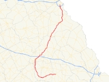
State Route 56 is a north–south state route located in the eastern part of the U.S. state
of Georgia
. The route travels from U.S. Route 280
/State Route 30 in Reidsville
to U.S. Route 25
/State Route 121 in Augusta
.
, to Uvalda
. In Uvalda, State Route 56 becomes cosigned
with U.S. Route 221
, and the two routes travel north to Mount Vernon
, where they intersect U.S. Route 280/State Route 30. After leaving Mount Vernon, U.S. Route 221 and State Route 56 travel north to Soperton
, then turn to the northeast. Shortly after intersecting Interstate 16
, State Route 56 departs U.S. Route 221 and travels northeast to Swainsboro
. After brief cosignages with U.S. Route 1
and U.S. Route 80
, State Route 56 continues north-northeast to Waynesboro
. After short cosignages with State Route 24
and State Route 80, and an intersection with U.S. Route 25/State Route 121, State Route 56 travels north into Augusta. After intersecting Interstate 520
, the route meets its northern terminus at U.S. Route 25/State Route 121.
State Route 56, being mostly in a rural area, sees an Average Annual Daily Traffic of 5,000 vehicles or less over much of the route. However, the route sees an AADT of 14,300 vehicles near its northern terminus in Augusta.
The southern instance is in Burke County
, and runs east from the State Route 56 mainline near McBean to the eastern terminus of State Route 80.
The northern instance is in Richmond County
, and runs north from the State Route 56 mainline, intersecting Interstate 520, to U.S. Route 25/U.S. Route 78
/U.S. Route 278
/State Route 10/State Route 121 in Augusta.
U.S. state
A U.S. state is any one of the 50 federated states of the United States of America that share sovereignty with the federal government. Because of this shared sovereignty, an American is a citizen both of the federal entity and of his or her state of domicile. Four states use the official title of...
of Georgia
Georgia (U.S. state)
Georgia is a state located in the southeastern United States. It was established in 1732, the last of the original Thirteen Colonies. The state is named after King George II of Great Britain. Georgia was the fourth state to ratify the United States Constitution, on January 2, 1788...
. The route travels from U.S. Route 280
U.S. Route 280
U.S. Route 280 is a spur of U.S. Highway 80. It currently runs for 392 miles from Blichton, Georgia at U.S. Highway 80 to Birmingham, Alabama at I-20/I-59. For much of its route, U.S. 280 travels through rural areas and smaller cities in southern Georgia and east central Alabama. Once the...
/State Route 30 in Reidsville
Reidsville, Georgia
Reidsville is a city in Tattnall County, Georgia, United States. The population was 2,235 at the 2000 census. The city is the county seat of Tattnall County...
to U.S. Route 25
U.S. Route 25
U.S. Route 25 is a north–south United States highway that runs for from Brunswick, Georgia to the Ohio state line in Covington, Kentucky.-Georgia:...
/State Route 121 in Augusta
Augusta, Georgia
Augusta is a consolidated city in the U.S. state of Georgia, located along the Savannah River. As of the 2010 census, the Augusta–Richmond County population was 195,844 not counting the unconsolidated cities of Hephzibah and Blythe.Augusta is the principal city of the Augusta-Richmond County...
.
Route description
From its southern terminus at U.S. 280/State Route 30 in Reidsville, State Route 56 travels west, running parallel to the Altamaha RiverAltamaha River
The Altamaha River is a major river of the American state of Georgia. It flows generally eastward for 137 miles from its origin at the confluence of the Oconee River and Ocmulgee River towards the Atlantic Ocean, where it empties into the ocean near Brunswick, Georgia. There are no dams...
, to Uvalda
Uvalda, Georgia
Uvalda is a city in Montgomery County, Georgia, United States. The population was 530 at the 2000 census. It is part of the Vidalia Micropolitan Statistical Area.-Geography:Uvalda is located at ....
. In Uvalda, State Route 56 becomes cosigned
Concurrency (road)
A concurrency, overlap, or coincidence in a road network is an instance of one physical road bearing two or more different highway, motorway, or other route numbers...
with U.S. Route 221
U.S. Route 221
U.S. Route 221 is a spur of U.S. Route 21. It runs for 734 miles from Perry, Florida at US Routes 19/98/ALT 27 to Lynchburg, Virginia at U.S. Route 29 . It passes through the states of Florida, Georgia, South Carolina, North Carolina, and Virginia...
, and the two routes travel north to Mount Vernon
Mount Vernon, Georgia
Mount Vernon is a city in Montgomery County, Georgia, United States. The population was 2,082 at the 2000 census. It is home to the Baptist-affiliated Brewton-Parker College.Mount Vernon is part of the Vidalia Micropolitan Statistical Area.-Geography:...
, where they intersect U.S. Route 280/State Route 30. After leaving Mount Vernon, U.S. Route 221 and State Route 56 travel north to Soperton
Soperton, Georgia
Soperton is a city in Treutlen County, Georgia, United States. The population was 2,824 at the 2000 census. The city is the county seat of Treutlen County.-Geography:Soperton is located at ....
, then turn to the northeast. Shortly after intersecting Interstate 16
Interstate 16
Interstate 16 , also known as Jim Gillis Historic Savannah Parkway or State Route 404 , is an intrastate Interstate Highway located entirely within the state of Georgia, United States...
, State Route 56 departs U.S. Route 221 and travels northeast to Swainsboro
Swainsboro, Georgia
Swainsboro is a city located in Emanuel County, Georgia. As of the 2000 census, the city had a total population of 6,943. The city is the county seat of Emanuel County.-Geography:...
. After brief cosignages with U.S. Route 1
U.S. Route 1
U.S. Route 1 is a major north–south U.S. Highway that serves the East Coast of the United States. It runs 2,377 miles from Fort Kent, Maine at the Canadian border south to Key West, Florida. U.S. 1 generally parallels Interstate 95, though it is significantly farther west between...
and U.S. Route 80
U.S. Route 80
U.S. Route 80 is an east–west United States highway, much of which was once part of the early auto trail known as the Dixie Overland Highway. As the "0" in the route number indicates, it was originally a cross-country route, from the Atlantic to the Pacific...
, State Route 56 continues north-northeast to Waynesboro
Waynesboro, Georgia
Waynesboro is a city in Burke County, Georgia, United States. The population was 5,813 at the 2000 census. The city is the county seat of Burke County...
. After short cosignages with State Route 24
State Route 24 (Georgia)
State Route 24 is a state highway in the U.S. state of Georgia. It runs from State Route 15 north of Watkinsville south to Milledgeville along U.S. Highway 441, east to Waynesboro, and southeast and southwest to end at State Route 26/U.S. Highway 80 in Statesboro.Initially SR 24 ran from...
and State Route 80, and an intersection with U.S. Route 25/State Route 121, State Route 56 travels north into Augusta. After intersecting Interstate 520
Interstate 520
Interstate 520 is a auxiliary Interstate Highway that encircles Augusta, Georgia and North Augusta, South Carolina as a three quarter beltway around the western, southern and eastern parts of the Augusta area. It begins at Interstate 20 in the northwest part of Augusta, and ends at Interstate 20...
, the route meets its northern terminus at U.S. Route 25/State Route 121.
State Route 56, being mostly in a rural area, sees an Average Annual Daily Traffic of 5,000 vehicles or less over much of the route. However, the route sees an AADT of 14,300 vehicles near its northern terminus in Augusta.
Banner Routes
State Route 56 has two banner routes, both of which are signed Georgia State Route 56 Spur.The southern instance is in Burke County
Burke County, Georgia
Burke County is a county located in the U.S. state of Georgia. As of 2000, the population was 22,243. The 2007 Census Estimate showed a population of 22,754...
, and runs east from the State Route 56 mainline near McBean to the eastern terminus of State Route 80.
The northern instance is in Richmond County
Richmond County, Georgia
Richmond County is a county located in the U.S. state of Georgia. It is one of the original counties of Georgia, created February 5, 1777. As of 2010, the population was 200,549. The 2007 Census Estimate showed a population of 199,486....
, and runs north from the State Route 56 mainline, intersecting Interstate 520, to U.S. Route 25/U.S. Route 78
U.S. Route 78
U.S. Highway 78 is an east–west United States highway that runs for 715 miles from Memphis, Tennessee, to Charleston, South Carolina. Between Memphis and Birmingham, Alabama, it is being upgraded to become Interstate 22....
/U.S. Route 278
U.S. Route 278
U.S. Route 278 is a parallel route of U.S. Route 78. It currently runs for 1,074 miles from Hilton Head Island, South Carolina to Wickes, Arkansas at U.S. Highway 71/U.S. Highway 59. It might be notable that it is longer than its parent highway, US Hwy-78. US Hwy-278 passes through the states of...
/State Route 10/State Route 121 in Augusta.