
Tasmania Parks and Wildlife Service
Encyclopedia
Tasmania Parks and Wildlife Service is the Tasmanian Government body responsible for the care and administration of Tasmania's National Parks and wildlife.
and the unsuccessful attempts to prevent the project going ahead. A Select Committee formed from the interested parties recommended the establishment of a professional park service to properly manage the natural environment in Tasmania. The service initially had a staff of 59. The National Parks and Wildlife Act 1970 had made provisions for the conservation of fauna and flora and the establishment and management of national parks. Mount William
, Maria Island
and Narawntapu
National Parks were set up and Macquarie Island
designated as a nature reserve.
 The creation of an Archaeology Section within the service followed the 1975 Aboriginal Relics Act. In the following year Precipitous Bluff was incorporated into the Southwest National Park
. Controversy in 1979 over the proposed Lower Gordon hydro-electric power scheme, which would have meant flooding the Franklin River
led to the creation of the Franklin-Lower Gordon Wild Rivers National Park in 1981 (construction of the dam was stopped by a court ruling in 1983.
In 1987 the service was merged with the Department of Lands to form the Department of Lands, Parks and Wildlife and relocated to new premises.
In 1989 the Department of Lands, Parks and Wildlife became the Department of Environment and Planning and Department of Parks, Wildlife and Heritage, managing Crown land as well as the reserves, and with duties to conserve wildlife and historic heritage sites. The Royal Tasmanian Botanical Gardens
and the Port Arthur Historic Site Management Authority
also became part of the Department.
In the same year the Douglas-Apsley National Park, important for its dry sclerophyll
forests, was established in the east of the state. The Tasmanian Wilderness World Heritage Area
was expanded to include the Central Plateau Conservation Area
. With other additions the World Heritage Area
increased to 13,800 km² (approximately 20% of Tasmania).
In 1990, Tasmania's first marine reserves were established at Maria Island
, Governor Island, Tinderbox and Ninepins Point.
On February 3, 1993, the Department once again merged, this time with the Department of Environment and Land Management (DELM), with The Parks and Wildlife Service functioning as a separate division within the department. In 1993 the introduction of park fees allowed the service to fund projects aimed at visitors including visitor centres and official trails.
Some land previously managed by the service was transferred to Aboriginal Land Council of Tasmania and an Aboriginal Heritage Unit was created to provide training for Aboriginal community members, to allow them to advise on Aboriginal heritage management.
In 1996 the Mole Creek Karst National Park
was created and South Bruny National Park
followed in October 1997.
 Under the Regional Forestry Agreement (RFA) an extra 3,960 km² of public land were added to Tasmania's reserves, expanding the amount of public land in reserves by 17%. The RFA also expanded Mount William National Park, Freycinet National Park
and created Tasman
and Savage River
National Parks. Offsetting these gains were 700 km² of reserves which were made available for forestry development.
A further departmental merger occurred after the 1998 elections with an amalgamation into the Department of Primary Industries and Fisheries and the Government Analytical and Forensic Laboratories (GAFL) creating the Department of Primary Industries, Water and Environment (DPIWE).
The Parks and Wildlife Service was split into two separate divisions: the Resource Management and Conservation Division had responsibility for the natural and cultural resources and the Parks and Wildlife Service covered Tasmania's parks, reserves and World Heritage Areas. The Parks and Wildlife Service was separated from the Department of Primary Industries, Water and Environment following the 2002 State elections, becoming part of the Department of Tourism, Parks, Heritage and the Arts (DTPHA), while the Resource Management and Conservation Division remained part of the DPIWE.
In 2002 three islands, Deal, Erith and Dover were declared as part of the Kent Group National Park and marine protected areas were created there and at Port Davey-Bathurst Harbour
.
In April 2006 the Department incorporated the Environment Division from Department of Primary Industries, Water and Environment. This led to a renaming of the Department to the Department of Tourism, Arts and the Environment (DTAE).
In 2007 the Tasmanian Coast Conservation Fund
was established. Tour company operator Robert Pennicott founder of Bruny Island Cruises and Tasman Island Cruises came together with environmental group WILDCARE to establish the fund. While operating separately to the Tasmanian Parks and Wildlife Service, the fund is used to provide funding to the Parks and Wildlife Service to assist environmental protection and conservation projects in Tasmania's National Parks.
History
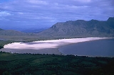
The National Parks and Wildlife Service was set up on November 1, 1971 after controversy surrounding the proposal to flood Lake PedderLake Pedder
Lake Pedder was once a natural lake, located in the southwest of Tasmania, Australia but the name is now used in an official sense to refer to the much larger artificial impoundment and diversion lake formed when the original lake was expanded by damming in 1972 by the Hydro Electric Commission of...
and the unsuccessful attempts to prevent the project going ahead. A Select Committee formed from the interested parties recommended the establishment of a professional park service to properly manage the natural environment in Tasmania. The service initially had a staff of 59. The National Parks and Wildlife Act 1970 had made provisions for the conservation of fauna and flora and the establishment and management of national parks. Mount William
Mount William National Park
Mount William is a national park in Tasmania , 234 km northeast of Hobart....
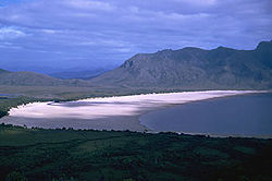
, Maria Island
Maria Island
Maria Island is a mountainous island off the east coast of Tasmania. The entire island is a national park. Maria Island National Park has a total area of 115.50 km², which includes a marine area of 18.78 km² off the island's northwest coast. The island is about 20 km in length from...
and Narawntapu
Narawntapu National Park
Narawntapu is a national park in Tasmania, Australia. It lies on Tasmania's north coast, adjoining Bass Strait, between Port Sorell in the west and the mouth of the Tamar River in the east...
National Parks were set up and Macquarie Island
Macquarie Island
Macquarie Island lies in the southwest corner of the Pacific Ocean, about half-way between New Zealand and Antarctica, at 54°30S, 158°57E. Politically, it has formed part of the Australian state of Tasmania since 1900 and became a Tasmanian State Reserve in 1978. In 1997 it became a world heritage...
designated as a nature reserve.
Southwest National Park
The Southwest National Park is a national park located in the south-west of Tasmania, Australia. The park is Tasmania's largest and forms part of the Tasmanian Wilderness World Heritage Area....
. Controversy in 1979 over the proposed Lower Gordon hydro-electric power scheme, which would have meant flooding the Franklin River
Franklin River
The Franklin River lies in the Franklin-Gordon Wild Rivers National Park at the mid northern area of the Tasmanian Wilderness World Heritage Area. Its source is situated at the western edge of the Central Highlands and it continues west towards the West Coast of Tasmania...
led to the creation of the Franklin-Lower Gordon Wild Rivers National Park in 1981 (construction of the dam was stopped by a court ruling in 1983.
In 1987 the service was merged with the Department of Lands to form the Department of Lands, Parks and Wildlife and relocated to new premises.
In 1989 the Department of Lands, Parks and Wildlife became the Department of Environment and Planning and Department of Parks, Wildlife and Heritage, managing Crown land as well as the reserves, and with duties to conserve wildlife and historic heritage sites. The Royal Tasmanian Botanical Gardens
Royal Tasmanian Botanical Gardens
The Royal Tasmanian Botanical Gardens, which cover an area of approximately 14 hectares , were established in Hobart in 1818 and are located within the Queens Domain. The Gardens hold historic plant collections and a large number of significant trees, many dating back to the nineteenth century...
and the Port Arthur Historic Site Management Authority
Port Arthur, Tasmania
Port Arthur is a small town and former convict settlement on the Tasman Peninsula, in Tasmania, Australia. Port Arthur is one of Australia's most significant heritage areas and the open air museum is officially Tasmania's top tourist attraction. It is located approximately 60 km south east of...
also became part of the Department.
In the same year the Douglas-Apsley National Park, important for its dry sclerophyll
Sclerophyll
Sclerophyll is the term for a type of vegetation that has hard leaves and short internodes . The word comes from the Greek sclero and phyllon ....
forests, was established in the east of the state. The Tasmanian Wilderness World Heritage Area
Tasmanian Wilderness
The Tasmanian Wilderness is a term that is used for a range of areas in Tasmania, Australia.The World Heritage Areas in South West, Western and Central are the most well known. However, there are also other areas in Tasmania that have the elements of being known as wilderness areas, the Tarkine...
was expanded to include the Central Plateau Conservation Area
Central Plateau Conservation Area
The Central Plateau conservation area is an animal & plant conservation area in Tasmania, Australia.The Central Plateau of Tasmania is the largest area of high ground in Tasmania...
. With other additions the World Heritage Area
World Heritage Site
A UNESCO World Heritage Site is a place that is listed by the UNESCO as of special cultural or physical significance...
increased to 13,800 km² (approximately 20% of Tasmania).
In 1990, Tasmania's first marine reserves were established at Maria Island
Maria Island
Maria Island is a mountainous island off the east coast of Tasmania. The entire island is a national park. Maria Island National Park has a total area of 115.50 km², which includes a marine area of 18.78 km² off the island's northwest coast. The island is about 20 km in length from...
, Governor Island, Tinderbox and Ninepins Point.
On February 3, 1993, the Department once again merged, this time with the Department of Environment and Land Management (DELM), with The Parks and Wildlife Service functioning as a separate division within the department. In 1993 the introduction of park fees allowed the service to fund projects aimed at visitors including visitor centres and official trails.
Some land previously managed by the service was transferred to Aboriginal Land Council of Tasmania and an Aboriginal Heritage Unit was created to provide training for Aboriginal community members, to allow them to advise on Aboriginal heritage management.
In 1996 the Mole Creek Karst National Park
Mole Creek Karst National Park
Mole Creek Karst is a national park in Tasmania, Australia, 168 km northwest of Hobart. It is the only national park in Tasmania created specifically to protect karst landforms...
was created and South Bruny National Park
South Bruny National Park
South Bruny National Park is located on Bruny Island, Tasmania, Australia, about 50 km south of Hobart. The park contains the Cape Bruny Lighthouse. The highest point of the park is Mount Bruny at 504 m...
followed in October 1997.
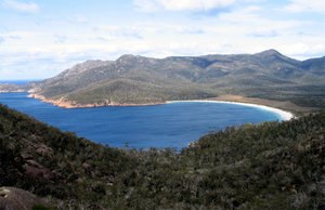
Freycinet National Park
Freycinet is a national park on the east coast of Tasmania, Australia, 125 km northeast of Hobart. It occupies a large part of the Freycinet Peninsula, named after French navigator Louis de Freycinet, and Schouten Island....
and created Tasman
Tasman National Park
Tasman National Park is located in eastern Tasmania, Australia, 56 kilometres east of Hobart.-History:The park was proclaimed under the Regional Forest Agreement on 30 April 1999. The Tasman Island Lighthouse is located on Tasman Island, which is part of the park...
and Savage River
Savage River National Park
Savage River is a national park in Tasmania , 233 km northwest of Hobart. It is the largest undisturbed area of temperate rainforest in Australia....
National Parks. Offsetting these gains were 700 km² of reserves which were made available for forestry development.
A further departmental merger occurred after the 1998 elections with an amalgamation into the Department of Primary Industries and Fisheries and the Government Analytical and Forensic Laboratories (GAFL) creating the Department of Primary Industries, Water and Environment (DPIWE).
The Parks and Wildlife Service was split into two separate divisions: the Resource Management and Conservation Division had responsibility for the natural and cultural resources and the Parks and Wildlife Service covered Tasmania's parks, reserves and World Heritage Areas. The Parks and Wildlife Service was separated from the Department of Primary Industries, Water and Environment following the 2002 State elections, becoming part of the Department of Tourism, Parks, Heritage and the Arts (DTPHA), while the Resource Management and Conservation Division remained part of the DPIWE.
In 2002 three islands, Deal, Erith and Dover were declared as part of the Kent Group National Park and marine protected areas were created there and at Port Davey-Bathurst Harbour
South West Wilderness, Tasmania
The South West Wilderness of Tasmania, Australia is a remote and inaccessible corner of the island state containing unspoilt scenery, rugged peaks, wild rivers, unique flora and fauna, and a long and rugged coastline...
.
In April 2006 the Department incorporated the Environment Division from Department of Primary Industries, Water and Environment. This led to a renaming of the Department to the Department of Tourism, Arts and the Environment (DTAE).
In 2007 the Tasmanian Coast Conservation Fund
Tasmanian Coast Conservation Fund
The Tasmanian Coast Conservation Fund is a non-profit charitable fund dedicated to providing funding for the preservation of national parks in Tasmania...
was established. Tour company operator Robert Pennicott founder of Bruny Island Cruises and Tasman Island Cruises came together with environmental group WILDCARE to establish the fund. While operating separately to the Tasmanian Parks and Wildlife Service, the fund is used to provide funding to the Parks and Wildlife Service to assist environmental protection and conservation projects in Tasmania's National Parks.