
Narawntapu National Park
Encyclopedia
Narawntapu is a national park in Tasmania
, Australia
. It lies on Tasmania's north coast, adjoining Bass Strait
, between Port Sorell
in the west and the mouth of the Tamar River
in the east. It lies about 20 km east of Devonport
, 60 km north-west of Launceston
and 250 km north of Hobart.
Narawntapu encompasses islands in the Port Sorell estuary and the Carbuncle
, as well as land extending to low water mark, including intertidal mudflat
s. The highest point of the park is 392 m ASL
. It is listed on Australia's Register of the National Estate
.
Because of its proximity to the tourist centres of Devonport and Port Sorell, Narawntapu is popular with visitors. It has been referred to as "Tasmania's Serengeti
", owing to the abundance of wildlife in the Springlawn area of the park, the main access point for visitors.
' was deterring potential visitors. 'Narawntapu' is of Tasmanian Aboriginal
origin, referring to the coastal promontories West Head and Badger Head within the park.
in January and 9°C
in July.
 Vegetation communities represented in the park include coastal heathland, dry sclerophyll
woodland
, herbland, grassland
and salt marsh
. The rare Pygmy Clubmoss
has been recorded from the park.
A feature of the park is the high density of marsupial
s present, including Eastern Grey Kangaroo
s, Bennett's Wallabies, Tasmanian Pademelon
s, Common Wombat
s and Tasmanian Devil
s. Eastern
and Spotted-tail Quolls are also found there as well as Platypus
es and Echidnas
. The birdlife is rich and includes threatened species such as the Hooded Plover
, Tasmanian Wedge-tailed Eagle
and Swift Parrot
. The intertidal mudflat
s in the North East Arm area of the park are an important foraging area for migratory
wader
s, and form part of the Rubicon Estuary
Important Bird Area
, identified as such by BirdLife International
bercause of their importance for Pied Oystercatcher
s.
Tasmania
Tasmania is an Australian island and state. It is south of the continent, separated by Bass Strait. The state includes the island of Tasmania—the 26th largest island in the world—and the surrounding islands. The state has a population of 507,626 , of whom almost half reside in the greater Hobart...
, Australia
Australia
Australia , officially the Commonwealth of Australia, is a country in the Southern Hemisphere comprising the mainland of the Australian continent, the island of Tasmania, and numerous smaller islands in the Indian and Pacific Oceans. It is the world's sixth-largest country by total area...
. It lies on Tasmania's north coast, adjoining Bass Strait
Bass Strait
Bass Strait is a sea strait separating Tasmania from the south of the Australian mainland, specifically the state of Victoria.-Extent:The International Hydrographic Organization defines the limits of the Bass Strait as follows:...
, between Port Sorell
Port Sorell, Tasmania
Port Sorell is a town on the north-west coast of Tasmania, Australia. It lies on the waterway of the same name, just off Bass Strait, 20 km east of Devonport and close to Shearwater and Hawley Beach...
in the west and the mouth of the Tamar River
Tamar River (Tasmania)
The Tamar River is a 70 kilometre estuarine in northern Tasmania formed by the merging of the North Esk River and South Esk Rivers at Launceston to its mouth at Low Head, north of the second largest settlement George Town and into the Bass Strait...
in the east. It lies about 20 km east of Devonport
Devonport, Tasmania
-Sport:The Devonport Football Club is an Australian Rules team competing in the Tasmanian Statewide League. The Devonport Rugby Club is a Rugby Union team competing in the Tasmanian Rugby Union Statewide League...
, 60 km north-west of Launceston
Launceston, Tasmania
Launceston is a city in the north of the state of Tasmania, Australia at the junction of the North Esk and South Esk rivers where they become the Tamar River. Launceston is the second largest city in Tasmania after the state capital Hobart...
and 250 km north of Hobart.
Narawntapu encompasses islands in the Port Sorell estuary and the Carbuncle
Carbuncle (Tasmania)
The Carbuncle is a small island, with an area of 1.91 ha, in south-eastern Australia. It is part of the North Coast Group, lying in southern Bass Strait near Port Sorell in north-west Tasmania. It is part of the Narawntapu National Park.-Fauna:...
, as well as land extending to low water mark, including intertidal mudflat
Mudflat
Mudflats or mud flats, also known as tidal flats, are coastal wetlands that form when mud is deposited by tides or rivers. They are found in sheltered areas such as bays, bayous, lagoons, and estuaries. Mudflats may be viewed geologically as exposed layers of bay mud, resulting from deposition of...
s. The highest point of the park is 392 m ASL
Above mean sea level
The term above mean sea level refers to the elevation or altitude of any object, relative to the average sea level datum. AMSL is used extensively in radio by engineers to determine the coverage area a station will be able to reach...
. It is listed on Australia's Register of the National Estate
Register of the National Estate
The Register of the National Estate is a listing of natural and cultural heritage places in Australia. The listing was initially compiled between 1976 and 2003 by the Australian Heritage Commission. The register is now maintained by the Australian Heritage Council...
.
Because of its proximity to the tourist centres of Devonport and Port Sorell, Narawntapu is popular with visitors. It has been referred to as "Tasmania's Serengeti
Serengeti
The Serengeti ecosystem is a geographical region in Africa. It is located in north Tanzania and extends to south-western Kenya between latitudes 1 and 3 S and longitudes 34 and 36 E. It spans some ....
", owing to the abundance of wildlife in the Springlawn area of the park, the main access point for visitors.
History
The park was originally reserved, as the Asbestos Range National Park, on 29 June 1976. The name was changed to Narawntapu in 2000 because of concerns that the word 'AsbestosAsbestos
Asbestos is a set of six naturally occurring silicate minerals used commercially for their desirable physical properties. They all have in common their eponymous, asbestiform habit: long, thin fibrous crystals...
' was deterring potential visitors. 'Narawntapu' is of Tasmanian Aboriginal
Tasmanian languages
The Tasmanian languages, or Palawa languages, were the languages indigenous to the island of Tasmania. Based on short wordlists, it appears that there were anywhere from five to sixteen languages on Tasmania....
origin, referring to the coastal promontories West Head and Badger Head within the park.
Climate
Narawntapu has a temperate maritime climate with an annual, mainly winter, rainfall of 750 mm. The prevailing winds are from the north-east and north-west. Mean temperatures are 17°CCelsius
Celsius is a scale and unit of measurement for temperature. It is named after the Swedish astronomer Anders Celsius , who developed a similar temperature scale two years before his death...
in January and 9°C
Celsius
Celsius is a scale and unit of measurement for temperature. It is named after the Swedish astronomer Anders Celsius , who developed a similar temperature scale two years before his death...
in July.
Flora and fauna
Sclerophyll
Sclerophyll is the term for a type of vegetation that has hard leaves and short internodes . The word comes from the Greek sclero and phyllon ....
woodland
Woodland
Ecologically, a woodland is a low-density forest forming open habitats with plenty of sunlight and limited shade. Woodlands may support an understory of shrubs and herbaceous plants including grasses. Woodland may form a transition to shrubland under drier conditions or during early stages of...
, herbland, grassland
Grassland
Grasslands are areas where the vegetation is dominated by grasses and other herbaceous plants . However, sedge and rush families can also be found. Grasslands occur naturally on all continents except Antarctica...
and salt marsh
Salt marsh
A salt marsh is an environment in the upper coastal intertidal zone between land and salt water or brackish water, it is dominated by dense stands of halophytic plants such as herbs, grasses, or low shrubs. These plants are terrestrial in origin and are essential to the stability of the salt marsh...
. The rare Pygmy Clubmoss
Phylloglossum
Phylloglossum, a genus in the clubmoss family Huperziaceae, is a small plant superficially resembling a tiny grass plant, growing with a rosette of slender leaves 2-5 cm long from an underground bulb-like root...
has been recorded from the park.
A feature of the park is the high density of marsupial
Marsupial
Marsupials are an infraclass of mammals, characterized by giving birth to relatively undeveloped young. Close to 70% of the 334 extant species occur in Australia, New Guinea, and nearby islands, with the remaining 100 found in the Americas, primarily in South America, but with thirteen in Central...
s present, including Eastern Grey Kangaroo
Eastern Grey Kangaroo
The Eastern Grey Kangaroo is a marsupial found in southern and eastern Australia, with a population of several million. It is also known as the Great Grey Kangaroo and the Forester Kangaroo...
s, Bennett's Wallabies, Tasmanian Pademelon
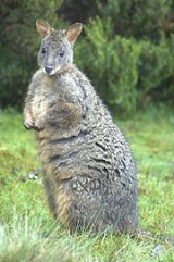
Tasmanian Pademelon
The Tasmanian Pademelon , also known as the Rufous-bellied Pademelon or Red-bellied Pademelon, is the sole endemic species of pademelon found in Tasmania, and formerly throughout south-eastern Australia...
s, Common Wombat
Common Wombat
The common wombat , also known as the coarse-haired wombat or bare-nosed wombat, is a marsupial, one of three species of wombats and the only one in the genus Vombatus. The common wombat grows to an average of long and a weight of .- Taxonomy :The common wombat was first described by George Shaw...
s and Tasmanian Devil
Tasmanian Devil
The Tasmanian devil is a carnivorous marsupial of the family Dasyuridae, now found in the wild only on the Australian island state of Tasmania. The size of a small dog, it became the largest carnivorous marsupial in the world following the extinction of the thylacine in 1936...
s. Eastern
Eastern Quoll
The Eastern Quoll , also known as the Eastern Native Cat, is a medium-sized carnivorous dasyurid marsupial native to Australia. They are now considered extinct on the mainland, but remain widespread and even locally common in Tasmania...
and Spotted-tail Quolls are also found there as well as Platypus
Platypus
The platypus is a semi-aquatic mammal endemic to eastern Australia, including Tasmania. Together with the four species of echidna, it is one of the five extant species of monotremes, the only mammals that lay eggs instead of giving birth to live young...
es and Echidnas
Short-beaked Echidna
The short-beaked echidna , also known as the spiny anteater because of its diet of ants and termites, is one of four living species of echidna and the only member of the genus Tachyglossus...
. The birdlife is rich and includes threatened species such as the Hooded Plover
Hooded Plover
The Hooded Dotterel or Hooded Plover is a species of bird in the Charadriidae family. It is endemic to southern Australia and Tasmania. There are two recognized subspecies, both of which are classifed as Endangered....
, Tasmanian Wedge-tailed Eagle
Tasmanian Wedge-tailed Eagle
The Tasmanian Wedge-tailed Eagle is an endangered bird of Tasmania. It is a subspecies of the more common Wedge-tailed Eagle.-Description:...
and Swift Parrot
Swift Parrot
The Swift Parrot breeds in Tasmania and migrates north to south eastern Australia from Griffith-Warialda in New South Wales and west to Adelaide in the winter. It is related to the rosellas, with the feeding habits of a lorikeet...
. The intertidal mudflat
Mudflat
Mudflats or mud flats, also known as tidal flats, are coastal wetlands that form when mud is deposited by tides or rivers. They are found in sheltered areas such as bays, bayous, lagoons, and estuaries. Mudflats may be viewed geologically as exposed layers of bay mud, resulting from deposition of...
s in the North East Arm area of the park are an important foraging area for migratory
Bird migration
Bird migration is the regular seasonal journey undertaken by many species of birds. Bird movements include those made in response to changes in food availability, habitat or weather. Sometimes, journeys are not termed "true migration" because they are irregular or in only one direction...
wader
Wader
Waders, called shorebirds in North America , are members of the order Charadriiformes, excluding the more marine web-footed seabird groups. The latter are the skuas , gulls , terns , skimmers , and auks...
s, and form part of the Rubicon Estuary
Rubicon Estuary
The Rubicon Estuary is an estuary on the central coast of northern Tasmania, south-eastern Australia, lying next to the town of Port Sorell.-Description:...
Important Bird Area
Important Bird Area
An Important Bird Area is an area recognized as being globally important habitat for the conservation of bird populations. Currently there are about 10,000 IBAs worldwide. The program was developed and sites are identified by BirdLife International...
, identified as such by BirdLife International
BirdLife International
BirdLife International is a global Partnership of conservation organisations that strives to conserve birds, their habitats and global biodiversity, working with people towards sustainability in the use of natural resources...
bercause of their importance for Pied Oystercatcher
Pied Oystercatcher
The Pied Oystercatcher, Haematopus longirostris, is a species of oystercatcher. It is a wading bird native to Australia and commonly found on its coastline. The similar South Island Pied Oystercatcher The Pied Oystercatcher, Haematopus longirostris, is a species of oystercatcher. It is a wading...
s.