

Local Government Areas of Tasmania
Encyclopedia
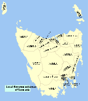
Local Government Areas of TasmaniaTasmaniaTasmania is an Australian island and state. It is south of the continent, separated by Bass Strait. The state includes the island of Tasmania—the 26th largest island in the world—and the surrounding islands. The state has a population of 507,626 , of whom almost half reside in the greater Hobart...
, AustraliaAustraliaAustralia , officially the Commonwealth of Australia, is a country in the Southern Hemisphere comprising the mainland of the Australian continent, the island of Tasmania, and numerous smaller islands in the Indian and Pacific Oceans. It is the world's sixth-largest country by total area...
This article also includes lists of towns, suburbs and localities of Tasmania.| LocalGovernmentArea | Principal town | Land Area (km²) | PopulationJune 2006estimate | Density | Region |
|---|---|---|---|---|---|
| Break O'Day | St Helens St Helens, Tasmania St Helens is the largest town on the north-east coast of Tasmania, Australia, on Georges Bay. It is located on the Tasman Highway, about 160 km east of Tasmania's second largest city, Launceston. In the early 2000s, the town was one of the fastest growing areas of Tasmania, and reached a population... |
3,809.8 | 6,218 | 1.6 | North-east |
| Brighton Brighton Council The Brighton Council or Municipality of Brighton is a Local Government Area of Tasmania. It in based in the town of Brighton, and covers the towns of Pontville and Tea Tree. It also covers the far northern Hobart suburbs of Bridgewater, Gagebrook, Honeywood and Old Beach.Brighton Council has one... |
Brighton Brighton, Tasmania Brighton is a suburb 27km north of Hobart, in Tasmania, Australia. It lies between Pontville and the outer Hobart suburb of Bridgewater on the Midland Highway. At the 2006 census, Brighton had a population of 3,145.-History:... |
168 | 14,329 | 85.3 | Hobart |
| Central Coast | Ulverstone Ulverstone, Tasmania Ulverstone is a town on the northwest coast of Tasmania, Australia. It lies at the mouth of the Leven River, on Bass Strait. It is on the Bass Highway, west of Devonport and east of Penguin.... |
931.1 | 21,259 | 22.8 | North-west and west coast |
| Central Highlands | Hamilton Hamilton, Tasmania Hamilton is a small rural town north west of Hobart in Tasmania on the Lyell Highway. At the 2006 census, the town and surrounding area had a population of 300.... |
7,976.4 | 2,316 | 0.3 | Central |
| Circular Head | Smithton Smithton, Tasmania Smithton is a town in the far north-west coast of Tasmania, Australia. It lies on the Bass Highway, 85 km north-west of Burnie. At the 2006 census, Smithton had a population of 3,361. Smithton is the administrative centre of the Circular Head Council... |
4,917 | 8,188 | 1.7 | North-west and west coast |
| Burnie (City of) City of Burnie The City of Burnie is a Local Government Area of Tasmania. It covers the city of Burnie and surrounding areas, although it does not include the town of Somerset - usually classed as part of the Burnie metropolitan area.... |
Burnie Burnie, Tasmania - Sport :Australian rules football is popular in Burnie. The city's team is the Burnie Dockers Football Club in the Tasmanian State League.Rugby union is also played in Burnie. The local club is the Burnie Rugby Union Club. They are the current Tasmanian Rugby Union Statewide Division Two Premiers... |
618 | 19,701 | 31.9 | North-west and west coast |
| Clarence (City of) | Rosny Park Rosny Park, Tasmania Rosny Park is a suburb of Hobart, Tasmania, located in the City of Clarence on the eastern shore of the Derwent River. It is about five kilometres from the city centre of Hobart... |
386 | 50,808 | 131.6 | Hobart |
| Devonport (City of) City of Devonport The City of Devonport is a Local Government Area of Tasmania, encompassing the city of Devonport in northern Tasmania. The City is governed by the Devonport City Council.... |
Devonport Devonport, Tasmania -Sport:The Devonport Football Club is an Australian Rules team competing in the Tasmanian Statewide League. The Devonport Rugby Club is a Rugby Union team competing in the Tasmanian Rugby Union Statewide League... |
116 | 24,880 | 214.5 | North-west and west coast |
| Glenorchy (City of) City of Glenorchy The City of Glenorchy is a Local Government Area of Tasmania which covers several northern suburbs of Hobart including the suburb of Glenorchy by the same name. The city is managed by Glenorchy City Council. Current mayor is Stuart Slade.- History :... |
Glenorchy Glenorchy, Tasmania Glenorchy is a business district and suburb in the northern part of greater Hobart, capital of the state of Tasmania, Australia. The land was originally used for agriculture but is now a largely suburban, working-class area... |
120 | 44,179 | 368.2 | Hobart |
| Hobart (City of) City of Hobart The City of Hobart is a Local Government Area of Tasmania, Australia. It is one of three local government areas covering the metropolitan area of the state capital, Hobart.-Government:... |
Hobart | 76.2 | 49,556 | 650.3 | Hobart |
| Launceston (City of) City of Launceston The City of Launceston is a Local Government Area of Tasmania, encompassing about half of the greater Launceston area in northern Tasmania. It also includes a region to the north east of Launceston, encompassing towns such as Lilydale... |
Launceston Launceston, Tasmania Launceston is a city in the north of the state of Tasmania, Australia at the junction of the North Esk and South Esk rivers where they become the Tamar River. Launceston is the second largest city in Tasmania after the state capital Hobart... |
1,405 | 64,620 | 46 | Launceston |
| Derwent Valley | New Norfolk New Norfolk, Tasmania -References:5. Fellowship of First Fleeters.6. New Norfolk's History and Achievements by Joe Cowburn and Rita Cox 1986-External links:* has extensive local information, history, photographs, resources and attractions... |
4,111 | 9,692 | 2.4 | South-east |
| Dorset | Scottsdale Scottsdale, Tasmania Scottsdale is a town in the north-east of Tasmania, Australia. It lies on the Tasman Highway, around north-east of Launceston and south-east of the coastal town of Bridport. It is part of the Dorset Council.... |
3,196 | 7,253 | 2.3 | North-east |
| Flinders Flinders Council Flinders Council is a Local Government Area of Tasmania. It covers more than 60 islands off the north-eastern tip of Tasmania at the eastern end of Bass Strait. Of these 60, only three have permanent populations: Clarke Island, Cape Barren Island, and the largest and most populous, Flinders Island.... |
Whitemark Whitemark, Tasmania Whitemark is the main settlement of Flinders Island, in the Australian state of Tasmania.... |
1,333 | 881 | 0.7 | North-east |
| George Town George Town Council The George Town Council is a Local Government Area of the state of Tasmania in Australia. It covers George Town and the surrounding area.In 2006, George Town had the highest birth rate in Tasmania, with a TFR of 3.75 children per women.... |
George Town George Town, Tasmania George Town is one of the larger towns in north-east Tasmania, on the eastern bank of the mouth of the Tamar River. At the 2006 census, George Town had a population of 4,266. It is the regional centre of the George Town Council Local Government Area.... |
652.6 | 6,744 | 10.3 | Launceston |
| Glamorgan Spring Bay | Triabunna Triabunna, Tasmania Triabunna is the largest township on the east coast of Tasmania, is the civic and municipal heart of the Glamorgan Spring Bay Council, and is located 84 kilometres to the northeast of the state capital Hobart. It is a coastal town situated on the Tasman Highway, and is sheltered within Spring Bay... |
2,522 | 4,329 | 1.7 | South-east |
| Huon Valley | Huonville Huonville, Tasmania Huonville is a town on the Huon River, in the south-east of Tasmania, Australia. The town lies within the Huon Valley Council area. It lies 38 km south of Hobart on the Huon Highway. At the 2006 census, Huonville had a population of 1,806.... |
5,497 | 14,442 | 2.6 | South-east |
| Kentish | Sheffield Sheffield, Tasmania Sheffield is a town situated 23 km inland from Devonport on the north-west coast of Tasmania, Australia's island state. Sheffield has long been the rural hub for the Mount Roland area. The Sheffield area is well known for its high quality butterfat production via dairy farming. The area is... |
1,187 | 5,965 | 5 | North-west and west coast |
| King Island King Island Council King Island Council is a Local Government Area of Tasmania. It covers the whole of King Island in Bass Strait.-External links:*... |
Currie Currie, Tasmania Currie is the largest township on King Island, Tasmania, at the western entrance to Bass Strait. At the 2006 census, Currie had a population of 746.-Geography:... |
1,100 | 1,703 | 1.5 | North-west and west coast |
| Kingborough | Kingston Kingston, Tasmania Kingston is a township and region on the outskirts of Hobart, Tasmania, Australia. Nestled 15 km south of the city between and around several hills, Kingston is the council seat of its wider municipality, the Kingborough Council, and today serves as the gateway between Hobart and the... |
717 | 31,706 | 44.2 | Hobart |
| Latrobe Latrobe Council The Latrobe Council is a Local Government Area of Tasmania. It covers the town of Latrobe and surrounding regions, including the coastal towns of Shearwater and Port Sorell.... |
Latrobe Latrobe, Tasmania Latrobe is a town in northern Tasmania, Australia, situated on the Mersey River. It lies 8 km south-east of Devonport on the Bass Highway. It is main centre of the Latrobe Council. At the 2006 census, Latrobe had a population of 2,843.... |
550 | 8,888 | 16.2 | North-west and west coast |
| Meander Valley | Westbury Westbury, Tasmania Westbury is a town in the central north of Tasmania, Australia. It lies 30 km west of Launceston on the Bass Highway, and at the 2006 census had a population of 1,357. It is part of, and the headquarters of, the Meander Valley Council area.... |
3,821 | 18,938 | 5 | Launceston |
| Northern Midlands | Longford Longford, Tasmania Longford is a town in the north-east of Tasmania, Australia. It lies 175 m above sea level at the convergence of the Macquarie River and the South Esk River, 21 km south of Launceston. It is just south of the Illawarra Road, a road connecting the Bass and Midland Highways. It has a... |
5,130 | 12,505 | 2.4 | Central |
| Sorell Sorell Council Sorell Council is a Local Government Area of Tasmania, Australia. The municipality of Sorell is one of the fastest growing areas in Tasmania.... |
Sorell Sorell, Tasmania Sorell is a town in Tasmania, Australia, north-east of Hobart. It is on the Tasman Highway which continues up the east coast of Tasmania. At the 2006 census, Sorell had a population of 1,546.... |
582.6 | 12,131 | 20.8 | South-east |
| Southern Midlands | Oatlands Oatlands, Tasmania Oatlands is an important historical village built on the shores of Lake Dulverton in the centre of Tasmania, Australia. Oatlands is located 84 km north of Hobart and 115 km south of Launceston on the Midland Highway... |
2,561 | 5,845 | 2.3 | Central |
| Tasman | Nubeena Nubeena, Tasmania Nubeena is a town on the Tasman Peninsula, Tasmania, a township of Tasman Council, and seat of the municipality. At the 2006 census, Nubeena had a population of 277.-Geography:... |
660 | 2,317 | 3.5 | South-east |
| Waratah-Wynyard | Wynyard Wynyard, Tasmania Wynyard is a rural town on the north-west coast of Tasmania, Australia. It lies west of Burnie on the Bass Highway at the mouth of the Inglis River.... |
1,187 | 13,815 | 11.6 | North-west and west coast |
| West Coast West Coast Council The West Coast Council is a Local Government Area of Tasmania. It covers much of the west of Tasmania. It is the largest Local Government Area of Tasmania by area, and the second least densely populated, after the Central Highlands. It takes in the West Coast Range as well as portions of World... |
Zeehan Zeehan, Tasmania Zeehan is a town on the west coast of Tasmania, Australia. It lies southwest of Burnie. At the 2006 census, Zeehan had a population of 845. It is part of the Municipality of West Coast.... |
9,574.5 | 5,171 | 0.5 | North-west and west coast |
| West Tamar | Beaconsfield Beaconsfield, Tasmania Beaconsfield is a town near the Tamar River, in the north-east of Tasmania, Australia. It lies 40 kilometres north of Launceston on the West Tamar Highway. It is part of the Municipality of West Tamar... |
689 | 21,543 | 31.3 | Launceston |
| Tasmania Tasmania Tasmania is an Australian island and state. It is south of the continent, separated by Bass Strait. The state includes the island of Tasmania—the 26th largest island in the world—and the surrounding islands. The state has a population of 507,626 , of whom almost half reside in the greater Hobart... |
Hobart Hobart Hobart is the state capital and most populous city of the Australian island state of Tasmania. Founded in 1804 as a penal colony,Hobart is Australia's second oldest capital city after Sydney. In 2009, the city had a greater area population of approximately 212,019. A resident of Hobart is known as... |
65,594 | 489,922 | 7.5 |
Brighton CouncilBrighton CouncilThe Brighton Council or Municipality of Brighton is a Local Government Area of Tasmania. It in based in the town of Brighton, and covers the towns of Pontville and Tea Tree. It also covers the far northern Hobart suburbs of Bridgewater, Gagebrook, Honeywood and Old Beach.Brighton Council has one...
- Hobart suburbs:
- BridgewaterBridgewater, TasmaniaBridgewater, Tasmania, is one greater Hobart's northern-most suburbs, located 19 km from the city. It is situated on the eastern shore of the Derwent River. It is a suburb of the local government area of the Municipality of Brighton....
- GagebrookGagebrook, TasmaniaGagebrook, Tasmania is one of the northern-most suburbs of Hobart, located on the eastern shore of the Derwent River between the suburbs of Bridgewater and Old Beach. It is part of the local government area of the Municipality of Brighton...
- Old BeachOld Beach, TasmaniaOld Beach is a suburb of Hobart based in the municipality of Brighton, Tasmania, Australia. It has a population of approximately 2000 which is rising due to Tasmania's housing boom. It is the location of the Baskerville Raceway.-Sources:...
- Bridgewater
- BrightonBrighton, TasmaniaBrighton is a suburb 27km north of Hobart, in Tasmania, Australia. It lies between Pontville and the outer Hobart suburb of Bridgewater on the Midland Highway. At the 2006 census, Brighton had a population of 3,145.-History:...
- PontvillePontville, TasmaniaPontville is a small rural community north of Hobart, in the south east of Tasmania, Australia. At the 2006 census, Pontville had a population of 2,166....
- Tea Tree
City of Clarence
- Hobart suburbs:
- ActonActon, TasmaniaActon is a suburb of the City of Burnie in north-west Tasmania, Australia.It's 2006 population was 1,352....
- BelleriveBellerive, TasmaniaBellerive is a suburb of the City of Clarence, part of the greater Hobart area, Tasmania, Australia. It stretches from Kangaroo Bay where it borders Rosny Park, around the curved shoreline of Bellerive Esplanade to Kangaroo Bluff, then down to Bellerive Beach and east to Second Bluff, where...
- CambridgeCambridge, TasmaniaCambridge is a suburb in the greater area of Hobart, capital of Tasmania, Australia. It is in the City of Clarence Local Government Area. The suburb is situated in close proximity with Hobart International Airport and the Cambridge Aerodrome, and is approximately 18 km to Hobart via the Tasman...
- Clarendon ValeClarendon Vale, TasmaniaClarendon Vale is a suburb of Hobart, capital of Tasmania, Australia. It is in the City of Clarence Local Government Area.Like nearby Rokeby, it was originally a public housing area in the 1970s, however like the trend in many public housing areas in Hobart, much of the public housing stock has...
- CremorneCremorne, TasmaniaCremorne is a town located on the South Arm Peninsula on the outskirts of Hobart, Tasmania, Australia. It is part of the City of Clarence....
- Geilston BayGeilston Bay, TasmaniaGeilston Bay is a small suburb of Hobart near Lindisfarne, in the City of Clarence located on the Eastern Shore of the Derwent River. Its a nature-rich suburb with houses built right next to bushland. Shag Bay Aboriginal Site and the local Boat Club are two main features of the suburb...
- HowrahHowrah, TasmaniaHowrah is a suburb of the City of Clarence, part of the greater Hobart area, Tasmania, Australia. It is south of Bellerive and north of Tranmere.Howrah is a beachside suburb, with views across the Derwent River and Storm Bay to Hobart City...
- LauderdaleLauderdale, TasmaniaLauderdale is a town on the outskirts of Hobart, capital of Tasmania, Australia. The population of Lauderdale is approximately 2,388 . It is in the local government area of City of Clarence. The town is situated on the eastern side of a thin Isthmus that connects the South Arm peninsula to the...
- LindisfarneLindisfarne, TasmaniaLindisfarne is a suburb of Hobart's Eastern Shore, located approximately 6 kilometres from the City Centre and is part of the municipal City of Clarence.-History:...
- MorningtonMornington, TasmaniaMornington is a suburb of the City of Clarence in Tasmania, Australia. It is part of greater Hobart, located approximately 7 kilometres from the CBD...
- Opossum BayOpossum Bay, TasmaniaOpossum Bay is a town located on the South Arm Peninsula on the outskirts of Hobart, Tasmania, Australia. It is part of the City of Clarence....
- OtagoOtago, TasmaniaOtago is a suburb on the eastern shore of Hobart, capital of Tasmania, Australia. It is located on the shores of Otago Bay.The area takes its name from the iron barque Otago, the only command of the author Joseph Conrad, which was dismantled at a shipbreaking establishment that operated at the bay...
- RisdonRisdon, TasmaniaRisdon is a suburb of Hobart, capital city of Tasmania, Australia. It is west of Risdon Vale. Eucalyptus risdonii is native to this location, and is the emblem of Geilston Bay High School....
- Risdon ValeRisdon Vale, TasmaniaRisdon Vale is an outer suburb of Hobart, capital of Tasmania, Australia.Located on the Eastern Shore of the Derwent River, and adjacent to Risdon Cove, which was the site of the first British settlement in Van Diemen's Land....
- RokebyRokeby, TasmaniaRokeby is a suburb of Hobart, capital of Tasmania, Australia. It is located on the eastern shore of the Derwent River and is part of the City of Clarence Local Government Area....
- Rose BayRose Bay, TasmaniaRose Bay is a suburb of City of Clarence in greater Hobart, capital city of Tasmania, Australia.Primarily a residential area serviced by shopping centres at Lindisfarne and Rosny Park....
- RosnyRosny, TasmaniaRosny is a suburb of the City of Clarence, part of the greater Hobart area, Tasmania, Australia. It is located on the eastern shore of the Derwent River, between the suburbs of Montagu Bay and Rosny Park, approximately 4 kilometres from Hobart's centre. Rosny is the residential part of its...
- Seven Mile Beach - South ArmSouth Arm, TasmaniaSouth Arm is a town located on the South Arm Peninsula on the outskirts of Hobart, Tasmania, Australia. It is part of the City of Clarence.-Sources:...
- TranmereTranmere, TasmaniaTranmere is a suburb of Hobart, capital of Tasmania, Australia. The suburb is in the Local Government Area of City of Clarence, and lies in close proximity to Howrah....
- WarraneWarrane, TasmaniaWarrane is a suburb of Hobart, Tasmania, in the City of Clarence. It is approximately from Hobart's CBD. It is located between Rosny Park and Mornington and runs parallel to the Tasman Highway....
- Acton
- RichmondRichmond, TasmaniaRichmond is a town in Tasmania about 25 km north-east of Hobart, in the Coal River region, between the Midland Highway and Tasman Highway. At the 2006 census, Richmond had a population of 880....
City of GlenorchyCity of GlenorchyThe City of Glenorchy is a Local Government Area of Tasmania which covers several northern suburbs of Hobart including the suburb of Glenorchy by the same name. The city is managed by Glenorchy City Council. Current mayor is Stuart Slade.- History :...
- Hobart suburbs:
- Austins FerryAustins Ferry, TasmaniaAustins Ferry is a suburb of Hobart, capital city of Tasmania, Australia. It is predominantly a new homes area.Austins Ferry is named after James Austin , who had been transported to Port Phillip as a convict in 1803 along with his cousin John Earl, and arrived in Van Diemens Land in 1804...
- BerriedaleBerriedale, TasmaniaBerriedale is a suburb in the northern suburbs of Hobart, capital of Tasmania, Australia. It is in the local government area of City of Glenorchy. The suburb is situated between the suburbs of Chigwell and Rosetta. There are no educational institutions within Berriedale, however there are primary...
- ChigwellChigwell, TasmaniaChigwell is a suburb in the 'northern suburbs' area of Hobart, the capital city of Tasmania, Australia. The suburb is situated between the suburbs of Berriedale, Claremont and Glenlusk. The suburb shares its border with Berriedale along the Brooker Highway and the streets north of Berriedale Rd...
- ClaremontClaremont, TasmaniaClaremont is a suburb of the City of Glenorchy, part of the greater Hobart area, Tasmania, Australia. It is named after Claremont House, which was built in the 1830s by local settler Henry Bilton, who named it after one of the royal homes of England. Claremont was the home of an Army training...
- CollinsvaleCollinsvale, TasmaniaCollinsvale is a suburb of the City of Glenorchy, part of the greater Hobart area in Tasmania, Australia.The area was originally known called Sorell Creek, and was inhabited mostly by British settlers in the mid-nineteenth century...
- Derwent ParkDerwent Park, TasmaniaDerwent Park is a suburb of Hobart, Tasmania, Australia. It is part of the City of Glenorchy.It is predominantly a light commercial and industrial area....
- Dowsing PointDowsing Point, TasmaniaDowsing Point is a locality of the greater area of Hobart, Tasmania, Australia. It is part of the City of Glenorchy and encompasses the area of land North-East of Goodwood protruding into the Derwent River...
- GlenluskGlenlusk, TasmaniaGlenlusk is a semi-rural suburb of Hobart, Tasmania, Australia. It is in the City of Glenorchy Local Government Area. It is west of Chigwell.-Sources:...
- GlenorchyGlenorchy, TasmaniaGlenorchy is a business district and suburb in the northern part of greater Hobart, capital of the state of Tasmania, Australia. The land was originally used for agriculture but is now a largely suburban, working-class area...
- GoodwoodGoodwood, TasmaniaGoodwood is a suburb of Hobart, Tasmania, Australia. It is part of the City of Glenorchy.The small residential suburb starts just south-east of the Brooker Highway and Goodwood Road junction. It is best known for its annual Christmas light decorations. Most houses in Goodwood were built in the...
- GrantonGranton, TasmaniaGranton is a suburb of Hobart, capital city of Tasmania, Australia. It is the most northern suburb of the City of Glenorchy Local Government Area....
- LutanaLutana, TasmaniaLutana is a suburb of Hobart, Tasmania, Australia. It is part of the City of Glenorchy.It is a large residential suburb located between the Brooker Highway and Derwent River. It was originally built by the Electrolytic Zinc company as homes for its employees at the nearby zinc smelter. The...
- MontroseMontrose, TasmaniaMontrose, is a suburb in the northern suburbs of Hobart, capital of Tasmania, Australia. The suburb is situated in close promity with Rosetta. Montrose is the suburb directly north of Glenorchy and lies within the local government area of City of Glenorchy...
- MoonahMoonah, TasmaniaMoonah is a central business district and a large suburb within the greater area of Hobart, Tasmania. Moonah lies in the Local government area of City of Glenorchy. It was originally land given free to settlers along the banks of the New Town Rivulet. These areas eventually became known as the...
- RosettaRosetta, TasmaniaRosetta is a suburb in the northern suburbs of Hobart, capital of the Australian state of Tasmania. It is in the local government area of City of Glenorchy. The suburb is situated between the suburbs of Berriedale and Montrose and is approximately 15 minutes drive from Hobart. There is a primary...
- West MoonahWest Moonah, TasmaniaWest Moonah is a predominantly residential suburb of Hobart, Tasmania, Australia. It is part of the City of Glenorchy Local Government Area. It is becoming a popular area. Most schools are private or religious...
- Austins Ferry
City of HobartCity of HobartThe City of Hobart is a Local Government Area of Tasmania, Australia. It is one of three local government areas covering the metropolitan area of the state capital, Hobart.-Government:...
- HobartHobartHobart is the state capital and most populous city of the Australian island state of Tasmania. Founded in 1804 as a penal colony,Hobart is Australia's second oldest capital city after Sydney. In 2009, the city had a greater area population of approximately 212,019. A resident of Hobart is known as...
suburbs:- Battery PointBattery Point, TasmaniaBattery Point is a suburb of the city of Hobart, Tasmania, Australia. It is immediately south of the Central business district. It is in the local government area of City of Hobart....
- DynnyrneDynnyrne, TasmaniaDynnyrne is a suburb of Hobart, Tasmania. It is situated in the hills south-west of the city, surrounded by the suburbs of Sandy Bay, South Hobart and Tolmans Hill. Dynnyrne is Tasmania's second most affluent suburb according to documents released by the Australian Taxation Office. The postal code...
- Fern TreeFern Tree, TasmaniaFern Tree , is Tasmania's highest community of any size. The name Fern Tree is adapted from the common name of the plant Dicksonia antarctica which grows abundantly in the area...
- GlebeGlebe, TasmaniaGlebe is a suburb of Hobart, capital city of Tasmania, Australia. The suburb is a very small area adjacent to the city on the same part of land as the Queens Domain, the Royal Tasmanian Botanical Gardens and the Hobart Aquatic Center....
- HobartHobartHobart is the state capital and most populous city of the Australian island state of Tasmania. Founded in 1804 as a penal colony,Hobart is Australia's second oldest capital city after Sydney. In 2009, the city had a greater area population of approximately 212,019. A resident of Hobart is known as...
- Lenah ValleyLenah Valley, TasmaniaLenah Valley is a suburb of Hobart, Tasmania. It is situated in the foothills of Mount Wellington, north of the CBD between Mount Stuart, New Town and the City of Glenorchy....
- Mount Nelson - Mount Stuart - New TownNew Town, TasmaniaNew Town is a suburb of the city of Hobart, Tasmania, Australia, located about 4 km north of the central business district of Hobart. One of the city's oldest suburbs, it is now an inner city residential suburb. Many of its streets are lined with Federation style cottages...
- North HobartNorth Hobart, TasmaniaNorth Hobart is a suburb of the city of Hobart, Tasmania, Australia. As its name suggests, it lies directly north of the CBD.The main street of North Hobart is Elizabeth Street, which extends northward from the Elizabeth Street Mall in the city, through North Hobart, and then becomes the Main Road...
- South HobartSouth Hobart, TasmaniaSouth Hobart is one of Hobart's southern suburbs. It is bound by Dynnyrne, Fern Tree, West Hobart and the CBD.A refuse tip is located here within McRobies Gully....
- West HobartWest Hobart, TasmaniaWest Hobart is an inner-city suburb of Hobart, Tasmania . It is located in the hills immediately west of the city centre, and shares the postcode 7000 with that district....
- RidgewayRidgeway, TasmaniaRidgeway is located south of Dynnyrne and can be accessed by Waterworks Road and Ridgeway Road from Dynnyrne, or via Chimney Pot Hill Road from Fern Tree....
- Sandy BaySandy Bay, TasmaniaSandy Bay is a suburb of the city of Hobart, Tasmania, Australia, located immediately south of the central business district.The suburb is home to many large homes, and adjoins the waterfront Salamanca area and Battery Point. The suburb is known as one of the city's prestigious areas...
- Tolmans HillTolmans Hill, TasmaniaTolmans Hill is a suburb of Hobart, Tasmania, Australia. It is likely to be the last large scale greenfield suburban development to take place within Hobart city....
- Battery Point
Kingborough Council
- Albion Heights
- Allens Rivulet
- Bruny Island suburbs
- Adventure Bay - Alonnah - Apollo Bay - Barnes Bay - Dennes Point - Great Bay - Killora - Lunawanna - North Bruny - Simpsons Bay - South Bruny
- Coningham
- CradocCradoc, TasmaniaCradoc is a small township on the eastern side of the Huon River south of Huonville, Tasmania. At the 2006 census, Cradoc had a population of 743....
- Electrona
- Gordon
- Hobart suburbs:
- TaroonaTaroona, TasmaniaTaroona is a major residential suburb approximately 15 minutes drive from the centre of Hobart, Tasmania on the scenic route between Hobart and Kingston...
- HowdenHowden, TasmaniaHowden is a small, relatively isolated community on the shore of North West Bay in Tasmania Australia. Nestled between the majorly-developing township of Kingston and the smaller Margate, it verges on bushland but is only a half-hour drive away from Hobart, the capital city of Tasmania...
- KingstonKingston, TasmaniaKingston is a township and region on the outskirts of Hobart, Tasmania, Australia. Nestled 15 km south of the city between and around several hills, Kingston is the council seat of its wider municipality, the Kingborough Council, and today serves as the gateway between Hobart and the...
- Kingston BeachKingston Beach, TasmaniaKingston Beach is a suburb of the greater Hobart area, capital of Tasmania, Australia. It is located on the Derwent River at the mouth of Browns Rivulet. At the nearby beach of the same name, a section of the Clifton Beach Surf Life Saving Club is located...
- Blackmans Bay - Bonnet HillBonnet Hill, TasmaniaBonnet Hill is a suburb of the greater Hobart area, capital of Tasmania, Australia. It is located on the hill of the same name, overlooking Kingston. Bonnet Hill is a popular cycling route. Located on it is the famous Shot Tower. The sides of the hill are riddled with small paths mostly leading to...
- HuntingfieldHuntingfield, TasmaniaHuntingfield is a suburb of the greater Hobart area, capital of Tasmania, Australia. It is just south of Kingston. The area is fairly new, with most homes being less than ten years old. Vodafone's Tasmanian call centre is located in Huntingfield, as is Tarremah Steiner School and Kingborough...
- Taroona
- Kaoota
- KetteringKettering, TasmaniaKettering is a coastal town on the D'Entrecasteaux Channel. Kettering and Woodbridge nestle into the coast on the D'Entrecasteaux Channel opposite Bruny Island - two tiny settlements gazing across the narrow channel at the island's low lying hills...
- Longley
- Lucaston
- MargateMargate, TasmaniaMargate is a small seaside town located on the Channel Highway between North-West Bay and the Snug Tiers, south of Kingston in Tasmania, Australia. At the 2006 census, Margate had a population of 1,368. Although more people live in the immediate region around the town...
- NeikaNeikaNeika is a suburb in Tasmania, Australia, to the north-west of Kingston....
- Oyster Cove
- Pelverata
- Sandfly
- SnugSnug, TasmaniaSnug is a small coastal town located on the Channel Highway south of Hobart in Tasmania. At the 2006 census, Snug had a population of 881. Snug is a part of the Municipality of Kingborough.-History:...
- The Lea
- Tinderbox
- Woodstock
Sorell CouncilSorell CouncilSorell Council is a Local Government Area of Tasmania, Australia. The municipality of Sorell is one of the fastest growing areas in Tasmania....
- Dodges FerryDodges Ferry, TasmaniaDodges Ferry is a small township on the eastern side of the entrance to Pittwater in south eastern Tasmania, Australia. It was named after Ralph Dodge who operated a ferry service across Pittwater from the 1820s. It is now a popular tourist locale. At the 2006 census, Dodges Ferry had a...
- DunalleyDunalley, TasmaniaDunalley is a small fishing village on the east coast of Tasmania, Australia. It is part of the Sorell Council. At the 2006 census, Dunalley had a population of 313.Nearby towns include Scottsdale and Sorell...
- Lewisham
- Midway PointMidway Point, TasmaniaMidway Point is an outlying suburb of Hobart, capital of Tasmania, Australia. It is in the local government area of Sorell Council, and is located on a small peninsula with Orielton Lagoon on its eastern side and Pitt Water on its southern and western sides...
- SorellSorell, TasmaniaSorell is a town in Tasmania, Australia, north-east of Hobart. It is on the Tasman Highway which continues up the east coast of Tasmania. At the 2006 census, Sorell had a population of 1,546....
Municipality of Derwent ValleyDerwent ValleyThe Derwent Valley Council is a Local Government Area of Tasmania, Australia. As its name suggests, it covers the upper part of the Derwent River, from the major town of New Norfolk to the remote south-west Hydro town of Strathgordon....
- BoyerBoyer, TasmaniaBoyer is a town on the eastern side of the Derwent River , opposite and slightly downstream of New Norfolk. It is named after a family who first settled in the area in the early 19th century. It is the site of Australian Newsprint Mills' plant in Tasmania...
- Bushy Park
- New NorfolkNew Norfolk, Tasmania-References:5. Fellowship of First Fleeters.6. New Norfolk's History and Achievements by Joe Cowburn and Rita Cox 1986-External links:* has extensive local information, history, photographs, resources and attractions...
- StrathgordonStrathgordon, TasmaniaStrathgordon is a locality in Tasmania, Australia at the end of the Gordon River Road, the most south westerly road in the south west of Tasmania.It is remote by Tasmanian standards with the nearest basic services away along a winding road at Maydena....
Municipality of TasmanTasman municipalityThe Tasman Council is a Local Government Area of Tasmania, covering the Tasman and Forestier Peninsulas. Its population of just over 2,400 increases to over 8,000 at peak tourist times.Port Arthur, Nubeena and Koonya are the main towns.-External links:*...
- Koonya
- MurdunnaMurdunna, TasmaniaMurdunna is a small town in south east Tasmania, at the head of King George Sound, a narrow bay opening off Norfolk Bay. Murdunna is approximately half way down the Forestier Peninsula on the Arthur Highway to Port Arthur. It is around 6 metres above sea level...
- NubeenaNubeena, TasmaniaNubeena is a town on the Tasman Peninsula, Tasmania, a township of Tasman Council, and seat of the municipality. At the 2006 census, Nubeena had a population of 277.-Geography:...
- Port ArthurPort Arthur, TasmaniaPort Arthur is a small town and former convict settlement on the Tasman Peninsula, in Tasmania, Australia. Port Arthur is one of Australia's most significant heritage areas and the open air museum is officially Tasmania's top tourist attraction. It is located approximately 60 km south east of...
Municipality of Huon ValleyHuon ValleyThe Huon Valley Council is a Local Government Area of Tasmania. It is the southern-most local government area in Australia.It encompasses the town of Huonville, on the Huon River, some surrounding towns, and many protected areas and forestry plantations...
- CygnetCygnet, TasmaniaCygnet is a small town 55 kilometres south west of Hobart, in the Huon Valley in Tasmania. At the 2006 census, Cygnet had a population of 839.-History:...
- Dover
- FranklinFranklin, TasmaniaFranklin is a small township on the western side of the Huon River in the south-east of Tasmania, between Huonville and Geeveston. At the 2006 census, Franklin had a population of 453....
- GeevestonGeeveston, TasmaniaGeeveston is a small Australian town located in the south of Tasmania on the Huon River, 62 km south west of Hobart, making it Australia's most southerly administrative centre. The town takes its name from William Geeves, an English settler who was given a land grant by Lady Jane Franklin in the...
- HuonvilleHuonville, TasmaniaHuonville is a town on the Huon River, in the south-east of Tasmania, Australia. The town lies within the Huon Valley Council area. It lies 38 km south of Hobart on the Huon Highway. At the 2006 census, Huonville had a population of 1,806....
Municipality of Glamorgan/Spring BayGlamorgan/Spring BayThe Glamorgan Spring Bay Council or Municipality of Glamorgan Spring Bay covers the southern east coast of Tasmania, Australia. It includes the towns of Swansea, Orford, Triabunna and Coles Bay, as well as the national parks at Maria Island and the Freycinet Peninsula.The council gets its name from...
- BichenoBicheno, TasmaniaBicheno is a town on the east coast of Tasmania, Australia, 185 km north-east of Hobart on the Tasman Highway, with a population of 640. It is part of the municipality of Glamorgan/Spring Bay...
- Coles BayColes Bay, TasmaniaColes Bay, the hub of Tourism on Tasmania's east coast, is an Australian town on the east Coast of Tasmania located 192 km north east of Hobart and 209 km south east of Launceston, being the main entrance point for visitors to the Freycinet National Park...
- OrfordOrford, TasmaniaOrford is an attractive coastal hamlet situated on the east coast of Tasmania, some 73 kilometres northeast of Hobart. The village is centred around the mouth of the Prosser River, on the southern margin of a substantial coastal inlet called Prosser Bay...
- SwanseaSwansea, Tasmania-Demographics:According to the 1996 census, the town's population was 495. Of the population, 25.1% were above the age of 65 - making it the Tasmanian town with the largest percentage of over-65-year-olds.-References:...
- TriabunnaTriabunna, TasmaniaTriabunna is the largest township on the east coast of Tasmania, is the civic and municipal heart of the Glamorgan Spring Bay Council, and is located 84 kilometres to the northeast of the state capital Hobart. It is a coastal town situated on the Tasman Highway, and is sheltered within Spring Bay...
Municipality of Break O'DayBreak O'DayThe Break O'Day Council is a Local Government Area of Tasmania, encompassing the northern part of the states east coast.Major towns in the area include St Helens, St Marys, Scamander, Beaumaris, Fingal and the beautiful valley of Pyengana , which is located at the foothill of the Blue Tiers and...
- FingalFingal, TasmaniaFingal is a small Australian town located in Fingal Valley in the north-east of Tasmania, on the Esk Highway.-History:The Fingal area was surveyed in 1824 by Roderic O'Connor and John Helder Wedge, and is believed to have been named after Fingal's Cave in the Inner Hebrides of Scotland rather than...
- St HelensSt Helens, TasmaniaSt Helens is the largest town on the north-east coast of Tasmania, Australia, on Georges Bay. It is located on the Tasman Highway, about 160 km east of Tasmania's second largest city, Launceston. In the early 2000s, the town was one of the fastest growing areas of Tasmania, and reached a population...
- St MarysSt Marys, TasmaniaSt Marys is a small township nestled at the junction of the Tasman Highway and the Esk Highway on the East Coast of Tasmania, Australia just 10 kilometres from the coast....
- ScamanderScamander, TasmaniaScamander is a small town situated at the mouth of the Scamander River between St Helens and St Marys on the northeast coast of Tasmania in Australia. The town is a popular holiday destination because of its wide, sandy beaches and views of the ocean...
Municipality of DorsetDorset, TasmaniaThe Dorset Council is a Local Government Area of Tasmania, encompassing the north-east part of the states mainland. The major town in the area is the regional centre Scottsdale, and smaller towns Branxholm, Bridport, Derby, Ringarooma and Winnaleah....
- BranxholmBranxholm, TasmaniaBranxholm is a small town in northeastern Tasmania. Located 93 km north east of Launceston on the Tasman Highway.Branxholm is a typical north-east Tasmania timber town nestled into the rolling hills. It is notable for its saw mills and its hop fields...
- BridportBridport, TasmaniaBridport is a small town on the north-east coast of Tasmania, Australia. It is part of the Dorset Council. At the 2006 census, Bridport had a population of 1,327....
- DerbyDerby, TasmaniaDerby is a small Australian town located in the north east of Tasmania.The area had been surveyed in 1855, but was not settled or inhabited until 1874, when George Renison Bell discovered tin in the area. The Krushka brothers discovered a large lode of tin, and set up a mine in the area, assuring...
- ScottsdaleScottsdale, TasmaniaScottsdale is a town in the north-east of Tasmania, Australia. It lies on the Tasman Highway, around north-east of Launceston and south-east of the coastal town of Bridport. It is part of the Dorset Council....
- Winnaleah
Municipality of FlindersFlinders IslandFlinders Island may refer to:In Australia:* Flinders Island , in the Furneaux Group, is the largest and best known* Flinders Island * Flinders Island , in the Investigator Group* Flinders Island...
- Cape Barren Island
- Flinders IslandFlinders IslandFlinders Island may refer to:In Australia:* Flinders Island , in the Furneaux Group, is the largest and best known* Flinders Island * Flinders Island , in the Investigator Group* Flinders Island...
- Emita
- WhitemarkWhitemark, TasmaniaWhitemark is the main settlement of Flinders Island, in the Australian state of Tasmania....
Municipality of George TownGeorge Town CouncilThe George Town Council is a Local Government Area of the state of Tasmania in Australia. It covers George Town and the surrounding area.In 2006, George Town had the highest birth rate in Tasmania, with a TFR of 3.75 children per women....
- Bell BayBell Bay, TasmaniaBell Bay is an industrial centre and port located on the eastern shore of the Tamar River, in northern Tasmania, Australia. It lies just south of George Town.- Industry :It hosts an aluminium smelter and a power station.- Transport :...
- George TownGeorge Town, TasmaniaGeorge Town is one of the larger towns in north-east Tasmania, on the eastern bank of the mouth of the Tamar River. At the 2006 census, George Town had a population of 4,266. It is the regional centre of the George Town Council Local Government Area....
City of LauncestonCity of LauncestonThe City of Launceston is a Local Government Area of Tasmania, encompassing about half of the greater Launceston area in northern Tasmania. It also includes a region to the north east of Launceston, encompassing towns such as Lilydale...
- DilstonDilston, Tasmania-References:...
- Launceston suburbs:
- East LauncestonEast Launceston, TasmaniaEast Launceston is a prestigious area close to the Launceston CBD. Incorporates many of the city’s exclusive homes and is known for its quiet leafy streets. Nearby facilities include the Windmill Hill Swimming Pool, shops, doctors and private and public schools....
- InvermayInvermay, TasmaniaInvermay is a suburb of Launceston, which contains the minor suburb of Inveresk, it is located on the eastern side of the Tamar River and the northern side of the North Esk River, the suburb is most notable as being home to York Park ....
- Kings MeadowsKings Meadows, TasmaniaKing's Meadows is a suburb in the south of Launceston, Tasmania, Australia, with a greater amount of shops than any other suburb within Launceston. It also has the largest shopping centre within Launceston, the Kings Meadows High School, and a hotel....
- Launceston - MayfieldMayfield, TasmaniaTo the north of the Launceston CBD, Mayfield is situated close to the University of Tasmania campus and to the Australian Maritime College. House prices are affordable and there is an appeal for first home buyers being just a short five to ten minute drive to the city via the East Tamar...
- MowbrayMowbray, TasmaniaMowbray is a suburb of Launceston in the Australian state of Tasmania, it also contains the minor suburbs of Mowbray Heights and Vermont.The name 'Vermont' was given to the area of Mowbray in about 1823 by William Effingham Lawrence, a famous Tasmanian pioneer and colonist...
- NewnhamNewnham, TasmaniaNewnham is a suburb of Launceston. Newnham is located on the East Tamar Highway, on the eastern side of the Tamar River.Both the University of Tasmania and the Australian Maritime College have a campus in Newnham. Mowbray Indoor Sport n Skate is also located in this area.-References:...
- NewsteadNewstead, TasmaniaNewstead is an inner suburb of the city of Launceston in the Australian state of Tasmania, located approximately 2.4 kilometres east of the central business district . Schools in the area include Newstead College.-External links:...
- NorwoodNorwood, TasmaniaNorwood is a suburb five to ten minutes drive south of the Launceston CBD, there is a mix of large older-style family homes and modern homes.-References:...
- Punchbowl - RavenswoodRavenswood, Tasmania-Facilities:Ravenswood has the following facilities:*Two shopping centres*BP service station*Police station*Fire station*Skate park*Hotel*Over 50's club*Community health centre*Community centre*Pharmacy*Library*Bakery*Neighbourhood house...
- RocherleaRocherlea, TasmaniaRocherlea is a northern suburb of Launceston and on the way to Lilydale, with a cluster of mainly brick suburban homes, this area is about ten minutes drive from the Launceston CBD. Services include a supermarket, local shops and schools....
- South LauncestonSouth Launceston, TasmaniaSouth Launceston is a suburb of Launceston in the Australian state of Tasmania, it also contains the minor suburbs of Glen Dhu and Sandhill .-History:...
- St LeonardsSt Leonards, TasmaniaSt Leonards is an eastern suburb of Launceston with a mix of residential, semi-rural and rural homes. There are schools and shops and it is a ten minutes drive to the city, this is an alternative to city living....
- SummerhillSummerhill, TasmaniaSummerhill is a suburb of Launceston, Tasmania, Australia, and is located approximately 3 km west of Launceston's central business district.Summerhill is primarily a residential suburb and is home to Summerdale Primary School....
- TrevallynTrevallyn, TasmaniaTrevallyn is a suburb of Launceston, in the north of Tasmania, Australia.It is located on the north western part of the city . It is the location of the Cataract Gorge and the Trevallyn Dam...
- WaverleyWaverley, TasmaniaWaverley is a suburb of Launceston, in the north of Tasmania, Australia.It is an eastern suburb, As well as the location of the Waverley Woolen Mills, It is also the home of Waverley primary school, and is the first suburb you pass through when visiting Launceston from the east coast via the Tasman...
- West LauncestonWest Launceston, TasmaniaWest Launceston is a well-established suburb only minutes from the Launceston CBD and cataract gorge with some beautiful views over central Launceston. There are quiet cul-de-sacs and the area is close to parks, shops and schools....
- YoungtownYoungtown, TasmaniaYoungtown is a southern suburb of Launceston, Tasmania and had a population of 3,684 at the time of the 2006 census. There is a football ground at Youngtown the Youngtown Oval which is where South Launceston Football club play their home games in the Tasmania State League...
- East Launceston
- LilydaleLilydale, TasmaniaLilydale, originally known as Germantown, is a small town in northern Tasmania, Australia. The town is northeast of Launceston and is a part of the Launceston municipality. It is located near Mount Arthur. At the 2006 census, Lilydale had a population of 288...
- Relbia
- Windermere
Note: Blackstone Heights and Prospect are in the Meander Valley council; Riverside is in the West Tamar council.
Municipality of Meander Valley
- CarrickCarrick, TasmaniaCarrick is a small town in northern Tasmania about west of Launceston on the Liffey River, and on the 'Old Bass Highway' or Meander Valley Highway. At the 2006 census, the town had a population of 439....
- DeloraineDeloraine, TasmaniaDeloraine is a town on the Meander River, in the central north of Tasmania, Australia. It lies 50 km west of Launceston and 52 km south of Devonport along the Bass Highway. It is part of the Meander Valley Council. At the 2006 census, Deloraine had a population of 2,243.The region was...
- Hagley
- HadspenHadspen, TasmaniaHadspen is a small Australian town, located on the South Esk River in the north of Tasmania, just south west of Launceston.The centrepiece of the town is the historic property Entally House, the family home of Thomas Reibey who was the Premier of Tasmania from 1876 to 1877.-External links:*...
- Launceston suburbs:
- Blackstone HeightsBlackstone Heights, TasmaniaBlackstone Heights is an outer suburb of Launceston, Tasmania and is within the Meander Valley Council district.-Physical description:Blackstone Heights consists of four major roads, in a loop about in total...
- ProspectProspect, TasmaniaProspect is a small suburb of Launceston.The Mount Pleasant Laboratories are Tasmanian government laboratories located in Prospect and include:* Diagnostic Services - Researching the Tasmanian Devil Facial Tumor Disease* Animal Health Laboratory...
- Travellers RestTravellers Rest, TasmaniaTravellers Rest is a very small southwestern suburb of Greater Launceston and has a population of 378....
- Blackstone Heights
- Mole CreekMole Creek, TasmaniaMole Creek is a town in the upper Mersey Valley, in the central north of Tasmania, Australia. At the 2006 census, Mole Creek had a population of 223. The town primary school also services the surrounding districts including Chudleigh and Caveside. The nearest high school and regional centre is...
- WestburyWestbury, TasmaniaWestbury is a town in the central north of Tasmania, Australia. It lies 30 km west of Launceston on the Bass Highway, and at the 2006 census had a population of 1,357. It is part of, and the headquarters of, the Meander Valley Council area....
Municipality of West Tamar
- BeaconsfieldBeaconsfield, TasmaniaBeaconsfield is a town near the Tamar River, in the north-east of Tasmania, Australia. It lies 40 kilometres north of Launceston on the West Tamar Highway. It is part of the Municipality of West Tamar...
- Beauty PointBeauty Point, TasmaniaBeauty Point is a town by the Tamar River, in the north-east of Tasmania, Australia. It lies 45km north of Launceston, on the West Tamar Highway and at the 2006 census, had a population of 1,116. It is part of the Municipality of West Tamar Council....
- ExeterExeter, TasmaniaExeter is a small town approximately 24 kilometres north of the city of Launceston, Tasmania, Australia. At the 2006 census, Exeter had a population of 339....
- LeganaLegana, TasmaniaLegana is a small township on the Tamar River in northern Tasmania, Australia. It lies 12 kilometres north of Tasmania's second largest city, Launceston. It is adjacent to Riverside, Bridgenorth, Grindelwald and Rosevears...
- RiversideRiverside, TasmaniaRiverside is a residential suburb 4 kilometres north-west of the central business district of Launceston, Tasmania's second largest city. The West Tamar Highway runs through the suburb, adjoining Riverside to the West Tamar, which includes small towns: Beaconsfield, George Town and Beauty Point...
Municipality of Central CoastCentral Coast, TasmaniaThe Central Coast Council is a Local Government Area of Tasmania, Australia. It is located on the north-west coast of the state, between the cities of Devonport and Burnie....
- ForthForth, TasmaniaForth is a small village located in northwest Tasmania on the Forth River, west of Devonport and northwest of Launceston via the Bass Highway. Forth has a population of about 368...
- PenguinPenguin, TasmaniaPenguin is a town in the north-west coast of Tasmania, Australia. It is located in the Central Coast Council Local Government Area on the Bass Highway, between Burnie and Ulverstone. At the 2006 census, Penguin had a population of 2,943....
- Turners BeachTurners Beach, TasmaniaTurners Beach is a small town on the north coast of Tasmania. Almost equidistant between the cities of Devonport and Ulverstone, it is located at the western mouth into Bass Strait of the Forth River, opposite the village of Leith located on its eastern mouth. Its population as at 2006 was 1 477...
- UlverstoneUlverstone, TasmaniaUlverstone is a town on the northwest coast of Tasmania, Australia. It lies at the mouth of the Leven River, on Bass Strait. It is on the Bass Highway, west of Devonport and east of Penguin....
- Upper Castra
Municipality of Circular HeadCircular HeadThe Circular Head Council is a Local Government Area of Tasmania. It covers the far north-west corner of the state mainland.The major centres of the municipality are Smithton, on the north coast; Stanley, east of Smithton; and Marrawah on the west coast...
- MarrawahMarrawah, TasmaniaMarrawah is a small town on the northern part of the West Coast of Tasmania, Australia. marrawah is located in the former shire of Wellington. At the 2006 census, Marrawah had a population of 407....
- SmithtonSmithton, TasmaniaSmithton is a town in the far north-west coast of Tasmania, Australia. It lies on the Bass Highway, 85 km north-west of Burnie. At the 2006 census, Smithton had a population of 3,361. Smithton is the administrative centre of the Circular Head Council...
- StanleyStanley, TasmaniaStanley is a town on the north-west coast of Tasmania, Australia. Travelling west, Stanley is the second-last major township on the north-west coast of Tasmania, Smithton being the larger township in the Circular Head municipality...
Kentish Council
- Cradle MountainCradle MountainCradle Mountain is a mountain in the Cradle Mountain-Lake St Clair National Park, Tasmania, Australia. Rising to 1,545 metres above sea level it is one of the principal tourist sites in Tasmania, owing to its natural beauty...
- RailtonRailton, TasmaniaRailton is a town situated 20km inland from Devonport on the north-west coast of Tasmania, Australia's island state. At the 2006 census, Railton had a population of 900. It was first known as Redwater Creek and became known as Railton after the construction of a tramway line in the 1860s...
- SheffieldSheffield, TasmaniaSheffield is a town situated 23 km inland from Devonport on the north-west coast of Tasmania, Australia's island state. Sheffield has long been the rural hub for the Mount Roland area. The Sheffield area is well known for its high quality butterfat production via dairy farming. The area is...
Municipality of King IslandKing Island, TasmaniaKing Island is one of the islands that make up the state of Tasmania, Australia. It is located in the Roaring Forties of Bass Strait, off the north-western tip of the main island of Tasmania, about half way between Tasmania and the mainland state of Victoria. The southernmost point is called Stokes...
- King IslandKing Island, TasmaniaKing Island is one of the islands that make up the state of Tasmania, Australia. It is located in the Roaring Forties of Bass Strait, off the north-western tip of the main island of Tasmania, about half way between Tasmania and the mainland state of Victoria. The southernmost point is called Stokes...
- CurrieCurrie, TasmaniaCurrie is the largest township on King Island, Tasmania, at the western entrance to Bass Strait. At the 2006 census, Currie had a population of 746.-Geography:...
- Currie
Municipality of LatrobeLatrobe, TasmaniaLatrobe is a town in northern Tasmania, Australia, situated on the Mersey River. It lies 8 km south-east of Devonport on the Bass Highway. It is main centre of the Latrobe Council. At the 2006 census, Latrobe had a population of 2,843....
- Hawley BeachHawley Beach, TasmaniaHawley Beach, Tasmania is a seaside resort town from the nearest main town . At the 2006 census, the town had a population of 596. Nearby is the small town of Port Sorell and locality of Shearwater....
- LatrobeLatrobe, TasmaniaLatrobe is a town in northern Tasmania, Australia, situated on the Mersey River. It lies 8 km south-east of Devonport on the Bass Highway. It is main centre of the Latrobe Council. At the 2006 census, Latrobe had a population of 2,843....
- Port SorellPort Sorell, TasmaniaPort Sorell is a town on the north-west coast of Tasmania, Australia. It lies on the waterway of the same name, just off Bass Strait, 20 km east of Devonport and close to Shearwater and Hawley Beach...
- ShearwaterShearwater, TasmaniaShearwater is a town on the north-west coast of Tasmania, Australia. It lies on the Rubicon Rivulet, just off Bass Strait, 20 km east of Devonport. The town of Port Sorell and Hawley Beach neighbour Shearwater. At the 2006 census, Shearwater had a population of 688. The town grows considerably...
Municipality of Waratah/Wynyard
- Savage RiverSavage River, TasmaniaSavage River is a small Australian mining township located on the West Coast of Tasmania.-History:Government surveyor Charles Sprent discovered Savage River's iron ore deposits in 1877, however the minerals were left untouched for nearly a century due to the difficulty in extracting iron from the...
- SomersetSomerset, TasmaniaSomerset is a small township to the west of Burnie, Tasmania, Australia. Today the city of Burnie encompasses the entire Burnie-Somerset urban area; however, the town is part of the Waratah/Wynyard municipal area.-Geography:...
- WaratahWaratah, TasmaniaWaratah is a town in western Tasmania. It was constructed to support a tin mine at Mount Bischoff. The town is built at the top of a waterfall, and water was diverted from the stream to provide water for mine sluicing and processing. At the 2006 census, Waratah had a population of 227.Tin was...
- WynyardWynyard, TasmaniaWynyard is a rural town on the north-west coast of Tasmania, Australia. It lies west of Burnie on the Bass Highway at the mouth of the Inglis River....
Municipality of West CoastWest Coast CouncilThe West Coast Council is a Local Government Area of Tasmania. It covers much of the west of Tasmania. It is the largest Local Government Area of Tasmania by area, and the second least densely populated, after the Central Highlands. It takes in the West Coast Range as well as portions of World...
- QueenstownQueenstown, TasmaniaQueenstown is a town in the West Coast region of the island of Tasmania. It is located in a valley on western slopes of Mount Owen on the West Coast Range.It had a population of 5,119 people . At the 2006 census, Queenstown had a population of 2,117....
- RoseberyRosebery, TasmaniaRosebery is a town on the west coast of Tasmania, Australia. It is situated at the northern end of the West Coast Range, in the shadow of Mount Black and adjacent to the Pieman River now Lake Pieman....
- StrahanStrahan, Tasmania-See also:* Convicts on the West Coast of Tasmania* Macquarie Harbour* Railways on the West Coast of Tasmania* West Coast Piners-Further reading:* *...
- ZeehanZeehan, TasmaniaZeehan is a town on the west coast of Tasmania, Australia. It lies southwest of Burnie. At the 2006 census, Zeehan had a population of 845. It is part of the Municipality of West Coast....
Municipality of Central HighlandsCentral Highlands (Tasmania)Central Highlands is a region in Tasmania where geographical and administrative boundaries closely coincide. It is also known as The Lake Country of Tasmania -Geographical region:...
- BothwellBothwell, TasmaniaBothwell, Tasmania is a small town with a population at the 2006 census of 376. Situated in central Tasmania on the River Clyde, it is notable for hunting and being a lake district. It is part of the municipality of Central Highlands Council...
- Bronte ParkBronte Park, TasmaniaBronte Park is a locality on the Marlborough Highway at the southern edge of the Cradle Mountain-Lake St Clair National Park in Tasmania. It is approximately halfway in between Hobart and Queenstown, and is also almost exactly in the geographic dead centre of the island...
- Derwent BridgeDerwent Bridge, TasmaniaDerwent Bridge is a locality on the Lyell Highway at the southern edge of the Cradle Mountain-Lake St Clair National Park.It is just south of Lake St Clair and the Lake St Clair visitor centre; and it is north of Lake King William and the Butlers Gorge Power Station.It is also the last inhabited...
- HamiltonHamilton, TasmaniaHamilton is a small rural town north west of Hobart in Tasmania on the Lyell Highway. At the 2006 census, the town and surrounding area had a population of 300....
- LiaweneeLiawenee, Tasmania- References :...
- MienaMiena, TasmaniaMiena is a small town by the Great Lake in the Central Highlands of Tasmania, Australia. At the 2006 census, Miena and the surrounding area had a population of 104.- Climate :...
- OuseOuse, TasmaniaOuse is a small town in the Central Highlands Council local government area in Tasmania along Lyell Highway. At the 2006 census, Ouse had a population of 137....
- TarraleahTarraleah, TasmaniaTarraleah is a small town located in the rugged wilderness of the Central Highlands of Tasmania, north-west of the state capital Hobart, and slightly closer to Queenstown....
Municipality of Northern MidlandsNorthern MidlandsThe Northern Midlands Council or Municipality of Northern Midlands is a Local Government Area of Tasmania. It covers the northern part of the central midlands agricultural area, around the Midland Highway....
- AvocaAvoca, TasmaniaAvoca is a small village located south-east of Launceston in the island of Tasmania. At the 2006 census, Avoca and the surrounding area had a population of 123....
- Campbell TownCampbell Town, TasmaniaCampbell Town is a town in Tasmania, Australia, located on the Midland Highway. At the 2006 census, the town had a population of 772.Campbell Town was originally one of the four garrison towns linking Hobart and Launceston. Today, it acts as the only major rest area on the Midland Highway, with...
- CressyCressy, TasmaniaCressy is a small town located south-west of Launceston, Tasmania. It came into existence in the 1850s to service the surrounding wheat farms. At the 2006 census, Cressy had a population of 670...
- EvandaleEvandale, TasmaniaEvandale is a small town in northern Tasmania, Australia. It sits on the banks of the South Esk River 18 km south of Launceston. A classified historic town, many of its buildings remain largely in original condition...
- LiffeyLiffey, TasmaniaLiffey is a town and river located south west of Launceston, Tasmania, Australia. It was named by , from Ireland. The town is situated in rainforest, on the Liffey River at the foot of the Great Western Tiers. Nearby towns are Bracknell and Blackwood Creek.The most notable attraction in the area...
- LongfordLongford, TasmaniaLongford is a town in the north-east of Tasmania, Australia. It lies 175 m above sea level at the convergence of the Macquarie River and the South Esk River, 21 km south of Launceston. It is just south of the Illawarra Road, a road connecting the Bass and Midland Highways. It has a...
- PerthPerth, TasmaniaPerth is a town in the north-east of Tasmania, Australia. It lies 20 km south of Launceston, on the Midland Highway. The town has a population of 1,984 and is averaging a 1% increase per year . Perth is part of the Northern Midlands Council. Federal Lyons MHR Dick Adams also has an office...
Municipality of Southern MidlandsSouthern MidlandsThe Southern Midlands Council is a Local Government Area of Tasmania. It covers the southern part of the central farmland area known as the Central Midlands, around the Midland Highway....
- BagdadBagdad, TasmaniaBagdad is a small town north of Hobart, Tasmania. It is located in the Southern Midlands Council.In the days of the horse and buggy, Bagdad was an important rest area and horse-changing place for those continuing their journey up Constitution Hill...
- CampaniaCampania, TasmaniaCampania is a township located in Tasmania's Coal River Valley. It is located in the Southern Midlands Council.It is one of the most important wine-producing regions of Tasmania, and has had commercial vineyards since the mid-19th century.-History:...
- OatlandsOatlands, TasmaniaOatlands is an important historical village built on the shores of Lake Dulverton in the centre of Tasmania, Australia. Oatlands is located 84 km north of Hobart and 115 km south of Launceston on the Midland Highway...
- RossRoss, TasmaniaRoss is a historic town in the Midlands of the state of Tasmania in Australia. Situated on the Macquarie River, Ross is located 78 km south of Launceston and 117 km north of Hobart...