

Tallulah River
Encyclopedia
The Tallulah River is a 47.7 miles (76.8 km) river
in Georgia
and North Carolina
. It begins in Clay County, North Carolina
, near Standing Indian Mountain
in the Southern Nantahala Wilderness
and flows south into Georgia, crossing the state line into Towns County
. The river then travels through Rabun County
and ends in Habersham County
. It cuts through the Tallulah Dome rock
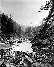
formation to form the Tallulah Gorge
and its several waterfall
s (collectively known as Tallulah Falls
). The Tallulah River intersects with the Chattooga River
to form the Tugaloo River
at Lake Tugalo
in Habersham County, which then joins South Carolina
's Seneca River at Lake Hartwell
to create the Savannah River
which flows southeastward into the Atlantic Ocean
.
From its headwaters to its confluence
with the Tugaloo River, the Tallulah River is approximately 48 miles (77.2 km) long. The Tallulah River Basin drains approximately 184 square miles (476.6 km²), as measured at the Tallulah Falls Hydroelectric Plant in Habersham County, Georgia
, near the lower end of the Tallulah Gorge. The lower part of the river includes a string of man-made lakes along the river created by hydroelectric dams operated by Georgia Power
. The first (and northernmost) lake in the series is Lake Burton
, which is followed by Lake Seed
, Lake Rabun
, and Lake Tallulah Falls. From Tallulah Falls Lake, the lower part of the river flows through the Tallulah Gorge and now ends as an arm of Lake Tugalo
, the other arm of the lake being formed by the Chattooga River
. Starting at a point about 0.5 mile (0.80467 km) downstream from the dam for Tallulah Falls Lake
, the boundary line between Habersham and Rabun counties follows the course of the Tallulah River to its end.
 The upper Tallulah River Basin drains to the portion of the Tallulah River that is upstream from Lake Burton and includes northwestern Rabun County, northeastern Towns County and part of Clay County, North Carolina. The United States Geological Survey
collects data for the upper Tallulah River Basin from its gauging station at the point where the river crosses Plum Orchard Road. The upper Tallulah River Basin includes a section of the river that is about 14.3 miles (23 km) long, draining a 56.5 square mile (146 km²) area. Annually, the area receives at least 72 inches of rainfall and is entirely within the boundaries of the Chattahoochee National Forest, with about one third of the land falling in the Southern Nantahala Wilderness
and about one fifth privately owned. The primary tributaries of the Tallulah River in Rabun County are Coleman River
and Persimmon Creek.
 The upper Tallulah River Basin is as scenic as it is rugged. The highest elevations are found in North Carolina on Standing Indian Mountain
, elevation 5,499 feet, where the Tallulah River headwaters are located. After coming into Georgia and passing through the old mining and logging town of Tate City, Georgia
in eastern Towns County, the river enters into to what some people call Tallulah’s upper gorge or the Rock Mountain Gorge. This upper "gorge" is far less dramatic that the more famous Tallulah Gorge, but it starts just upstream from the river’s confluence with Coleman River and runs nearly 3 miles (5 km) past Rock Mountain
on the western side of the river. The scenic "gorge" is accessible via a drive along the Tallulah River Road (Forest Service Road 70). The Tallulah River Road follows an old railroad bed before ending in the Southern Nantahala Wilderness and provides the only access to Tate City. Heavily wooded today, the upper Tallulah River Basin was stripped nearly bare by logging in the 1930s before the establishment of the Chattahoochee National Forest.
Because Georgians long have assumed that Tallulah was a Cherokee word, there is no agreement regarding the derivation of the name for the Tallulah River. Tourism promoters in the late 19th century described the word Tallulah as meaning "thundering waters" in Cherokee. Some scholars later theorized the that tallulah meant “terrible” in Cherokee
or was possibly derived from a number of other words, but it is more likely that there is no translation for the word. It actually has no meaning in Cherokee. The most likely source of the word is the Okonee (a branch of the Creek Indians) word talula, which means "town". The Okonee People occupied northeastern Georgia and northwestern South Carolina for hundreds of years prior to the arrival of the Cherokees in the early 18th century.
In any event, there was a Cherokee Over-the-Hill settlement called Tallulah located on the upper portion of the river.
River
A river is a natural watercourse, usually freshwater, flowing towards an ocean, a lake, a sea, or another river. In a few cases, a river simply flows into the ground or dries up completely before reaching another body of water. Small rivers may also be called by several other names, including...
in Georgia
Georgia (U.S. state)
Georgia is a state located in the southeastern United States. It was established in 1732, the last of the original Thirteen Colonies. The state is named after King George II of Great Britain. Georgia was the fourth state to ratify the United States Constitution, on January 2, 1788...
and North Carolina
North Carolina
North Carolina is a state located in the southeastern United States. The state borders South Carolina and Georgia to the south, Tennessee to the west and Virginia to the north. North Carolina contains 100 counties. Its capital is Raleigh, and its largest city is Charlotte...
. It begins in Clay County, North Carolina
Clay County, North Carolina
-Communities and Townships:Hayesville, with a 2000 population of 297, is the only incorporated town in the county, the county seat, and center of economic activity for Clay County...
, near Standing Indian Mountain
Standing Indian Mountain
Standing Indian Mountain, elevation 5,499 feet, is part of the North Carolina portion of the Southern Nantahala Wilderness within the boundaries of the Nantahala National Forest...
in the Southern Nantahala Wilderness
Southern Nantahala Wilderness
The Southern Nantahala Wilderness was designated in 1984 and currently consists of . Approximately are located in Georgia in the Chattahoochee National Forest and approximately are located in North Carolina in the Nantahala National Forest. The Wilderness is managed by the United States Forest...
and flows south into Georgia, crossing the state line into Towns County
Towns County, Georgia
Towns County is a county located in the U.S. state of Georgia. It was created on March 6, 1856. As of the 2000 census, the population was 9,319. The 2007 Census Estimate shows a population of 10,894. Its county seat is Hiawassee.-History:...
. The river then travels through Rabun County
Rabun County, Georgia
Rabun County is a county located in the U.S. state of Georgia. As of the 2000 census, the population was 15,050. The 2007 Census Estimate shows a population of 16,519...
and ends in Habersham County
Habersham County, Georgia
Habersham County is a county located in the U.S. state of Georgia. It was created on December 15, 1818, and named for Colonel Joseph Habersham. As of 2000, the population was 35,902. The 2007 Census Estimate shows a population of 42,272. Clarkesville is the county seat.Chartered in 1823, the...
. It cuts through the Tallulah Dome rock
Rock (geology)
In geology, rock or stone is a naturally occurring solid aggregate of minerals and/or mineraloids.The Earth's outer solid layer, the lithosphere, is made of rock. In general rocks are of three types, namely, igneous, sedimentary, and metamorphic...
formation to form the Tallulah Gorge
Tallulah Gorge
The Tallulah Gorge is a gorge that is formed by the Tallulah River cutting through the Tallulah Dome rock formation. The gorge is approximately long and features rocky cliffs up to high. Through it, a series of falls known as Tallulah Falls, drop a total of in one mile...
and its several waterfall
Waterfall
A waterfall is a place where flowing water rapidly drops in elevation as it flows over a steep region or a cliff.-Formation:Waterfalls are commonly formed when a river is young. At these times the channel is often narrow and deep. When the river courses over resistant bedrock, erosion happens...
s (collectively known as Tallulah Falls
Tallulah Gorge
The Tallulah Gorge is a gorge that is formed by the Tallulah River cutting through the Tallulah Dome rock formation. The gorge is approximately long and features rocky cliffs up to high. Through it, a series of falls known as Tallulah Falls, drop a total of in one mile...
). The Tallulah River intersects with the Chattooga River
Chattooga River
The Chattooga River is the main tributary of the Tugaloo River. Its headwaters are located southwest of Cashiers, North Carolina, and it stretches to where it has its confluence with the Tallulah River within Lake Tugalo, held back by the Tugalo Dam...
to form the Tugaloo River
Tugaloo River
The Tugaloo River is a river bordering the U.S. states of Georgia and South Carolina. It is fed by the Tallulah River and the Chattooga River, which each form an arm of Lake Tugalo, on the edge of Georgia's Tallulah Gorge State Park. The Tugaloo then flows out of the lake via Tugaloo Dam,...
at Lake Tugalo
Lake Tugalo
Lake Tugalo is a reservoir with of shoreline located in the northeastern Georgia in Habersham and Rabun counties, but also lies partially in Oconee County, South Carolina. It is the fifth lake in a six-lake series created by hydroelectric dams operated by Georgia Power that follows the original...
in Habersham County, which then joins South Carolina
South Carolina
South Carolina is a state in the Deep South of the United States that borders Georgia to the south, North Carolina to the north, and the Atlantic Ocean to the east. Originally part of the Province of Carolina, the Province of South Carolina was one of the 13 colonies that declared independence...
's Seneca River at Lake Hartwell
Lake Hartwell
Lake Hartwell is a reservoir bordering Georgia and South Carolina on the Savannah, Tugaloo, and Seneca Rivers. The lake is created by Hartwell Dam located on the Savannah River seven miles below the point at which the Tugaloo and Seneca Rivers join to form the Savannah...
to create the Savannah River
Savannah River
The Savannah River is a major river in the southeastern United States, forming most of the border between the states of South Carolina and Georgia. Two tributaries of the Savannah, the Tugaloo River and the Chattooga River, form the northernmost part of the border...
which flows southeastward into the Atlantic Ocean
Atlantic Ocean
The Atlantic Ocean is the second-largest of the world's oceanic divisions. With a total area of about , it covers approximately 20% of the Earth's surface and about 26% of its water surface area...
.
From its headwaters to its confluence
Confluence
Confluence, in geography, describes the meeting of two or more bodies of water.Confluence may also refer to:* Confluence , a property of term rewriting systems...
with the Tugaloo River, the Tallulah River is approximately 48 miles (77.2 km) long. The Tallulah River Basin drains approximately 184 square miles (476.6 km²), as measured at the Tallulah Falls Hydroelectric Plant in Habersham County, Georgia
Habersham County, Georgia
Habersham County is a county located in the U.S. state of Georgia. It was created on December 15, 1818, and named for Colonel Joseph Habersham. As of 2000, the population was 35,902. The 2007 Census Estimate shows a population of 42,272. Clarkesville is the county seat.Chartered in 1823, the...
, near the lower end of the Tallulah Gorge. The lower part of the river includes a string of man-made lakes along the river created by hydroelectric dams operated by Georgia Power
Georgia Power
Georgia Power is an electric utility headquartered in Atlanta, Georgia, United States. It is the largest of the four electric utilities that are owned and operated by Southern Company....
. The first (and northernmost) lake in the series is Lake Burton
Lake Burton (Georgia)
Lake Burton is a 2,775 acre reservoir with 62 miles of shoreline located in the northeastern corner of Georgia in Rabun County. It is the first lake in a six-lake series called the Tallulah River Watershed that follows the original course of the Tallulah River...
, which is followed by Lake Seed
Lake Seed
Lake Seed is a 240 acre reservoir with 13 miles of shoreline located in Rabun County, in the northeastern corner of Georgia, USA. It is the second lake in a series of six lakes that follow the original riverbed of the Tallulah River. Each lake in the chain is created by hydroelectric dams...
, Lake Rabun
Lake Rabun
Lake Rabun is a twisty reservoir with of shoreline located in the Northeastern corner of Georgia in Rabun County. It is the third lake in a six-lake series that follows the original course of the Tallulah River. The series begins with Lake Burton as the northernmost lake, followed by Lake Seed,...
, and Lake Tallulah Falls. From Tallulah Falls Lake, the lower part of the river flows through the Tallulah Gorge and now ends as an arm of Lake Tugalo
Lake Tugalo
Lake Tugalo is a reservoir with of shoreline located in the northeastern Georgia in Habersham and Rabun counties, but also lies partially in Oconee County, South Carolina. It is the fifth lake in a six-lake series created by hydroelectric dams operated by Georgia Power that follows the original...
, the other arm of the lake being formed by the Chattooga River
Chattooga River
The Chattooga River is the main tributary of the Tugaloo River. Its headwaters are located southwest of Cashiers, North Carolina, and it stretches to where it has its confluence with the Tallulah River within Lake Tugalo, held back by the Tugalo Dam...
. Starting at a point about 0.5 mile (0.80467 km) downstream from the dam for Tallulah Falls Lake
Tallulah Falls Lake
Tallulah Falls Lake is a reservoir with of shoreline located in the Northeastern corner of Georgia in Rabun County. It is the fourth and smallest lake in a six-lake series created by hydroelectric dams operated by Georgia Power that follows the original course of the Tallulah River...
, the boundary line between Habersham and Rabun counties follows the course of the Tallulah River to its end.
United States Geological Survey
The United States Geological Survey is a scientific agency of the United States government. The scientists of the USGS study the landscape of the United States, its natural resources, and the natural hazards that threaten it. The organization has four major science disciplines, concerning biology,...
collects data for the upper Tallulah River Basin from its gauging station at the point where the river crosses Plum Orchard Road. The upper Tallulah River Basin includes a section of the river that is about 14.3 miles (23 km) long, draining a 56.5 square mile (146 km²) area. Annually, the area receives at least 72 inches of rainfall and is entirely within the boundaries of the Chattahoochee National Forest, with about one third of the land falling in the Southern Nantahala Wilderness
Southern Nantahala Wilderness
The Southern Nantahala Wilderness was designated in 1984 and currently consists of . Approximately are located in Georgia in the Chattahoochee National Forest and approximately are located in North Carolina in the Nantahala National Forest. The Wilderness is managed by the United States Forest...
and about one fifth privately owned. The primary tributaries of the Tallulah River in Rabun County are Coleman River
Coleman River
Coleman River is a stream that is located in the Blue Ridge Mountains, mostly within Rabun County, Georgia. It is one of the main tributaries of the Tallulah River. The headwaters of Coleman River are located in Clay County, North Carolina, and the river travels a short distance before crossing...
and Persimmon Creek.
Standing Indian Mountain
Standing Indian Mountain, elevation 5,499 feet, is part of the North Carolina portion of the Southern Nantahala Wilderness within the boundaries of the Nantahala National Forest...
, elevation 5,499 feet, where the Tallulah River headwaters are located. After coming into Georgia and passing through the old mining and logging town of Tate City, Georgia
Tate City, Georgia
Tate City is an unincorporated community in Towns County, Georgia, United States. It was founded as a mining and logging community.Tate City sits in a scenic valley along the upper Tallulah River, just south of the Georgia-North Carolina border. The community is flanked by various peaks of the...
in eastern Towns County, the river enters into to what some people call Tallulah’s upper gorge or the Rock Mountain Gorge. This upper "gorge" is far less dramatic that the more famous Tallulah Gorge, but it starts just upstream from the river’s confluence with Coleman River and runs nearly 3 miles (5 km) past Rock Mountain
Rock Mountain (Georgia)
Rock Mountain is a name used to describe two different mountains located in the North Georgia mountains that are in two different Georgia counties.-Floyd County:* Rock Mountain is a mountain located west of Armuchee, Georgia.-Rabun County:...
on the western side of the river. The scenic "gorge" is accessible via a drive along the Tallulah River Road (Forest Service Road 70). The Tallulah River Road follows an old railroad bed before ending in the Southern Nantahala Wilderness and provides the only access to Tate City. Heavily wooded today, the upper Tallulah River Basin was stripped nearly bare by logging in the 1930s before the establishment of the Chattahoochee National Forest.
Because Georgians long have assumed that Tallulah was a Cherokee word, there is no agreement regarding the derivation of the name for the Tallulah River. Tourism promoters in the late 19th century described the word Tallulah as meaning "thundering waters" in Cherokee. Some scholars later theorized the that tallulah meant “terrible” in Cherokee
Cherokee language
Cherokee is an Iroquoian language spoken by the Cherokee people which uses a unique syllabary writing system. It is the only Southern Iroquoian language that remains spoken. Cherokee is a polysynthetic language.-North American etymology:...
or was possibly derived from a number of other words, but it is more likely that there is no translation for the word. It actually has no meaning in Cherokee. The most likely source of the word is the Okonee (a branch of the Creek Indians) word talula, which means "town". The Okonee People occupied northeastern Georgia and northwestern South Carolina for hundreds of years prior to the arrival of the Cherokees in the early 18th century.
In any event, there was a Cherokee Over-the-Hill settlement called Tallulah located on the upper portion of the river.