

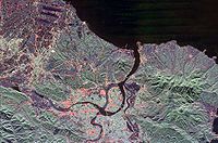
Taipei Basin
Encyclopedia
Taiwan
Taiwan , also known, especially in the past, as Formosa , is the largest island of the same-named island group of East Asia in the western Pacific Ocean and located off the southeastern coast of mainland China. The island forms over 99% of the current territory of the Republic of China following...
. It is the second largest basin in Taiwan. The basin is bounded by Yangmingshan
Yangmingshan
One of the eight national parks in Taiwan, the Yangmingshan National Park is located between Taipei City and New Taipei City, Taiwan. The districts that house parts of the park grounds include Taipei's Beitou and Shilin Districts; and New Taipei's Wanli, Jinshan, and Sanzhi Districts. During the...
to the north, Linkou mesa
Mesa
A mesa or table mountain is an elevated area of land with a flat top and sides that are usually steep cliffs. It takes its name from its characteristic table-top shape....
to the west, and the Ridge of Xueshan Range (Traditional Chinese: 雪山山脈) to the southeast. The shape of the basin is close to a triangle. The three vertices are Nangang, Huilong of Xinzhuang
Xinzhuang, Taiwan
Xinzhuang District is a district in the western part of New Taipei in northern Republic of China . It has an area of and a population of 388,110 people ....
, and Guandu of Beitou
Beitou
Beitou District is the northernmost of the twelve districts of Taipei City, Taiwan. The historical spelling of the district is Peitou. The name originates from the Ketagalan word Kipatauw, meaning witch. Beitou is the most mountainous and highest of Taipei's districts.Beitou is famous for its hot...
.
The main rivers in Taipei Basin include Tamsui River, Keelung River
Keelung River
Keelung River is a river in northern Taiwan.The Keelung River originates in the mountains west-northwest of the town of Jingtong in Pingxi District, New Taipei City, flows down to a rift valley and then flows ENE to Sandiaoling...
, Dahan River, and Xindian River
Xindian River
The Xindian River is a river in northern Taiwan. It flows through New Taipei and the capital Taipei for 82 km. The Feitsui Dam spans the river southeast of Taipei.-Overview:...
.
In the prehistoric era, Taipei Basin was home to Ketagalan tribes. Han Chinese
Han Chinese
Han Chinese are an ethnic group native to China and are the largest single ethnic group in the world.Han Chinese constitute about 92% of the population of the People's Republic of China , 98% of the population of the Republic of China , 78% of the population of Singapore, and about 20% of the...
did not settle in the region until the 18th century. Today, Taipei Basin is within the boundaries of Taipei City and New Taipei City and is the largest metropolitan area in Taiwan
Taiwan
Taiwan , also known, especially in the past, as Formosa , is the largest island of the same-named island group of East Asia in the western Pacific Ocean and located off the southeastern coast of mainland China. The island forms over 99% of the current territory of the Republic of China following...
.