
Table Rock Lake
Encyclopedia
Table Rock Lake is an artificial lake or reservoir
in The Ozarks
of southwestern Missouri
and northwestern Arkansas
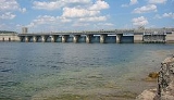
. It is impounded by Table Rock Dam
constructed in 1954-1958 on the White River
by the U.S. Army Corps of Engineers. It is one of the tourist
draws for the nearby town of Branson, Missouri
. There are several commercial marinas along the lake, and Table Rock State Park
is located on the east side both north and south of Table Rock Dam. Downstream from the dam, the Missouri Department of Conservation
operates a fish hatchery
, which is used to stock trout
in Lake Taneycomo
. The cold water discharged from the dam creates a trout fishing environment in Lake Taneycomo.
Dam elevations above mean sea level
Lake elevations above mean sea level
Surface area of lake
Maximum storage capacity
Shoreline length
Other
Power generating data
Reservoir
A reservoir , artificial lake or dam is used to store water.Reservoirs may be created in river valleys by the construction of a dam or may be built by excavation in the ground or by conventional construction techniques such as brickwork or cast concrete.The term reservoir may also be used to...
in The Ozarks
The Ozarks
The Ozarks are a physiographic and geologic highland region of the central United States. It covers much of the southern half of Missouri and an extensive portion of northwestern and north central Arkansas...
of southwestern Missouri
Missouri
Missouri is a US state located in the Midwestern United States, bordered by Iowa, Illinois, Kentucky, Tennessee, Arkansas, Oklahoma, Kansas and Nebraska. With a 2010 population of 5,988,927, Missouri is the 18th most populous state in the nation and the fifth most populous in the Midwest. It...
and northwestern Arkansas
Arkansas
Arkansas is a state located in the southern region of the United States. Its name is an Algonquian name of the Quapaw Indians. Arkansas shares borders with six states , and its eastern border is largely defined by the Mississippi River...
. It is impounded by Table Rock Dam
Dam
A dam is a barrier that impounds water or underground streams. Dams generally serve the primary purpose of retaining water, while other structures such as floodgates or levees are used to manage or prevent water flow into specific land regions. Hydropower and pumped-storage hydroelectricity are...
constructed in 1954-1958 on the White River
White River (Arkansas)
The White River is a 722-mile long river that flows through the U.S. states of Arkansas and Missouri.-Course:The source of the White River is in the Boston Mountains of northwest Arkansas, in the Ozark-St. Francis National Forest southeast of Fayetteville...
by the U.S. Army Corps of Engineers. It is one of the tourist
Tourism
Tourism is travel for recreational, leisure or business purposes. The World Tourism Organization defines tourists as people "traveling to and staying in places outside their usual environment for not more than one consecutive year for leisure, business and other purposes".Tourism has become a...
draws for the nearby town of Branson, Missouri
Branson, Missouri
Branson is a city in Taney County in the U.S. state of Missouri. It was named after Reuben Branson, postmaster and operator of a general store in the area in the 1880s....
. There are several commercial marinas along the lake, and Table Rock State Park
Table Rock State Park (Missouri)
Table Rock State Park is a state park in the US state of Missouri consisting of located in Taney County and Stone County on Table Rock Lake....
is located on the east side both north and south of Table Rock Dam. Downstream from the dam, the Missouri Department of Conservation
Missouri Department of Conservation
The Missouri Department of Conservation and the Missouri Conservation Commission were created by Article IV Sections 40-42 of the Missouri Constitution, which were adopted by the voters of the state in 1936 as Amendment 4 to the constitution...
operates a fish hatchery
Fish hatchery
A fish hatchery is a "place for artificial breeding, hatching and rearing through the early life stages of animals, finfish and shellfish in particular". Hatcheries produce larval and juvenile fish primarily to support the aquaculture industry where they are transferred to on-growing systems...
, which is used to stock trout
Trout
Trout is the name for a number of species of freshwater and saltwater fish belonging to the Salmoninae subfamily of the family Salmonidae. Salmon belong to the same family as trout. Most salmon species spend almost all their lives in salt water...
in Lake Taneycomo
Lake Taneycomo
Lake Taneycomo is a man-made lake or reservoir on the White River in the Ozark Mountains of Taney County, Missouri. The reservoir is named for the county in which it is located: Taney County, MO....
. The cold water discharged from the dam creates a trout fishing environment in Lake Taneycomo.
Lake air temperature
The lake area temperature varies according to season:- Spring: 56 to 77 °F (25 °C)
- Summer: 85 to 90 °F (32.2 °C)
- Fall: 71 to 82 °F (27.8 °C)
- Winter: 42 to 47 °F (8.3 °C)
Lake data
Dam and Outlet Measurements- Length of dam- 6423 feet (1,957.7 m)
- Length of concrete section- 1602 feet (488.3 m)
- Maximum height of dam above stream bed- 252 feet (76.8 m)
- Concrete in dam- 1,230,000 cubic yards
- Earth in embankment- 3,320,000 cubic yards
- Length of spillway- 531 gross feet
- Spillway crest gates size- 45x37 feet
- Outlet conduits size- 4x9 feet
Dam elevations above mean sea level
- Top of dam- 947 feet (288.6 m)
- Spillway crest- 896 feet (273.1 m)
Lake elevations above mean sea level
- Top of flood control pool- 931 feet (283.8 m)
- Top of normal pool- 915 feet (278.9 m)
Surface area of lake
- Flood control pool- 52300 acres (212 km²)
- Normal pool- 43100 acres (174 km²)
Maximum storage capacity
- Flood control pool- 760000 acre.ft
Shoreline length
- Flood control pool- 857 miles (1,379.2 km)
- Normal Pool- 745 miles (1,199 km)
Other
- Power drawdown and dead- 2,702,000
- Lake total- 3,462,000
Power generating data
- Number of generating units- 4
- Rated capacity for each unit- 50,000 kilowatts
- Station installed capacity- 200,000 kilowatts
Flood control
The original purpose of the reservoir was for flood control on the White River. The dam had been authorized a month earlier under the Flood Control Act of September 3, 1943. The reservoir has a fluctuation of 16 feet (4.9 m). When the reservoir is above the maximum flood pool, excess water goes over the auxiliary overflow spillway at the north end of the dam.Further reading
- "Wake Up to Table Rock Lake", pamphlet available at the Table Rock Dam Visitors' Center