
Swanton Novers
Encyclopedia
Swanton Novers is a village and a civil parish
in the English
county of Norfolk
. The village is 15.1 miles (24.3 km) west-south-west of Cromer
, 23.1 miles (37.2 km) north-north-west of Norwich
and 123 kilometres (76.4 mi) north-north-east of London
. The village lies 6 miles (9.7 km) south-west of the town of Holt
. The nearest railway station is at Sheringham
for the Bittern Line
which runs between Sheringham
, Cromer
and Norwich. The nearest airport is Norwich International Airport
.
of 1086, in which the village is recorded by the name Suanetuna. The main tenant was Bishop William. The survey also notes that there were 200 sheep. The name Suanetuna means 'town or settlement of the swine-herds'. The land was held by Milo de Nuiers in 1200. This name derives from Noyers-Bocage in Normandy
.
is a little remote from the village. The church has been heavily restored in recent times as it was in a very poor state of repair. The church's tower was rebuilt in 1821. Much of the restoration work has been carried out using old building materials from the original church buildings which dates from Norman
times.
Civil parish
In England, a civil parish is a territorial designation and, where they are found, the lowest tier of local government below districts and counties...
in the English
England
England is a country that is part of the United Kingdom. It shares land borders with Scotland to the north and Wales to the west; the Irish Sea is to the north west, the Celtic Sea to the south west, with the North Sea to the east and the English Channel to the south separating it from continental...
county of Norfolk
Norfolk
Norfolk is a low-lying county in the East of England. It has borders with Lincolnshire to the west, Cambridgeshire to the west and southwest and Suffolk to the south. Its northern and eastern boundaries are the North Sea coast and to the north-west the county is bordered by The Wash. The county...
. The village is 15.1 miles (24.3 km) west-south-west of Cromer
Cromer
Cromer is a coastal town and civil parish in north Norfolk, England. The local government authority is North Norfolk District Council, whose headquarters is in Holt Road in the town. The town is situated 23 miles north of the county town, Norwich, and is 4 miles east of Sheringham...
, 23.1 miles (37.2 km) north-north-west of Norwich
Norwich
Norwich is a city in England. It is the regional administrative centre and county town of Norfolk. During the 11th century, Norwich was the largest city in England after London, and one of the most important places in the kingdom...
and 123 kilometres (76.4 mi) north-north-east of London
London
London is the capital city of :England and the :United Kingdom, the largest metropolitan area in the United Kingdom, and the largest urban zone in the European Union by most measures. Located on the River Thames, London has been a major settlement for two millennia, its history going back to its...
. The village lies 6 miles (9.7 km) south-west of the town of Holt
Holt, Norfolk
Holt is a market town and civil parish in the English county of Norfolk. The town is north of the city of Norwich, west of Cromer and east of King's Lynn. The town is on the route of the A148 King's Lynn to Cromer road. The nearest railway station is in the town of Sheringham where access to the...
. The nearest railway station is at Sheringham
Sheringham railway station
Sheringham railway station is a timber halt in the town of Sheringham in the English county of Norfolk. The station is the terminus of the Bittern Line, operated by National Express East Anglia, and is 49 km north of...
for the Bittern Line
Bittern Line
The Bittern Line is a railway line from Norwich to Cromer then Sheringham in Norfolk, England. It is one of the most scenic in the East of England traversing the Norfolk Broads on its route to the Area of Outstanding Natural Beauty on the North Norfolk Coast. The line is part of the Network Rail...
which runs between Sheringham
Sheringham
Sheringham is a seaside town in Norfolk, England, west of Cromer.The motto of the town, granted in 1953 to the Sheringham Urban District Council, is Mare Ditat Pinusque Decorat, Latin for "The sea enriches and the pine adorns"....
, Cromer
Cromer
Cromer is a coastal town and civil parish in north Norfolk, England. The local government authority is North Norfolk District Council, whose headquarters is in Holt Road in the town. The town is situated 23 miles north of the county town, Norwich, and is 4 miles east of Sheringham...
and Norwich. The nearest airport is Norwich International Airport
Norwich International Airport
Norwich International Airport , also known as Norwich Airport, is an airport in the City of Norwich within Norfolk, England north of the city centre and on the edge of the city's suburbs....
.
History
Swanton Novers has an entry in the Domesday BookDomesday Book
Domesday Book , now held at The National Archives, Kew, Richmond upon Thames in South West London, is the record of the great survey of much of England and parts of Wales completed in 1086...
of 1086, in which the village is recorded by the name Suanetuna. The main tenant was Bishop William. The survey also notes that there were 200 sheep. The name Suanetuna means 'town or settlement of the swine-herds'. The land was held by Milo de Nuiers in 1200. This name derives from Noyers-Bocage in Normandy
Normandy
Normandy is a geographical region corresponding to the former Duchy of Normandy. It is in France.The continental territory covers 30,627 km² and forms the preponderant part of Normandy and roughly 5% of the territory of France. It is divided for administrative purposes into two régions:...
.
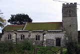
St Edmund's Church
St Edmund's parish churchParish church
A parish church , in Christianity, is the church which acts as the religious centre of a parish, the basic administrative unit of episcopal churches....
is a little remote from the village. The church has been heavily restored in recent times as it was in a very poor state of repair. The church's tower was rebuilt in 1821. Much of the restoration work has been carried out using old building materials from the original church buildings which dates from Norman
Normans
The Normans were the people who gave their name to Normandy, a region in northern France. They were descended from Norse Viking conquerors of the territory and the native population of Frankish and Gallo-Roman stock...
times.