
Sumgal
Encyclopedia

Ladakh
Ladakh is a region of Jammu and Kashmir, the northernmost state of the Republic of India. It lies between the Kunlun mountain range in the north and the main Great Himalayas to the south, inhabited by people of Indo-Aryan and Tibetan descent...
region of Xinjiang
Xinjiang
Xinjiang is an autonomous region of the People's Republic of China. It is the largest Chinese administrative division and spans over 1.6 million km2...
, China. In 1857, the explorer Robert Schlagintweit crossed the Hindutash
Hindutash
Hindutash, also known as Hindu-tagh Pass, is a historical mountain pass in the western Xinjiang Uyghur Autonomous Region of the People's Republic of China...
pass from the camping grounds in Sumgal ( from Gsum Rgal meaning "three fords" in Ladakhi ), on the banks of the Karakash river, approximately 7 miles upstream from Sumgal in Ladakh and estimated its height to be 17,879 feet.
The pass cuts through the Kun Lun mountain range connecting Sumgal, (36° 11' 58 N, 78° 46' 50 E) in the Karakash River
Karakash River
The Karakash or Black Jade River, also spelled Karakax , is a river in the Xinjiang autonomous region of the People's Republic of China, which lies partially in the disputed Aksai Chin region. The river originates near Sumde on the northern slopes of the Karakoram range in the Aksai Chin region of...
valley to the town of Pusha, (36.3833° N, 79° E), formerly Bushia, in the Yurungkash River valley, in the territory of Khotan
Khotan
Hotan , or Hetian , also spelled Khotan, is the seat of the Hotan Prefecture in Xinjiang, China. It was previously known in Chinese as 于窴/於窴 and to 19th-century European explorers as Ilchi....
and also connects to the road to the city of Khotan
Khotan
Hotan , or Hetian , also spelled Khotan, is the seat of the Hotan Prefecture in Xinjiang, China. It was previously known in Chinese as 于窴/於窴 and to 19th-century European explorers as Ilchi....
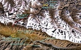
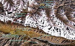
. (See maps on right.) At the top of the Hindutash pass (36° 16' 23 N, 78° 46' 50 E), there is a steep glacier with many crevasses.
The eastern Kunlun range, which is in the southern border of the Khotan, is cut by two other passes: the Sanju Pass near the town of Shahidulla, where the Maharaja of Kashmir had built a fort in exercise of his sovereignty in that area of Kashmir northwest of Hindutash, and the Yangi or Ilchi Pass, southeast of Hindutash in the northern part of the Aksai Chin area in Ladakh (see second map on right). The Hindutash pass has been used historically as the point of entry into India Proper from the ancient Indian Kingdom of Khotan which only explains the literal meaning of the name Hindutash signifying border post.
The latter was traversed in 1865 by W. H. Johnson of the Survey of India. W.H. Johnson’s survey established certain important points. Brinjga was in his view the boundary post (a few miles south east of Karanghu Tagh in Ladakh), thus implying that the boundary lay along the Kuen Lun Range. Johnson’s findings demonstrated that the whole of the Kara Kash valley was an integral part of the territory of Kashmir. He noted where the Chinese boundary post was accepted. At Yangi Langar, three marches from Khotan, he noticed that there was a few fruit trees at this place which originally was a post or guard house of the Chinese.
According to Johnson, “the last portion of the route to Shadulla (Shahidulla) ( which includes the Sumgal area) is particularly pleasant, being the whole of the Karakash valley which is wide and even, and shut in either side by rugged mountains. On this route I noticed numerous extensive plateaux near the river, covered with wood and long grass. These being within the territory of the Maharaja of Kashmir, could easily be brought under cultivation by Ladakhees and others, if they could be induced and encouraged to do so by the Kashmeer Government. The establishment of villages and habitations on this river would be important in many points of view, but chiefly in keeping the route open from the attacks of the Khergiz robbers.” "Hindu-tagh" means "Indian Mountain," and "Hindu-tash," "Indian stone" in the Uyghur dialect
Uyghur language
Uyghur , formerly known as Eastern Turk, is a Turkic language with 8 to 11 million speakers, spoken primarily by the Uyghur people in the Xinjiang Uyghur Autonomous Region of Western China. Significant communities of Uyghur-speakers are located in Kazakhstan and Uzbekistan, and various other...
of East Turkistan.
Gallery
Image:Chain-of-kuenluen-from-sumgal1857a.jpg|"The Chain of the Kuenlúen, from Súmgal, in Ladakh (Lat North 36° 8', Long. East of Green. 78° 5', Height 13, 215 Engl. feet)" by Hermann Schlagintweit
Hermann Schlagintweit
Hermann Schlagintweit, Sakünlünski , also known as Hermann Rudolph Alfred von Schlagintweit-Sakünlünski, was a German explorer of Central Asia....
, August 1856. Lithographed by Sabatier, printed in oil-colours by Lemereier, Paris. The Hindu-tagh Pass is the break in the mountains on the right.
Image:Karakash_River_in_the_Western_Kunlun_Shan,_seen_from_the_Tibet-Xinjiang_highway.jpg|Karakash River in the Western Kunlun Range, seen from the Pan- Kashmir Highway
Image:Kunlun_IMG_0541.jpg|View of Western Kunlun Range from the Pan- Kashmir Highway
Maps
Image:NWFP-Kashmir1909-a.jpg|A lower-resolution 1909 Map of the Princely State of Kashmir and Jammu. Sumgal at the base of the Hindutash Pass, Ladakh
Ladakh
Ladakh is a region of Jammu and Kashmir, the northernmost state of the Republic of India. It lies between the Kunlun mountain range in the north and the main Great Himalayas to the south, inhabited by people of Indo-Aryan and Tibetan descent...
, Kashmir
Kashmir
Kashmir is the northwestern region of the Indian subcontinent. Until the mid-19th century, the term Kashmir geographically denoted only the valley between the Great Himalayas and the Pir Panjal mountain range...
is shown in the top right corner.
Image:Yangi-hindutash-aurel-stein-map-1911.jpg|Map of Aurel Stein (1911) based on that of the Survey of India showing the "Hindutash Dawan" in the Kunlun Mountains in Ladakh
Ladakh
Ladakh is a region of Jammu and Kashmir, the northernmost state of the Republic of India. It lies between the Kunlun mountain range in the north and the main Great Himalayas to the south, inhabited by people of Indo-Aryan and Tibetan descent...
Image:Johnson-journey-ilchi1865-mapa.jpg|Map of W. H. Johnson showing the route of his trip to Khotan from Leh; in this map, Johnson refers to the pass as "Hindotak diwan Pass." He himself traveled through the Yangi diwan Pass, some 20 miles up-river from Hindutash, on his outward journey, and returned via the Sanju diwan Pass near Shahdula. Johnson placed the border of Kashmir with Turkistan at Bringja. (Refer accompanying maps for position of Bringja) The Map unequivocally and with out an iota of doubt depicts Hindutash pass as part of Kashmir.
See also
- KashmirKashmirKashmir is the northwestern region of the Indian subcontinent. Until the mid-19th century, the term Kashmir geographically denoted only the valley between the Great Himalayas and the Pir Panjal mountain range...
- Aksai ChinAksai ChinAksai Chin is one of the two main disputed border areas between China and India, and the other is South Tibet, which comprises most of India's Arunachal Pradesh. It is administered by China as part of Hotan County in the Hotan Prefecture of Xinjiang Autonomous Region, but is also claimed by India...
- Kunlun MountainsKunlun MountainsThe Kunlun Mountains are one of the longest mountain chains in Asia, extending more than 3,000 km. In the broadest sense, it forms the northern edge of the Tibetan Plateau south of the Tarim Basin and the Gansu Corridor and continues east south of the Wei River to end at the North China Plain.The...
- Yurungkash
- Karakash RiverKarakash RiverThe Karakash or Black Jade River, also spelled Karakax , is a river in the Xinjiang autonomous region of the People's Republic of China, which lies partially in the disputed Aksai Chin region. The river originates near Sumde on the northern slopes of the Karakoram range in the Aksai Chin region of...
- Indian Sub-continent
General sources
.....- Gazetteer of Kashmir and Ladak compiled under the direction of the Quarter Master | General in India in the Intelligence Branch. First Published in 1890 by the Superintendent of Government Printing, Calcutta. Compiled under the Direction of the Quartermaster -General in India in the Intelligence | Branch. 1890 Ed.
- Report of the Great Trigonometrical Survey of India, 1866, p. 6.
- Map referred to in Art.9 of the Simla Convention between Great Britain, China and Tibet, 1914 signed by the Chinese representative.
- Atlas of the northern frontiers of India . Pg.20
- Himalayan Frontiers by Dorothy Woodman. Pg.67-68