
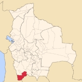
Sud Lípez Province
Encyclopedia
Sur Lípez is a province
in the Potosí Department
in Bolivia
. The seat of the province is San Pablo de Lípez
.
, 67° 52' 35.004" West
, at an elevation of approximately 5,400 on the northeastern slope of the Licancabur
volcano.
It is bordered by the Nor Lípez Province
in the north and northwest, Enrique Baldivieso Province
in the west, the Republic of Chile
in the southwest and south, the Republic of Argentina
in the southeast and east, and Sud Chichas Province
in the northeast.
The province extends from the northeast to the southwest, at a length of 230 km and an average width of 100 km.
, the largest being Laguna Colorada
, which is 6 km in diameter at an elevation of 4,278 m. Other lakes, such as Laguna Verde,
Laguna Blanca
and Laguna Celeste
are also well known for their respectively green, white and blue colors.
There is a geyser field called "Sol de Mañana
" in south-western Sur Lípez.
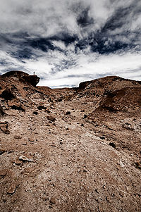
The tourist circuit La Ruta de las Joyas Altoandinas passes through the spectacular geography of this area.
which are further subdivided into cantons
.
99.4 % of the population have no access to electricity, 90 % have no sanitary facilities. 69 % of the population are employed in agriculture, 4 % in mining, 4 % in industry, 23 % in general services. 86 % of the population are Catholics, 9 % Protestants.
The people are predominantly indigenous
citizens of Quechua descent.
Provinces of Bolivia
A province is the second largest administrative division in Bolivia, after a department. Each department is divided into provinces. There are 112 provinces in total....
in the Potosí Department
Potosí Department
Potosí Department is a department in southwestern Bolivia. It comprises 118,218 km² with 709,013 inhabitants . The capital is the city of Potosí....
in Bolivia
Bolivia
Bolivia officially known as Plurinational State of Bolivia , is a landlocked country in central South America. It is the poorest country in South America...
. The seat of the province is San Pablo de Lípez
San Pablo de Lípez
San Pablo de Lípez is a small town in Bolivia.-References:...
.
Location
Sur Lípez is one of sixteen provinces in the Potosí Department. Also the southwesternmost point of Bolivia is located here, at 22° 49' 41.016" SouthLatitude
In geography, the latitude of a location on the Earth is the angular distance of that location south or north of the Equator. The latitude is an angle, and is usually measured in degrees . The equator has a latitude of 0°, the North pole has a latitude of 90° north , and the South pole has a...
, 67° 52' 35.004" West
Longitude
Longitude is a geographic coordinate that specifies the east-west position of a point on the Earth's surface. It is an angular measurement, usually expressed in degrees, minutes and seconds, and denoted by the Greek letter lambda ....
, at an elevation of approximately 5,400 on the northeastern slope of the Licancabur
Licancabur
Licancabur is a highly symmetrical stratovolcano on the southernmost part of the border between Chile and Bolivia. It is located just southwest of Laguna Verde in Bolivia. The volcano dominates the landscape of the Salar de Atacama area...
volcano.
It is bordered by the Nor Lípez Province
Nor Lípez Province
Nor Lípez is a province in the Bolivian department of Potosí. Its seat is Colcha "K", also called Villa Martín. The majority of the province's area was titled as the Nor Lípez Native Community Land on 19 April 2011...
in the north and northwest, Enrique Baldivieso Province
Enrique Baldivieso Province
Enrique Baldivieso is a province in the Bolivian department of Potosí. It is named after the former vice president Enrique Baldivieso...
in the west, the Republic of Chile
Chile
Chile ,officially the Republic of Chile , is a country in South America occupying a long, narrow coastal strip between the Andes mountains to the east and the Pacific Ocean to the west. It borders Peru to the north, Bolivia to the northeast, Argentina to the east, and the Drake Passage in the far...
in the southwest and south, the Republic of Argentina
Argentina
Argentina , officially the Argentine Republic , is the second largest country in South America by land area, after Brazil. It is constituted as a federation of 23 provinces and an autonomous city, Buenos Aires...
in the southeast and east, and Sud Chichas Province
Sud Chichas Province
Sud Chichas is a province in the Bolivian department of Potosí. Its seat is Tupiza.-Location:Sud Chichas province is one of sixteen provinces in the Potosí Department. It is located between 20° 51' and 21° 50' South and between 65° 15' and 66° 30' West...
in the northeast.
The province extends from the northeast to the southwest, at a length of 230 km and an average width of 100 km.
Geography
In its southwestern part, the Quetena Grande Canton, the province has a couple of lakes and salt pansSalt pan (geology)
Natural salt pans are flat expanses of ground covered with salt and other minerals, usually shining white under the sun. They are found in deserts, and should not be confused with salt evaporation ponds.A salt pan is formed where water pools...
, the largest being Laguna Colorada
Laguna Colorada
thumb|250px|leftLaguna Colorada is a shallow salt lake in the southwest of the altiplano of Bolivia, within Eduardo Avaroa Andean Fauna National Reserve and close to the border with Chile....
, which is 6 km in diameter at an elevation of 4,278 m. Other lakes, such as Laguna Verde,
Laguna Blanca
Laguna Blanca (Bolivia)
Laguna Blanca is a lake in the Sur Lípez Province, Potosí Department, Bolivia. At an elevation of 4350 m, its surface area is 10.9 km². The lake is 5.6 km long and 3.5 km wide. The characteristic white colour of the water, that gave the lake its name, is caused by the high amount of...
and Laguna Celeste
Laguna Celeste
Laguna Celeste is a lake of Bolivia in the Sur Lípez Province, Potosí Department. At an elevation of 4529 m, its surface area is 2.3 km²....
are also well known for their respectively green, white and blue colors.
There is a geyser field called "Sol de Mañana
Sol de Mañana
Sol de Mañana is a geothermal field in Sur Lípez Province in the Potosi Department of south-western Bolivia. It extends over 10 km², between 4800m and 5000m height....
" in south-western Sur Lípez.
The tourist circuit La Ruta de las Joyas Altoandinas passes through the spectacular geography of this area.
Division
The province comprises three municipalitiesMunicipalities of Bolivia
Municipalities in Bolivia are administrative divisions of the entire national territory governed by local elections. Municipalities are the third level of administrative divisions, below departments and provinces. Some of the provinces consist of only one municipality...
which are further subdivided into cantons
Cantons of Bolivia
||On the level below municipalities, Bolivia is divided into cantons ....
.
| Section | Municipality | Seat |
|---|---|---|
| 1st | San Pablo de Lípez Municipality San Pablo de Lípez Municipality San Pablo de Lípez Municipality is the first municipal section of the Sur Lípez Province in the Potosí Department in Bolivia. Its seat is San Pablo de Lípez.- Subdivision :The municipality consists of the following cantons:... |
San Pablo de Lípez San Pablo de Lípez San Pablo de Lípez is a small town in Bolivia.-References:... |
| 2nd | Mojinete Municipality Mojinete Municipality Mojinete Municipality is the second municipal section of the Sur Lípez Province in the Potosí Department in Bolivia. Its seat is Mojinete.- Subdivision :The municipality consists of the following cantons:* Bonete Palca* Casa Grande* Mojinete... |
Mojinete |
| 3rd | San Antonio de Esmoruco Municipality San Antonio de Esmoruco Municipality Mojinete Municipality is the third municipal section of the Sur Lípez Province in the Potosí Department in Bolivia. Its seat is San Antonio de Esmoruco.- Subdivision :The municipality consists of the following cantons:... |
San Antonio de Esmoruco San Antonio de Esmoruco San Antonio de Esmoruco is a small town in Bolivia.-References:... |
Population
The population increased from 4,158 (1992 census) to 4,905 inhabitants (2001 census), an increase of 18 %.99.4 % of the population have no access to electricity, 90 % have no sanitary facilities. 69 % of the population are employed in agriculture, 4 % in mining, 4 % in industry, 23 % in general services. 86 % of the population are Catholics, 9 % Protestants.
The people are predominantly indigenous
Indigenous peoples of the Americas
The indigenous peoples of the Americas are the pre-Columbian inhabitants of North and South America, their descendants and other ethnic groups who are identified with those peoples. Indigenous peoples are known in Canada as Aboriginal peoples, and in the United States as Native Americans...
citizens of Quechua descent.
| Ethnic group | San Pablo de Lípez Municipality (%) | Mojinete Municipality (%) | San Antonio de Esmoruco Municipality (%) |
|---|---|---|---|
| Quechua Quechuas Quechuas is the collective term for several indigenous ethnic groups in South America who speak a Quechua language , belonging to several ethnic groups in South America, especially in Peru, Ecuador, Bolivia, Chile, Colombia and Argentina.The Quechuas of Ecuador call themselves as well as their... |
81.5 | 98.3 | 88.4 |
| Aymara | 0.8 | 1.0 | 0.5 |
| Guaraní, Chiquitos Chiquitos Chiquitos means "little ones" in Spanish. The Spanish Conquistadores chose this name for the people living in the rain savannas of what is now the eastern parts of the Santa Cruz Department in Bolivia, when they found the small doors of the Indian huts in the region.Today, this area is called Gran... , Moxos Moxos people The Moxos, also known as the Mojos, are an indigenous people living around the head-waters of the Madeira River in northern Bolivia, particularly on both banks of the Mamore River. They submitted to Inca domination, but in 1564 gallantly repulsed the Spaniards. A century later, however, the Jesuits... |
0.0 | 0.0 | 0.0 |
| Not indigenous Indigenous peoples of the Americas The indigenous peoples of the Americas are the pre-Columbian inhabitants of North and South America, their descendants and other ethnic groups who are identified with those peoples. Indigenous peoples are known in Canada as Aboriginal peoples, and in the United States as Native Americans... |
17.5 | 0.37 | 10.9 |
| Other indigenous groups | 0.1 | 0.0 | 0.02 |
Languages
The languages spoken in the province are mainly Spanish and Quechua.| Language | San Pablo de Lípez Municipality | Mojinete Municipality | San Antonio de Esmoruco Municipality |
|---|---|---|---|
| Quechua Quechua languages Quechua is a Native South American language family and dialect cluster spoken primarily in the Andes of South America, derived from an original common ancestor language, Proto-Quechua. It is the most widely spoken language family of the indigenous peoples of the Americas, with a total of probably... |
1,722 | 595 | 1,344 |
| Aymara Aymara language Aymara is an Aymaran language spoken by the Aymara people of the Andes. It is one of only a handful of Native American languages with over three million speakers. Aymara, along with Quechua and Spanish, is an official language of Peru and Bolivia... |
24 | 3 | 9 |
| Guaraní Guaraní language Guaraní, specifically the primary variety known as Paraguayan Guaraní , is an indigenous language of South America that belongs to the Tupí–Guaraní subfamily of the Tupian languages. It is one of the official languages of Paraguay , where it is spoken by the majority of the population, and half of... |
0 | 0 | 1 |
| Another native | 0 | 0 | 1 |
| Spanish Spanish language Spanish , also known as Castilian , is a Romance language in the Ibero-Romance group that evolved from several languages and dialects in central-northern Iberia around the 9th century and gradually spread with the expansion of the Kingdom of Castile into central and southern Iberia during the... |
2,043 | 571 | 1,315 |
| Foreign | 9 | 0 | 0 |
| Only native | 313 | 95 | 204 |
| Native and Spanish | 1,419 | 503 | 1,146 |
| Only Spanish | 624 | 68 | 169 |
Places of interest
- Cordillera de LípezCordillera de LípezThe Cordillera de Lípez is a mountain range in northernPotosí, Bolivia and northern Argentina, part of the Andes. The range covers an area of 23,404 km² and runs in a northeast-southwest direction, between the parallels 22 degrees and 23 degrees, helping to form the boundary between Bolivia...
- Eduardo Avaroa Andean Fauna National ReserveEduardo Avaroa Andean Fauna National ReserveThe Eduardo Avaroa Andean Fauna National Reserve is located in Sur Lípez Province. Situated in the far southwestern region of Bolivia, it is the country's most visited protected area...
- JuriquesJuriquesJuriques is a stratovolcano on the border between Bolivia and Chile. It is located immediately southeast of Licancabur volcano and has a summit crater 1.5 km in its longest diameter. Laguna Verde lies at the foot of this volcano....
- LinzorLinzorVolcán Linzor is a stratovolcano on the border between Bolivia and Chile. In its vicinity lie Laguna Colorada and Cerro del León....
- Cerro LípezCerro LípezCerro Lípez is a stratovolcano in the Cordillera de Lípez in Sud Lípez province of Potosí Department in southwestern Bolivia. It has twin peaks and rises to 5,929 m. On some maps it is incorrectly labeled as Nuevo Mundo. Nuevo Mundo is in fact hundreds of kilometres to the northeast and five...
- Loromayu Lake
- Hedionda Lake
- Laguna Honda
- Vilama
- Sonequera
- Árbol de PiedraÁrbol de PiedraÁrbol de Piedra is an isolated rock formation in the Eduardo Avaroa Andean Fauna National Reserve of Sur Lípez Province, Bolivia. Much photographed, it projects out of the altiplano sand dunes of Siloli in the Potosí Department, about north of Laguna Colorado...