
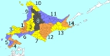
Subprefectures in Hokkaido
Encyclopedia
Hokkaido Prefecture
had 14 branch offices called 支庁 (shichō) in Japanese, which is often translated in English as subprefectures. Normally, a subprefecture consists of a few to a dozen cities, towns, and/or villages.
For historical reasons, some older people in Hokkaido use the subprefecture name suffixed by -kannai in their address.
Today, fourteen shichō effectively cover all of Hokkaido. Technically, the shichō cover only towns and villages, although some commissioned business is conducted for cities.
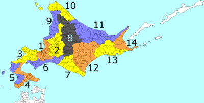
Numbers are those of the map above.
Japan claims the southern part of Kuril Islands
(Northern Territories
), currently administered by Russia, belong to Nemuro Subprefecture. However, the table above excludes these islands' data.
However, it was impossible to make the reform on time. The Public Offices Election Act and the Election Law were not amended on April 1, 2009, but the amendment the Public Offices Election Act was passed in the prefectural assembly on March 31, 2009 and took effect from April 1, 2010.
Hokkaido
, formerly known as Ezo, Yezo, Yeso, or Yesso, is Japan's second largest island; it is also the largest and northernmost of Japan's 47 prefectural-level subdivisions. The Tsugaru Strait separates Hokkaido from Honshu, although the two islands are connected by the underwater railway Seikan Tunnel...
had 14 branch offices called 支庁 (shichō) in Japanese, which is often translated in English as subprefectures. Normally, a subprefecture consists of a few to a dozen cities, towns, and/or villages.
For historical reasons, some older people in Hokkaido use the subprefecture name suffixed by -kannai in their address.
History of shichō in Hokkaido
| 1897 | Nineteen shichō were placed under Hokkaido Agency (an agency of the national government): Sapporo, Hakodate, Kameda, Matsumae, Hiyama, Suttsu, Iwanai, Otaru, Sorachi, Kamikawa, Mashike, Souya, Abashiri, Muroran, Urakawa, Kushiro, Kasai, Nemuro, and Shana. |
| 1899 | Sapporo-ku, Hakodate-ku, and Otaru-ku were established as municipalities independent of shichō. Sapporo-shichō and Otaru-shichō were continued with remaining area, but Hakodate-shichō was dissolved. Previous Kameda-shichō was renamed Hokodate-shichō. |
| 1903 | Matsumae-shichō was merged with Hakodate-shichō. Shana-shichō was merged with Nemuro-shichō. |
| 1910 | Suttsu-shichō, Iwanai-shichō, and Otaru-shichō were merged to form Shiribeshi-shichō. |
| 1914 | Asahikawa-ku was established as a municipality independent of Kamikawa-shichō. Mashike-shichō was renamed as Rumoi-shichō. |
| 1918 | Muroran-ku was established as a municipality independent of Muroran-shichō. |
| 1920 | Kushiro-ku was established as a municipality independent of Kushiro-shichō. |
| 1922 | The six ku were restated as shi (cities). Sapporo-shichō was renamed Ishikari-shichō. Hakodate-shichō was renamed Oshima-shichō. Muroran-shichō was renamed Iburi-shichō. |
| 1932 | Urakawa-shichō was renamed Hidaka-shichō. Kasai-shichō was renamed Tokachi-shichō. |
| 1947 | Hokkaido Agency was abolished and Hokkaidō Prefecture Hokkaido , formerly known as Ezo, Yezo, Yeso, or Yesso, is Japan's second largest island; it is also the largest and northernmost of Japan's 47 prefectural-level subdivisions. The Tsugaru Strait separates Hokkaido from Honshu, although the two islands are connected by the underwater railway Seikan Tunnel... was established. Hokkaidō Prefecture took over shichō. |
Today, fourteen shichō effectively cover all of Hokkaido. Technically, the shichō cover only towns and villages, although some commissioned business is conducted for cities.
List of subprefectures
Numbers are those of the map above.
| No. | Subprefecture Subprefectures of Japan Certain prefectures of Japan are now, or once were, divided into subprefectures. The subprefecture is the jurisdiction surrounding a of the prefectural government. Normally, the area of a subprefecture consists of a few to a dozen cities, towns, and/or villages. Subprefectures are formed to... |
Japanese | Capital | Largest city | Region | Pop. | Area (km²) |
Density Population density Population density is a measurement of population per unit area or unit volume. It is frequently applied to living organisms, and particularly to humans... (/km²) |
Municip. Municipalities of Japan Japan has three levels of government: national, prefectural, and municipal. The nation is divided into 47 prefectures. Each prefecture consists of numerous municipalities. There are four types of municipalities in Japan: cities, towns, villages and special wards... |
Distr. Districts of Japan The was most recently used as an administrative unit in Japan between 1878 and 1921 and is roughly equivalent to the county of the United States, ranking at the level below prefecture and above city, town or village. As of 2008, cities belong directly to prefectures and are independent from... |
|---|---|---|---|---|---|---|---|---|---|---|
| 11 | Okhotsk Okhotsk Subprefecture is a subprefecture of Hokkaido, Japan. It was renamed from the earlier Abashiri Subprefecture on April 1, 2010. Abashiri Subprefecture was established in 1897.-Naming:Abashiri Prefecture was named after the subprefectural office in Abashiri... |
オホーツク | Abashiri Abashiri, Hokkaido is a city located in Okhotsk Subprefecture, Hokkaido, Japan.Abashiri is known as the site of the Abashiri Prison, a Meiji-era facility used for the incarceration of political prisoners... |
 Kitami, Hokkaido is a city located in Okhotsk Subprefecture, Hokkaido, Japan. It is the most populous city and the commercial center in the subprefecture, although the subprefectural capital is Abashiri.Kitami is in central Okhotsk Subprefecture. The Kitami Mountains are nearby.... |
East or North | 324,719 | 10,690.55 | 30.37 | 19 | 4 |
| 7 | Hidaka Hidaka Subprefecture is a subprefecture of Hokkaidō, Japan. The west side of the Hidaka mountains occupies most of the area. Hidaka is sparsely populated and has many of Hokkaidō's natural resources... |
日高 |  Urakawa, Hokkaido is a town located in Urakawa District, Hidaka, Hokkaidō, Japan.As of 2008, the town has an estimated population of 14,814 and a density of 21.3 persons per km². The total area is 694.24 km².-External links:* in Japanese... |
Shinhidaka Shinhidaka, Hokkaido is a town located in Hidaka District, Hidaka Subprefecture, Hokkaidō, Japan. Shinhidaka is the most populous town and the economic center of Hidaka Subprefecture.-History:... |
Central or South | 81,403 | 4,811.96 | 16.92 | 7 | 6 |
| 5 | Hiyama Hiyama Subprefecture is a subprefecture of Hokkaidō, Japan located on the Oshima Peninsula on the Sea of Japan side. It includes Okushiri Island. It was established in 1897.-Towns and villages by district:* Hiyama District** Assabu** Esashi ** Kaminokuni* Kudō District... |
檜山 | Esashi Esashi, Hokkaido (Hiyama) is a town in Hiyama District, Hiyama Subprefecture, Hokkaidō, Japan. It is the capital of the subprefecture.One of the oldest towns in Hokkaidō, the name Esashi comes from the Ainu word for konbu, a type of edible kelp well known in Japan... |
Setana Setana, Hokkaido is a town located in Kudō District, Hiyama, Hokkaidō, Japan.As of December 2008, the town has an estimated population of 10,190 and a density of 15.96 persons per km²... |
South | 46,999 | 2,629.88 | 17.87 | 7 | 5 |
| 6 | Iburi Iburi Subprefecture is a subprefecture of Hokkaidō, Japan.- Geography :Located in south-central Hokkaido, Iburi stretches East-West and North-South. Iburi covers an area of . Iburi borders Oshima subprefecture to the West, Shiribeshi, Ishikari, and Sorachi subprefectures to the North, and Hidaka subprefecture to the... |
胆振 |  Muroran, Hokkaido is a city and port located in Iburi, Hokkaidō, Japan. It is the capital city of Iburi Subprefecture.As of 2008, the city has an estimated population of 96,724 and a density of 1,210 people per km². The total area is 80.65 km².- History :... |
 Tomakomai, Hokkaido is a city and port located in Iburi, Hokkaido, Japan. Though its name implies a small, idyllic town, it is the largest city in the Iburi Subprefecture. As of 2008, it had an estimated population of 173,504 and a population density of 310 persons per km²... |
Central or South | 426,627 | 3,698.00 | 115.37 | 11 | 4 |
| 1 | Ishikari Ishikari Subprefecture is a subprefecture of Hokkaidō prefecture, Japan, located in the western part of the island. Its population in 2003 was 2,279,943.There are 6 cities, three towns, and one village under its jurisdiction. The subprefectural capital is Sapporo, also the capital of Hokkaidō prefecture... |
石狩 | Sapporo Sapporo, Hokkaido is the fourth-largest city in Japan by population, and the largest city on the island of Hokkaido. It is the capital of Hokkaidō Prefecture, located in Ishikari Subprefecture, and an ordinance-designated city of Japan.... |
Sapporo | Central | 2,310,001 | 3,539.86 | 652.57 | 8 | 1 |
| 8 | Kamikawa Kamikawa Subprefecture is a subprefecture of Hokkaidō, Japan. The name is derived from Kamikawa no hitobito no Shūraku , a translation of the Ainu Peni Unguri Kotan. Settlement began in 1867... |
上川 |  Asahikawa, Hokkaido is a city in Kamikawa Subprefecture, Hokkaido, Japan. It is the capital of the subprefecture and the second-largest city in Hokkaido, after Sapporo. It has been a Core city since April 1, 2000... |
|
North or Central | 535,456 | 9,852.17 | 54.35 | 22 | 5 |
| 13 | Kushiro Kushiro Subprefecture is a subprefecture of Hokkaidō, Japan.-Towns and villages by district:* Akan District** Tsurui* Akkeshi District** Akkeshi** Hamanaka* Kawakami District** Shibecha** Teshikaga* Kushiro District** Kushiro* Shiranuka District** Shiranuka- History :... |
釧路 |  Kushiro, Hokkaido is a city located in Kushiro Subprefecture, Hokkaidō, Japan. It is the capital city of Kushiro Subprefecture, as well as the most populous city in eastern Hokkaidō.... |
|
East | 261,883 | 5,997.38 | 43.67 | 8 | 5 |
| 14 | Nemuro Nemuro Subprefecture is a subprefecture of Hokkaidō, Japan. The Japanese claim the disputed Southern Kurile Islands as part of this subprefecture.... |
根室 |  Nemuro, Hokkaido -Transportation:Nearby Nakashibetsu Airport serves Nemuro.-Railways:*Hokkaido Railway Company – Nemuro Main Line**Stations in the city: Nemuro, Higashi-Nemuro, Hanasaki, Nishi-Wada, Kombumori, Ochiishi, Bettoga, Hattaushi, Attoko-Sightseeing:*Cape Nosappu... |
|
East | 84,035 | 3,406.23 | 24.67 | 5 | 3 |
| 4 | Oshima Oshima Subprefecture is a subprefecture of Hokkaidō, Japan. As of 2004 it had a population of 456,621 and an area of 3,715.38 km².Hakodate Airport is located in the City of Hakodate.- Geography :-Towns and villages by district:* Futami District** Yakumo* Kameda District... |
渡島 | Hakodate Hakodate, Hokkaido is a city and port located in Oshima Subprefecture, Hokkaido, Japan. It is the capital city of Oshima Subprefecture.Hakodate was Japan's first city whose port was opened to foreign trade in 1854 as a result of Convention of Kanagawa, and used to be the most important port in northern Japan... |
Hakodate | South | 449,371 | 3,936.32 | 114.16 | 11 | 6 |
| 9 | Rumoi Rumoi Subprefecture is a subprefecture of Hokkaidō, Japan. As of 2004, it had a population of 63,406 and an area of 4,019.97km².-Towns and villages by district:* Mashike District** Mashike* Rumoi District** Obira* Teshio District** Enbetsu** Horonobe** Teshio... |
留萌 | Rumoi Rumoi, Hokkaido is a city located in Rumoi, Hokkaidō, Japan. It is the capital of Rumoi Subprefecture.As of 2008, the city has an estimated population of 26,017 and the density of 87.5 persons per km². The total area is 297.44 km².The city was founded on October 1, 1947.... |
Rumoi | North | 61,488 | 4,019.91 | 15.30 | 9 | 4 |
| 3 | Shiribeshi Shiribeshi Subprefecture is a subprefecture of Hokkaidō, Japan. The subprefecture's capital is Kutchan. As of July 31, 2004, the estimated population was 256,184 and the area was 4,305.65 km².- Towns and villages by district :* Abuta District** Kimobetsu... |
後志 | Kutchan Kutchan, Hokkaidō -Neighboring municipalities:*Shiribeshi**Abuta District: Kyōgoku, Niseko**Isoya District: Rankoshi**Iwanai District: Kyōwa**Yoichi District: Niki, Akaigawa**Kimobetsu and Makkari of the Abuta District lie on the southern side of Mount Yōtei.-History:... |
 Otaru, Hokkaido is a city and port in Shiribeshi, Hokkaido, Japan, northwest of Sapporo. The city faces the Ishikari Bay, and has long served as the main port of the bay. With its many historical buildings, Otaru is a popular tourist destination... |
Central | 250,065 | 4,305.82 | 58.08 | 20 | 9 |
| 2 | Sorachi Sorachi Subprefecture is a subprefecture of Hokkaidō, Japan. As of 2004, its estimated population is 373,736 and its area is 6,558.26 km².-Cities:* Akabira* Ashibetsu* Bibai* Fukagawa* Iwamizawa * Mikasa* Sunagawa* Takikawa* Utashinai* Yūbari... |
空知 |  Iwamizawa, Hokkaido is a city located in Sorachi Subprefecture, Hokkaidō, Japan.On March 27, 2006 the town of Kurisawa, and the village of Kita, both from Sorachi District, Sorachi Subprefecture, have merged into Iwamizawa.... |
|
Central or North | 365,563 | 6,558.22 | 55.74 | 25 | 4 |
| 10 | Sōya Soya Subprefecture is a subprefecture of Hokkaidō, Japan. Its population is estimated to be 77,500 as of July 31, 2004 and its area is 4,050.84 km². It is the northernmost subprefecture of Japan.Wakkanai Airport is located in Wakkanai... |
宗谷 |  Wakkanai, Hokkaido is a city located in Sōya, Hokkaidō. It is the capital of Sōya Subprefecture and the northernmost city in Japan. It contains Japan's northernmost point, Cape Soya, from which the Russian island of Sakhalin can be seen.... |
|
North | 75,665 | 4,050.76 | 18.68 | 9 | 5 |
| 12 | Tokachi Tokachi Subprefecture is a subprefecture of Hokkaidō, Japan corresponding to the old province of Tokachi. As of 2004 its estimated population is 360,802 and its area is 10,830.99 km².Tokachi-Obihiro Airport is in the city of Obihiro.- Geography :-Towns and villages by district:... |
十勝 |  Obihiro, Hokkaido is a city located in Tokachi, Hokkaidō, Japan. Obihiro is the only city in the Tokachi area. The next most populous municipality in Tokachi is the town of Otofuke, with less than a third of Obihiro's population. The city has approximately 500 foreign residents . The city contains the headquarters... |
|
East | 354,147 | 10,831.24 | 32.70 | 19 | 7 |
Japan claims the southern part of Kuril Islands
Kuril Islands
The Kuril Islands , in Russia's Sakhalin Oblast region, form a volcanic archipelago that stretches approximately northeast from Hokkaidō, Japan, to Kamchatka, Russia, separating the Sea of Okhotsk from the North Pacific Ocean. There are 56 islands and many more minor rocks. It consists of Greater...
(Northern Territories
Kuril Islands dispute
The Kuril Islands dispute , also known as the , is a dispute between Japan and Russia over sovereignty over the South Kuril Islands. The disputed islands, which were occupied by Soviet forces during the Manchurian Strategic Offensive Operation at the end of World War II, are under Russian...
), currently administered by Russia, belong to Nemuro Subprefecture. However, the table above excludes these islands' data.
Reorganization
The prefectural government of Hokkaido planned to reorganize the current 14 subprefectures into 9 subprefectural bureaus. Five subprefectures, namely Hidaka, Hiyama, Ishikari, Nemuro, and Rumoi were subject to be cut down. The capital municipalities of these subprefectures opposed the plan, but on June 28, 2008, the prefectural council passed the ordinance of the reorganization. The change should have taken effect in April 2009.However, it was impossible to make the reform on time. The Public Offices Election Act and the Election Law were not amended on April 1, 2009, but the amendment the Public Offices Election Act was passed in the prefectural assembly on March 31, 2009 and took effect from April 1, 2010.
List of subprefectural bureaus
- Sorachi General Subprefectural Bureau (空知総合振興局), Iwamizawa, covering Ishikari and Sorachi areas. (HorokanaiHorokanai, Hokkaidois a town located in Uryū District, Sorachi Subprefecture, Hokkaidō, Japan.As of 2007, the town has an estimated population of 1,838 and a density of 2.67 persons per km². The total area is 767.03 km².-External links:* in Japanese...
belongs to Kamikawa Subprefectural Bureau.)- Ishikari Subprefectural Bureau (石狩振興局), Sapporo, covering Ishikari area
- Shiribeshi General Subprefectural Bureau (後志総合振興局), Kutchan, covering Shiribeshi area
- Iburi General Subprefectural Bureau (胆振総合振興局), Muroran, covering Iburi and Hidaka areas
- Hidaka Subprefectural Bureau (日高振興局), Urakawa, covering Hidaka area
- Oshima General Subprefectural Bureau (渡島総合振興局), Hakodate, covering Oshima and Hiyama areas
- Hiyama Subprefectural Bureau (檜山振興局), Esashi, covering Hiyama area
- Kamikawa General Subprefectural Bureau (上川総合振興局), Asahikawa, covering Kamikawa and Rumoi areas
- Rumoi Subprefectural Bureau (留萌振興局), Rumoi, covering Rumoi area. (HoronobeHoronobe, Hokkaidois a town located in Teshio District, Rumoi, Hokkaidō, Japan. There is a JR train station, Horonobe Station which connects Horonobe-town with other cities in Hokkaido....
belongs to Soya Subprefectural Bureau.)
- Rumoi Subprefectural Bureau (留萌振興局), Rumoi, covering Rumoi area. (Horonobe
- Sōya General Subprefectural Bureau (宗谷総合振興局), Wakkanai, covering Sōya area
- Okhotsk General Subprefectural Bureau (オホーツク総合振興局), Abashiri, covering Abashiri area
- Tokachi General Subprefectural Bureau (十勝総合振興局), Obihiro, covering Tokachi area
- Kushiro General Subprefectural Bureau (釧路総合振興局), Kushiro, covering Kushiro and Nemuro areas
- Nemuro Subprefectural Bureau (根室振興局), Nemuro, covering Nemuro area
External links
- Official websites of the subprefectural bureaus
- The map of the new development bureaus, from Pucchi Guide