

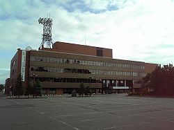
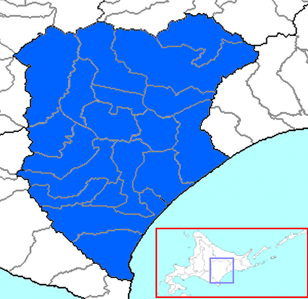
Tokachi Subprefecture
Encyclopedia
is a subprefecture
of Hokkaidō
, Japan
corresponding to the old province of Tokachi
. As of 2004 its estimated population is 360,802 and its area is 10,830.99 km².
Tokachi-Obihiro Airport
is in the city of Obihiro
.
42.929625°N 143.208278°W
Subprefecture
Subprefecture is an administrative division of a country that is below prefecture or province.-Albania:There are twelve Albanian counties or prefectures, each of which is subdivided into several districts, sometimes translated as subprefectures.-Brazil:...
of Hokkaidō
Hokkaido
, formerly known as Ezo, Yezo, Yeso, or Yesso, is Japan's second largest island; it is also the largest and northernmost of Japan's 47 prefectural-level subdivisions. The Tsugaru Strait separates Hokkaido from Honshu, although the two islands are connected by the underwater railway Seikan Tunnel...
, Japan
Japan
Japan is an island nation in East Asia. Located in the Pacific Ocean, it lies to the east of the Sea of Japan, China, North Korea, South Korea and Russia, stretching from the Sea of Okhotsk in the north to the East China Sea and Taiwan in the south...
corresponding to the old province of Tokachi
Tokachi Province
was a short-lived province in Hokkaidō. It corresponded to modern-day Tokachi Subprefecture.-History:After 1869, the northern Japanese island was known as Hokkaido; and regional administrative subdivisions were identified, including Tokachi Province....
. As of 2004 its estimated population is 360,802 and its area is 10,830.99 km².
Tokachi-Obihiro Airport
Tokachi-Obihiro Airport
is an airport located south of Obihiro Station in Obihiro, Hokkaidō, Japan.-Airlines and destinations:-History:The airport opened in March 1981, initially with a runway, taking over the role of the former Obihiro Airport, now Tokachi Airfield. The runway was extended to 2,500 m in November...
is in the city of Obihiro
Obihiro, Hokkaido
is a city located in Tokachi, Hokkaidō, Japan. Obihiro is the only city in the Tokachi area. The next most populous municipality in Tokachi is the town of Otofuke, with less than a third of Obihiro's population. The city has approximately 500 foreign residents . The city contains the headquarters...
.
Geography
Towns and villages by district
- Ashoro DistrictAshoro District, Hokkaidois a district located in Tokachi Subprefecture, Hokkaidō, Japan.As of 2004, the district has an estimated population of 11,424 and a density of 5.66 persons per km²...
- AshoroAshoro, Hokkaidois a town located in Ashoro District, Tokachi, Hokkaidō, Japan.As of 2008, the town has an estimated population of 8,254 and a density of 5.93 persons per km². The total area is 1,408.09 km²....
- RikubetsuRikubetsu, Hokkaidois a town located in Ashoro District, Tokachi, Hokkaidō, Japan.As of 2008, the town has an estimated population of 2,837 and a density of 5.04 persons per km². The total area is 608.81 km².-Climate:Rikubetsu is ranked as Japan's coldest area...
- Ashoro
- Hiroo DistrictHiroo District, Hokkaidois a district located in Tokachi Subprefecture, Hokkaidō, Japan.As of 2004, the district has an estimated population of 16,735 and a density of 10.80 persons per km²...
- HirooHiroo, Hokkaidois a town located in Hiroo District, Tokachi, Hokkaidō, Japan.As of 2008, the town has an estimated population of 8,209 and a density of 14.28 persons per km². The total area is 596.14 km²....
- TaikiTaiki, Hokkaidois a town located in Hiroo District, Tokachi, Hokkaidō, Japan.As of 2008, the town has an estimated population of 6,266 and a density of 7.86 persons per km². The total area is 816.38 km².-External links:* in Japanese...
- Hiroo
- Kamikawa (Tokachi) District
- ShimizuShimizu, Hokkaidois located at the base of the Hidaka Mountain Range in the Kamikawa District, Tokachi, Hokkaidō, Japan. The name Shimizu is taken from the Ainu word Pekerebetsu, which means bright clean river. This town of 10,243, primary source of income is through agriculture. This town, like many others in...
- ShintokuShintoku, Hokkaidois a town located in Kamikawa District, Tokachi, Hokkaidō, Japan.As of 2007, the town has an estimated population of 6,993 and a density of 6.98 persons per km². The total area is 1,063.79 km². Surrounding towns include Sahoro, Shimizu, and Shikaoi....
- Shimizu
- Kasai DistrictKasai District, Hokkaidois a district located in Tokachi Subprefecture, Hokkaidō, Japan.As of 2004, the district has an estimated population of 25,474 and a density of 25.91 persons per km²...
- MemuroMemuro, Hokkaidois a town located in Kasai District, Tokachi, Hokkaidō, Japan.As of 2008, the town has an estimated population of 19,315 and a density of 35.12 persons per km². The total area is 513.91 km²....
- NakasatsunaiNakasatsunai, Hokkaidois a village located in Kasai District, Tokachi, Hokkaidō, Japan.As of 2008, the village has an estimated population of 4,005. The total area is 292.69 km².-External links:...
- SarabetsuSarabetsu, Hokkaidois a village located in Kasai District, Tokachi, Hokkaidō, Japan.As of 2007, the village has an estimated population of 3,393. The total area is 176.45 km².-External links:*...
- Memuro
- Katō DistrictKato District, Hokkaidois a district located in Tokachi Subprefecture, Hokkaidō, Japan.As of 2004, the district has an estimated population of 59,819 and a density of 32.76 persons per km². The total area is 1,825.78 km².-Towns:*Kamishihoro*Otofuke*Shihoro*Shikaoi-History:...
- KamishihoroKamishihoro, Hokkaidois a town located in Katō District, Tokachi Subprefecture, Hokkaidō, Japan.As of 2008, the town has an estimated population of 5,314 and a density of 7.59 personsper km². The total area is 700.87 km².-External links:* in Japanese...
- OtofukeOtofuke, Hokkaidois a town located in Katō District, Tokachi, Hokkaidō, Japan.As of 2008, the town has an estimated population of 44,402 and a density of 89.97 persons per km². The total area is 466.09 km².-External links:...
- ShihoroShihoro, Hokkaidois a town located in Katō District, Tokachi, Hokkaidō, Japan.As of 2008, the town had an estimated population of 6,733 and a density of 26.08 persons per km². The total area is 259.13 km².-External links:* in Japanese...
- ShikaoiShikaoi, Hokkaidois a town located in Katō District, Tokachi, Hokkaidō, Japan. The name "Shikaoi" means "Following deer".As of 2008, the town has an estimated population of 5,723 and a density of 14.52 persons per km²...
- Kamishihoro
- Nakagawa (Tokachi) DistrictNakagawa (Tokachi) District, Hokkaidois a district located in Tokachi Subprefecture, Hokkaidō, Japan. There is a district with the same name in Kamikawa Subprefecture, see Nakagawa District, Hokkaidō....
- HonbetsuHonbetsu, Hokkaidois a town located in Nakagawa District, Tokachi, Hokkaidō, Japan.As of 2008, the town has an estimated population of 8,615 and a density of 23.97 persons per km². The total area is 391.99 km².-External links:* in Japanese....
- IkedaIkeda, HokkaidoIkeda town is a small town in the East of Hokkaido. It is in the region of Tokachi in the sub region of Nakagawa-gun. Tokachi is blessed with almost year-round blue skies, which results in warm summers and cold winters. In the summer temperatures reach 30 degrees Celsius and in winter up to minus...
- MakubetsuMakubetsu, Hokkaidois a town located in Nakagawa District, Tokachi, Hokkaidō, Japan.On February 6, 2006 the village of Chūrui, from Hiroo District, was merged into Makubetsu....
- ToyokoroToyokoro, Hokkaidois a town located in Nakagawa District, Tokachi, Hokkaidō, Japan.As of 2008, the town has an estimated population of 3,749 and a density of 7.17 persons per km². The total area is 536.52 km²....
- Honbetsu
- Tokachi DistrictTokachi District, Hokkaidois a district located in Tokachi Subprefecture, Hokkaidō, Japan.As of 2004, the district has an estimated population of 6,342 and a density of 8.69 persons per km². The total area is 729.64 km².-History:...
- UrahoroUrahoro, Hokkaidois a town located in Tokachi District, Tokachi, Hokkaidō, Japan.As of 2008, the town has an estimated population of 5,993 and a density of 8.69 persons per km². The total area is 729.64 km².-External links:* in Japanese...
- Urahoro
History
- November, 1897 Kasai Subprefecture established
- August, 1932 Kasai Subprefecture renamed Tokachi Subprefecture
- October 20, 1948 Ashoro District transferred from Kushiro SubprefectureKushiro Subprefectureis a subprefecture of Hokkaidō, Japan.-Towns and villages by district:* Akan District** Tsurui* Akkeshi District** Akkeshi** Hamanaka* Kawakami District** Shibecha** Teshikaga* Kushiro District** Kushiro* Shiranuka District** Shiranuka- History :...
External links
Official website42.929625°N 143.208278°W