
Strays of York
Encyclopedia
The Strays of York is a collective name for four areas of open land, comprising in all over 800 acres (3.2 km²), within the City of York
. Their individual names are Bootham Stray, Micklegate Stray (which includes the Knavesmire
and Hob Moor), Monk Stray and Walmgate Stray.
of the City had, since time immemorial
, the right to graze cattle.
After the Parliamentary
Enclosure
s of the eighteenth and early nineteenth centuries, whereby commons were enclosed and rights of pasturage extinguished, areas of grazing land were allotted to the Freemen in lieu of their existing rights. Together with the Knavesmire and Hob Moor, land already used by the City for pasturage, these areas became the Strays, land vested in the Corporation to be held in trust for the Freemen of each of the original four Wards of the City.
chocolate factory and the Bumper Castle pub. Technically, the Stray also includes narrow strips of land bordering on Wigginton Road up to and including Clarence Gardens at the junction with Haxby Road and Clarence Street, but much of this has either been built over or is used as the front gardens of houses. There was a nineteenth-century Herdsman's Cottage on the east side of the road near the level-crossing on the York-Scarborough railway line, but this was demolished in 1968.
and a number of smaller areas to the north-east, including Scarcroft Park. To the west of Tadcaster Road is Hob Moor, although, because of the buildings on this side and the presence beyond them of the London to York railway line
, the greater part of it is invisible from the road.
 Like Monk Stray and the northern end of Bootham Stray, the Knavesmire (53.9385°N 1.0973°W), containing York Racecourse
, is clearly visible and immediately accessible from a main road. A quieter tree-lined public road, Knavesmire Road, runs across the Knavesmire from the cottage orné-style Herdsman's Cottage at the northern end to the South Bank
area of York. South of the racecourse, National Route 65 of the National Cycle Network
, the White Rose cycle route from Middlesbrough
to Hull
, York to Selby
section, crosses the Knavesmire near Knavesmire Wood.
To the north-east, the Knavesmire's boundary is Albermarle Road. But there is a further part of Micklegate Stray between here and the City Walls
. Much of it consists of allotments
, but Scarcroft Park, accessible from the Walls via Scarcroft Lane, is a well-maintained open space with a bowling-green.
crosses the Moor between the Knavesmire and Acomb.
Access from the Knavesmire and Tadcaster Road is via a path that passes some allotments and Hob's Stone, an upright 14th-century coffin-lid with a weathered effigy of a knight, accompanied by a flat stone and a basin. The latter was used as a Plague Stone in the seventeenth century: the basin was filled with vinegar, in which people washed coins in the mistaken belief that bubonic plague
was transmitted via money.
Hob Moor can also be accessed from St Helen's Road/Thanet Road to the south, and from Green Lane and Hob Moor Drive/Holly Bank Road to the north.
More information can be found at http://www.friendsofhobmoor.org.uk.
Green to the Monk's Cross area in the parish of Heworth Without
. The Herdsman's Cottage, a one-storey building of about 1820, is on the west side at the start of Malton Road, and the old Elmfield Villa (1832), which was a Primitive Methodist college, Elmfield College
for 70 years, is about 1000 yards (914.4 m) further up on the right (currently Straylands Grove).
Much of the west side of the Stray is occupied by the Heworth Golf Club. On the eastern side, the Stray in the Heworth area is open parkland. Outside the old City boundary, the areas of Stray on both sides of the road have a more rural air. There are good views of the city, York Minster
.
Road (A19
), either via Kilburn Road and through the allotments, or via the cycle path which runs from the South Bank
area via the Millennium Bridge and the north side of the Imphal Barracks. The entrance from Heslington Road is between the University
's Fairfax House and The Retreat
, and is next to No. 103, the Herdsman's Cottage of about 1840.
From the Herdsman's Cottage, the Stray first slopes upwards - this is the edge of Lamel Hill
- and then gently downwards past the grounds of The Retreat on the left, and there are views over the allotments to the trees of York Cemetery
on the right. At the end of The Retreat's north/south wall, the cycle path crosses the Stray from Fulford Road (on the right) to the Biology building of the University (on the left). At the east (University) end of The Retreat's southern wall is a plaque to Joseph Rowntree
, who is buried in the Quaker
cemetery within The Retreat's grounds. Nearby is an unusual commemorative metal seat.
Further south, towards Heslington Lane, grazing cattle may be seen. The ground is flat and can be waterlogged in wet weather.
York
York is a walled city, situated at the confluence of the Rivers Ouse and Foss in North Yorkshire, England. The city has a rich heritage and has provided the backdrop to major political events throughout much of its two millennia of existence...
. Their individual names are Bootham Stray, Micklegate Stray (which includes the Knavesmire
Knavesmire
The Knavesmire is one of a number of large, marshy undeveloped areas within the city of York in North Yorkshire, England which are collectively known as Strays...
and Hob Moor), Monk Stray and Walmgate Stray.
History
The Strays are the remains of much greater areas of common land on which the hereditary FreemenFreedom of the City
Freedom of the City is an honour bestowed by some municipalities in Australia, Canada, Ireland, France, Italy, New Zealand, South Africa, Spain, the United Kingdom, Gibraltar and Rhodesia to esteemed members of its community and to organisations to be honoured, often for service to the community;...
of the City had, since time immemorial
Time immemorial
Time immemorial is a phrase meaning time extending beyond the reach of memory, record, or tradition, indefinitely ancient, "ancient beyond memory or record"...
, the right to graze cattle.
After the Parliamentary
Act of Parliament
An Act of Parliament is a statute enacted as primary legislation by a national or sub-national parliament. In the Republic of Ireland the term Act of the Oireachtas is used, and in the United States the term Act of Congress is used.In Commonwealth countries, the term is used both in a narrow...
Enclosure
Enclosure
Enclosure or inclosure is the process which ends traditional rights such as mowing meadows for hay, or grazing livestock on common land. Once enclosed, these uses of the land become restricted to the owner, and it ceases to be common land. In England and Wales the term is also used for the...
s of the eighteenth and early nineteenth centuries, whereby commons were enclosed and rights of pasturage extinguished, areas of grazing land were allotted to the Freemen in lieu of their existing rights. Together with the Knavesmire and Hob Moor, land already used by the City for pasturage, these areas became the Strays, land vested in the Corporation to be held in trust for the Freemen of each of the original four Wards of the City.
Ownership and administration
Originally, each Stray was controlled and managed by Pasture Masters for the exclusive benefit of the Freemen resident in their Ward. In 1905, the City took over Micklegate Stray, and in 1907 an Act of Parliament extinguished the Freemen's rights over it in exchange for the payment of an annual sum of money. In 1947, the City approached the Pasture Masters of the other three Strays with a view to making similar arrangements in their cases. Agreements were signed with the Freemen of Bootham Ward in that year, with the Freemen of Walmgate Ward in 1948 and with the Freemen of Monk Ward in 1958. In each case, the Freemen agreed that, in exchange for a small annual payment to them, the City should in future administer their Stray "as an open space for the benefit and enjoyment of the citizens of York for all time". Currently, the Pasture Masters are elected annually by the Freemen of their Wards, and are consulted by the City about major changes of usage. Their permission has to be obtained if the City wishes to erect any building on their Stray other than those intended for the recreation or convenience of the public (sports pavilions, public lavatories, etc.). In 1995, payments were still being made to Freemen of Micklegate Ward and their widows, but payments to Freemen of the other Wards had ceased.Bootham Stray
Bootham Stray (53.9843°N 1.0867°W) is located to the north of York city centre. Most of it lies on either side of Wigginton Road (B1363) between the NestléNestlé
Nestlé S.A. is the world's largest food and nutrition company. Founded and headquartered in Vevey, Switzerland, Nestlé originated in a 1905 merger of the Anglo-Swiss Milk Company, established in 1867 by brothers George Page and Charles Page, and Farine Lactée Henri Nestlé, founded in 1866 by Henri...
chocolate factory and the Bumper Castle pub. Technically, the Stray also includes narrow strips of land bordering on Wigginton Road up to and including Clarence Gardens at the junction with Haxby Road and Clarence Street, but much of this has either been built over or is used as the front gardens of houses. There was a nineteenth-century Herdsman's Cottage on the east side of the road near the level-crossing on the York-Scarborough railway line, but this was demolished in 1968.
Micklegate Stray
Micklegate Stray (53.9446°N 1.0982°W) is to the south-west of the city centre and lies on either side of Tadcaster Road (A1036). The larger eastern section consists of the KnavesmireKnavesmire
The Knavesmire is one of a number of large, marshy undeveloped areas within the city of York in North Yorkshire, England which are collectively known as Strays...
and a number of smaller areas to the north-east, including Scarcroft Park. To the west of Tadcaster Road is Hob Moor, although, because of the buildings on this side and the presence beyond them of the London to York railway line
East Coast Main Line
The East Coast Main Line is a long electrified high-speed railway link between London, Peterborough, Doncaster, Wakefield, Leeds, York, Darlington, Newcastle and Edinburgh...
, the greater part of it is invisible from the road.
Knavesmire and Scarcroft area
York Racecourse
York Racecourse is a horse racing track in the southwest of the city of York in North Yorkshire, England with a spectator capacity of 60,000. The most famous race to be held at York on an annual basis is the Ebor Handicap, which is run during the Ebor Festival meeting in August...
, is clearly visible and immediately accessible from a main road. A quieter tree-lined public road, Knavesmire Road, runs across the Knavesmire from the cottage orné-style Herdsman's Cottage at the northern end to the South Bank
South Bank, York
South Bank is an area to the south of the River Ouse in York. The area is dominated by the disused Terry's chocolate factory and the numerous streets of terraced housing that surround it. Terry's Chocolate Factory opened in 1926, where over the years it manufactured Terry's Chocolate Orange,...
area of York. South of the racecourse, National Route 65 of the National Cycle Network
National Cycle Network
The National Cycle Network is a network of cycle routes in the United Kingdom.The National Cycle Network was created by the charity Sustrans , and aided by a £42.5 million National Lottery grant. In 2005 it was used for over 230 million trips.Many routes hope to minimise contact with motor...
, the White Rose cycle route from Middlesbrough
Middlesbrough
Middlesbrough is a large town situated on the south bank of the River Tees in north east England, that sits within the ceremonial county of North Yorkshire...
to Hull
Kingston upon Hull
Kingston upon Hull , usually referred to as Hull, is a city and unitary authority area in the ceremonial county of the East Riding of Yorkshire, England. It stands on the River Hull at its junction with the Humber estuary, 25 miles inland from the North Sea. Hull has a resident population of...
, York to Selby
Selby
Selby is a town and civil parish in North Yorkshire, England. Situated south of the city of York, along the course of the River Ouse, Selby is the largest and, with a population of 13,012, most populous settlement of the wider Selby local government district.Historically a part of the West Riding...
section, crosses the Knavesmire near Knavesmire Wood.
To the north-east, the Knavesmire's boundary is Albermarle Road. But there is a further part of Micklegate Stray between here and the City Walls
York city walls
The English city of York has, since Roman times, been defended by walls of one form or another. To this day, substantial portions of the walls remain, and York has more miles of intact wall than any other city in England...
. Much of it consists of allotments
Allotment (gardening)
An allotment garden, often called simply an allotment, is a plot of land made available for individual, non-professional gardening. Such plots are formed by subdividing a piece of land into a few or up to several hundreds of land parcels that are assigned to individuals or families...
, but Scarcroft Park, accessible from the Walls via Scarcroft Lane, is a well-maintained open space with a bowling-green.
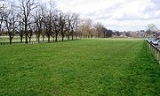
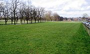
Hob Moor
Hob Moor (53.9466°N 1.1131°W), off the tourist track, is an open space populated by cows, walkers and cyclists; it sometimes becomes waterlogged in wet weather. The main part of the Moor, to the west of the railway, is shaped rather like an inverted sweater, a body with two dangling arms. Two schools are located on the Moor, as is the Edmund Wilson Swimming Pool, whose future is currently in doubt. A signposted cycle pathSegregated cycle facilities
Segregated cycle facilities are marked lanes, tracks, shoulders and paths designated for use by cyclists from which motorised traffic is generally excluded...
crosses the Moor between the Knavesmire and Acomb.
Access from the Knavesmire and Tadcaster Road is via a path that passes some allotments and Hob's Stone, an upright 14th-century coffin-lid with a weathered effigy of a knight, accompanied by a flat stone and a basin. The latter was used as a Plague Stone in the seventeenth century: the basin was filled with vinegar, in which people washed coins in the mistaken belief that bubonic plague
Bubonic plague
Plague is a deadly infectious disease that is caused by the enterobacteria Yersinia pestis, named after the French-Swiss bacteriologist Alexandre Yersin. Primarily carried by rodents and spread to humans via fleas, the disease is notorious throughout history, due to the unrivaled scale of death...
was transmitted via money.
Hob Moor can also be accessed from St Helen's Road/Thanet Road to the south, and from Green Lane and Hob Moor Drive/Holly Bank Road to the north.
More information can be found at http://www.friendsofhobmoor.org.uk.
Monk Stray
Monk Stray (53.9812°N 1.0413°W), to the north-east of York on either side of Malton Road (A1036). It extends as a thin strip of land for about one and a half miles from HeworthHeworth, York
Heworth is part of the city of York in North Yorkshire, England, about north-east of the centre. It is sometimes referred to as Heworth Village...
Green to the Monk's Cross area in the parish of Heworth Without
Heworth Without
Heworth Without is a civil parish in the City of York, North Yorkshire, England consisting of those parts of Heworth that lay beyond the city boundary....
. The Herdsman's Cottage, a one-storey building of about 1820, is on the west side at the start of Malton Road, and the old Elmfield Villa (1832), which was a Primitive Methodist college, Elmfield College
Elmfield College
Elmfield College, York , originally called "Connexional College" or "Jubilee College" in honour of the Primitive Methodist Silver Jubilee in 1860, was a Primitive Methodist college on the outskirts of Heworth, York, England, near Monk Stray.-Primitive Methodism in York:The college was a national...
for 70 years, is about 1000 yards (914.4 m) further up on the right (currently Straylands Grove).
Much of the west side of the Stray is occupied by the Heworth Golf Club. On the eastern side, the Stray in the Heworth area is open parkland. Outside the old City boundary, the areas of Stray on both sides of the road have a more rural air. There are good views of the city, York Minster
York Minster
York Minster is a Gothic cathedral in York, England and is one of the largest of its kind in Northern Europe alongside Cologne Cathedral. The minster is the seat of the Archbishop of York, the second-highest office of the Church of England, and is the cathedral for the Diocese of York; it is run by...
.
Walmgate Stray
Walmgate Stray (53.9467°N 1.0622°W), also known as Low Moor, is the least visible of the Strays as, unlike the others, it is not on or adjacent to a classified road. It lies to the south-east of the city, with a short boundary on Heslington Lane and direct access from Heslington Road and University Road, as well as from FulfordFulford
Fulford is a historic village and civil parish on the outskirts of York, England. Situated to the south of the city, on the east bank of the River Ouse, it was the site of the 11th century Battle of Fulford...
Road (A19
A19 road
The A19 is a major road in England running approximately parallel to and east of the A1 road, although the two roads meet at the northern end of the A19, the two roads originally met at the southern end of the A19 in Doncaster but the old route of the A1 was changed to the A638. From Sunderland...
), either via Kilburn Road and through the allotments, or via the cycle path which runs from the South Bank
South Bank, York
South Bank is an area to the south of the River Ouse in York. The area is dominated by the disused Terry's chocolate factory and the numerous streets of terraced housing that surround it. Terry's Chocolate Factory opened in 1926, where over the years it manufactured Terry's Chocolate Orange,...
area via the Millennium Bridge and the north side of the Imphal Barracks. The entrance from Heslington Road is between the University
University of York
The University of York , is an academic institution located in the city of York, England. Established in 1963, the campus university has expanded to more than thirty departments and centres, covering a wide range of subjects...
's Fairfax House and The Retreat
The Retreat
The Retreat, commonly known as the York Retreat, is a place in England for the treatment of people with mental health needs. Located in Lamel Hill in York, it operates as a not for profit charitable organisation....
, and is next to No. 103, the Herdsman's Cottage of about 1840.
From the Herdsman's Cottage, the Stray first slopes upwards - this is the edge of Lamel Hill
Lamel Hill
Lamel Hill, once known as Heslington Hill, is located to the south-east of the centre of York. It is the location of The Retreat and of the northern part of Walmgate Stray. It is best-known for having been the location of a Parliamentary gun-emplacement aimed at Walmgate Bar in the City Walls...
- and then gently downwards past the grounds of The Retreat on the left, and there are views over the allotments to the trees of York Cemetery
York Cemetery, York
York Cemetery is a cemetery located in the city of York, England. Founded in 1837, it now encompasses 24 acres and is owned and administered by The York Cemetery Trust with support of the Friends of York Cemetery. It is situated on Cemetery Road in the Fishergate area of York. It has approximately...
on the right. At the end of The Retreat's north/south wall, the cycle path crosses the Stray from Fulford Road (on the right) to the Biology building of the University (on the left). At the east (University) end of The Retreat's southern wall is a plaque to Joseph Rowntree
Joseph Rowntree
Joseph Rowntree may be:*Joseph Rowntree , English grocer and educational reformer*Joseph Rowntree , son of the above, English chocolate manufacturer and philanthropist...
, who is buried in the Quaker
Religious Society of Friends
The Religious Society of Friends, or Friends Church, is a Christian movement which stresses the doctrine of the priesthood of all believers. Members are known as Friends, or popularly as Quakers. It is made of independent organisations, which have split from one another due to doctrinal differences...
cemetery within The Retreat's grounds. Nearby is an unusual commemorative metal seat.
Further south, towards Heslington Lane, grazing cattle may be seen. The ground is flat and can be waterlogged in wet weather.
External links
- York Freemen through the Ages
- Common lands and strays, A History of the County of Yorkshire: the City of York (1961), pp. 498-506. British History Online, accessed 24 May 2007.