
Stratton, Dorset
Encyclopedia
Stratton is a civil parish in West Dorset
, England
, in the Frome valley
about 3 miles (4.8 km) north-west of Dorchester. The parish
includes the village
itself and the hamlet
s of Grimstone
, Ash Hill and Wrackleford, all of which lie on or near main road, the A37
. Ash Hill is a small estate east of the village near the railway. Wrackleford is a group of houses further east and centred about Wrackleford House and including Higher Wrackleford and Lower Wrackleford. In addition there are a number of isolated farms and houses including a few in an area called Langford near the Sydling Water
in the north-west part of the parish.
The name Stratton means 'Farm on the Street'. The Street referred to the Roman road
from Durnovaria
(Dorchester) to Lindinis
(Ilchester
) which passes through the village.
The parish has an area of about 1710 acres (692 ha). Most of this is agricultural land lying north of the village where the land rises from about 250 feet (76.2 m) to about 620 feet (189 m). Stratton parish is bounded by the parishes of Bradford Peverell
, Frampton
, Sydling St. Nicholas
, Godmanstone
and Charminster
.
District Council
and the Three Valleys ward of Dorset County Council
.
and at the northern edge of this and close to the village is a winterbourne
called the Wrackle which aids the flow of the main river. One well used footpath crosses the flood plain between the village and Bradford Peverell while another less well used one crosses between Grimstone and Muckleford.
The western boundary of the parish between it and Frampton is generally marked by Sydling Water.
.jpg) The principal monument in the parish is the Celtic settlement on Grimstone Down. This consists of traces of Celtic fields
The principal monument in the parish is the Celtic settlement on Grimstone Down. This consists of traces of Celtic fields
covering more than.100 acres (40.5 ha) near the centre of this area, between the field-banks, several hollowed tracks converge on a series of smaller enclosures which indicate the position of the main settlement. See an air photo of the settlement and another here
As well as the Celtic settlement there is a number of Bronze Age
barrow
.
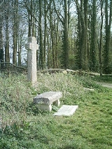
Near here is the base of a mediaeval cross called Jackman's Cross. A new stone cross and bench nearby were erected to mark the Millennium.
The village lies on or near the Roman road linking Durnovaria (Dorchester) with Lindinis (Ilchester). This road passed through Bradford Peverell and crossed the River Frome and its flood plain, passed the current village and then followed a line approximately along the track to Grimstone Dairy, then near Grimstone Viaduct
and then along the line of the A37 towards Yeovil
on the section known as Long Ash Lane.
By mediaeval times it seems that although the same line was used for the main road west of the village, to the east an alternative route was used. This followed the current line of the A37 to Wrackleford, then through Charminster, up East Hill and then into Dorchester through Burton.
A Turnpike trust
, the Maiden Newton Trust, was established in 1777-8 and included the main road through the parish. It seems that originally the same line was used for this turnpike. A route from Frampton to the main road near Winterbourne Steepleton
was included in this trust but did not pass through the Stratton parish, being on a more direct route near Muckleford. In 1797-8 a continuing act was passed for this trust. This 1797-8 act changed part of the line of the main road and part of the route from Frampton to the main road at Winterbourne Steepleton to what are now the existing roads. The part of the future A37 between Stratton village and Grimstone kept to a more level route south of the previous route and linked up to a new road near Muckleford on the route towards Winterbourne Steepleton at a point called Brewers Ash. The toll house at this corner still exists. The original route from Muckleford directly to Frampton
fell into disuse. There had been a toll gate in Grimstone before this date but this must have been at a different location.
Although not in Stratton parish, it may be noted that it was not until the third continuing act of 1840 that the new road between Wrackleford and Dorchester was authorized. This left the previous route just west of Charminster and crossed the meadows to join the previous road at the Bottom of the Grove in Dorchester, the now familiar road into Dorchester.
The last major change to the route of the main road within the parish was the Stratton bypass. This was built in 1967 between the village and the railway line and necessitated the demolition of the village school which stood at the west end of the village near the railway line.
-Weymouth Heart of Wessex Line
passes through the parish. This was originally part of the Wiltshire, Somerset & Weymouth Railway which opened on 20th January 1857 and later became part of the Great Western Railway
.
The broad gauge
Wiltshire, Somerset & Weymouth Railway was incorporated in 1845. However in 1848 work on the line stopped completely. In 1850 the Great Western Railway assumed responsibility for the line but it was not until 1857 that the line opened. The line was converted to standard gauge
in 1874, a change that took just five days.
The first reference to the railway in the Parish register
s is on 29th August 1847 when two children were baptised whose fathers were recorded as "Miner on the Wilts & Somerset Railroad". The Parish registers also record the burials of two men connected with the railway who died before its opening. On 6th November 1854 Alfred Needs was buried. He was 16 years old and was "killed by a truck on the rail road". On 25th January 1855 George Moss, aged 46, "Railway Labourer", was buried.
From the north-west the railway enters the parish soon after leaving the Frampton Tunnel. The railway then passes over Grimstone Viaduct, under which passes Sydling Water and the road from Sydling St. Nicholas. The railway then passes Grimstone and Frampton railway station
before entering a cutting. It then passes north of Stratton village, past Bradford Peverell & Stratton Halt
, over the A37 and then over the River Frome as it leaves the parish towards Dorchester. Three footpaths near the village cross the railway line.
Grimstone and Frampton railway station is in the hamlet of Grimstone at the western edge of the parish and was part of the original railway. Bradford Peverell & Stratton Halt was opened in 1933. British Rail
ways closed both stations in 1966.
of Saint Mary
is at the centre of the village. The walls are of local rubble stone
with dressings of the same material. The roofs are tiled, lead and stone slates.
The West Tower is 14th or 15th century and has a ring
of five bells. The church bells have recently been renovated and many photos can be seen on the village web site. The tower has a 16th century five-sided enclosed oak staircase. It is supported by a moulded post and is believed to be of unique design.
The remainder of the parish church was largely rebuilt in 1891.
The Nave
has a number of 15th century windows with traces of mediaeval glass. The early south doorway is now blocked. The north porch is modern.
For a long period up to the rebuilding the Church had no Chancel
, the chancel arch having been bricked up. In 1891 a new chancel and chancel arch were built, and the original chancel arch was incorporated into the west wall of the new chancel.
The Parish registers date from Christmas Day 1561, the first entry recording the burial of a John Lymington on that day.
St Mary's parish is part of the United Benefice of Bradford Peverell, Stratton, Frampton and Sydling St. Nicholas, known unofficially as the "Chalk Stream Churches".
The Friends of St Mary's Church is a voluntary body that holds regular fundraising events to help defray the costs of maintaining the fabric of the church and churchyard.
A Methodist
chapel was built in the village in 1912 and closed in 1971. It was sold in 1975 and is now a private home.
is just outside the churchyard
. It records the names of ten men who died in the Great War
and three who died in The Second World War
. It was dedicated on 30th November 1919.
The four officers mentioned on the Great War section are Alexander, Percy and Charles Pope, sons of Alfred and Elizabeth Mary Pope of Wrackleford and Alan Roderick Haig-Brown who was their brother-in-law, having married Violet Mary Pope, a daughter of Alfred and Elizabeth Mary. A plaque in the church gives more details of these four men.
Lists of men of the parish who served in the Great War and The Second World War are in the church.
, The Saxon Arms, a new Village Hall
, a village green
with a play area and a sports field.
of the parish since the first UK census
of 1801.
In 1989 a local landowner sold some land to developers. The major residential development on this land accounts for most of the increase in population between the 1991 and 2001 censuses. This development is now complete and in 2009 the population was estimated to be about 610.
West Dorset
West Dorset is a local government district and parliamentary constituency in Dorset, England. Its council is based in Dorchester. The district was formed on 1 April 1974, under the Local Government Act 1972, and was a merger of the boroughs of Bridport, Dorchester and Lyme Regis, along with...
, England
England
England is a country that is part of the United Kingdom. It shares land borders with Scotland to the north and Wales to the west; the Irish Sea is to the north west, the Celtic Sea to the south west, with the North Sea to the east and the English Channel to the south separating it from continental...
, in the Frome valley
River Frome, Dorset
The River Frome is a river in Dorset in the south of England. At 30 miles long it is the major chalkstream in southwest England. It is navigable upstream from Poole Harbour as far as the town of Wareham.-Geography:...
about 3 miles (4.8 km) north-west of Dorchester. The parish
Parish
A parish is a territorial unit historically under the pastoral care and clerical jurisdiction of one parish priest, who might be assisted in his pastoral duties by a curate or curates - also priests but not the parish priest - from a more or less central parish church with its associated organization...
includes the village
Village
A village is a clustered human settlement or community, larger than a hamlet with the population ranging from a few hundred to a few thousand , Though often located in rural areas, the term urban village is also applied to certain urban neighbourhoods, such as the West Village in Manhattan, New...
itself and the hamlet
Hamlet (place)
A hamlet is usually a rural settlement which is too small to be considered a village, though sometimes the word is used for a different sort of community. Historically, when a hamlet became large enough to justify building a church, it was then classified as a village...
s of Grimstone
Grimstone
Grimstone is a hamlet at the confluence of Sydling Water and the River Frome in the western part of the civil parish of Stratton, Dorset.The Great Western Railway opened Grimstone and Frampton railway station and Grimstone Viaduct in 1857 and British Railways closed the station in 1966.Grimstone's...
, Ash Hill and Wrackleford, all of which lie on or near main road, the A37
A37 road
The A37 is a major road in southern England. It runs north from the A35 at Dorchester in Dorset into Somerset through Yeovil and Shepton Mallet before terminating at the Three Lamps junction with the A4 in central Bristol...
. Ash Hill is a small estate east of the village near the railway. Wrackleford is a group of houses further east and centred about Wrackleford House and including Higher Wrackleford and Lower Wrackleford. In addition there are a number of isolated farms and houses including a few in an area called Langford near the Sydling Water
Sydling Water
The Sydling Water is an eight km long river in Dorset, England, which flows from north to south from Up Sydling until it joins the River Frome near Grimstone....
in the north-west part of the parish.
The name Stratton means 'Farm on the Street'. The Street referred to the Roman road
Roman road
The Roman roads were a vital part of the development of the Roman state, from about 500 BC through the expansion during the Roman Republic and the Roman Empire. Roman roads enabled the Romans to move armies and trade goods and to communicate. The Roman road system spanned more than 400,000 km...
from Durnovaria
Durnovaria
Durnovaria is the Latin form of the Brythonic name for the Roman town of Dorchester in the modern English county of Dorset.-Romans at Maiden Castle:...
(Dorchester) to Lindinis
Lindinis
Lindinis was a small town in the Roman province of Britannia. Today it is known as Ilchester, located in the English county of Somerset....
(Ilchester
Ilchester
Ilchester is a village and civil parish, situated on the River Yeo or Ivel, five miles north of Yeovil, in the English county of Somerset. The parish, which includes the village of Sock Dennis and the old parish of Northover, has a population of 2,021...
) which passes through the village.
The parish has an area of about 1710 acres (692 ha). Most of this is agricultural land lying north of the village where the land rises from about 250 feet (76.2 m) to about 620 feet (189 m). Stratton parish is bounded by the parishes of Bradford Peverell
Bradford Peverell
Bradford Peverell is a village in west Dorset, England, situated in the Frome valley two miles north west of Dorchester on the A37 road. The village has a population of 344 .- External links :*...
, Frampton
Frampton, Dorset
Frampton is a village in west Dorset, England, situated in the Frome valley three miles north west of Dorchester at . The village has a population of 456 , 6.9% of dwellings are second homes ....
, Sydling St. Nicholas
Sydling St Nicholas
Sydling St Nicholas is a village in the county of Dorset in southwest England. It is situated in the West Dorset district of the county, about nine miles northwest of the county town of Dorchester. It is sited on Sydling Water, a tributary of the River Frome. Sydling Water divides upon entering the...
, Godmanstone
Godmanstone
Godmanstone is a village in west Dorset, England, situated in the Cerne Valley four miles north of Dorchester and south of Cerne Abbas. The village has a population of 144 in about 60 homes....
and Charminster
Charminster
Charminster is a village in west Dorset, England, situated on the River Cerne and A352 road one mile north of Dorchester. The village has a population of 1,940 . The village has a small church of St. Mary. These two things give the village its name, Cerneminster , which eventually evolved into...
.
Administrative areas
Stratton has its own Parish Council, it is in the Frome Valley ward of West DorsetWest Dorset
West Dorset is a local government district and parliamentary constituency in Dorset, England. Its council is based in Dorchester. The district was formed on 1 April 1974, under the Local Government Act 1972, and was a merger of the boroughs of Bridport, Dorchester and Lyme Regis, along with...
District Council
Non-metropolitan district
Non-metropolitan districts, or colloquially shire districts, are a type of local government district in England. As created, they are sub-divisions of non-metropolitan counties in a so-called "two-tier" arrangement...
and the Three Valleys ward of Dorset County Council
County council
A county council is the elected administrative body governing an area known as a county. This term has slightly different meanings in different countries.-United Kingdom:...
.
Rivers
The southern boundary of the parish between it and Bradford Peverell is generally marked by the River Frome. An area mainly north of the river is a flood plainFloodplain
A floodplain, or flood plain, is a flat or nearly flat land adjacent a stream or river that stretches from the banks of its channel to the base of the enclosing valley walls and experiences flooding during periods of high discharge...
and at the northern edge of this and close to the village is a winterbourne
Winterbourne (stream)
A winterbourne is a stream or river that is dry through the summer months. A winterbourne is sometimes simply called a bourne, from the Anglo-Saxon for a stream flowing from a spring, although this term can also be used for all-year water courses....
called the Wrackle which aids the flow of the main river. One well used footpath crosses the flood plain between the village and Bradford Peverell while another less well used one crosses between Grimstone and Muckleford.
The western boundary of the parish between it and Frampton is generally marked by Sydling Water.
Early monuments
Celtic fields
Celtic field is a popular name for the traces of early agricultural field systems found in North-West Europe, e.g. Belgium, Britain, Germany, Ireland and the Netherlands. The name was given by O.G.S. Crawford. They are sometimes preserved in areas where industrial farming has not been adopted and...
covering more than.100 acres (40.5 ha) near the centre of this area, between the field-banks, several hollowed tracks converge on a series of smaller enclosures which indicate the position of the main settlement. See an air photo of the settlement and another here
As well as the Celtic settlement there is a number of Bronze Age
Bronze Age Britain
Bronze Age Britain refers to the period of British history that spanned from c. 2,500 until c. 800 BC. Lasting for approximately 1700 years, it was preceded by the era of Neolithic Britain and was in turn followed by the era of Iron Age Britain...
barrow
Tumulus
A tumulus is a mound of earth and stones raised over a grave or graves. Tumuli are also known as barrows, burial mounds, Hügelgrab or kurgans, and can be found throughout much of the world. A tumulus composed largely or entirely of stones is usually referred to as a cairn...
.
Near here is the base of a mediaeval cross called Jackman's Cross. A new stone cross and bench nearby were erected to mark the Millennium.
Roads
Refer to Ronald Good's book for more details.The village lies on or near the Roman road linking Durnovaria (Dorchester) with Lindinis (Ilchester). This road passed through Bradford Peverell and crossed the River Frome and its flood plain, passed the current village and then followed a line approximately along the track to Grimstone Dairy, then near Grimstone Viaduct
Grimstone Viaduct
The Grimstone Viaduct is a railway bridge on the Castle Cary-Weymouth "Heart of Wessex" line. It passes over the road from Grimstone to Sydling St. Nicholas and Sydling Water flows underneath it. It is in the hamlet of Grimstone at the western edge of the parish of Stratton.The viaduct is directly...
and then along the line of the A37 towards Yeovil
Yeovil
Yeovil is a town and civil parish in south Somerset, England. The parish had a population of 27,949 at the 2001 census, although the wider urban area had a population of 42,140...
on the section known as Long Ash Lane.
By mediaeval times it seems that although the same line was used for the main road west of the village, to the east an alternative route was used. This followed the current line of the A37 to Wrackleford, then through Charminster, up East Hill and then into Dorchester through Burton.
A Turnpike trust
Turnpike trust
Turnpike trusts in the United Kingdom were bodies set up by individual Acts of Parliament, with powers to collect road tolls for maintaining the principal highways in Britain from the 17th but especially during the 18th and 19th centuries...
, the Maiden Newton Trust, was established in 1777-8 and included the main road through the parish. It seems that originally the same line was used for this turnpike. A route from Frampton to the main road near Winterbourne Steepleton
Winterbourne Steepleton
Winterbourne Steepleton is a village in south west Dorset, England, situated in a winterbourne valley five miles west of Dorchester, next to the village of Winterbourne Abbas. The village has a population of 295 , and derives its name from having one of only three stone church steeples in the...
was included in this trust but did not pass through the Stratton parish, being on a more direct route near Muckleford. In 1797-8 a continuing act was passed for this trust. This 1797-8 act changed part of the line of the main road and part of the route from Frampton to the main road at Winterbourne Steepleton to what are now the existing roads. The part of the future A37 between Stratton village and Grimstone kept to a more level route south of the previous route and linked up to a new road near Muckleford on the route towards Winterbourne Steepleton at a point called Brewers Ash. The toll house at this corner still exists. The original route from Muckleford directly to Frampton
Frampton, Dorset
Frampton is a village in west Dorset, England, situated in the Frome valley three miles north west of Dorchester at . The village has a population of 456 , 6.9% of dwellings are second homes ....
fell into disuse. There had been a toll gate in Grimstone before this date but this must have been at a different location.
Although not in Stratton parish, it may be noted that it was not until the third continuing act of 1840 that the new road between Wrackleford and Dorchester was authorized. This left the previous route just west of Charminster and crossed the meadows to join the previous road at the Bottom of the Grove in Dorchester, the now familiar road into Dorchester.
The last major change to the route of the main road within the parish was the Stratton bypass. This was built in 1967 between the village and the railway line and necessitated the demolition of the village school which stood at the west end of the village near the railway line.
The railway
The Castle CaryCastle Cary
Castle Cary is a market town and civil parish in south Somerset, England, north west of Wincanton and south of Shepton Mallet.The town is situated on the River Cary, a tributary of the Parrett.-History:...
-Weymouth Heart of Wessex Line
Heart of Wessex Line
The Heart of Wessex Line, also known as the Bristol to Weymouth line, is a United Kingdom railway line that runs from Bristol to Westbury to Weymouth...
passes through the parish. This was originally part of the Wiltshire, Somerset & Weymouth Railway which opened on 20th January 1857 and later became part of the Great Western Railway
Great Western Railway
The Great Western Railway was a British railway company that linked London with the south-west and west of England and most of Wales. It was founded in 1833, received its enabling Act of Parliament in 1835 and ran its first trains in 1838...
.
The broad gauge
Broad gauge
Broad-gauge railways use a track gauge greater than the standard gauge of .- List :For list see: List of broad gauges, by gauge and country- History :...
Wiltshire, Somerset & Weymouth Railway was incorporated in 1845. However in 1848 work on the line stopped completely. In 1850 the Great Western Railway assumed responsibility for the line but it was not until 1857 that the line opened. The line was converted to standard gauge
Standard gauge
The standard gauge is a widely-used track gauge . Approximately 60% of the world's existing railway lines are built to this gauge...
in 1874, a change that took just five days.
The first reference to the railway in the Parish register
Parish register
A parish register is a handwritten volume, normally kept in a parish church or deposited within a county record office or alternative archive repository, in which details of baptisms, marriages and burials are recorded.-History:...
s is on 29th August 1847 when two children were baptised whose fathers were recorded as "Miner on the Wilts & Somerset Railroad". The Parish registers also record the burials of two men connected with the railway who died before its opening. On 6th November 1854 Alfred Needs was buried. He was 16 years old and was "killed by a truck on the rail road". On 25th January 1855 George Moss, aged 46, "Railway Labourer", was buried.
From the north-west the railway enters the parish soon after leaving the Frampton Tunnel. The railway then passes over Grimstone Viaduct, under which passes Sydling Water and the road from Sydling St. Nicholas. The railway then passes Grimstone and Frampton railway station
Grimstone and Frampton railway station
Grimstone and Frampton railway station was a station on the Wiltshire, Somerset & Weymouth Railway, part of the Great Western Railway between Maiden Newton and Dorchester. It was in the hamlet of Grimstone which was in the parish of Stratton but also relatively close to the parish of Frampton which...
before entering a cutting. It then passes north of Stratton village, past Bradford Peverell & Stratton Halt
Bradford Peverell & Stratton Halt
Bradford Peverell and Stratton Halt was a station on the Great Western Railway on what had originally been part of the Wiltshire, Somerset & Weymouth Railway. It was in the parish of Stratton just east of the main part of the village but also close to the parish of Bradford Peverell which it was...
, over the A37 and then over the River Frome as it leaves the parish towards Dorchester. Three footpaths near the village cross the railway line.
Grimstone and Frampton railway station is in the hamlet of Grimstone at the western edge of the parish and was part of the original railway. Bradford Peverell & Stratton Halt was opened in 1933. British Rail
British Rail
British Railways , which from 1965 traded as British Rail, was the operator of most of the rail transport in Great Britain between 1948 and 1997. It was formed from the nationalisation of the "Big Four" British railway companies and lasted until the gradual privatisation of British Rail, in stages...
ways closed both stations in 1966.
Church and chapel
The Church of England parish churchChurch of England parish church
A parish church in the Church of England is the church which acts as the religious centre for the people within the smallest and most basic Church of England administrative region, known as a parish.-Parishes in England:...
of Saint Mary
Mary (mother of Jesus)
Mary , commonly referred to as "Saint Mary", "Mother Mary", the "Virgin Mary", the "Blessed Virgin Mary", or "Mary, Mother of God", was a Jewish woman of Nazareth in Galilee...
is at the centre of the village. The walls are of local rubble stone
Rubble masonry
Rubble masonry is rough, unhewn building stone set in mortar, but not laid in regular courses. It may appear as the outer surface of a wall or may fill the core of a wall which is faced with unit masonry such as brick or cut stone....
with dressings of the same material. The roofs are tiled, lead and stone slates.
The West Tower is 14th or 15th century and has a ring
Change ringing
Change ringing is the art of ringing a set of tuned bells in a series of mathematical patterns called "changes". It differs from many other forms of campanology in that no attempt is made to produce a conventional melody....
of five bells. The church bells have recently been renovated and many photos can be seen on the village web site. The tower has a 16th century five-sided enclosed oak staircase. It is supported by a moulded post and is believed to be of unique design.
The remainder of the parish church was largely rebuilt in 1891.
The Nave
Nave
In Romanesque and Gothic Christian abbey, cathedral basilica and church architecture, the nave is the central approach to the high altar, the main body of the church. "Nave" was probably suggested by the keel shape of its vaulting...
has a number of 15th century windows with traces of mediaeval glass. The early south doorway is now blocked. The north porch is modern.
For a long period up to the rebuilding the Church had no Chancel
Chancel
In church architecture, the chancel is the space around the altar in the sanctuary at the liturgical east end of a traditional Christian church building...
, the chancel arch having been bricked up. In 1891 a new chancel and chancel arch were built, and the original chancel arch was incorporated into the west wall of the new chancel.
The Parish registers date from Christmas Day 1561, the first entry recording the burial of a John Lymington on that day.
St Mary's parish is part of the United Benefice of Bradford Peverell, Stratton, Frampton and Sydling St. Nicholas, known unofficially as the "Chalk Stream Churches".
The Friends of St Mary's Church is a voluntary body that holds regular fundraising events to help defray the costs of maintaining the fabric of the church and churchyard.
A Methodist
Methodism
Methodism is a movement of Protestant Christianity represented by a number of denominations and organizations, claiming a total of approximately seventy million adherents worldwide. The movement traces its roots to John Wesley's evangelistic revival movement within Anglicanism. His younger brother...
chapel was built in the village in 1912 and closed in 1971. It was sold in 1975 and is now a private home.
War Memorial
The village War memorialWar memorial
A war memorial is a building, monument, statue or other edifice to celebrate a war or victory, or to commemorate those who died or were injured in war.-Historic usage:...
is just outside the churchyard
Churchyard
A churchyard is a patch of land adjoining or surrounding a church which is usually owned by the relevant church or local parish itself. In the Scots language or Northern English language this can also be known as a kirkyard or kirkyaird....
. It records the names of ten men who died in the Great War
World War I
World War I , which was predominantly called the World War or the Great War from its occurrence until 1939, and the First World War or World War I thereafter, was a major war centred in Europe that began on 28 July 1914 and lasted until 11 November 1918...
and three who died in The Second World War
World War II
World War II, or the Second World War , was a global conflict lasting from 1939 to 1945, involving most of the world's nations—including all of the great powers—eventually forming two opposing military alliances: the Allies and the Axis...
. It was dedicated on 30th November 1919.
The four officers mentioned on the Great War section are Alexander, Percy and Charles Pope, sons of Alfred and Elizabeth Mary Pope of Wrackleford and Alan Roderick Haig-Brown who was their brother-in-law, having married Violet Mary Pope, a daughter of Alfred and Elizabeth Mary. A plaque in the church gives more details of these four men.
Lists of men of the parish who served in the Great War and The Second World War are in the church.
Amenities
The village has a public housePublic house
A public house, informally known as a pub, is a drinking establishment fundamental to the culture of Britain, Ireland, Australia and New Zealand. There are approximately 53,500 public houses in the United Kingdom. This number has been declining every year, so that nearly half of the smaller...
, The Saxon Arms, a new Village Hall
Village hall
In the United States, a village hall is the seat of government for villages. It functions much as a city hall does within cities.In the United Kingdom, a village hall is usually a building within a village which contains at least one large room, usually owned by and run for the benefit of the local...
, a village green
Village green
A village green is a common open area which is a part of a settlement. Traditionally, such an area was often common grass land at the centre of a small agricultural settlement, used for grazing and sometimes for community events...
with a play area and a sports field.
Population
The table below shows the populationPopulation
A population is all the organisms that both belong to the same group or species and live in the same geographical area. The area that is used to define a sexual population is such that inter-breeding is possible between any pair within the area and more probable than cross-breeding with individuals...
of the parish since the first UK census
Census in the United Kingdom
Coincident full censuses have taken place in the different jurisdictions of the United Kingdom every ten years since 1801, with the exceptions of 1941 and in both Northern Ireland and the Irish Free State in 1921; simultaneous censuses were taken in the Channel Islands and the Isle of Man, with...
of 1801.
In 1989 a local landowner sold some land to developers. The major residential development on this land accounts for most of the increase in population between the 1991 and 2001 censuses. This development is now complete and in 2009 the population was estimated to be about 610.
| Year | 1801 | 1811 | 1821 | 1831 | 1841 | 1851 | 1861 | 1871 | 1881 | 1891 | 1901 | 1911 | 1921 | 1931 | 1951 | 1961 | 1971 | 1981 | 1991 | 2001 |
|---|---|---|---|---|---|---|---|---|---|---|---|---|---|---|---|---|---|---|---|---|
| Population | 233 | 253 | 262 | 310 | 331 | 394 | 351 | 341 | 299 | 329 | 311 | 304 | 314 | 291 | 264 | 273 | 228 | 297 | 318 | 435 |