
.gif)
State Highway 20 (Oklahoma)
Encyclopedia
State Highway 20 is a highway in northeastern Oklahoma
. Its eastern terminus is at the corner of Oklahoma, Arkansas
, and Missouri
near Southwest City, Missouri
; its western terminus is at State Highway 18
near Ralston
. The highway runs a total length of 143.8 miles It has no lettered spur routes.
 SH-20 begins just north of the Arkansas River
at SH-18 near Ralston. From there, it heads east through Osage County
for twenty miles (32 km) without crossing any other highway. At mile 20.4, it meets State Highway 99
in Hominy
. East of Hominy, SH-20 crosses Lake Skiatook before passing through Skiatook
and entering Tulsa County
. Shortly after entering Tulsa County, SH-20 has a junction with SH-11. Four miles later, it has an interchange with US-75. After running through Collinsville
, it turns southward onto the US-169 freeway.
SH-20 splits from US-169 north of Owasso
. It then enters Claremore
, where it meets SH-88
and SH-66 (old Route 66). It connects to the Claremore toll plaza on I-44/Will Rogers Turnpike
. East of Claremore, SH-20 becomes a divided expressway before intersecting US-69 in Pryor. West of Salina
,the highway bridges Lake Hudson
. In Salina, SH-20 meets SH-82
, which it begins a concurrency with.
Headed north from Salina, the two highways begin to cross some mountainous terrain. The highways provide access to Spavinaw State Park, before running through the town of Spavinaw, Oklahoma
. North of Spavinaw, SH-20 splits off to the east, running through unincorporated Chloeta
and serving as the eastern terminus of SH-28. SH-20 overlaps US-59/State Highway 10 through Jay
. SH-20 then splits off to the east, running 11 miles (17.7 km) to the Arkansas line.
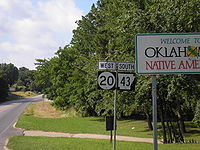
The easternmost miles run north/south along the Oklahoma–Arkansas state line, and along this stretch the highway overlaps
Arkansas's Highway 43. This is the only place where two state highways from different states overlap. The highway continues northward into Missouri at the point where the Oklahoma, Arkansas and Missouri borders meet, and thereafter becomes Missouri Route 43. This unique feature has led many roadgeek
s to mention SH-20/AR-43 on their websites.
near Keetonville
, west of Claremore
, was closed due to a landside caused by heavy rains. A 500 feet (152.4 m) section of roadbed was washed away, forming a large crack in the pavement and damaging the guardrail. The highway was re-opened June 5, 2008 after being repaired.
Oklahoma
Oklahoma is a state located in the South Central region of the United States of America. With an estimated 3,751,351 residents as of the 2010 census and a land area of 68,667 square miles , Oklahoma is the 28th most populous and 20th-largest state...
. Its eastern terminus is at the corner of Oklahoma, Arkansas
Arkansas
Arkansas is a state located in the southern region of the United States. Its name is an Algonquian name of the Quapaw Indians. Arkansas shares borders with six states , and its eastern border is largely defined by the Mississippi River...
, and Missouri
Missouri
Missouri is a US state located in the Midwestern United States, bordered by Iowa, Illinois, Kentucky, Tennessee, Arkansas, Oklahoma, Kansas and Nebraska. With a 2010 population of 5,988,927, Missouri is the 18th most populous state in the nation and the fifth most populous in the Midwest. It...
near Southwest City, Missouri
Southwest City, Missouri
Southwest City is a city in McDonald County, Missouri, United States. The population was 937 at the 2009 census, at which time it was a town. It is part of the Fayetteville–Springdale–Rogers, AR-MO Metropolitan Statistical Area.-Geography:...
; its western terminus is at State Highway 18
State Highway 18 (Oklahoma)
State Highway 18, abbreviated as SH-18 or OK-18, is a highway maintained by the U.S. state of Oklahoma. It was once one of the longest state highways in the Oklahoma road system, but now has a total length of .-Route description:...
near Ralston
Ralston, Oklahoma
Ralston is a town in Pawnee County, Oklahoma, United States. The population was 355 at the 2000 census.-Geography:Ralston is located at . According to the United States Census Bureau, the town has a total area of , all of it land....
. The highway runs a total length of 143.8 miles It has no lettered spur routes.
Route description
Arkansas River
The Arkansas River is a major tributary of the Mississippi River. The Arkansas generally flows to the east and southeast as it traverses the U.S. states of Colorado, Kansas, Oklahoma, and Arkansas. The river's initial basin starts in the Western United States in Colorado, specifically the Arkansas...
at SH-18 near Ralston. From there, it heads east through Osage County
Osage County, Oklahoma
Osage County is a county in the northern part of the U.S. state of Oklahoma. Coterminous with the Osage Indian Reservation, it is the home of the federally recognized Osage Nation. As of the 2010 census, the population was 47,472 a 6.8 percent increase from 2000, when the population was 44,437...
for twenty miles (32 km) without crossing any other highway. At mile 20.4, it meets State Highway 99
State Highway 99 (Oklahoma)
State Highway 99, also referred to as SH-99 or OK-99, is a north–south state highway through central Oklahoma. It runs from the Texas border at Lake Texoma to the Kansas border near Lake Hulah. It is long. The highway overlaps US-377 for over half its length.SH-99 links up with K-99 after...
in Hominy
Hominy, Oklahoma
Hominy is a city in Osage County, Oklahoma, United States. The population was 3,565 at the 2010 census, a 38 percent increase from 2,584 at the 2000 census.-Geography:Hominy is located at ....
. East of Hominy, SH-20 crosses Lake Skiatook before passing through Skiatook
Skiatook, Oklahoma
Skiatook is a town in Osage and Tulsa counties in the U.S. state of Oklahoma. Located in the northeastern part of the state, it is a suburb of Tulsa. The population was 7,397 in the 2010 census, compared to 5,396 at the 2000 census.-History:William C...
and entering Tulsa County
Tulsa County, Oklahoma
Tulsa County is a county located in the U.S. state of Oklahoma. According to the 2010 U.S. Census, the population is 603,403. Its county seat is Tulsa.-History of Tulsa County:The history of Tulsa County greatly overlaps the history of the city of Tulsa...
. Shortly after entering Tulsa County, SH-20 has a junction with SH-11. Four miles later, it has an interchange with US-75. After running through Collinsville
Collinsville, Oklahoma
Collinsville is a city in Rogers and Tulsa counties in the U.S. state of Oklahoma, and a part of the Tulsa, Oklahoma Metropolitan Statistical Area. It was named for Dr. A. H. Collins, an engineer and surveyor who first surveyed the land that became this community...
, it turns southward onto the US-169 freeway.
SH-20 splits from US-169 north of Owasso
Owasso, Oklahoma
Owasso is a city in Rogers and Tulsa counties in the U.S. state of Oklahoma, and a northern suburb of Tulsa. The population was 28,915 at the 2010 census.-Geography:Owasso is located at...
. It then enters Claremore
Claremore, Oklahoma
Claremore is a city and the county seat of Rogers County, Oklahoma, United States. The population was 18,581 at the 2010 census, a 17.1 percent increase from 15,873 at the 2000 census. It is part of the Tulsa Metropolitan Area and home to Rogers State University...
, where it meets SH-88
Oklahoma State Highway 88
State Highway 88, abbreviated to SH-88 or OK-88, is a state highway in Oklahoma. It runs for 26.0 miles north–south through Rogers County. It has no lettered spur routes.SH-88 dates back to 1940 or early 1941....
and SH-66 (old Route 66). It connects to the Claremore toll plaza on I-44/Will Rogers Turnpike
Will Rogers Turnpike
The Will Rogers Turnpike is a toll road in northeast Oklahoma that runs from Tulsa, Oklahoma to the Missouri state line. It is long and costs $4.00 to drive one way...
. East of Claremore, SH-20 becomes a divided expressway before intersecting US-69 in Pryor. West of Salina
Salina, Oklahoma
Salina is a town in Mayes County, Oklahoma, United States. The population was 1,396 at the 2010 census, a slight decline from 1,422 at the 2000 census.-History:...
,the highway bridges Lake Hudson
Lake Hudson (Oklahoma)
Note: The Robert S. Kerr Dam described in this article should not be confused with the Robert S. Kerr Lock and Dam on the Arkansas River ....
. In Salina, SH-20 meets SH-82
Oklahoma State Highway 82
State Highway 82, abbreviated to SH-82 or OK-82, is a state highway in Oklahoma. It runs for 49.4 miles north–south during its southern segment; and 99.5 miles north–south during its northern segment....
, which it begins a concurrency with.
Headed north from Salina, the two highways begin to cross some mountainous terrain. The highways provide access to Spavinaw State Park, before running through the town of Spavinaw, Oklahoma
Spavinaw, Oklahoma
Spavinaw is a town in Mayes County, Oklahoma, United States. The population was 563 at the 2000 census. The town is best known as the birthplace of baseball player Mickey Mantle.-Geography:Spavinaw is located at ....
. North of Spavinaw, SH-20 splits off to the east, running through unincorporated Chloeta
Chloeta, Oklahoma
Chloeta is a small rural community located on State Highway 20 in Delaware County, Oklahoma, north of Spavinaw Lake. The post office existed from April 18, 1898, until January 31, 1914.-Sources:...
and serving as the eastern terminus of SH-28. SH-20 overlaps US-59/State Highway 10 through Jay
Jay, Oklahoma
Jay is a city in Delaware County, Oklahoma, United States. The population was 2,448 at the 2010 census, compared to 2,482 at the 2000 census, a decrease of 1.4 percent. Almost 40% of Jay residents are Native American...
. SH-20 then splits off to the east, running 11 miles (17.7 km) to the Arkansas line.
The easternmost miles run north/south along the Oklahoma–Arkansas state line, and along this stretch the highway overlaps
Concurrency (road)
A concurrency, overlap, or coincidence in a road network is an instance of one physical road bearing two or more different highway, motorway, or other route numbers...
Arkansas's Highway 43. This is the only place where two state highways from different states overlap. The highway continues northward into Missouri at the point where the Oklahoma, Arkansas and Missouri borders meet, and thereafter becomes Missouri Route 43. This unique feature has led many roadgeek
Roadgeek
A roadgeek is an individual involved in "roadgeeking" or "road enthusiasm"—an interest in roads, and especially going on road trips, as a hobby...
s to mention SH-20/AR-43 on their websites.
History
On April 10, 2008, a section of SH-20 in Rogers CountyRogers County, Oklahoma
Rogers County is a county located in the U.S. state of Oklahoma. As of 2010, the population was 86,905. Its county seat is Claremore. The county was originally created in 1906 and named Cooweescoowee...
near Keetonville
Keetonville, Oklahoma
Keetonville is a small rural community in Rogers County, Oklahoma, roughly 5 miles west of Claremore and 8 miles east of German Corner on Highway 20 in Rogers County;Location is 36°18'23"N 95°42'29"W; elevation is 628 feet-External links:* *...
, west of Claremore
Claremore, Oklahoma
Claremore is a city and the county seat of Rogers County, Oklahoma, United States. The population was 18,581 at the 2010 census, a 17.1 percent increase from 15,873 at the 2000 census. It is part of the Tulsa Metropolitan Area and home to Rogers State University...
, was closed due to a landside caused by heavy rains. A 500 feet (152.4 m) section of roadbed was washed away, forming a large crack in the pavement and damaging the guardrail. The highway was re-opened June 5, 2008 after being repaired.