
Standing Stone State Park
Encyclopedia
Standing Stone State Park is a state park
in Overton County, Tennessee, in the southeastern United States. The park consists of 855 acres (3.5 km²) along the shoreline of the man-made 69 acre (0.27923334 km²) Standing Stone Lake. The 11000 acres (44.5 km²) Standing Stone State Forest surrounds the park.
The park and forest were developed in the 1930s as part of New Deal
-era initiatives to relocate impoverished farmers and restore forests to degraded and heavily eroded lands. The park was named after the Standing Stone, a mysterious rock believed to be of Native American
origin or importance that once stood along the old Walton Road at what is now Monterey
. The park offers canoeing, camping, lodging, hiking and many other activities.
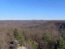 Standing Stone State Park is situated atop the eastern section of the Highland Rim
, a plateau-like upland that surrounds the Nashville Basin
. The park is located roughly halfway between the rim's edge along the basin to the west and the higher Cumberland Plateau
to the east. The Dale Hollow Lake impoundment of the Obey River
dominates the area just a few miles to the north.
Mill Creek, the park's major stream, flows down from its source on Reynolds Mountain (near Allons) to the east and winds its way westward through the hills of northern Overton County before emptying into the Cumberland River
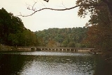
. At Standing Stone State Park, the steep ridge upon which the park's main facilities are located briefly pushes the westward-flowing Mill Creek southward through a horseshoe bend. At this bend, two of Mill Creek's tributaries, Morgan Creek and Bryans Fork, join Mill Creek at the southeast and southwest, respectively, to form a natural X-shaped body of water. Standing Stone Dam impounds the creek immediately downstream from the bend, forming the X-shaped Standing Stone Lake. Ridges and high hills rise above the lake on all sides, namely 1455 feet (443.5 m) Cooper Mountain to the east and 1493 feet (455.1 m) Goodpasture Mountain to the southwest.
Tennessee State Route 136, which runs north-to-south, traverses Standing Stone State Park. The road intersects the east-west Tennessee State Route 85 at the community of Hilham
just south of the park and intersects the east-west Tennessee State Route 52 just north of the park. Beyond Hilham, TN-136 continues southward to Cookeville
, where it intersects Interstate 40
. The town of Livingston
, where TN-52 and TN-85 intersect, is just southeast of the park.
 Standing Stone State Park is surrounded by Standing Stone State Forest, which is managed by the Tennessee Division of Forestry. Unlike the state park, the state forest does not have recreational facilities, although public access is permitted. The boundary between the state forest and state park is clearly marked with signs, blazes, or ribbons.
When the United States Department of Agriculture
acquired the land for Standing Stone State Forest in the 1930s, the forest had been damaged and depleted by forest fires, logging, and poor farming practices such as row cropping. Standing Stone was designated a state forest in 1961, six years after the U.S. government officially deeded the land to the State of Tennessee. The forest consists of 89% upland hardwoods, 6.8% pine, and 4% mixed hardwood and pine. 34% of the trees in the forest are over 80 years old, 48% are between 50 and 80 years old, and 18% are less than 50 years old.
were living in substantial semi-permanent villages and rock shelters in Northern Overton County as early as the Archaic period (c. 8000-1000 B.C.). According to Native American legends, the Overton area was part of a vast region long disputed by Algonquian-speaking
tribes (such as the Shawnee
) and Iroquoian-speaking
tribes (such as the Cherokee
). By the time the first Euro-American explorers arrived in Overton County in the mid-18th century, the Cherokee were in control of the area. The Cherokee chief Nettle Carrier operated out of a camp located along the creek that now bears his name a few miles east of the park.
Long hunters
, who were among the first Euro-Americans to explore the Middle Tennessee region, were active in the Standing Stone area as early as the 1760s. These hunters were drawn to the region by the Cumberland River, the headwaters of which they followed westward from Virginia
. Daniel Boone
and Richard Callaway
are believed to have camped at the mouth of Mill Creek around 1763. A few years later, a long hunting expedition led by Kasper Mansker camped in the Oak Hill area, near modern Livingston. While at Oak Hill, a member of Mansker's expedition named Robert Crockett was ambushed and killed by hostile Cherokees.
The park's namesake was a mysterious stone which according to the region's earliest pioneers was revered by Native Americans. William Walton discovered the stone at what is now Monterey
(appx. 20 miles (32.2 km) southeast of the park) in the late 1780s while building the Walton Road. The stone originally stood around 10 feet (3 m) tall and was shaped like a dog sitting on its hind legs. The purpose of the stone, if any, remains unknown. Some accounts claim that the stone marked the boundary between the territories of the Cherokee and Shawnee, or other Native American tribes. Others say it was a guidepost used by Cherokee hunting parties. Whatever its original purpose, the stone was a well-known landmark for migrants travelling between East and Middle Tennessee in the early 19th century. A community known as "Standing Stone" (later renamed Monterey) developed along the Walton Road in the stone's vicinity. The Standing Stone was dynamited in 1893 to make way for railroad construction. Shortly after it was destroyed, a local society known as the Improved Order of the Redmen retrieved and preserved several pieces of the stone. In 1895, the order placed one of these pieces (which they had engraved) atop a monument at Monterey City Park, where it remains today.
-era projects of the Works Project Administration and the Resettlement Administration
aimed at relocating impoverished farmers living on badly eroded lands and restoring the forests to these lands. Work began in 1935 with a three-fold purpose— relocating farmers in the Mill Creek area, restoring the forest and controlling erosion, and creating recreational opportunities for area residents. The work was carried out by the Resettlement Administration, the WPA, and the Civilian Conservation Corps
under the general supervision of the United States Forest Service
. The land was leased to the Tennessee Division of State Parks in 1939.
During World War II
, development was largely halted and many of the park's facilities fell into disrepair. After the war, the cabins were renovated, the lake was drained and restocked with fish, and a major leak in the dam was repaired. The United States Department of Agriculture officially deeded the land to the State of Tennessee in 1955.
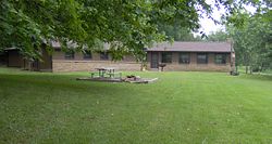 Recreational facilities at Standing Stone State Park include a 36-site campground, 21 cabins ranging from rustic to modern, four group lodges, an Olympic-size pool, multiple picnic areas, and an amphiteatre. Most of these facilities (along with the visitor center) are located atop the steep ridge on the north shore of the lake. The lone exception is Overton Lodge, one of the four group lodges, which is located along the lake's east shore.
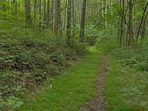
Over 8 miles (12.9 km) of hiking trails are maintained in the park and forest. The most popular trail is the Lake Trail, which descends from the visitor center to Standing Stone Dam and parallels most of the north shore of the lake before reascending to the cabin area. The most substantial trail is the 8 miles (12.9 km) Cooper Mountain Loop Trail, which circles through several miles of the state forest on the slopes of Cooper Mountain before reentering the state park near Overton Lodge.
The National Rolley Hole Marbles Championship is held every September at Standing Stone State Park. Rolley hole is a type of marbles
game popular with marble enthusiasts in the Tennessee-Kentucky region. Other annual events include the Spring Naturalist Rally in April and the Standing Stone Car Show in October.
State park
State parks are parks or other protected areas managed at the federated state level within those nations which use "state" as a political subdivision. State parks are typically established by a state to preserve a location on account of its natural beauty, historic interest, or recreational...
in Overton County, Tennessee, in the southeastern United States. The park consists of 855 acres (3.5 km²) along the shoreline of the man-made 69 acre (0.27923334 km²) Standing Stone Lake. The 11000 acres (44.5 km²) Standing Stone State Forest surrounds the park.
The park and forest were developed in the 1930s as part of New Deal
New Deal
The New Deal was a series of economic programs implemented in the United States between 1933 and 1936. They were passed by the U.S. Congress during the first term of President Franklin D. Roosevelt. The programs were Roosevelt's responses to the Great Depression, and focused on what historians call...
-era initiatives to relocate impoverished farmers and restore forests to degraded and heavily eroded lands. The park was named after the Standing Stone, a mysterious rock believed to be of Native American
Native Americans in the United States
Native Americans in the United States are the indigenous peoples in North America within the boundaries of the present-day continental United States, parts of Alaska, and the island state of Hawaii. They are composed of numerous, distinct tribes, states, and ethnic groups, many of which survive as...
origin or importance that once stood along the old Walton Road at what is now Monterey
Monterey, Tennessee
Monterey is a town in Putnam County, Tennessee, United States. The population was 2,717 at the 2000 census. It is part of the Cookeville, Tennessee Micropolitan Statistical Area.-Geography:Monterey is located at ....
. The park offers canoeing, camping, lodging, hiking and many other activities.
Geographical setting
Highland Rim
The Highland Rim is a geographic term for the area in Tennessee surrounding the Central Basin. Nashville is largely surrounded by higher terrain in all directions....
, a plateau-like upland that surrounds the Nashville Basin
Nashville Basin
The Nashville Basin, also known as the Central Basin, is a term often used to describe the area surrounding Nashville, Tennessee. The Central Basin was caused by an uplifting known as the Nashville Dome. The Nashville Dome is evidenced by the underlying rock strata that all dip downwards away from...
. The park is located roughly halfway between the rim's edge along the basin to the west and the higher Cumberland Plateau
Cumberland Plateau
The Cumberland Plateau is the southern part of the Appalachian Plateau. It includes much of eastern Kentucky and western West Virginia, part of Tennessee, and a small portion of northern Alabama and northwest Georgia . The terms "Allegheny Plateau" and the "Cumberland Plateau" both refer to the...
to the east. The Dale Hollow Lake impoundment of the Obey River
Obey River
The Obey River is a tributary of the Cumberland River in the U.S. state of Tennessee. It joins the Cumberland River near the town of Celina, which is generally considered to be the Cumberland's head of navigation. Via the Cumberland and Ohio rivers, the Obey River is part of the Mississippi River...
dominates the area just a few miles to the north.
Mill Creek, the park's major stream, flows down from its source on Reynolds Mountain (near Allons) to the east and winds its way westward through the hills of northern Overton County before emptying into the Cumberland River
Cumberland River
The Cumberland River is a waterway in the Southern United States. It is long. It starts in Harlan County in far southeastern Kentucky between Pine and Cumberland mountains, flows through southern Kentucky, crosses into northern Tennessee, and then curves back up into western Kentucky before...
. At Standing Stone State Park, the steep ridge upon which the park's main facilities are located briefly pushes the westward-flowing Mill Creek southward through a horseshoe bend. At this bend, two of Mill Creek's tributaries, Morgan Creek and Bryans Fork, join Mill Creek at the southeast and southwest, respectively, to form a natural X-shaped body of water. Standing Stone Dam impounds the creek immediately downstream from the bend, forming the X-shaped Standing Stone Lake. Ridges and high hills rise above the lake on all sides, namely 1455 feet (443.5 m) Cooper Mountain to the east and 1493 feet (455.1 m) Goodpasture Mountain to the southwest.
Tennessee State Route 136, which runs north-to-south, traverses Standing Stone State Park. The road intersects the east-west Tennessee State Route 85 at the community of Hilham
Hilham, Tennessee
Hilham is an unincorporated community in Overton County, Tennessee, in the southeastern United States. The community is centered around the junction of Tennessee State Route 136 and Tennessee State Route 85...
just south of the park and intersects the east-west Tennessee State Route 52 just north of the park. Beyond Hilham, TN-136 continues southward to Cookeville
Cookeville, Tennessee
Cookeville is a city in Putnam County, Tennessee, United States. The population was 23,923 at the 2000 census. of Cookeville's population was 30,435, and the combined total of those living in Cookeville's in 2010 was 65,014. It is the county seat of Putnam County and home to Tennessee...
, where it intersects Interstate 40
Interstate 40
Interstate 40 is the third-longest major east–west Interstate Highway in the United States, after I-90 and I-80. Its western end is at Interstate 15 in Barstow, California; its eastern end is at a concurrency of U.S. Route 117 and North Carolina Highway 132 in Wilmington, North Carolina...
. The town of Livingston
Livingston, Tennessee
Livingston is a town in Overton County, Tennessee, United States. The population was 3,498 at the 2000 census. It is the county seat of Overton County...
, where TN-52 and TN-85 intersect, is just southeast of the park.
Standing Stone State Forest
When the United States Department of Agriculture
United States Department of Agriculture
The United States Department of Agriculture is the United States federal executive department responsible for developing and executing U.S. federal government policy on farming, agriculture, and food...
acquired the land for Standing Stone State Forest in the 1930s, the forest had been damaged and depleted by forest fires, logging, and poor farming practices such as row cropping. Standing Stone was designated a state forest in 1961, six years after the U.S. government officially deeded the land to the State of Tennessee. The forest consists of 89% upland hardwoods, 6.8% pine, and 4% mixed hardwood and pine. 34% of the trees in the forest are over 80 years old, 48% are between 50 and 80 years old, and 18% are less than 50 years old.
History
Native AmericansNative Americans in the United States
Native Americans in the United States are the indigenous peoples in North America within the boundaries of the present-day continental United States, parts of Alaska, and the island state of Hawaii. They are composed of numerous, distinct tribes, states, and ethnic groups, many of which survive as...
were living in substantial semi-permanent villages and rock shelters in Northern Overton County as early as the Archaic period (c. 8000-1000 B.C.). According to Native American legends, the Overton area was part of a vast region long disputed by Algonquian-speaking
Algonquian languages
The Algonquian languages also Algonkian) are a subfamily of Native American languages which includes most of the languages in the Algic language family. The name of the Algonquian language family is distinguished from the orthographically similar Algonquin dialect of the Ojibwe language, which is a...
tribes (such as the Shawnee
Shawnee
The Shawnee, Shaawanwaki, Shaawanooki and Shaawanowi lenaweeki, are an Algonquian-speaking people native to North America. Historically they inhabited the areas of Ohio, Virginia, West Virginia, Western Maryland, Kentucky, Indiana, and Pennsylvania...
) and Iroquoian-speaking
Iroquoian languages
The Iroquoian languages are a First Nation and Native American language family.-Family division:*Ruttenber, Edward Manning. 1992 [1872]. History of the Indian tribes of Hudson's River. Hope Farm Press....
tribes (such as the Cherokee
Cherokee
The Cherokee are a Native American people historically settled in the Southeastern United States . Linguistically, they are part of the Iroquoian language family...
). By the time the first Euro-American explorers arrived in Overton County in the mid-18th century, the Cherokee were in control of the area. The Cherokee chief Nettle Carrier operated out of a camp located along the creek that now bears his name a few miles east of the park.
Long hunters
Longhunter
A Longhunter was an 18th-century explorer and hunter who made expeditions into the American frontier wilderness for as much as six months at a time...
, who were among the first Euro-Americans to explore the Middle Tennessee region, were active in the Standing Stone area as early as the 1760s. These hunters were drawn to the region by the Cumberland River, the headwaters of which they followed westward from Virginia
Virginia
The Commonwealth of Virginia , is a U.S. state on the Atlantic Coast of the Southern United States. Virginia is nicknamed the "Old Dominion" and sometimes the "Mother of Presidents" after the eight U.S. presidents born there...
. Daniel Boone
Daniel Boone
Daniel Boone was an American pioneer, explorer, and frontiersman whose frontier exploits mad']'e him one of the first folk heroes of the United States. Boone is most famous for his exploration and settlement of what is now the Commonwealth of Kentucky, which was then beyond the western borders of...
and Richard Callaway
Richard Callaway
Richard Callaway was an early settler of Kentucky. Born in Caroline County, Virginia, Callaway joined Daniel Boone in 1775 in marking the Wilderness Road into central Kentucky, becoming one of the founders of Boonesborough, Kentucky...
are believed to have camped at the mouth of Mill Creek around 1763. A few years later, a long hunting expedition led by Kasper Mansker camped in the Oak Hill area, near modern Livingston. While at Oak Hill, a member of Mansker's expedition named Robert Crockett was ambushed and killed by hostile Cherokees.
The park's namesake was a mysterious stone which according to the region's earliest pioneers was revered by Native Americans. William Walton discovered the stone at what is now Monterey
Monterey, Tennessee
Monterey is a town in Putnam County, Tennessee, United States. The population was 2,717 at the 2000 census. It is part of the Cookeville, Tennessee Micropolitan Statistical Area.-Geography:Monterey is located at ....
(appx. 20 miles (32.2 km) southeast of the park) in the late 1780s while building the Walton Road. The stone originally stood around 10 feet (3 m) tall and was shaped like a dog sitting on its hind legs. The purpose of the stone, if any, remains unknown. Some accounts claim that the stone marked the boundary between the territories of the Cherokee and Shawnee, or other Native American tribes. Others say it was a guidepost used by Cherokee hunting parties. Whatever its original purpose, the stone was a well-known landmark for migrants travelling between East and Middle Tennessee in the early 19th century. A community known as "Standing Stone" (later renamed Monterey) developed along the Walton Road in the stone's vicinity. The Standing Stone was dynamited in 1893 to make way for railroad construction. Shortly after it was destroyed, a local society known as the Improved Order of the Redmen retrieved and preserved several pieces of the stone. In 1895, the order placed one of these pieces (which they had engraved) atop a monument at Monterey City Park, where it remains today.
Development of the park
Standing Stone State Park was one of a series of New DealNew Deal
The New Deal was a series of economic programs implemented in the United States between 1933 and 1936. They were passed by the U.S. Congress during the first term of President Franklin D. Roosevelt. The programs were Roosevelt's responses to the Great Depression, and focused on what historians call...
-era projects of the Works Project Administration and the Resettlement Administration
Resettlement Administration
The Resettlement Administration was a U.S. federal agency that, between April 1935 and December 1936, relocated struggling urban and rural families to communities planned by the federal government....
aimed at relocating impoverished farmers living on badly eroded lands and restoring the forests to these lands. Work began in 1935 with a three-fold purpose— relocating farmers in the Mill Creek area, restoring the forest and controlling erosion, and creating recreational opportunities for area residents. The work was carried out by the Resettlement Administration, the WPA, and the Civilian Conservation Corps
Civilian Conservation Corps
The Civilian Conservation Corps was a public work relief program that operated from 1933 to 1942 in the United States for unemployed, unmarried men from relief families, ages 18–25. A part of the New Deal of President Franklin D...
under the general supervision of the United States Forest Service
United States Forest Service
The United States Forest Service is an agency of the United States Department of Agriculture that administers the nation's 155 national forests and 20 national grasslands, which encompass...
. The land was leased to the Tennessee Division of State Parks in 1939.
During World War II
World War II
World War II, or the Second World War , was a global conflict lasting from 1939 to 1945, involving most of the world's nations—including all of the great powers—eventually forming two opposing military alliances: the Allies and the Axis...
, development was largely halted and many of the park's facilities fell into disrepair. After the war, the cabins were renovated, the lake was drained and restocked with fish, and a major leak in the dam was repaired. The United States Department of Agriculture officially deeded the land to the State of Tennessee in 1955.
Park facilities and events
Over 8 miles (12.9 km) of hiking trails are maintained in the park and forest. The most popular trail is the Lake Trail, which descends from the visitor center to Standing Stone Dam and parallels most of the north shore of the lake before reascending to the cabin area. The most substantial trail is the 8 miles (12.9 km) Cooper Mountain Loop Trail, which circles through several miles of the state forest on the slopes of Cooper Mountain before reentering the state park near Overton Lodge.
The National Rolley Hole Marbles Championship is held every September at Standing Stone State Park. Rolley hole is a type of marbles
Marbles
A marble is a small spherical toy usually made from glass, clay, steel, or agate. These balls vary in size. Most commonly, they are about ½ inch in diameter, but they may range from less than ¼ inch to over 3 inches , while some art glass marbles fordisplay purposes are over 12 inches ...
game popular with marble enthusiasts in the Tennessee-Kentucky region. Other annual events include the Spring Naturalist Rally in April and the Standing Stone Car Show in October.
External links
- Standing Stone State Park — official website