St John's in the Vale
Encyclopedia

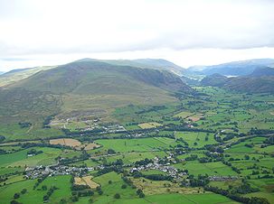
U-shaped valley
A U-shaped valley also known as a glacial trough is one formed by the process of glaciation. It has a characteristic U-shape, with steep, straight sides, and a flat bottom. Glaciated valleys are formed when a glacier travels across and down a slope, carving the valley by the action of scouring...
in the Lake District National Park
Lake District National Park
The Lake District National Park is located in the north-west of England and is the largest of the English National Parks and the second largest in the United Kingdom. It is in the central and most-visited part of the Lake District....
, Cumbria
Cumbria
Cumbria , is a non-metropolitan county in North West England. The county and Cumbria County Council, its local authority, came into existence in 1974 after the passage of the Local Government Act 1972. Cumbria's largest settlement and county town is Carlisle. It consists of six districts, and in...
, England
England
England is a country that is part of the United Kingdom. It shares land borders with Scotland to the north and Wales to the west; the Irish Sea is to the north west, the Celtic Sea to the south west, with the North Sea to the east and the English Channel to the south separating it from continental...
. Within the vale are a number of farms and small settlements, in addition to several disused quarry
Quarry
A quarry is a type of open-pit mine from which rock or minerals are extracted. Quarries are generally used for extracting building materials, such as dimension stone, construction aggregate, riprap, sand, and gravel. They are often collocated with concrete and asphalt plants due to the requirement...
and mining
Mining
Mining is the extraction of valuable minerals or other geological materials from the earth, from an ore body, vein or seam. The term also includes the removal of soil. Materials recovered by mining include base metals, precious metals, iron, uranium, coal, diamonds, limestone, oil shale, rock...
works. St Johns Beck meander
Meander
A meander in general is a bend in a sinuous watercourse. A meander is formed when the moving water in a stream erodes the outer banks and widens its valley. A stream of any volume may assume a meandering course, alternately eroding sediments from the outside of a bend and depositing them on the...
s northward along the floor of the vale, and is the primary route of outflow from Thirlmere
Thirlmere
Thirlmere is a reservoir in the Borough of Allerdale in Cumbria and the English Lake District. It runs roughly south to north, with a dam at the northern end, and is bordered on the eastern side by the A591 road and on the western side by a minor road....
reservoir to the south. Alongside the beck runs the B5322, St Johns in the Vale Road.
The vale is in the heart of the northern Lake District and is surrounded by many of the most striking of the Lakeland fell
Fell
“Fell” is a word used to refer to mountains, or certain types of mountainous landscape, in Scandinavia, the Isle of Man, and parts of northern England.- Etymology :...
s. It runs from south to north, set between the rocky flanks of Clough Head
Clough Head
Clough Head is a fell in the English Lake District. It is the northernmost top of the Helvellyn range in the Eastern Fells, standing to the south of Threlkeld and the A66.-Topography:...
to the east and the neighbours High Rigg
High Rigg
High Rigg is a small fell located in the English Lake District, approximately three miles southeast of the town of Keswick. It occupies an unusual position, surrounded on all sides by higher fells but not connected by any obvious ridge...
and Low Rigg
Low Rigg
Low Rigg is a small hill located in the English Lake District a few miles east of the town of Keswick and slightly to the north of its larger neighbour High Rigg. It is a hill of modest elevation, being of insufficient size to merit inclusion in the famous Lake District guides produced by Alfred...
to the west. The southern end of the vale is a narrow pass between High Rigg and Great Dodd
Great Dodd
Great Dodd is a fell in the English Lake District. It stands on the main spine of the Helvellyn range in the Eastern Fells, between the Vale of St John and Dockray.-Topography:...
, just to the north of the small settlement of Legburthwaite
Legburthwaite
Legburthwaite is a village in the Allerdale District, in the county of Cumbria. It is located on the A591 road and the B5322 road. Legburthwaite has a place of worship and a youth hostel. It is just north of Thirlmere.- References :...
. At its northern end the vale widens to meet the broad east-to-west valley of the River Greta near Threlkeld
Threlkeld
Threlkeld is a village and civil parish in the north of the Lake District in Cumbria, England, to the east of Keswick. It lies at the southern foot of Blencathra, one of the more prominent fells in the northern Lake District, and to the north of the River Glenderamackin.Historically a part of...
. The view north from the vale is dominated by the mountains Blencathra
Blencathra
Blencathra, also known as Saddleback, is one of the most northerly mountains in the English Lake District. It has six separate fell tops, of which the highest is the Hallsfell Top.-Name:...
and Skiddaw
Skiddaw
Skiddaw is a mountain in the Lake District National Park in England. With a summit at 931 m above sea level it is the fourth highest mountain in England. It lies just north of the town of Keswick, Cumbria, and dominates the skyline in this part of the northern lakes...
.
High on the western side of the vale lies St Johns in the Vale Church, located in a low pass between High Rigg on the southern side and Low Rigg to the north. This pass provides access for suitably capable vehicles between the vale and Dale Bottom in the Naddle
Naddle Beck
Naddle Beck is a minor river of Cumbria, England.Rising beneath Dodd Crag, Naddle Beck flows northward to meet the River Greta.The major tributary of Naddle Beck is Shoulthwaite Gill, which drains the eastern side of High Seat and Bleaberry Fell. Mere Gill joins Shoulthwaite Gill beneath an old...
Valley to the west of High Rigg. The present building dates from 1845, with the earliest reference to a church at the site being 1554. On the opposite side of the vale, cut into the northern flank of Clough Head, lies the Threlkeld Quarry and Mining Museum. This former commercial quarry, first opened in the late nineteenth century, was established as a museum in 1992.