
South Hwanghae
Encyclopedia
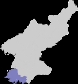
South Hwanghae is a province
in western North Korea
. The province was formed in 1954 when the former Hwanghae
Province was split into North and South Hwanghae. The provincial capital is Haeju
.
, and is bounded on the west by the Yellow Sea
, on the north and east by North Hwanghae province. There are some administrative exclaves of Nampo
City in the north of the province. The southern border of the province is marked by the Korean Demilitarized Zone
with South Korea
. The province draws its name from what were the largest cities in Hwanghae, Haeju
and Hwangju
; the name, which literally means "Yellow Sea" in Korean
, also references the Yellow Sea, which forms the province's eastern bound.
The coastline of South Hwanghae is dotted by many small islands, many of which are uninhabited. Many of the largest islands, such as Baengnyeong-do are administered by South Korea. The Northern Limit Line
, which runs through the region and demarcates the maritime boundary
between the north and south, is another frequent subject of contention between the two countries. The largest islands which indisputably belong to North Korea are Kirin-do, Changrin-do, and Sunwi-do.
The province, being not very mountainous, is uniquely suited to farming, and is thus often referred to as the "bread-basket" of North Korea. Much of the land is devoted to farming, and thus was not hit as hard as other parts of the country during the Arduous March of the 1990s. Many types of vegetables, fruits, grains, and rice are grown on the plains of the region; Kwail
County, which means fruit in Korean, was founded with the express purpose of growing orchards.
Haeju
, the provincial capital, is also the largest port in southern North Korea outside of Wonsan
. The area is also home to several ancient burial mounds and cultural relics, such as the Kangsosa Buddhist temple, ancient stone pagodas, and a Koryo-era ice house. There are also many Iron Age dolmen and Koguryo tombs in the province, such as Anak Tomb No. 3
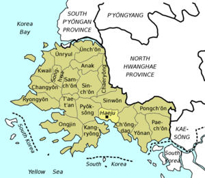 South Hwanghae is divided into 1 city (si) and 19 counties (gun). These are further divided into villages (ri) in rural areas and dong (neighborhoods) in cities, which are detailed on each county’s individual page.
Administrative divisions of North Korea
The administrative divisions of North Korea are organized into three hierarchical levels. Many of the units have equivalents in the system of South Korea. At the highest level are nine provinces, two directly governed cities, and three special administrative divisions. The second-level divisions...
in western North Korea
North Korea
The Democratic People’s Republic of Korea , , is a country in East Asia, occupying the northern half of the Korean Peninsula. Its capital and largest city is Pyongyang. The Korean Demilitarized Zone serves as the buffer zone between North Korea and South Korea...
. The province was formed in 1954 when the former Hwanghae
Hwanghae
Hwanghae was one of the Eight Provinces of Korea during the Joseon Dynasty. Hwanghae was located in the northwest of Korea. The provincial capital was Haeju.The regional name for the province was Haesŏ .-History:...
Province was split into North and South Hwanghae. The provincial capital is Haeju
Haeju
Haeju is a city located in South Hwanghae Province near Haeju Bay in North Korea. It is the administrative centre of South Hwanghae Province. As of 2000, the population of the city is estimated to be 236,000. At the beginning of 20th century, it became a strategic port in Sino-Korean trade...
.
Geography
The province is part of the Haeso regionRegions of Korea
Korea has traditionally been divided into a number of unofficial regions that reflect historical, geographical, and dialect boundaries within the peninsula...
, and is bounded on the west by the Yellow Sea
Yellow Sea
The Yellow Sea is the name given to the northern part of the East China Sea, which is a marginal sea of the Pacific Ocean. It is located between mainland China and the Korean Peninsula. Its name comes from the sand particles from Gobi Desert sand storms that turn the surface of the water golden...
, on the north and east by North Hwanghae province. There are some administrative exclaves of Nampo
Nampo
Namp'o is a city and seaport in South P'yŏngan Province, North Korea. It was a provincial-level Directly Governed City from 1980 to 2004, when it was designated a "Special City" and made a part of South P'yŏngan...
City in the north of the province. The southern border of the province is marked by the Korean Demilitarized Zone
Korean Demilitarized Zone
The Korean Demilitarized Zone is a strip of land running across the Korean Peninsula that serves as a buffer zone between North and South Korea. The DMZ cuts the Korean Peninsula roughly in half, crossing the 38th parallel on an angle, with the west end of the DMZ lying south of the parallel and...
with South Korea
South Korea
The Republic of Korea , , is a sovereign state in East Asia, located on the southern portion of the Korean Peninsula. It is neighbored by the People's Republic of China to the west, Japan to the east, North Korea to the north, and the East China Sea and Republic of China to the south...
. The province draws its name from what were the largest cities in Hwanghae, Haeju
Haeju
Haeju is a city located in South Hwanghae Province near Haeju Bay in North Korea. It is the administrative centre of South Hwanghae Province. As of 2000, the population of the city is estimated to be 236,000. At the beginning of 20th century, it became a strategic port in Sino-Korean trade...
and Hwangju
Hwangju
-Geography:Hwangju is bordered to the northwest by Sariwŏn, to the northeast by Songrim and Kangnam, to the southwest by Yŏnt'an, to the south by Pongsan, and to the southeast by Ŭnch'ŏn-History:...
; the name, which literally means "Yellow Sea" in Korean
Korean language
Korean is the official language of the country Korea, in both South and North. It is also one of the two official languages in the Yanbian Korean Autonomous Prefecture in People's Republic of China. There are about 78 million Korean speakers worldwide. In the 15th century, a national writing...
, also references the Yellow Sea, which forms the province's eastern bound.
The coastline of South Hwanghae is dotted by many small islands, many of which are uninhabited. Many of the largest islands, such as Baengnyeong-do are administered by South Korea. The Northern Limit Line
Northern Limit Line
The Northern Limit Line or North Limit Line is a disputed inter-Korea maritime demarcation line in the Yellow Sea between the Democratic People's Republic of Korea on the north, and the Republic of Korea on the south...
, which runs through the region and demarcates the maritime boundary
Maritime boundary
Maritime boundary is a conceptual means of division of the water surface of the planet into maritime areas that are defined through surrounding physical geography or by human geography. As such it usually includes areas of exclusive national rights over the mineral and biological resources,...
between the north and south, is another frequent subject of contention between the two countries. The largest islands which indisputably belong to North Korea are Kirin-do, Changrin-do, and Sunwi-do.
The province, being not very mountainous, is uniquely suited to farming, and is thus often referred to as the "bread-basket" of North Korea. Much of the land is devoted to farming, and thus was not hit as hard as other parts of the country during the Arduous March of the 1990s. Many types of vegetables, fruits, grains, and rice are grown on the plains of the region; Kwail
Kwail
Kwail is a kun, or county, in South Hwanghae province, North Korea. It faces the Yellow Sea to the west.The economy of the county is based on the production of fruit. Kwail County was created in 1967 from part of Songhwa County, with the intention of making the entire cultivated area of the county...
County, which means fruit in Korean, was founded with the express purpose of growing orchards.
Haeju
Haeju
Haeju is a city located in South Hwanghae Province near Haeju Bay in North Korea. It is the administrative centre of South Hwanghae Province. As of 2000, the population of the city is estimated to be 236,000. At the beginning of 20th century, it became a strategic port in Sino-Korean trade...
, the provincial capital, is also the largest port in southern North Korea outside of Wonsan
Wonsan
Wŏnsan is a port city and naval base in southeastern North Korea. It is the capital of Kangwŏn Province. The population of the city is estimated to have been 331,000 in 2000. Notable people from Wŏnsan include Kim Ki Nam, diplomat and Secretary of the Workers' Party.- History :The original name of...
. The area is also home to several ancient burial mounds and cultural relics, such as the Kangsosa Buddhist temple, ancient stone pagodas, and a Koryo-era ice house. There are also many Iron Age dolmen and Koguryo tombs in the province, such as Anak Tomb No. 3
Administrative divisions
Counties
|
Kwail Kwail is a kun, or county, in South Hwanghae province, North Korea. It faces the Yellow Sea to the west.The economy of the county is based on the production of fruit. Kwail County was created in 1967 from part of Songhwa County, with the intention of making the entire cultivated area of the county... County 과일군/ Ongjin, South Hwanghae Ongjin is a county in southern South Hwanghae province, North Korea. It is located on the Ongjin Peninsula, which projects into the Yellow Sea.- History :... County 옹진군/ Paechon Paechon is a county in South Hwanghae province, North Korea.... County 배천군/ Pongchon Pongchon County , South Hwanghae Province, DPRK. Formerly known as Pyongchon County , this county was split from Pyongsan County in 1952. In 1990, it was given its current name.... County 봉천군/ Pyoksong Pyoksong is a county in South Hwanghae province, North Korea.... County 벽성군/ |
Ryongyon Ryongyon is a county in western South Hwanghae province, North Korea. Its Yellow Sea coast is known for its natural beauty and as an important habitat for plants and birds... County 룡연군/ Samchon Samchon is a county in South Hwanghae province, North Korea.... County 삼천군/ Sinchon Sinchon or Sinchon-dong is a neighbourhood and a judicial dong in Seodaemun-gu in Seoul, South Korea.... County 신천군/ Sinwon Sinwon is a county in South Hwanghae province, North Korea.... County 신원군/ Songhwa Songhwa is a county in South Hwanghae province, North Korea.Joint a Pungchen at 1909 AD-poeple:*Pungchen Im clan*Im Kkok-jeong, leader of a peasant rebellion in Hwanghae Province... County 송화군/ |
Taetan Taetan is a county in South Hwanghae province, North Korea.... County 태탄군/ Unryul Unryul is a county in South Hwanghae province, North Korea.... County 은률군/ Unchon Unchon is a county in South Hwanghae province, North Korea.... -gun 은천군/ 연안군/ |