
South Holston Dam
Encyclopedia
South Holston Dam is a hydroelectric and flood control dam on the South Fork Holston River in Sullivan County, in the U.S. state of Tennessee
. It is the uppermost of three dams on the South Fork Holston owned and operated by the Tennessee Valley Authority
, which built the dam in the 1940s as part of efforts to control flooding in the Tennessee River
watershed. The dam impounds the South Holston Lake
of 7550 acres (31 km²), which extends northeastward across the Tennessee-Virginia
state line.
proper). The dam site is situated in an area where the river descends out of the Appalachian Mountains
and enters the upper Holston Valley. The dam and the Tennessee half of its reservoir are surrounded by the Cherokee National Forest
, and the Virginia half of the reservoir is surrounded by the Jefferson National Forest. The reservoir includes parts of Sullivan County in Tennessee and Washington County
in Virginia. The city of Bristol
straddles the Tennessee-Virginia border a few miles northwest of South Holston Dam.
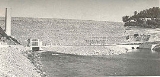
The dam has two intakes, one at the north end and one at the south end. The north intake transfers water from the reservoir via high-pressure conduit to the powerhouse at the northern base of the dam. The south intake feeds water into the dam's spillway, from which it travels through a sluiceway to a stilling basin at the southern base of the dam.
on the river's Watauga River
tributary, no major projects had been initiated. In the 1920s, the Holston River Power Company conducted a massive survey of the South Fork Holston's watershed with plans to build four dams on the river, including one at the present South Holston Dam site. After the Tennessee Valley Authority gained oversight of the Tennessee River watershed in the following decade, it proposed the construction of two dams in the South Fork Holston basin— one at the South Holston Dam site and the other at Cardens Bluff (modern Watauga Dam
). The primary purpose for building these two dams was flood control, especially in light of a disastrous flood in 1940 that had destroyed several structures in Bluff City
and Kingsport
, both downstream from the proposed dam sites. The dams would also produce electricity to help TVA meet the high demand for power at the outbreak of World War II
. South Holston Dam and its sister project, Watauga Dam, were authorized on December 17, 1941, and work began on February 16 of the following year.
 The construction of South Holston Dam and its reservoir required the purchase of 12860 acres (52 km²) of land, 3875 acres (16 km²) of which had to be cleared. 342 families, 559 graves, and 30.5 miles (49.1 km) of roads had to be relocated, and four new bridges were built. In October 1942, the U.S. War Production Board
ordered a halt to the South Holston and Watauga projects, claiming they were not vital to the nation's war effort. TVA spent several weeks securing the dam sites, and the South Holston project was stalled until the end of the war. Work on South Holston began again on August 4, 1947, as Watauga neared completion.
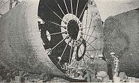
Along with the main dam, the South Holston project required the construction of a saddle dam approximately 4 miles (6.4 km) north of the main dam at the reservoir's Painter Spring embayment. The saddle dam is 40 feet (12.2 m) high and 3400 feet (1,036.3 m) long. The project also necessitated the construction of an auxiliary spillway, since the main dam's morning glory spillway had not been adequately tested. This auxiliary spillway— known as the "Bent Branch Spillway" after the stream into which it empties— is located about 1.5 miles (2.4 km) south of the main dam.
South Holston Dam was completed and its gates closed November 20, 1950. The dam's generator went online February 13, 1951. The total cost of the South Holston project was just over $31 million.
Tennessee
Tennessee is a U.S. state located in the Southeastern United States. It has a population of 6,346,105, making it the nation's 17th-largest state by population, and covers , making it the 36th-largest by total land area...
. It is the uppermost of three dams on the South Fork Holston owned and operated by the Tennessee Valley Authority
Tennessee Valley Authority
The Tennessee Valley Authority is a federally owned corporation in the United States created by congressional charter in May 1933 to provide navigation, flood control, electricity generation, fertilizer manufacturing, and economic development in the Tennessee Valley, a region particularly affected...
, which built the dam in the 1940s as part of efforts to control flooding in the Tennessee River
Tennessee River
The Tennessee River is the largest tributary of the Ohio River. It is approximately 652 miles long and is located in the southeastern United States in the Tennessee Valley. The river was once popularly known as the Cherokee River, among other names...
watershed. The dam impounds the South Holston Lake
South Holston Lake
South Holston Lake is located near the cities of Abingdon, Virginia and Bristol, Virginia / Bristol, Tennessee, and is a impoundment operated by the Tennessee Valley Authority . Much of the reservoir is in Tennessee, but the Virginia portion of the reservoir offers anglers more than of water...
of 7550 acres (31 km²), which extends northeastward across the Tennessee-Virginia
Virginia
The Commonwealth of Virginia , is a U.S. state on the Atlantic Coast of the Southern United States. Virginia is nicknamed the "Old Dominion" and sometimes the "Mother of Presidents" after the eight U.S. presidents born there...
state line.
Location
South Holston Dam is located 50 miles (80.5 km) above the South Fork Holston River's confluence with the North Fork Holston River (which forms the Holston RiverHolston River
The Holston River is a major river system of southwestern Virginia and east Tennessee. The three major forks of the Holston rise in southwestern Virginia and have their confluence near Kingsport, Tennessee. The North Fork flows southwest from Sharon Springs in Bland County, Virginia...
proper). The dam site is situated in an area where the river descends out of the Appalachian Mountains
Appalachian Mountains
The Appalachian Mountains #Whether the stressed vowel is or ,#Whether the "ch" is pronounced as a fricative or an affricate , and#Whether the final vowel is the monophthong or the diphthong .), often called the Appalachians, are a system of mountains in eastern North America. The Appalachians...
and enters the upper Holston Valley. The dam and the Tennessee half of its reservoir are surrounded by the Cherokee National Forest
Cherokee National Forest
The Cherokee National Forest is a large National Forest created on July 19, 1936, by U.S. President Franklin Roosevelt, operated by the U.S. Forest Service and encompassing some 640,000 acres .-Location:...
, and the Virginia half of the reservoir is surrounded by the Jefferson National Forest. The reservoir includes parts of Sullivan County in Tennessee and Washington County
Washington County, Virginia
As of the census of 2000, there were 51,103 people, 21,056 households, and 14,949 families residing in the county. The population density was 91 people per square mile . There were 22,985 housing units at an average density of 41 per square mile...
in Virginia. The city of Bristol
Bristol, Tennessee
Bristol is a city in Sullivan County, Tennessee, United States. The population was 26,702 at the 2010 census. It is the twin city of Bristol, Virginia, which lies directly across the state line between Tennessee and Virginia. The boundaries of both cities run parallel to each other along State...
straddles the Tennessee-Virginia border a few miles northwest of South Holston Dam.
Capacity
South Holston Dam is an earth-and-rock dam 285 feet (86.9 m) high and 1600 feet (487.7 m) long, and has a generating capacity of 38,500 kilowatts. The dam's fixed-crest morning glory spillway has a maximum discharge of 116200 cuft/s. South Holston Lake extends northeastward for 24 miles (38.6 km) into southwestern Virginia, and has 168 miles (270.4 km) of shoreline and a flood storage capacity of 252757 acre.ft. The reservoir's operating levels vary by about 23 feet (7 m) in a typical year.The dam has two intakes, one at the north end and one at the south end. The north intake transfers water from the reservoir via high-pressure conduit to the powerhouse at the northern base of the dam. The south intake feeds water into the dam's spillway, from which it travels through a sluiceway to a stilling basin at the southern base of the dam.
Background and construction
Various private entities had investigated the South Fork Holston's hydroelectric potential since the early 1900s, although other than Wilbur DamWilbur Dam
Wilbur Dam is a hydroelectric dam on the Watauga River in Carter County, in the U.S. state of Tennessee. It is one of two dams on the river owned and operated by the Tennessee Valley Authority. The dam impounds Wilbur Lake, which extends for about up the Watauga to the base of Watauga Dam...
on the river's Watauga River
Watauga River
The Watauga River is a large stream of western North Carolina and East Tennessee. It is 60 miles long with its headwaters on the slopes of Grandfather Mountain and Peak Mountain in Watauga County, North Carolina.-Hydrography:...
tributary, no major projects had been initiated. In the 1920s, the Holston River Power Company conducted a massive survey of the South Fork Holston's watershed with plans to build four dams on the river, including one at the present South Holston Dam site. After the Tennessee Valley Authority gained oversight of the Tennessee River watershed in the following decade, it proposed the construction of two dams in the South Fork Holston basin— one at the South Holston Dam site and the other at Cardens Bluff (modern Watauga Dam
Watauga Dam
Watauga Dam is a hydroelectric and flood control dam on the Watauga River in Carter County, in the U.S. state of Tennessee. It is owned and operated by the Tennessee Valley Authority, which built the dam in the 1940s as part of efforts to control flooding in the Tennessee River watershed...
). The primary purpose for building these two dams was flood control, especially in light of a disastrous flood in 1940 that had destroyed several structures in Bluff City
Bluff City, Tennessee
Bluff City is a city in Sullivan County, Tennessee, United States. The population was 1,733 at the 2010 census. It is part of the Kingsport–Bristol –Bristol Metropolitan Statistical Area, which is a component of the Johnson City–Kingsport–Bristol, TN-VA Combined Statistical...
and Kingsport
Kingsport, Tennessee
Kingsport is a city located mainly in Sullivan County with some western portions in Hawkins County in the US state of Tennessee. The majority of the city lies in Sullivan County...
, both downstream from the proposed dam sites. The dams would also produce electricity to help TVA meet the high demand for power at the outbreak of World War II
World War II
World War II, or the Second World War , was a global conflict lasting from 1939 to 1945, involving most of the world's nations—including all of the great powers—eventually forming two opposing military alliances: the Allies and the Axis...
. South Holston Dam and its sister project, Watauga Dam, were authorized on December 17, 1941, and work began on February 16 of the following year.
War Production Board
The War Production Board was established as a government agency on January 16, 1942 by executive order of Franklin D. Roosevelt.The purpose of the board was to regulate the production and allocation of materials and fuel during World War II in the United States...
ordered a halt to the South Holston and Watauga projects, claiming they were not vital to the nation's war effort. TVA spent several weeks securing the dam sites, and the South Holston project was stalled until the end of the war. Work on South Holston began again on August 4, 1947, as Watauga neared completion.
Along with the main dam, the South Holston project required the construction of a saddle dam approximately 4 miles (6.4 km) north of the main dam at the reservoir's Painter Spring embayment. The saddle dam is 40 feet (12.2 m) high and 3400 feet (1,036.3 m) long. The project also necessitated the construction of an auxiliary spillway, since the main dam's morning glory spillway had not been adequately tested. This auxiliary spillway— known as the "Bent Branch Spillway" after the stream into which it empties— is located about 1.5 miles (2.4 km) south of the main dam.
South Holston Dam was completed and its gates closed November 20, 1950. The dam's generator went online February 13, 1951. The total cost of the South Holston project was just over $31 million.
External links
- South Holston Reservoir — official TVA site