

South Bay, Boston, Massachusetts
Encyclopedia
- For the actual bayBayA bay is an area of water mostly surrounded by land. Bays generally have calmer waters than the surrounding sea, due to the surrounding land blocking some waves and often reducing winds. Bays also exist as an inlet in a lake or pond. A large bay may be called a gulf, a sea, a sound, or a bight...
, see South Bay (Boston).
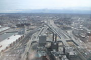
South Bay is a 10-acre (40,000 m²) site in Boston, Massachusetts
Massachusetts
The Commonwealth of Massachusetts is a state in the New England region of the northeastern United States of America. It is bordered by Rhode Island and Connecticut to the south, New York to the west, and Vermont and New Hampshire to the north; at its east lies the Atlantic Ocean. As of the 2010...
sandwiched between Chinatown
Chinatown
A Chinatown is an ethnic enclave of overseas Chinese people, although it is often generalized to include various Southeast Asian people. Chinatowns exist throughout the world, including East Asia, Southeast Asia, the Americas, Australasia, and Europe. Binondo's Chinatown located in Manila,...
and the Leather District. It is roughly bounded by Kneeland Street, Hudson Street, the Massachusetts Turnpike
Massachusetts Turnpike
The Massachusetts Turnpike is the easternmost stretch of Interstate 90. The Turnpike begins at the western border of Massachusetts in West Stockbridge connecting with the Berkshire Connector portion of the New York State Thruway...
mainline, and the Interstate 93
Interstate 93
Interstate 93 is an Interstate Highway in the New England section of the United States. Its southern terminus is in Canton, Massachusetts, in the Boston metropolitan area, at Interstate 95; its northern terminus is near St. Johnsbury, Vermont, at Interstate 91...
mainline. Currently owned by the Massachusetts Turnpike Authority (MTA), the site is being put up for development. The developer with the winning bid could put up an office tower as high as 600 feet, but the site is being envisioned as a mixed-use project anchored by office towers, that would include parkland, retail, hotel, and residential space. The South Bay development will serve as the southern anchor of the Rose Kennedy Greenway
Rose Kennedy Greenway
The Rose Kennedy Greenway is a roughly 1.5-mile-long long series of parks and public spaces being created in downtown Boston, Massachusetts, USA. It is the final part of the Big Dig that put Interstate 93 underground and removed the elevated freeway that served as the main highway through downtown...
, a stretch of parks, museums, and civic spaces that will replace the Central Artery
Central Artery
The John F. Fitzgerald Expressway, known locally as the Central Artery, is a section of freeway in downtown Boston, Massachusetts, designated as Interstate 93, U.S. Route 1 and Route 3. It was initially constructed in the 1950s as a partly elevated and partly tunneled divided highway...
.
Currently, the site is partly occupied by basketball courts, temporary highway ramps for the Central Artery, and the old Wang Building, the headquarters for the Big Dig. Most of this will be demolished to make way for the new development.
In terms of scale and scope, if current plans prevail, this development will be the largest in the Boston area since the construction of the Prudential Tower
Prudential Tower
The Prudential Tower, also known as the Prudential Building or, colloquially, The Pru, is a skyscraper in Boston, Massachusetts. The building, a part of the Prudential Center complex, currently stands as the 2nd-tallest building in Boston, behind the John Hancock Tower. The Prudential Tower was...
in 1964. It is hoped that the project will integrate into the surrounding street grid.
History of the site
The South Bay district, as well as the adjacent ChinatownChinatown, Boston
The only historically Chinese area in New England, Chinatown, Boston is a neighborhood located in downtown Boston, Massachusetts. Centered on Beach Street, the neighborhood borders Boston Common, Downtown Crossing, the South End, and the Southeast Expressway/Massachusetts Turnpike.Part of it...
and Leather District
Leather District, Boston, Massachusetts
The Leather District is a neighborhood of Boston near South Street, between the Financial District and Chinatown. The Leather District is a tightly defined area bounded by Kneeland Street to the south, Essex Street to the north, Atlantic Avenue to the east and Lincoln Street to the west...
neighborhoods, sit on filled land. Once part of South Cove
South Cove
-Asia:*South Cove, India's southernmost point in the Arabian Sea branch of the Indian Ocean....
, a portion of Boston's South Bay, it was filled in 1833 by the South Cove Corporation, who built an intermodal train/sea station as part of the Boston and Worcester Railroad. This development included residential and commercial area, and what was considered at the time to be the largest hotel in the United States. Throughout most of the 19th Century and the early half of the 20th Century, the district was made up of rail yard
Rail yard
A rail yard, or railroad yard, is a complex series of railroad tracks for storing, sorting, or loading/unloading, railroad cars and/or locomotives. Railroad yards have many tracks in parallel for keeping rolling stock stored off the mainline, so that they do not obstruct the flow of traffic....
s serving railroads entering Boston from the south and west.
The rail yards and terminus attracted leather and garment businesses, which constructed the commercial buildings in the adjacent Leather District. Similarly, the railroad served as an immigrant gateway, a role which it played beginning in the late 19th century for many Asian newcomers, particularly Chinese.
In the 1950s, the Massachusetts Highway Department displaced much of the rail yards to build the John F. Fitzgerald Expressway (the Central Artery). Later the South Bay interchange connected the Central Artery to the Massachusetts Turnpike. The intersection has been reconstructed by the Big Dig. Most of the highway has been buried, leaving these parcels available for development.