
South-East Busway, Brisbane
Encyclopedia
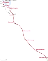
The South East Busway is a grade separated
bus-only corridor running south from the Brisbane
CBD
to Eight Mile Plains
, in South East Queensland
. Service providers using the Busway operate under the TransLink
system. The Busway was completed to Woolloongabba in September 2000 and to Eight Mile Plains in April 2001.
Busways would allow buses to service low-density communities and bypass peak hour congestion. Busway stations could be developed at key nodes to service major activity centres and combining different routes would create high frequency services.
In 1995, plans for a network of five busway corridors were conceived, linking with the rail network to improve public transport connectivity across the city. The busways would improve the operation of the bus fleet, reducing maintenance and running costs and maximizing the effectiveness of the region's investment in buses.
In August 1996, the Queensland Government approved the South East Transit Project to manage the construction of both the northern section of the Pacific Motorway between Mount Gravatt and Logan City and a dedicated 2-lane, 2-way road for buses between Brisbane CBD and Eight Mile Plains.
The first section of busway between the CBD and Woolloongabba was opened to services on 13 September 2000 to coincide with the first match in the 2000 Olympic Games Football Tournament in Brisbane. The second section of busway (13.2 km) between Woolloongabba and Eight Mile Plains opened on 30 April 2001.
(M1). The northern end crosses the Victoria Bridge
and enters the CBD to connect with the Queen Street bus station and Adelaide Street bus mall.
enable better connections between the South East Busway, Springwood and Loganholme
with additional stations in between at Underwood and Paradise Road, for the benefit of Logan City Bus Service passengers travelling to the city.
As part of the Main Roads Pacific Motorway Transit Project, plans have been made to extend the South-East Busway as far as Springwood bus station including construction of the proposed Rochedale busway station.
system.
Grade separation
Grade separation is the method of aligning a junction of two or more transport axes at different heights so that they will not disrupt the traffic flow on other transit routes when they cross each other. The composition of such transport axes does not have to be uniform; it can consist of a...
bus-only corridor running south from the Brisbane
Brisbane
Brisbane is the capital and most populous city in the Australian state of Queensland and the third most populous city in Australia. Brisbane's metropolitan area has a population of over 2 million, and the South East Queensland urban conurbation, centred around Brisbane, encompasses a population of...
CBD
Central business district
A central business district is the commercial and often geographic heart of a city. In North America this part of a city is commonly referred to as "downtown" or "city center"...
to Eight Mile Plains
Eight Mile Plains, Queensland
Eight Mile Plains is a southern suburb of Brisbane, Queensland, Australia. It is located some 13 kilometres from the Brisbane central business district....
, in South East Queensland
South East Queensland
South East Queensland is a region of the state of Queensland in Australia, which contains approximately two-thirds of the state population...
. Service providers using the Busway operate under the TransLink
TransLink (South East Queensland)
The TransLink Transit Authority is the authority introduced by the Queensland Government in June 2003 as a section of Queensland Transport to coordinate and integrate rail, bus and ferry services. TransLink works with Airtrain, Brisbane Transport, Brisbane Ferries, QR Citytrain and 17 other...
system. The Busway was completed to Woolloongabba in September 2000 and to Eight Mile Plains in April 2001.
History
Busways were considered as one of the options when the Queensland Government developed the 25 year Integrated Regional Transport Plan. Other methods such as light and heavy rail were also considered. It was recommended that a 75 km network of busway corridors to complement the existing heavy rail network would suit best.Busways would allow buses to service low-density communities and bypass peak hour congestion. Busway stations could be developed at key nodes to service major activity centres and combining different routes would create high frequency services.
In 1995, plans for a network of five busway corridors were conceived, linking with the rail network to improve public transport connectivity across the city. The busways would improve the operation of the bus fleet, reducing maintenance and running costs and maximizing the effectiveness of the region's investment in buses.
In August 1996, the Queensland Government approved the South East Transit Project to manage the construction of both the northern section of the Pacific Motorway between Mount Gravatt and Logan City and a dedicated 2-lane, 2-way road for buses between Brisbane CBD and Eight Mile Plains.
The first section of busway between the CBD and Woolloongabba was opened to services on 13 September 2000 to coincide with the first match in the 2000 Olympic Games Football Tournament in Brisbane. The second section of busway (13.2 km) between Woolloongabba and Eight Mile Plains opened on 30 April 2001.
Route
The Busway is connected at its southern end to Springwood bus station by transit lanes on the Pacific MotorwayPacific Motorway
The Pacific Motorway is a 100 km long motorway in Australia between Brisbane, Queensland, and the New South Wales-Queensland border at Tweed Heads. The motorway starts at Coronation Drive at Milton in Brisbane, and from 2008 links the Tweed Heads bypass in New South Wales...
(M1). The northern end crosses the Victoria Bridge
Victoria Bridge, Brisbane
The Victoria Bridge is a vehicular and pedestrian bridge over the Brisbane River. The current bridge, opened in 1969, is the third permanent crossing erected at this location...
and enters the CBD to connect with the Queen Street bus station and Adelaide Street bus mall.
Future Extensions
Currently, transit lanes on the Pacific MotorwayPacific Motorway
The Pacific Motorway is a 100 km long motorway in Australia between Brisbane, Queensland, and the New South Wales-Queensland border at Tweed Heads. The motorway starts at Coronation Drive at Milton in Brisbane, and from 2008 links the Tweed Heads bypass in New South Wales...
enable better connections between the South East Busway, Springwood and Loganholme
Loganholme, Queensland
Loganholme is a suburb of Logan City, Queensland, Australia. A major landmark in the area is the Logan Hyperdome shopping centre. A bus interchange is located adjacent to the Logan Hyperdome. The area is also home to the Loganholme State School....
with additional stations in between at Underwood and Paradise Road, for the benefit of Logan City Bus Service passengers travelling to the city.
As part of the Main Roads Pacific Motorway Transit Project, plans have been made to extend the South-East Busway as far as Springwood bus station including construction of the proposed Rochedale busway station.
Passenger Information
Real Time Passenger Information is displayed at each station, with fixed LED signs suspended above each platform. These signs present four lines of real-time estimated bus departure times, with data provided by Brisbane City Council's RAPIDBCC-RAPID
Brisbane City Council - Realtime Advanced Priority and Information Delivery is abus priority and passenger information system developed by Brisbane City Council that is in use on the South-East and Inner-Northern busways and will be implemented on the Northern and Eastern Brisbane busways when...
system.