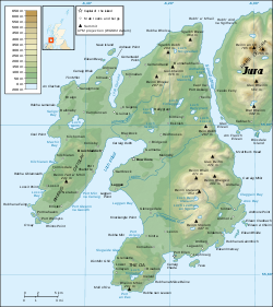
Sound of Islay
Encyclopedia

Strait
A strait or straits is a narrow, typically navigable channel of water that connects two larger, navigable bodies of water. It most commonly refers to a channel of water that lies between two land masses, but it may also refer to a navigable channel through a body of water that is otherwise not...
between the islands of Islay
Islay
-Prehistory:The earliest settlers on Islay were nomadic hunter-gatherers who arrived during the Mesolithic period after the retreat of the Pleistocene ice caps. In 1993 a flint arrowhead was found in a field near Bridgend dating from 10,800 BC, the earliest evidence of a human presence found so far...
and Jura
Jura, Scotland
Jura is an island in the Inner Hebrides of Scotland, situated adjacent and to the north-east of Islay. Part of the island is designated as a National Scenic Area. Until the twentieth century Jura was dominated - and most of it was eventually owned - by the Campbell clan of Inveraray Castle on Loch...
off the west coast of Scotland. It is approximately 30 kilometres (18.6 mi) in extent from north to south and lies between Rubh' a' Mhàil on Islay and Rubh' Aird na Sgitheich on Jura to the north and Macarthur's Head and Rubha na Tràille to the south. The islands in the Sound are Am Fraoch Eilean, Brosdale Island and Glas Eilean, all of which are off the south east coast of Jura. These islands, Jura south of Loch Tarbert and the eastern part of the Sound are one of 40 National Scenic Area
National Scenic Area
National Scenic Area is a designation for areas of natural beauty used by more than one nation.* National Scenic Area * National Scenic Area * National scenic areas in Taiwan* National Scenic Area...
s in Scotland.
History
Am Fraoch Eilean (meaning "heather isle"Eilean Fraoch
This is a list of islands called Eilean Fraoch or Fraoch Eilean, which provides an index for islands in Scotland with this and similar names. Literally meaning "heather island" in Scottish Gaelic, it is a common Scottish island name....
) contains the ruins of the medieval stronghold Claig Castle. It was built by Somerled
Somerled
Somerled was a military and political leader of the Scottish Isles in the 12th century who was known in Gaelic as rí Innse Gall . His father was Gillebride...
in 1154 to defend the Sound and later used as a prison. Unusually for the Argyll
Argyll
Argyll , archaically Argyle , is a region of western Scotland corresponding with most of the part of ancient Dál Riata that was located on the island of Great Britain, and in a historical context can be used to mean the entire western coast between the Mull of Kintyre and Cape Wrath...
islands the design, which is a Norman square tower with 3 metres (9.8 ft) thick walls, is similar in style to mainland castles of the period.
In 1549 Dean Monro
Donald Monro (Dean)
Donald Monro was a Scottish clergyman, who wrote an early and historically valuable description of the Hebrides and other Scottish islands and enjoyed the honorific title of “Dean of the Isles”.-Origins:...
wrote: "At the mouth of Kyle Ila, betwixt it and Duray, lyes ane ile, callit in Erische Leid Ellan Charne, in English the iyle of Earne". This may refer to Eilean a' Chùirn at .
Ferry
Argyll and Bute Council operate a vehicle and passenger ferry service across the Sound from FeolinFeolin
Feolin is a slipway on the west coast of Jura. It provides the only regular access to the island, with a vehicle and passenger ferry service from Port Askaig on Islay across the Sound of Islay. The road on both islands has the designation A846....
slipway
Ferry slip
A ferry slip is a specialized docking facility that receives a ferryboat or train ferry. A similar structure called a barge slip receives a barge or car float that is used to carry wheeled vehicles across a body of water....
on the west coast of Jura to Port Askaig
Port Askaig
Port Askaig is a port village on the east coast of the island of Islay, in Scotland.-Transport:Port Askaig serves as the main port of Islay, sharing passenger services to the Scottish mainland with Port Ellen...
on Islay, and Caledonian Macbrayne operate a vehicle and passenger ferry between Port Askaig and Kennacraig, on the mainland in West Loch Tarbert.
Renewable energy
In March 2011 the largest tidal arrayTidal power
Tidal power, also called tidal energy, is a form of hydropower that converts the energy of tides into useful forms of power - mainly electricity....
in the world was approved by the Scottish Government for the Sound of Islay, with 10 planned tidal turbines predicted to generate enough power for over 5,000 homes. The site offers both high currents and shelter from storms.

