
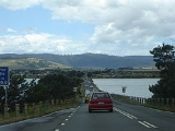
Sorell Causeway
Encyclopedia
The Sorell Causeway is a causeway
that stretches from the western side of Midway Point across Orielton Lagoon
to Sorell
. Together with Mcgees Bridge
(that connects the eastern side of Midway Point
) they connect Sorell with Hobart via the Tasman Highway
.
In colonial times, the Richmond Bridge
had been the primary crossing point of the Coal River on the road from Hobart
to Sorell
and beyond to the Tasman Peninsula
and Port Arthur
.
It had been decided much earlier that if a crossing at Pitt Water could be made, it would considerably reduce the time to reach Sorell. The engineering was difficult, but with a ready supply of convict labour on hand, the causeway was constructed with main force. It was finally completed in 1872.
The Sorell Causeway is the second such convict-built causeway in the South-East of Tasmania, and is similar to the causeway section of the Bridgewater Bridge across the Derwent River
.
In recent years it has undergone massive repairs and modifications. It has been decided that there needed to be a better flow of tidal water from Pitt Water and Orielton Lagoon into the open sea as the stagnation was causing outbreaks of Blue-Green Algae which was poisoning the other marine species there. As a result sluice conduits were cut into the lagoon, and a new pile system was created, to turn longer sections of the causeway into actual bridges.
Ever since its construction it has been a major route of access from Hobart to the east coast and the Tasman Peninsula
, and is now a section of the Tasman Highway
.
Causeway
In modern usage, a causeway is a road or railway elevated, usually across a broad body of water or wetland.- Etymology :When first used, the word appeared in a form such as “causey way” making clear its derivation from the earlier form “causey”. This word seems to have come from the same source by...
that stretches from the western side of Midway Point across Orielton Lagoon
Orielton Lagoon
Orielton Lagoon is a shallow Lagoon located west of Sorell in Tasmania, Australia.-Description:The lagoon is 1.3 metres deep , and is approximately 2.65 square kilometres in area, separated from Pitt Water by the Sorell Causeway. It is a Ramsar Wetland, providing habitat for migratory shorebirds...
to Sorell
Sorell, Tasmania
Sorell is a town in Tasmania, Australia, north-east of Hobart. It is on the Tasman Highway which continues up the east coast of Tasmania. At the 2006 census, Sorell had a population of 1,546....
. Together with Mcgees Bridge
Mcgees Bridge
Mcgees Bridge and causeway crosses Pitt Water within the greater area of Hobart, Tasmania.The bridge provides a vital link between Hobart and two of Tasmania's principal tourist attractions - Port Arthur Historic Site on the Tasman Peninsula and the picturesque East Coast via the Tasman...
(that connects the eastern side of Midway Point
Midway Point, Tasmania
Midway Point is an outlying suburb of Hobart, capital of Tasmania, Australia. It is in the local government area of Sorell Council, and is located on a small peninsula with Orielton Lagoon on its eastern side and Pitt Water on its southern and western sides...
) they connect Sorell with Hobart via the Tasman Highway
Tasman Highway
The Tasman Highway is a highway in Tasmania, Australia. Like the Midland Highway, it connects the major cities of Hobart and Launceston — however it takes a different route, via the north-eastern and eastern coasts of the state. The Highway also acts as a major commuter road to Hobart...
.
In colonial times, the Richmond Bridge
Richmond Bridge, Tasmania
The Richmond Bridge is a heritage listed arch bridge located on the B31 in Richmond, 25 kilometres north of Hobart in Tasmania, Australia. It is the oldest bridge still in use in Australia.-History:...
had been the primary crossing point of the Coal River on the road from Hobart
Hobart
Hobart is the state capital and most populous city of the Australian island state of Tasmania. Founded in 1804 as a penal colony,Hobart is Australia's second oldest capital city after Sydney. In 2009, the city had a greater area population of approximately 212,019. A resident of Hobart is known as...
to Sorell
Sorell, Tasmania
Sorell is a town in Tasmania, Australia, north-east of Hobart. It is on the Tasman Highway which continues up the east coast of Tasmania. At the 2006 census, Sorell had a population of 1,546....
and beyond to the Tasman Peninsula
Tasman Peninsula
Tasman Peninsula is located around by road south-east of Hobart, at the south east corner of Tasmania, Australia.-Description:The Tasman Peninsula lies south and west of Forestier Peninsula, to which it is connected by an isthmus called Eaglehawk Neck...
and Port Arthur
Port Arthur, Tasmania
Port Arthur is a small town and former convict settlement on the Tasman Peninsula, in Tasmania, Australia. Port Arthur is one of Australia's most significant heritage areas and the open air museum is officially Tasmania's top tourist attraction. It is located approximately 60 km south east of...
.
It had been decided much earlier that if a crossing at Pitt Water could be made, it would considerably reduce the time to reach Sorell. The engineering was difficult, but with a ready supply of convict labour on hand, the causeway was constructed with main force. It was finally completed in 1872.
The Sorell Causeway is the second such convict-built causeway in the South-East of Tasmania, and is similar to the causeway section of the Bridgewater Bridge across the Derwent River
Derwent River (Tasmania)
The Derwent is a river in Tasmania, Australia. It was named after the River Derwent, Cumbria by British Commodore John Hayes who explored it in 1793. The name is Brythonic Celtic for "valley thick with oaks"....
.
In recent years it has undergone massive repairs and modifications. It has been decided that there needed to be a better flow of tidal water from Pitt Water and Orielton Lagoon into the open sea as the stagnation was causing outbreaks of Blue-Green Algae which was poisoning the other marine species there. As a result sluice conduits were cut into the lagoon, and a new pile system was created, to turn longer sections of the causeway into actual bridges.
Ever since its construction it has been a major route of access from Hobart to the east coast and the Tasman Peninsula
Tasman Peninsula
Tasman Peninsula is located around by road south-east of Hobart, at the south east corner of Tasmania, Australia.-Description:The Tasman Peninsula lies south and west of Forestier Peninsula, to which it is connected by an isthmus called Eaglehawk Neck...
, and is now a section of the Tasman Highway
Tasman Highway
The Tasman Highway is a highway in Tasmania, Australia. Like the Midland Highway, it connects the major cities of Hobart and Launceston — however it takes a different route, via the north-eastern and eastern coasts of the state. The Highway also acts as a major commuter road to Hobart...
.