Snowdon Massif
Encyclopedia
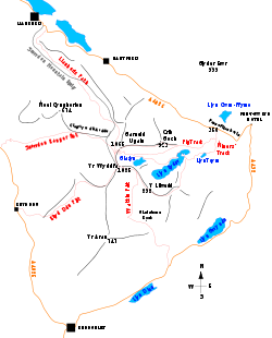
Snowdonia
Snowdonia is a region in north Wales and a national park of in area. It was the first to be designated of the three National Parks in Wales, in 1951.-Name and extent:...
, north Wales
Wales
Wales is a country that is part of the United Kingdom and the island of Great Britain, bordered by England to its east and the Atlantic Ocean and Irish Sea to its west. It has a population of three million, and a total area of 20,779 km²...
, to include mountains over 3,000 feet (914 m
Metre
The metre , symbol m, is the base unit of length in the International System of Units . Originally intended to be one ten-millionth of the distance from the Earth's equator to the North Pole , its definition has been periodically refined to reflect growing knowledge of metrology...
) high. It occupies the area between Beddgelert
Beddgelert
Beddgelert, or in older English spelling often Bedgellert, is a village and community in the Snowdonia area of Gwynedd, Wales. It is reputed to be named after the legendary hound Gelert. Population 617.- History:...
, Pen-y-Pass
Pen-y-Pass
Pen-y-Pass is a mountain pass in Snowdonia, Gwynedd, north-west Wales. It is a popular location from which to walk up Snowdon, as three of the popular routes can be started here...
and Llanberis
Llanberis
Llanberis is a village in Gwynedd, North Wales, lying on the southern banks of Llyn Padarn in Snowdonia. It takes its name from Saint Peris, an early Welsh saint.According to the United Kingdom Census 2001, the population of Llanberis was 1,954...
. It is surrounded by the Glyderau
Glyderau
The Glyderau are a mountain group in Snowdonia, North Wales. The name derives from the highest peaks in the range, Glyder Fawr and Glyder Fach....
to the north-east, Moel Siabod
Moel Siabod
Moel Siabod is a mountain in Snowdonia, North Wales, which sits isolated above the villages of Betws-y-Coed and Capel Curig. At 872m it is the highest peak in the Moelwynion mountain range. The UK National Mountain Centre, Plas-y-Brenin, is located at the foot of Moel Siabod...
to the east, the Moelwynion
Moelwynion
The Moelwynion are a group of mountains in central Snowdonia. They extend from the north-east of Porthmadog to Moel Siabod, the highest of the group...
to the south, Moel Hebog
Moel Hebog
Moel Hebog is a mountain in Snowdonia, north Wales which dominates the view west from the village of Beddgelert...
, the Nantlle Ridge
Nantlle Ridge
The Nantlle Ridge is the name given to a small range of mountains in Snowdonia, north Wales which runs south-west from the village of Rhyd Ddu for a distance of about , ending above Talysarn and Nebo in the Nantlle Valley....
and Mynydd Mawr
Mynydd Mawr
Mynydd Mawr is a mountain in Snowdonia, North Wales, situated approximately west of Snowdon itself, overlooking Llyn Cwellyn and being the northern outlier of the Moel Hebog group. A popular ascent starts from Rhyd Ddu. On its western flank are the remains of ancient settlements and field systems...
to the west, and by flatter land leading down to Caernarfon
Caernarfon
Caernarfon is a Royal town, community and port in Gwynedd, Wales, with a population of 9,611. It lies along the A487 road, on the east banks of the Menai Straits, opposite the Isle of Anglesey. The city of Bangor is to the northeast, while Snowdonia fringes Caernarfon to the east and southeast...
and the Menai Strait
Menai Strait
The Menai Strait is a narrow stretch of shallow tidal water about long, which separates the island of Anglesey from the mainland of Wales.The strait is bridged in two places - the main A5 road is carried over the strait by Thomas Telford's elegant iron suspension bridge, the first of its kind,...
to the north-west.
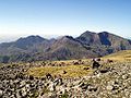
The Snowdon Horseshoe is the name given to the semi-circular ring of ridges and peaks on Snowdon's eastern side, i.e. facing down Dyffryn Mymbyr
Dyffryn Mymbyr
Dyffryn Mymbyr is a valley in Snowdonia, North Wales, approximately in length, and leading up from Capel Curig to the Pen-y-Gwryd hotel....
towards Capel Curig
Capel Curig
Capel Curig is a village and community in Conwy County Borough, in Wales. It lies in the heart of Snowdonia, on the River Llugwy, and has a population of 226...
. The peaks in the Horseshoe are those of Y Lliwedd
Y Lliwedd
Y Lliwedd is a mountain, connected to Yr Wyddfa in the Snowdonia National Park, North Wales.Its summit lies 2,946 ft above sea level....
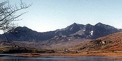
, Snowdon
Snowdon
Snowdon is the highest mountain in Wales, at an altitude of above sea level, and the highest point in the British Isles outside Scotland. It is located in Snowdonia National Park in Gwynedd, and has been described as "probably the busiest mountain in Britain"...
, Garnedd Ugain
Garnedd Ugain
Garnedd Ugain, sometimes incorrectly referred to as "Crib y Ddysgl", is a mountain in Wales that forms part of the Snowdon Horseshoe. It is the second highest peak in Wales, and lies 1 kilometre north of Snowdon...
and Crib Goch
Crib Goch
Crib Goch is described as a "knife-edged" arête in the Snowdonia National Park in Gwynedd, Wales. The name means red comb in the Welsh language, presumably referring to the serrated ridge and the colour of some of the rocks....
.
Peaks
All the peaks listed here are Hewitts; those marked with an asterisk are also MarilynsMarilyn (hill)
A Marilyn is a mountain or hill in the United Kingdom, Republic of Ireland or Isle of Man with a relative height of at least 150 metres , regardless of absolute height or other merit...
.
- SnowdonSnowdonSnowdon is the highest mountain in Wales, at an altitude of above sea level, and the highest point in the British Isles outside Scotland. It is located in Snowdonia National Park in Gwynedd, and has been described as "probably the busiest mountain in Britain"...
, also called Yr Wyddfa * - 1,085 m - Garnedd UgainGarnedd UgainGarnedd Ugain, sometimes incorrectly referred to as "Crib y Ddysgl", is a mountain in Wales that forms part of the Snowdon Horseshoe. It is the second highest peak in Wales, and lies 1 kilometre north of Snowdon...
, also called Crib y Ddysgl - 1,065 m - Crib GochCrib GochCrib Goch is described as a "knife-edged" arête in the Snowdonia National Park in Gwynedd, Wales. The name means red comb in the Welsh language, presumably referring to the serrated ridge and the colour of some of the rocks....
- 923 m - Y LliweddY LliweddY Lliwedd is a mountain, connected to Yr Wyddfa in the Snowdonia National Park, North Wales.Its summit lies 2,946 ft above sea level....
* - 898 m - Yr AranYr AranYr Aran is a mountain peak on a ridge radiating south from Snowdon, Wales' highest mountain, with beautiful views of the summit of Snowdon, Moel Hebog and the Nantlle Ridge....
* - 747 m - Moel EilioMoel EilioMoel Eilio is a mountain in Snowdonia, North Wales, that is situated approximately 3 miles north-west of Snowdon itself. It has two subsidiary tops, Foel Gron and Foel Goch . The average annual temperature of the mountain is around 6 degrees celsius...
- 726 m - Moel CynghorionMoel CynghorionMoel Cynghorion is a mountain in Snowdonia, North Wales. It lies several miles north-west of Snowdon, and forms part of the Moel Eilio Horseshoe walk. The summit is situated on a wide plateau, marked by a pile of stones. The southern slopes are gentle, while the northern aspect is precipitous. The...
* - 674 m - Foel GronFoel GronFoel Gron is a peak on the Moel Eilio ridge of hills/mountains in Snowdonia, North Wales. This ridge is used as a hiker's route from Llanberis to the summit of Snowdon.-External links:*...
- 629 m