
Antarctic Place-names Commission
Encyclopedia


Bulgarian Antarctic Institute
Bulgarian Antarctic Institute is the national Antarctic operator of Bulgaria, organizing annual Antarctic campaigns and maintaining the Bulgarian Antarctic base of St. Kliment Ohridski on Livingston Island in the South Shetland Islands...
in 1994, and since 2001 has been a body affiliated to the Ministry of Foreign Affairs
Ministry of Foreign Affairs (Bulgaria)
The Ministry of Foreign Affairs of Bulgaria is the ministry charged with overseeing the foreign relations of Bulgaria. It has been in existence since shortly after the Liberation of Bulgaria, with the first minister stepping into office on 17 July 1879...
of Bulgaria
Bulgaria
Bulgaria , officially the Republic of Bulgaria , is a parliamentary democracy within a unitary constitutional republic in Southeast Europe. The country borders Romania to the north, Serbia and Macedonia to the west, Greece and Turkey to the south, as well as the Black Sea to the east...
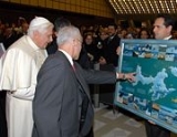
. The Commission approves Bulgarian place names in Antarctica, which are formally given by the President of the Republic according to the Bulgarian Constitution
Constitution of Bulgaria
The Constitution of Bulgaria is the supreme and basic law of the Republic of Bulgaria. The current constitution was adopted on 12 July 1991 by the 7th Grand National Assembly of Bulgaria, and defines the country as a unitary parliamentary republic...
(Art. 98) and the established international practice.
Bulgarian names in Antarctica
Geographical names in Antarctica reflect the history and practice of Antarctic exploration. The nations involved in Antarctic research give new names to nameless geographical features for the purposes of orientation, logistics, and international scientific cooperation. As of 2008, there are some 18,500 named Antarctic geographical features, including 398 features with names given by Bulgaria. Since the Bulgarian Antarctic baseSt. Kliment Ohridski Base
St. Kliment Ohridski Base is a Bulgarian Antarctic base on Livingston Island in the South Shetland Islands.The base, originally known as Sofia University Refuge, was named in 1993 "for St...
is situated in the South Shetland Islands
South Shetland Islands
The South Shetland Islands are a group of Antarctic islands, lying about north of the Antarctic Peninsula, with a total area of . By the Antarctic Treaty of 1959, the Islands' sovereignty is neither recognized nor disputed by the signatories and they are free for use by any signatory for...
, most of the Bulgarian place names are concentrated in that area too, especially on Livingston Island, Greenwich Island
Greenwich Island (South Shetland Islands)
Greenwich Island is an island long and from wide, lying between Robert Island and Livingston Island in the South Shetland Islands. Surface area...
, Robert Island
Robert Island (South Shetland Islands)
Robert Island or Mitchells Island or Polotsk Island or Roberts Island is an island long and wide, situated between Nelson Island and Greenwich Island in the South Shetland Islands. Robert Island is located at . Surface area...
, Snow Island
Snow Island (South Shetland Islands)
Snow Island or Isla Nevada is a completely ice-covered island, in size, lying southwest of Livingston Island in the South Shetland Islands. Surface area...
, and Smith Island
Smith Island (South Shetland Islands)
Smith Island is long and wide, lying west of Deception Island in the South Shetland Islands of the British Antarctic Territory. Surface area ....
. However, two early Bulgarian names were given even in 1989 (by the then State Council, a collegial presidency) to geographical features on Alexander Island
Alexander Island
Alexander Island or Alexander I Island or Alexander I Land or Alexander Land is the largest island of Antarctica, with an area of lying in the Bellingshausen Sea west of the base of the Antarctic Peninsula, from which it is separated by Marguerite Bay and George VI Sound. Alexander Island lies off...
in relation to field work carried out on that island by the first Bulgarian Antarctic expedition during the 1987/88 season.
Toponymic guidelines
In 1995 the Commission developed its own Toponymic Guidelines defining the relevant types of geographical features, specific elements of geographical names, inappropriate names, criteria of names approval, language and spelling, and names approval procedures. In particular, the Guidelines introduced the Streamlined System that was subsequently adopted as the official national system for the Romanization of BulgarianRomanization of Bulgarian
Romanization of Bulgarian is the practice of transliteration of text in the Bulgarian language from its conventional Cyrillic orthography into the Latin alphabet. Romanization can be used for various purposes, such as rendering of proper names and place names in foreign-language contexts, or for...
, eventually becoming part of Bulgarian law by way of the 2009 Transliteration Law.
Surveys and mapping
The work of the Commission is supported by geographical informationGeographic Information System
A geographic information system, geographical information science, or geospatial information studies is a system designed to capture, store, manipulate, analyze, manage, and present all types of geographically referenced data...
and mapping
Cartography
Cartography is the study and practice of making maps. Combining science, aesthetics, and technique, cartography builds on the premise that reality can be modeled in ways that communicate spatial information effectively.The fundamental problems of traditional cartography are to:*Set the map's...
resulting from topographic
Topography
Topography is the study of Earth's surface shape and features or those ofplanets, moons, and asteroids...
surveys
Surveying
See Also: Public Land Survey SystemSurveying or land surveying is the technique, profession, and science of accurately determining the terrestrial or three-dimensional position of points and the distances and angles between them...
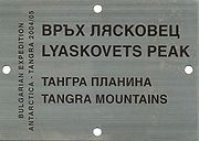
in Antarctica, such as the 1995/96 survey in Livingston Island, and the topographic survey Tangra 2004/05
Tangra 2004/05
The Tangra 2004/05 Expedition was commissioned by the Antarctic Place-names Commission at the Ministry of Foreign Affairs of Bulgaria, managed by the Manfred Wörner Foundation, and supported by the Bulgarian Antarctic Institute, the Institute of Mathematics and Informatics at the Bulgarian Academy...
. The Commission published the first Bulgarian topographic map of Livingston Island and Greenwich Island in 2005, and jointly with the Military Topographic Service of the Bulgarian Army, the first detailed topographic map of Smith Island
Smith Island (South Shetland Islands)
Smith Island is long and wide, lying west of Deception Island in the South Shetland Islands of the British Antarctic Territory. Surface area ....
in 2008.
International cooperation
The Antarctic Place-names Commission cooperates with other national authorities for Antarctic place names, and with the Scientific Committee on Antarctic Research (SCAR)Scientific Committee on Antarctic Research
The Scientific Committee on Antarctic Research is an interdisciplinary body of the International Council for Science . It was established in February 1958 to continue the international coordination of Antarctic scientific activities that had begun during the International Geophysical Year of 1957-58...
. Details of the Bulgarian Antarctic toponyms
Toponymy
Toponymy is the scientific study of place names , their origins, meanings, use and typology. The word "toponymy" is derived from the Greek words tópos and ónoma . Toponymy is itself a branch of onomastics, the study of names of all kinds...
are published by the Commission’s website, and also by the international Composite Gazetteer of Antarctica
Composite Gazetteer of Antarctica
The Composite Gazetteer of Antarctica of the Scientific Committee on Antarctic Research is the authoritative international gazetteer containing all the Antarctic toponyms published in national gazetteers, plus basic information about those names and the relevant geographical features...
maintained by SCAR.
Antarctic names in Bulgaria
In order to promote Antarctic exploration and the presence of Bulgaria in Antarctica, the Commission encourages Bulgarian municipalities to give relevant Antarctic names to public places. Several squares and streets in Bulgarian settlements are named after Livingston Island, such as Livingston Island Square in SamuilSamuil (village)
Samuil is a village in northeastern Bulgaria, part of Razgrad Province, located in the geographic region of Ludogorie. It is the administrative centre of the homonymous Samuil Municipality, which lies in the southeastern part of the Province...
and Kula
Kula, Bulgaria
Kula is a town in northwestern Bulgaria. It is the administrative centre of Kula Municipality part of Vidin Province. Located just east of the Serbian-Bulgarian border, it is the third largest town in the province after Vidin and Belogradchik. Kula lies 30 kilometres west of Vidin and 13...
, and Livingston Island Street in Gotse Delchev
Gotse Delchev (town)
Gotse Delchev , is a town in Blagoevgrad Province of Bulgaria with a population of 23,573.In 1951 the town was renamed after the Bulgarian revolutionary Georgi Nikolov Delchev. It had hitherto been called Nevrokop ....
, Yambol
Yambol
Yambol is a city in southeastern Bulgaria, an administrative centre of Yambol Province. It lies on both banks of the Tundzha river in the historical region of Thrace. As of February 2011, the town has a population of 72,843 inhabitants. It is occasionally spelt 'Jambol'.The administrative centres...
, Petrich
Petrich
Petrich is a town in Blagoevgrad Province in southwestern Bulgaria, located at the foot of the Belasica Mountains in the Strumeshnitsa Valley. , the town has 29920 inhabitants.Petrich is located close to the borders with Greece and the Republic of Macedonia...
, Sofia
Sofia
Sofia is the capital and largest city of Bulgaria and the 12th largest city in the European Union with a population of 1.27 million people. It is located in western Bulgaria, at the foot of Mount Vitosha and approximately at the centre of the Balkan Peninsula.Prehistoric settlements were excavated...
, Lovech
Lovech
Lovech is a town in north-central Bulgaria with a population of 36,296 as of February 2011. It is the administrative centre of the Lovech Province and of the subordinate Lovech Municipality. The town is located about 150 km northeast from the capital city of Sofia...
and Vidin
Vidin
Vidin is a port town on the southern bank of the Danube in northwestern Bulgaria. It is close to the borders with Serbia and Romania, and is also the administrative centre of Vidin Province, as well as of the Metropolitan of Vidin...
.
See also
- SCAR Composite Gazetteer of AntarcticaComposite Gazetteer of AntarcticaThe Composite Gazetteer of Antarctica of the Scientific Committee on Antarctic Research is the authoritative international gazetteer containing all the Antarctic toponyms published in national gazetteers, plus basic information about those names and the relevant geographical features...
- Bulgarian toponyms in Antarctica
- St. Kliment Ohridski BaseSt. Kliment Ohridski BaseSt. Kliment Ohridski Base is a Bulgarian Antarctic base on Livingston Island in the South Shetland Islands.The base, originally known as Sofia University Refuge, was named in 1993 "for St...
- Camp AcademiaCamp AcademiaCamp Academia is a geographical locality in eastern Livingston Island, South Shetland Islands, Antarctica, named for the Bulgarian Academy of Sciences in appreciation of Academy’s contribution to the Antarctic exploration...
- Tangra 2004/05Tangra 2004/05The Tangra 2004/05 Expedition was commissioned by the Antarctic Place-names Commission at the Ministry of Foreign Affairs of Bulgaria, managed by the Manfred Wörner Foundation, and supported by the Bulgarian Antarctic Institute, the Institute of Mathematics and Informatics at the Bulgarian Academy...
- Alexander IslandAlexander IslandAlexander Island or Alexander I Island or Alexander I Land or Alexander Land is the largest island of Antarctica, with an area of lying in the Bellingshausen Sea west of the base of the Antarctic Peninsula, from which it is separated by Marguerite Bay and George VI Sound. Alexander Island lies off...
- Livingston Island
- Greenwich Island
- Robert IslandRobert Island (South Shetland Islands)Robert Island or Mitchells Island or Polotsk Island or Roberts Island is an island long and wide, situated between Nelson Island and Greenwich Island in the South Shetland Islands. Robert Island is located at . Surface area...
- Snow IslandSnow Island (South Shetland Islands)Snow Island or Isla Nevada is a completely ice-covered island, in size, lying southwest of Livingston Island in the South Shetland Islands. Surface area...
- Smith IslandSmith Island (South Shetland Islands)Smith Island is long and wide, lying west of Deception Island in the South Shetland Islands of the British Antarctic Territory. Surface area ....
- South Shetland IslandsSouth Shetland IslandsThe South Shetland Islands are a group of Antarctic islands, lying about north of the Antarctic Peninsula, with a total area of . By the Antarctic Treaty of 1959, the Islands' sovereignty is neither recognized nor disputed by the signatories and they are free for use by any signatory for...
- Antarctica
Maps
- L.L. Ivanov. St. Kliment Ohridski Base, Livingston Island. Scale 1:1000 topographic map. Sofia: Antarctic Place-names Commission of Bulgaria, 1996. (The first Bulgarian Antarctic topographic map, in Bulgarian and English)
- L.L. Ivanov. Livingston Island: Central-Eastern Region. Scale 1:25000 topographic map. Sofia: Antarctic Place-names Commission of Bulgaria, 1996.
- L.L. Ivanov et al. Antarctica: Livingston Island and Greenwich Island, South Shetland Islands (from English Strait to Morton Strait, with illustrations and ice-cover distribution). Scale 1:100000 topographic map. Sofia: Antarctic Place-names Commission of Bulgaria, 2005.
- L.L. Ivanov. Antarctica: Livingston Island and Greenwich, Robert, Snow and Smith Islands. Scale 1:120000 topographic map. Troyan: Manfred Wörner Foundation, 2009. (in Bulgarian) ISBN 978-954-92032-4-0 (Updated second edition 2010. ISBN 978-954-92032-8-8)
- L.L. Ivanov. Antarctica: Livingston Island and Greenwich, Robert, Snow and Smith Islands. Scale 1:120000 topographic map. Troyan: Manfred Wörner Foundation, 2009. ISBN 978-954-92032-6-4 (Updated second edition 2010. ISBN 978-954-92032-9-5)
External links
- Antarctic Place-names Commission of Bulgaria (History; Toponymic Guidelines; Surveys; Antarctic Maps; Bulgarian Antarctic Gazetteer)
- Composite Gazetteer of Antarctica