

Simonsbath
Encyclopedia
Simonsbath is a village high on Exmoor
in the English
county of Somerset
. It is the principal settlement in the Exmoor civil parish, which is the largest and most sparsely populated civil parish
on Exmoor, covering nearly 32 mi2 but with a population, at the time of the 2001 census
, of 203 in 78 households.
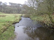
The River Exe
rises from a valley to the north, and the River Barle
runs through the village, and is crossed by a triple-arched medieval bridge which was extensively repaired after floods in 1952. It is also on the Two Moors Way
footpath.
, in his View of Devonshire in 1630, preserved a local tradition that "Simon" was a great hunter and Robin Hood-like figure who had his stronghold at Symonsburrow, at the highest point of the Blackdown Hills
, a barrow that pre-dates even a medieval legend associated with it.
In 2005 the term ‘Inn’ was reinstated to the name, when the building was renovated.
When known as the William Rufus Inn, it was said to be the haunt of the noted Exmoor Highwayman Tom Faggus, who married ‘Girt Jan Ridds’ sister whose exploits are recorded in ‘Lorna Doone’. Once it was said, Faggus’s enemies laid a trap to catch him in the Inn, but Faggus whistled for his strawberry mare Winnie who jumped through the window and kicked all her masters enemies away from him. Faggus jumped on the mares back and escaped.
was built in the mid-seventeenth century for John Boevey, the warden of the Royal forest
of Exmoor
and for 150 years his was the only house in the forest which consists largely of moorland
. After the Royal Act of Inclosure it was bought, with the accompanying farm and about 70000 acres (283.3 km²), the remaining portion of the former Royal Forest belonging to the Crown
, by John Knight of Worcestershire in 1818 for the sum of £50,000. The Grade II listed building is now the Simonsbath House Hotel, and outdoor activity centre. Knight set about converting the Royal Forest, now known as Exmoor National Park, into agricultural land. He and especially his son Frederick, who assumed management in 1841, erected most of the large farms in the central section of the moor and built 22 miles (35.4 km) of metalled access roads to Simonsbath. He built a 29 miles (47 km) wall around his estate, much of which still survives.
developed in the nineteenth century, when more houses were built along with St Luke's Church (1856), providing a centre for the population. The church has been designated by English Heritage
as a Grade II listed building. At around the same time as the construction of the church a mine was developed alongside the River Barle. The mine was originally called Wheal Maria, then changed to Wheal Eliza. It was a copper mine from 1845–54 and then an iron mine until 1857, although the first mining activity on the site may be from 1552. A restored Victorian
water-powered sawmill in the village, which was damaged in the floods of 1992, has now been purchased by the National Park and returned to working order, making the footpath signs, gates, stiles, and bridges for various sites in the National Park.
. Sir John William Fortescue, the fifth son of the third earl, was librarian at Windsor Castle
1905–26 and was best known for his sixteen-volume History of the British Army. After his death in 1933 his ashes were scattered locally and a cairn built in his memory. The eldest sons of the Earls Fortescue had the courtesy title of Lord Ebrington. The last Lord Ebrington died in World War II
at El Alamein
.
groups on matters of crime, security, and traffic. The parish council's role also includes initiating projects for the maintenance and repair of parish facilities, as well as consulting with the district council on the maintenance, repair, and improvement of highways, drainage, footpaths, public transport, and street cleaning. Conservation matters (including trees and listed buildings) and environmental issues are also the responsibility of the council.
The village falls within the Non-metropolitan district
of West Somerset
, which was formed on April 1, 1974 under the Local Government Act 1972
, having previously been part of Dulverton Rural District
. The district council are responsible for local planning
and building control, local roads, council housing, environmental health
, market
s and fairs, refuse collection and recycling
, cemeteries and crematoria, leisure services, parks, and tourism
.
Somerset County Council
are responsible for running the largest and most expensive local services such as education
, social services, libraries
, main roads, public transport
, policing
and fire services, trading standards
, waste disposal and strategic planning. Local health services are managed by the Somerset Coast Primary Care Trust.
It is also part of the Bridgwater and West Somerset constituency represented in the House of Commons
of the Parliament of the United Kingdom
. It elects one Member of Parliament (MP)
by the first past the post system of election, and part of the South West England constituency
of the European Parliament
which elects seven MEPs using the d'Hondt method
of party-list proportional representation
.
 Simonsbath is 1250 feet (381 m) above sea level, in the valley of the River Barle
. On the Chains
is a 3 acres (1.2 ha) reservoir known as Pinkery Pond. It was formed by damming the River Barle, in the 19th century by John Knight and his son, and was originally intended to be 7 acres (2.8 ha). The purpose is unknown but close to the pond is the remains of a small canal.
On the moor north of the village is Exe Head, which is the source of the River Exe
. It lies on peaty soils over rocks dating from the mid Devonian
(to which this area gave its name) to early Carboniferous
periods. Quartz
and iron
mineralisation can be detected in outcrops and subsoil. The Devonian Kentisbury Slates are exposed in the small quarry by white water.
The mean annual temperature is 8.3 °C (47 °F). The average annual total rainfall is 69.6 inches (1,768 mm), although 7.35 inches (187 mm) fell in the 24-hour period preceding 10 a.m. on 16 August 1952, which was one of the contributory factors leading to the flooding in Lynmouth
.
Exmoor
Exmoor is an area of hilly open moorland in west Somerset and north Devon in South West England, named after the main river that flows out of the district, the River Exe. The moor has given its name to a National Park, which includes the Brendon Hills, the East Lyn Valley, the Vale of Porlock and ...
in the English
England
England is a country that is part of the United Kingdom. It shares land borders with Scotland to the north and Wales to the west; the Irish Sea is to the north west, the Celtic Sea to the south west, with the North Sea to the east and the English Channel to the south separating it from continental...
county of Somerset
Somerset
The ceremonial and non-metropolitan county of Somerset in South West England borders Bristol and Gloucestershire to the north, Wiltshire to the east, Dorset to the south-east, and Devon to the south-west. It is partly bounded to the north and west by the Bristol Channel and the estuary of the...
. It is the principal settlement in the Exmoor civil parish, which is the largest and most sparsely populated civil parish
Civil parish
In England, a civil parish is a territorial designation and, where they are found, the lowest tier of local government below districts and counties...
on Exmoor, covering nearly 32 mi2 but with a population, at the time of the 2001 census
United Kingdom Census 2001
A nationwide census, known as Census 2001, was conducted in the United Kingdom on Sunday, 29 April 2001. This was the 20th UK Census and recorded a resident population of 58,789,194....
, of 203 in 78 households.
The River Exe
River Exe
The River Exe in England rises near the village of Simonsbath, on Exmoor in Somerset, near the Bristol Channel coast, but flows more or less directly due south, so that most of its length lies in Devon. It reaches the sea at a substantial ria, the Exe Estuary, on the south coast of Devon...
rises from a valley to the north, and the River Barle
River Barle
The River Barle runs from the Chains on northern Exmoor, in Somerset, England to join the River Exe at Exebridge, Devon. The river and the Barle Valley are both designated as biological Site of Special Scientific Interest....
runs through the village, and is crossed by a triple-arched medieval bridge which was extensively repaired after floods in 1952. It is also on the Two Moors Way
Two Moors Way
The Two Moors Way is a long-distance path that runs from Ivybridge in South Devon to Lynmouth on the coast of North Devon, crossing parts of both Dartmoor and Exmoor along the way...
footpath.
The name
The -bath element in this place-name, not recorded before 1791, is easily accounted for: the Old English bæth signified "water, a pool". The identity of Simon is less sure. R.J. King pointed out that the name is frequently met with in the West of England, "especially in connection with old boundary lines". Thomas WestcoteThomas Westcote
-Life:Baptised at Shobrooke in Devon on 17 June 1567, he was the third son of Philip Westcote of West Raddon in the parish of Shobrooke, by his wife Katharine, daughter of George Waltham of Brenton in the parish of Exminster, Devon...
, in his View of Devonshire in 1630, preserved a local tradition that "Simon" was a great hunter and Robin Hood-like figure who had his stronghold at Symonsburrow, at the highest point of the Blackdown Hills
Blackdown Hills
The Blackdown Hills are a range of hills along the Somerset-Devon border in south-western England, which were designated an Area of Outstanding Natural Beauty in 1991....
, a barrow that pre-dates even a medieval legend associated with it.
The Exmoor Forest Inn
The Exmoor Forest Inn was originally known as the Refreshment House, then from 1885 The William Rufus Inn and then The Exmoor Forest Hotel in 1901. For a while it was split in half with the nearest part to the road being the Temperance Hotel, until re-united in 1909. It was teetotal until 1933 when the parish of Exmoor was granted its excise licence.In 2005 the term ‘Inn’ was reinstated to the name, when the building was renovated.
When known as the William Rufus Inn, it was said to be the haunt of the noted Exmoor Highwayman Tom Faggus, who married ‘Girt Jan Ridds’ sister whose exploits are recorded in ‘Lorna Doone’. Once it was said, Faggus’s enemies laid a trap to catch him in the Inn, but Faggus whistled for his strawberry mare Winnie who jumped through the window and kicked all her masters enemies away from him. Faggus jumped on the mares back and escaped.
Simonsbath House
Simonsbath HouseSimonsbath House
Simonsbath House is a historic house in Simonsbath on Exmoor in Somerset, England. The Grade II listed building is now the Simonsbath House Hotel, and outdoor activity centre...
was built in the mid-seventeenth century for John Boevey, the warden of the Royal forest
Royal forest
A royal forest is an area of land with different meanings in England, Wales and Scotland; the term forest does not mean forest as it is understood today, as an area of densely wooded land...
of Exmoor
Exmoor
Exmoor is an area of hilly open moorland in west Somerset and north Devon in South West England, named after the main river that flows out of the district, the River Exe. The moor has given its name to a National Park, which includes the Brendon Hills, the East Lyn Valley, the Vale of Porlock and ...
and for 150 years his was the only house in the forest which consists largely of moorland
Moorland
Moorland or moor is a type of habitat, in the temperate grasslands, savannas, and shrublands biome, found in upland areas, characterised by low-growing vegetation on acidic soils and heavy fog...
. After the Royal Act of Inclosure it was bought, with the accompanying farm and about 70000 acres (283.3 km²), the remaining portion of the former Royal Forest belonging to the Crown
Crown Estate
In the United Kingdom, the Crown Estate is a property portfolio owned by the Crown. Although still belonging to the monarch and inherent with the accession of the throne, it is no longer the private property of the reigning monarch and cannot be sold by him/her, nor do the revenues from it belong...
, by John Knight of Worcestershire in 1818 for the sum of £50,000. The Grade II listed building is now the Simonsbath House Hotel, and outdoor activity centre. Knight set about converting the Royal Forest, now known as Exmoor National Park, into agricultural land. He and especially his son Frederick, who assumed management in 1841, erected most of the large farms in the central section of the moor and built 22 miles (35.4 km) of metalled access roads to Simonsbath. He built a 29 miles (47 km) wall around his estate, much of which still survives.
The mansion was never finished; cultivation has not spread far from the farmstead centres; the walls bother the sportsman more than the deer; and the bogs are as deep, the inner recesses of the moors as wild and solitary, and the coarse grass, and the bracken, and the heathers supreme in their occupancy mile after mile, as if no effort had ever been made to redeem its mingled wildness and sterility."
19th-century expansion
The small hamletHamlet (place)
A hamlet is usually a rural settlement which is too small to be considered a village, though sometimes the word is used for a different sort of community. Historically, when a hamlet became large enough to justify building a church, it was then classified as a village...
developed in the nineteenth century, when more houses were built along with St Luke's Church (1856), providing a centre for the population. The church has been designated by English Heritage
English Heritage
English Heritage . is an executive non-departmental public body of the British Government sponsored by the Department for Culture, Media and Sport...
as a Grade II listed building. At around the same time as the construction of the church a mine was developed alongside the River Barle. The mine was originally called Wheal Maria, then changed to Wheal Eliza. It was a copper mine from 1845–54 and then an iron mine until 1857, although the first mining activity on the site may be from 1552. A restored Victorian
Victorian era
The Victorian era of British history was the period of Queen Victoria's reign from 20 June 1837 until her death on 22 January 1901. It was a long period of peace, prosperity, refined sensibilities and national self-confidence...
water-powered sawmill in the village, which was damaged in the floods of 1992, has now been purchased by the National Park and returned to working order, making the footpath signs, gates, stiles, and bridges for various sites in the National Park.
20th century
Simonsbath was owned by the Earls FortescueEarl Fortescue
Earl Fortescue is a title in the Peerage of Great Britain created in 1789. The Fortescue family descends from Sir Hugh Fortescue of Filleigh, Devon, who died in 1719. His first wife's first cousin had been 13th Baron Clinton and 5th Earl of Lincoln...
. Sir John William Fortescue, the fifth son of the third earl, was librarian at Windsor Castle
Windsor Castle
Windsor Castle is a medieval castle and royal residence in Windsor in the English county of Berkshire, notable for its long association with the British royal family and its architecture. The original castle was built after the Norman invasion by William the Conqueror. Since the time of Henry I it...
1905–26 and was best known for his sixteen-volume History of the British Army. After his death in 1933 his ashes were scattered locally and a cairn built in his memory. The eldest sons of the Earls Fortescue had the courtesy title of Lord Ebrington. The last Lord Ebrington died in World War II
World War II
World War II, or the Second World War , was a global conflict lasting from 1939 to 1945, involving most of the world's nations—including all of the great powers—eventually forming two opposing military alliances: the Allies and the Axis...
at El Alamein
El Alamein
El Alamein is a town in the northern Matrouh Governorate of Egypt. Located on the Mediterranean Sea, it lies west of Alexandria and northwest of Cairo. As of 2007, it has a local population of 7,397 inhabitants.- Climate :...
.
Governance
The civil parish of Exmoor has its own parish council which has responsibility for local issues, including setting an annual precept (local rate) to cover the council’s operating costs and producing annual accounts for public scrutiny. The parish council evaluates local planning applications and works with the local police, district council officers, and neighbourhood watchNeighbourhood Watch (UK)
The Neighbourhood Watch scheme in the United Kingdom is a partnership where people come together to make their communities safer. It involves the Police, Community Safety departments of local authorities, other voluntary organisations and, above all, individuals and families who want to make their...
groups on matters of crime, security, and traffic. The parish council's role also includes initiating projects for the maintenance and repair of parish facilities, as well as consulting with the district council on the maintenance, repair, and improvement of highways, drainage, footpaths, public transport, and street cleaning. Conservation matters (including trees and listed buildings) and environmental issues are also the responsibility of the council.
The village falls within the Non-metropolitan district
Non-metropolitan district
Non-metropolitan districts, or colloquially shire districts, are a type of local government district in England. As created, they are sub-divisions of non-metropolitan counties in a so-called "two-tier" arrangement...
of West Somerset
West Somerset
West Somerset is a local government district in the English county of Somerset. The council covers a largely rural area, with a population of 35,075 in an area of ....
, which was formed on April 1, 1974 under the Local Government Act 1972
Local Government Act 1972
The Local Government Act 1972 is an Act of Parliament in the United Kingdom that reformed local government in England and Wales on 1 April 1974....
, having previously been part of Dulverton Rural District
Dulverton Rural District
Dulverton was a rural district in Somerset, England, from 1894 to 1974.It was created in 1894 under the Local Government Act 1894.In 1974 it was abolished under the Local Government Act 1972 and responsibilities transferred to West Somerset....
. The district council are responsible for local planning
Planning permission
Planning permission or planning consent is the permission required in the United Kingdom in order to be allowed to build on land, or change the use of land or buildings. Within the UK the occupier of any land or building will need title to that land or building , but will also need "planning...
and building control, local roads, council housing, environmental health
Environmental health
Environmental health is the branch of public health that is concerned with all aspects of the natural and built environment that may affect human health...
, market
Market
A market is one of many varieties of systems, institutions, procedures, social relations and infrastructures whereby parties engage in exchange. While parties may exchange goods and services by barter, most markets rely on sellers offering their goods or services in exchange for money from buyers...
s and fairs, refuse collection and recycling
Recycling
Recycling is processing used materials into new products to prevent waste of potentially useful materials, reduce the consumption of fresh raw materials, reduce energy usage, reduce air pollution and water pollution by reducing the need for "conventional" waste disposal, and lower greenhouse...
, cemeteries and crematoria, leisure services, parks, and tourism
Tourism
Tourism is travel for recreational, leisure or business purposes. The World Tourism Organization defines tourists as people "traveling to and staying in places outside their usual environment for not more than one consecutive year for leisure, business and other purposes".Tourism has become a...
.
Somerset County Council
Somerset County Council
Somerset County Council is the county council of Somerset in the South West of England, an elected local government authority responsible for the most significant local government services in most of the county.-Area covered:...
are responsible for running the largest and most expensive local services such as education
Local Education Authority
A local education authority is a local authority in England and Wales that has responsibility for education within its jurisdiction...
, social services, libraries
Library
In a traditional sense, a library is a large collection of books, and can refer to the place in which the collection is housed. Today, the term can refer to any collection, including digital sources, resources, and services...
, main roads, public transport
Public transport
Public transport is a shared passenger transportation service which is available for use by the general public, as distinct from modes such as taxicab, car pooling or hired buses which are not shared by strangers without private arrangement.Public transport modes include buses, trolleybuses, trams...
, policing
Police
The police is a personification of the state designated to put in practice the enforced law, protect property and reduce civil disorder in civilian matters. Their powers include the legitimized use of force...
and fire services, trading standards
Trading Standards
Trading Standards is the name given to local authority departments in the UK formerly known as Weights and Measures. These departments investigate commercial organisations that carry out trade in unethical ways or outside the scope of the law.-History:...
, waste disposal and strategic planning. Local health services are managed by the Somerset Coast Primary Care Trust.
It is also part of the Bridgwater and West Somerset constituency represented in the House of Commons
British House of Commons
The House of Commons is the lower house of the Parliament of the United Kingdom, which also comprises the Sovereign and the House of Lords . Both Commons and Lords meet in the Palace of Westminster. The Commons is a democratically elected body, consisting of 650 members , who are known as Members...
of the Parliament of the United Kingdom
Parliament of the United Kingdom
The Parliament of the United Kingdom of Great Britain and Northern Ireland is the supreme legislative body in the United Kingdom, British Crown dependencies and British overseas territories, located in London...
. It elects one Member of Parliament (MP)
Member of Parliament
A Member of Parliament is a representative of the voters to a :parliament. In many countries with bicameral parliaments, the term applies specifically to members of the lower house, as upper houses often have a different title, such as senate, and thus also have different titles for its members,...
by the first past the post system of election, and part of the South West England constituency
South West England (European Parliament constituency)
South West England is a constituency of the European Parliament. For 2009 it elects 6 MEPs using the d'Hondt method of party-list proportional representation, reduced from 7 in 2004.-Boundaries:...
of the European Parliament
European Parliament
The European Parliament is the directly elected parliamentary institution of the European Union . Together with the Council of the European Union and the Commission, it exercises the legislative function of the EU and it has been described as one of the most powerful legislatures in the world...
which elects seven MEPs using the d'Hondt method
D'Hondt method
The d'Hondt method is a highest averages method for allocating seats in party-list proportional representation. The method described is named after Belgian mathematician Victor D'Hondt who described it in 1878...
of party-list proportional representation
Party-list proportional representation
Party-list proportional representation systems are a family of voting systems emphasizing proportional representation in elections in which multiple candidates are elected...
.
Geography
River Barle
The River Barle runs from the Chains on northern Exmoor, in Somerset, England to join the River Exe at Exebridge, Devon. The river and the Barle Valley are both designated as biological Site of Special Scientific Interest....
. On the Chains
Chains (geological site)
The Chains is the name given to the north-west plateau of Exmoor, Somerset, England. This plateau lies above the contour line, and includes the source of the River Barle....
is a 3 acres (1.2 ha) reservoir known as Pinkery Pond. It was formed by damming the River Barle, in the 19th century by John Knight and his son, and was originally intended to be 7 acres (2.8 ha). The purpose is unknown but close to the pond is the remains of a small canal.
On the moor north of the village is Exe Head, which is the source of the River Exe
River Exe
The River Exe in England rises near the village of Simonsbath, on Exmoor in Somerset, near the Bristol Channel coast, but flows more or less directly due south, so that most of its length lies in Devon. It reaches the sea at a substantial ria, the Exe Estuary, on the south coast of Devon...
. It lies on peaty soils over rocks dating from the mid Devonian
Devonian
The Devonian is a geologic period and system of the Paleozoic Era spanning from the end of the Silurian Period, about 416.0 ± 2.8 Mya , to the beginning of the Carboniferous Period, about 359.2 ± 2.5 Mya...
(to which this area gave its name) to early Carboniferous
Carboniferous
The Carboniferous is a geologic period and system that extends from the end of the Devonian Period, about 359.2 ± 2.5 Mya , to the beginning of the Permian Period, about 299.0 ± 0.8 Mya . The name is derived from the Latin word for coal, carbo. Carboniferous means "coal-bearing"...
periods. Quartz
Quartz
Quartz is the second-most-abundant mineral in the Earth's continental crust, after feldspar. It is made up of a continuous framework of SiO4 silicon–oxygen tetrahedra, with each oxygen being shared between two tetrahedra, giving an overall formula SiO2. There are many different varieties of quartz,...
and iron
Iron
Iron is a chemical element with the symbol Fe and atomic number 26. It is a metal in the first transition series. It is the most common element forming the planet Earth as a whole, forming much of Earth's outer and inner core. It is the fourth most common element in the Earth's crust...
mineralisation can be detected in outcrops and subsoil. The Devonian Kentisbury Slates are exposed in the small quarry by white water.
The mean annual temperature is 8.3 °C (47 °F). The average annual total rainfall is 69.6 inches (1,768 mm), although 7.35 inches (187 mm) fell in the 24-hour period preceding 10 a.m. on 16 August 1952, which was one of the contributory factors leading to the flooding in Lynmouth
Lynmouth
Lynmouth is a village in Devon, England, on the north edge of Exmoor.The village straddles the confluence of the West Lyn and East Lyn rivers, in a gorge below Lynton, to which it is connected by the Lynton and Lynmouth Cliff Railway....
.