
Sierra Vista Scenic Byway
Encyclopedia
The Sierra Vista Scenic Byway is an 82.7 miles (133.1 km) route through the Sierra National Forest
in the U.S. state of California
. Many examples of the Sierra’s most distinctive granite domes, meadows and glacial valleys can be seen along the way. The Sierra Vista Scenic Byway begins two miles (3 km) north of the foothill community of North Fork
, climbing the western slope of the Sierra Nevada mountain range until its crest, and finally dropping back down into the foothills near Oakhurst
.
. The designation continues west on FS 7; the initial part of it is a dirt road. FS 7 eventually becomes paved again; however, the byway continues southwest onto Sky Ranch Road, which is FS 10 and is initially unpaved. The byway ends at SR 41.
The route is generally open June through October and takes approximately 5 hours to drive.
as seen by the many acorn grinding mortars in the surrounding granite. Theodore Roosevelt
was once photographed here.
is a large granite dome
that rises from the forest above Soquel Meadow. It is the last designated landmark on the route.
Sierra National Forest
Sierra National Forest is a U.S. National Forest located on the western slope of central Sierra Nevada in the state of California. The forest is known for its mountain scenery and natural resources. Forest headquarters are located in Clovis, California...
in the U.S. state of California
California
California is a state located on the West Coast of the United States. It is by far the most populous U.S. state, and the third-largest by land area...
. Many examples of the Sierra’s most distinctive granite domes, meadows and glacial valleys can be seen along the way. The Sierra Vista Scenic Byway begins two miles (3 km) north of the foothill community of North Fork
North Fork, California
North Fork is an unincorporated community in Madera County, California. It is located east of Raymond, at an elevation of 2638 feet .It is miles south east of Bass Lake and from Oakhurst. North Fork is also home of the Mono Indian Museum and the starting point of the Sierra scenic byway...
, climbing the western slope of the Sierra Nevada mountain range until its crest, and finally dropping back down into the foothills near Oakhurst
Oakhurst, California
Oakhurst is a census-designated place in Madera County, California, south of the entrance to Yosemite National Park, in the foothills of the Sierra Nevada mountain range. Oakhurst is located on the Fresno River south-southwest of Yosemite Forks, at an elevation of 2274 feet...
.
Route description
The byway begins on Forest Service Road 81 (FS 81) and continues north, loosely paralleling the San Joaquin RiverSan Joaquin River
The San Joaquin River is the largest river of Central California in the United States. At over long, the river starts in the high Sierra Nevada, and flows through a rich agricultural region known as the San Joaquin Valley before reaching Suisun Bay, San Francisco Bay, and the Pacific Ocean...
. The designation continues west on FS 7; the initial part of it is a dirt road. FS 7 eventually becomes paved again; however, the byway continues southwest onto Sky Ranch Road, which is FS 10 and is initially unpaved. The byway ends at SR 41.
The route is generally open June through October and takes approximately 5 hours to drive.
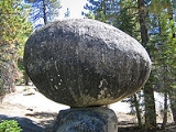
Globe Rock
Globe Rock, a large granite sphere resting atop a small granite perch, is an unusual geological feature. It once served as a gathering place of the Mono IndiansMono tribe
The Mono are a Native American people who traditionally live in the central Sierra Nevada Mountains, the Eastern Sierra , the Mono Basin, and adjacent areas of the Great Basin.-Culture and geography:...
as seen by the many acorn grinding mortars in the surrounding granite. Theodore Roosevelt
Theodore Roosevelt
Theodore "Teddy" Roosevelt was the 26th President of the United States . He is noted for his exuberant personality, range of interests and achievements, and his leadership of the Progressive Movement, as well as his "cowboy" persona and robust masculinity...
was once photographed here.
Fresno Dome
Fresno DomeFresno Dome
Fresno Dome is a dominant granite dome rising in isolation above the forest of Soquel Meadow in the Sierra National Forest in Madera County, California....
is a large granite dome
Granite dome
A granite dome is a dome of granite, formed by exfoliation.-Formation:Granite forms plutons of igneous rock several kilometers below the surface as magma slowly cools and crystallizes. The granite is under great overhead pressure....
that rises from the forest above Soquel Meadow. It is the last designated landmark on the route.
External links
- The Grizzly Century Bicycle Rally is an annual charity event that climbs over 10,000 vertical feet of the Sierra Vista Scenic Byway
- USDA Forest Service Guide to the Sierra Vista Scenic Byway