
Shire of Yarrawonga
Encyclopedia
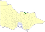
The Shire of Yarrawonga was a Local Government Area located on the Murray River
in the Goulburn Valley
region about 260 kilometres (162 mi) northeast of Melbourne
, the state capital of Victoria
, Australia
. The shire covered an area of 626.78 square kilometres (242 sq mi), and existed from 1891 until 1994.
, formed in 1864 and a Shire from 1871, which extended along the south bank of the Murray River
from Mount Hope Creek in the west to the Ovens River
in the east.
Originally, Yarrawonga was part of the Shire of Tungamah
, which, confusingly, was originally called the Shire of Yarrawonga when it first incorporated on 15 May 1878. On 17 April 1891, the East Riding, which contained the town of Yarrawonga
, was severed and incorporated as the Shire of North Yarrawonga. After the original shire was renamed to Tungamah on 17 February 1893, North Yarrawonga was renamed Yarrawonga on 12 May 1893.
On 18 November 1994, the Shire was abolished, and merged with the Shires of Cobram
, Nathalia
, Numurkah
and Tungamah
into the Shire of Moira. The Peechelba
district, however, was transferred to the Rural City of Wangaratta
.
* Estimate in the 1958 Victorian Year Book.
Murray River
The Murray River is Australia's longest river. At in length, the Murray rises in the Australian Alps, draining the western side of Australia's highest mountains and, for most of its length, meanders across Australia's inland plains, forming the border between New South Wales and Victoria as it...
in the Goulburn Valley
Goulburn Valley
The Goulburn Valley is a region of Victoria, Australia. The region consists of those areas in the catchment of the Goulburn River and other nearby streams, and is part of the Murray-Darling Basin. The Goulburn Valley is bordered on the south by the Great Dividing Range and to the north by the...
region about 260 kilometres (162 mi) northeast of Melbourne
Melbourne
Melbourne is the capital and most populous city in the state of Victoria, and the second most populous city in Australia. The Melbourne City Centre is the hub of the greater metropolitan area and the Census statistical division—of which "Melbourne" is the common name. As of June 2009, the greater...
, the state capital of Victoria
Victoria (Australia)
Victoria is the second most populous state in Australia. Geographically the smallest mainland state, Victoria is bordered by New South Wales, South Australia, and Tasmania on Boundary Islet to the north, west and south respectively....
, Australia
Australia
Australia , officially the Commonwealth of Australia, is a country in the Southern Hemisphere comprising the mainland of the Australian continent, the island of Tasmania, and numerous smaller islands in the Indian and Pacific Oceans. It is the world's sixth-largest country by total area...
. The shire covered an area of 626.78 square kilometres (242 sq mi), and existed from 1891 until 1994.
History
Yarrawonga was once part of the vast Echuca DistrictShire of Rochester
The Shire of Rochester was a Local Government Area of Victoria, Australia, located about north of Melbourne, the state capital, and immediately west and southwest of the town of Echuca...
, formed in 1864 and a Shire from 1871, which extended along the south bank of the Murray River
Murray River
The Murray River is Australia's longest river. At in length, the Murray rises in the Australian Alps, draining the western side of Australia's highest mountains and, for most of its length, meanders across Australia's inland plains, forming the border between New South Wales and Victoria as it...
from Mount Hope Creek in the west to the Ovens River
Ovens River
The Ovens River is a river in the Australian state of Victoria.Hamilton Hume and William Hovell explored the area in 1824, naming the Ovens River...
in the east.
Originally, Yarrawonga was part of the Shire of Tungamah
Shire of Tungamah
The Shire of Tungamah was a Local Government Area located in the Goulburn Valley region about northeast of Melbourne, the state capital of Victoria, Australia...
, which, confusingly, was originally called the Shire of Yarrawonga when it first incorporated on 15 May 1878. On 17 April 1891, the East Riding, which contained the town of Yarrawonga
Yarrawonga, Victoria
Yarrawonga is a town in the Shire of Moira Local Government Area in the Australian state of Victoria. The town is situated on the south bank of the Murray River, the border between Victoria and New South Wales and is located approximately north-east of the state capital, Melbourne. Yarrawonga's...
, was severed and incorporated as the Shire of North Yarrawonga. After the original shire was renamed to Tungamah on 17 February 1893, North Yarrawonga was renamed Yarrawonga on 12 May 1893.
On 18 November 1994, the Shire was abolished, and merged with the Shires of Cobram
Shire of Cobram
The Shire of Cobram was a Local Government Area located on the Murray River in the Goulburn Valley region about north of Melbourne, the state capital of Victoria, Australia. The shire covered an area of , and existed from 1953 until 1994.-History:...
, Nathalia
Shire of Nathalia
The Shire of Nathalia was a Local Government Area located on the Murray River in the Goulburn Valley region about north of Melbourne, the state capital of Victoria, Australia...
, Numurkah
Shire of Numurkah
The Shire of Numurkah was a Local Government Area located on the Murray River in the Goulburn Valley region about north of Melbourne, the state capital of Victoria, Australia...
and Tungamah
Shire of Tungamah
The Shire of Tungamah was a Local Government Area located in the Goulburn Valley region about northeast of Melbourne, the state capital of Victoria, Australia...
into the Shire of Moira. The Peechelba
Peechelba, Victoria
Peechelba is a small town in north eastern Victoria , Australia. The town is located in the Rural City of Wangaratta Local Government Area between Wangaratta and Yarrawonga and north west of the state capital, Melbourne...
district, however, was transferred to the Rural City of Wangaratta
Rural City of Wangaratta
The Rural City of Wangaratta is a Local Government Area in Victoria, Australia. It is located in the north-eastern part of the state. It has an area of 3,764 square kilometres. In 2001 it had a population of 26,000, of which 8.6% were born overseas...
.
Wards
Yarrawonga was divided into four ridings , each of which elected three councillors:- Eastern Town Riding
- Western Town Riding
- Eastern Rural Riding
- Western Rural Riding
Towns and localities
- YarrawongaYarrawonga, VictoriaYarrawonga is a town in the Shire of Moira Local Government Area in the Australian state of Victoria. The town is situated on the south bank of the Murray River, the border between Victoria and New South Wales and is located approximately north-east of the state capital, Melbourne. Yarrawonga's...
- Bathumi
- Boomahnoomoonah
- BundalongBundalong, VictoriaBundalong is a town in Victoria, Australia located on the Murray River and the Murray Valley Highway, east of Yarrawonga. At the 2006 census, Bundalong had a population of 298. Bundalong is in the Shire of Moira Local Government Area, with the name "Bundalong" being the Aboriginal word for "joined...
- Burramine
- PeechelbaPeechelba, VictoriaPeechelba is a small town in north eastern Victoria , Australia. The town is located in the Rural City of Wangaratta Local Government Area between Wangaratta and Yarrawonga and north west of the state capital, Melbourne...
- Wilby
Population
| Year | Population |
|---|---|
| 1911 | 3,109 |
| 1954 | 3,770 |
| 1958 | 4,080* |
| 1961 | 3,724 |
| 1966 | 3,807 |
| 1971 | 3,755 |
| 1976 | 4,072 |
| 1981 | 4,437 |
| 1986 | 4,667 |
| 1991 | 5,521 |
* Estimate in the 1958 Victorian Year Book.