
Shire of Waranga
Encyclopedia
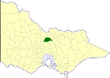
The Shire of Waranga was a Local Government Area located about 165 kilometres (103 mi) north of Melbourne
, the state capital of Victoria
, Australia
. The shire covered an area of 1644.19 square kilometres (634.8 sq mi), and existed from 1863 until 1994.
A large area was annexed to the Shire of Echuca on 10 October 1879, which ended up located within the Shire of Deakin
. The Shire of Rodney
was severed and incorporated on 19 March 1886. On 16 May 1956 another loss of area occurred when Shire of Goulburn
annexed some land in Waranga's southeast.
On 18 November 1994, the Shire was abolished, and merged with the City of Echuca
, the Town of Kyabram
, the Shires of Deakin
and Rochester
and some neighbouring districts into the Shire of Campaspe. The Murchison
district was transferred to the City of Greater Shepparton
.
* Estimate in the 1958 Victorian Year Book.
Melbourne
Melbourne is the capital and most populous city in the state of Victoria, and the second most populous city in Australia. The Melbourne City Centre is the hub of the greater metropolitan area and the Census statistical division—of which "Melbourne" is the common name. As of June 2009, the greater...
, the state capital of Victoria
Victoria (Australia)
Victoria is the second most populous state in Australia. Geographically the smallest mainland state, Victoria is bordered by New South Wales, South Australia, and Tasmania on Boundary Islet to the north, west and south respectively....
, Australia
Australia
Australia , officially the Commonwealth of Australia, is a country in the Southern Hemisphere comprising the mainland of the Australian continent, the island of Tasmania, and numerous smaller islands in the Indian and Pacific Oceans. It is the world's sixth-largest country by total area...
. The shire covered an area of 1644.19 square kilometres (634.8 sq mi), and existed from 1863 until 1994.
History
Waranga was first incorporated as a district on 1 June 1863, and became a shire on 30 October 1865.A large area was annexed to the Shire of Echuca on 10 October 1879, which ended up located within the Shire of Deakin
Shire of Deakin
The Shire of Deakin was a Local Government Area located in the Goulburn Valley region about north of Melbourne, the state capital of Victoria, Australia...
. The Shire of Rodney
Shire of Rodney
The Shire of Rodney was a Local Government Area located in the Goulburn Valley region about north of Melbourne, the state capital of Victoria, Australia, between Kyabram and Shepparton. The shire covered an area of , and existed from 1886 until 1994.-History:...
was severed and incorporated on 19 March 1886. On 16 May 1956 another loss of area occurred when Shire of Goulburn
Shire of Goulburn
The Shire of Goulburn was a Local Government Area located about north of Melbourne, the state capital of Victoria, Australia. The shire covered an area of , and existed from 1868 until 1994.-History:...
annexed some land in Waranga's southeast.
On 18 November 1994, the Shire was abolished, and merged with the City of Echuca
City of Echuca
The City of Echuca was a Local Government Area of Victoria, Australia, located about north of Melbourne, the state capital, on the Murray River in the regional centre of Echuca...
, the Town of Kyabram
Town of Kyabram
The Town of Kyabram was a Local Government Area located in the Goulburn Valley region about north of Melbourne, the state capital of Victoria, Australia, and west of Shepparton. The Town covered an area of , and existed from 1954 until 1994.-History:...
, the Shires of Deakin
Shire of Deakin
The Shire of Deakin was a Local Government Area located in the Goulburn Valley region about north of Melbourne, the state capital of Victoria, Australia...
and Rochester
Shire of Rochester
The Shire of Rochester was a Local Government Area of Victoria, Australia, located about north of Melbourne, the state capital, and immediately west and southwest of the town of Echuca...
and some neighbouring districts into the Shire of Campaspe. The Murchison
Murchison, Victoria
Murchison is a small rural village located on the Goulburn River in Victoria, Australia. Murchison is located 167 kilometres from Melbourne and is just to the west of the Goulburn Valley Highway between Shepparton and Nagambie. The surrounding countryside contains orchards, vineyards and dairy...
district was transferred to the City of Greater Shepparton
City of Greater Shepparton
The City of Greater Shepparton is a Local Government Area in Victoria, Australia. It is located in the northern part of the state. It has an area of 2,420 square kilometres, and in 2001 it had a population of 56,000...
.
Wards
Waranga was divided into four ridings on 5 May 1971, each of which elected three councillors:- North Riding
- South Riding
- East Riding
- West Riding
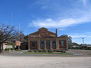
Towns and localities
- ColbinabbinColbinabbin, VictoriaColbinabbin is a small town in central Victoria, Australia. The name is derived from aboriginal meaning "the meeting of the black and red soils"...
- CoropCorop, VictoriaCorop is a town in the Goulburn Valley region of Victoria, Australia. The town is in the Shire of Campaspe and on the Midland Highway, north of the state capital, Melbourne...
- Mathiesons
- MurchisonMurchison, VictoriaMurchison is a small rural village located on the Goulburn River in Victoria, Australia. Murchison is located 167 kilometres from Melbourne and is just to the west of the Goulburn Valley Highway between Shepparton and Nagambie. The surrounding countryside contains orchards, vineyards and dairy...
- RushworthRushworth, VictoriaRushworth is a township in Victoria, Australia. It is located north of Melbourne and, at the 2006 census, had a population of 2066.-History:...
- ToolleenToolleen, VictoriaTooleen is a town in northern Victoria, Australia. The town is located on the Northern Highway and is in the Shire of Campaspe and the City of Greater Bendigo local government areas, north of the state capital, Melbourne...
- Whroo
Population
| Year | Population |
|---|---|
| 1954 | 4,655 |
| 1958 | 4,690* |
| 1961 | 4,528 |
| 1966 | 4,502 |
| 1971 | 4,333 |
| 1976 | 4,187 |
| 1981 | 4,187 |
| 1986 | 4,196 |
| 1991 | 4,396 |
* Estimate in the 1958 Victorian Year Book.