
Shire of Goulburn
Encyclopedia
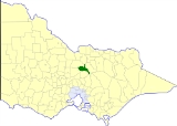
The Shire of Goulburn was a Local Government Area located about 120 kilometres (75 mi) north of Melbourne
, the state capital of Victoria
, Australia
. The shire covered an area of 1016 square kilometres (392.3 sq mi), and existed from 1868 until 1994.
.
On 18 November 1994, the Shire was abolished, and merged with the Shires of Euroa
and Violet Town
and some neighbouring districts into the Shire of Strathbogie.
* Estimate in the 1958 Victorian Year Book.
Melbourne
Melbourne is the capital and most populous city in the state of Victoria, and the second most populous city in Australia. The Melbourne City Centre is the hub of the greater metropolitan area and the Census statistical division—of which "Melbourne" is the common name. As of June 2009, the greater...
, the state capital of Victoria
Victoria (Australia)
Victoria is the second most populous state in Australia. Geographically the smallest mainland state, Victoria is bordered by New South Wales, South Australia, and Tasmania on Boundary Islet to the north, west and south respectively....
, Australia
Australia
Australia , officially the Commonwealth of Australia, is a country in the Southern Hemisphere comprising the mainland of the Australian continent, the island of Tasmania, and numerous smaller islands in the Indian and Pacific Oceans. It is the world's sixth-largest country by total area...
. The shire covered an area of 1016 square kilometres (392.3 sq mi), and existed from 1868 until 1994.
History
Goulburn was first incorporated as a district on 24 November 1868, and became a shire on 24 March 1871. On 16 May 1956, Goulburn annexed some land from the Shire of WarangaShire of Waranga
The Shire of Waranga was a Local Government Area located about north of Melbourne, the state capital of Victoria, Australia. The shire covered an area of , and existed from 1863 until 1994.-History:...
.
On 18 November 1994, the Shire was abolished, and merged with the Shires of Euroa
Shire of Euroa
The Shire of Euroa was a Local Government Area located about northeast of Melbourne, the state capital of Victoria, Australia. The shire covered an area of , and existed from 1879 until 1994.-History:...
and Violet Town
Shire of Violet Town
The Shire of Violet Town was a Local Government Area located about northeast of Melbourne, the state capital of Victoria, Australia. The shire covered an area of , and existed from 1895 until 1994.-History:...
and some neighbouring districts into the Shire of Strathbogie.
Wards
Goulburn was divided into three ridings on 16 May 1956, each of which elected three councillors:- Central Riding
- East Riding
- North Riding
Towns and localities
- NagambieNagambie, VictoriaNagambie is a town in Victoria, Australia, located on the Goulburn Valley Highway, north of Seymour, in the Shire of Strathbogie. At the 2006 census, Nagambie had a population of 1,383.-History:...
- Goulburn WeirGoulburn WeirGoulburn Weir is a weir built between 1887 and early 1891 across the Goulburn River near Nagambie, Victoria, Australia. It was the first major diversion structure built for irrigation development in Australia. The weir also forms Lake Nagambie where rowing regattas and waterskiing tournaments are...
- Graytown
- Locksley
- LongwoodLongwood, VictoriaLongwood is a town in northern Victoria, Australia. The town is located in the Shire of Strathbogie Local government area, from the state capital, Melbourne...
- Mitchellstown
- Moorilim
- RuffyRuffy, VictoriaRuffy is a town in Victoria, Australia. The town is located in the Shire of Strathbogie, north of the state capital, Melbourne. At the 2006 census, Ruffy and the surrounding area had a population of 280...
- Tabilk
- Tarcombe
- Wahring
Population
| Year | Population |
|---|---|
| 1954 | 1,760 |
| 1958 | 2,200* |
| 1961 | 1,900 |
| 1966 | 1,837 |
| 1971 | 2,004 |
| 1976 | 2,060 |
| 1981 | 2,113 |
| 1986 | 2,205 |
| 1991 | 2,535 |
* Estimate in the 1958 Victorian Year Book.