
Shire of Daylesford and Glenlyon
Encyclopedia
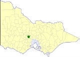
The Shire of Daylesford and Glenlyon was a Local Government Area located about 110 kilometres (68 mi) northwest of Melbourne
, the state capital of Victoria
, Australia
. The shire covered an area of 609.3 square kilometres (235.3 sq mi), and existed from 1860 until 1995.
On 3 May 1966, an Order in Council united the Borough of Daylesford with the Shire of Glenlyon to create the new Shire.
On 20 January 1995, the Shire was abolished, and merged with Shires of Creswick
and parts of Kyneton
and Talbot
into the Shire of Hepburn.
* Estimate in 1958 Victorian Year Book.
Melbourne
Melbourne is the capital and most populous city in the state of Victoria, and the second most populous city in Australia. The Melbourne City Centre is the hub of the greater metropolitan area and the Census statistical division—of which "Melbourne" is the common name. As of June 2009, the greater...
, the state capital of Victoria
Victoria (Australia)
Victoria is the second most populous state in Australia. Geographically the smallest mainland state, Victoria is bordered by New South Wales, South Australia, and Tasmania on Boundary Islet to the north, west and south respectively....
, Australia
Australia
Australia , officially the Commonwealth of Australia, is a country in the Southern Hemisphere comprising the mainland of the Australian continent, the island of Tasmania, and numerous smaller islands in the Indian and Pacific Oceans. It is the world's sixth-largest country by total area...
. The shire covered an area of 609.3 square kilometres (235.3 sq mi), and existed from 1860 until 1995.
History
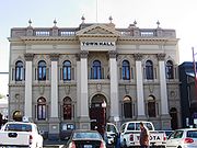
What became the Shire of Daylesford and Glenlyon had its origins in several different local authorities:- The Borough of Daylesford was incorporated on 23 September 1859 with an area of 16.23 km² (6.3 sq mi) surrounding the town of DaylesfordDaylesford, VictoriaDaylesford is a town located in the Shire of Hepburn, Victoria, Australia. It is a former goldmining town about 115 kilometres north-west of Melbourne, in the foothills of the Great Dividing Range. At the 2006 census, Daylesford had a population of 3,073...
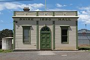
. - The Shire of Glenlyon was incorporated on 24 February 1860 as a district, becoming a shire on 12 December 1865.
- The Shire of Mount Franklin was incorporated on 11 May 1860 as a district, becoming a shire on 27 January 1871. After the passage of the Local Government Amendment Act 1914, it was found that Mount Franklin did not meet the criteria of a shire as its rateable income was below £1,500 per annum, so it was amalgamated on 1 October 1915 with Glenlyon.
On 3 May 1966, an Order in Council united the Borough of Daylesford with the Shire of Glenlyon to create the new Shire.
On 20 January 1995, the Shire was abolished, and merged with Shires of Creswick
Shire of Creswick
The Shire of Creswick was a Local Government Area located about west-northwest of Melbourne, the state capital of Victoria, Australia. The shire covered an area of , and existed from 1859 until 1994.-History:...
and parts of Kyneton
Shire of Kyneton
The Shire of Kyneton was a Local Government Area located about northwest of Melbourne, the state capital of Victoria, Australia. The shire covered an area of , and existed from 1859 until 1995.-History:...
and Talbot
Shire of Talbot and Clunes
The Shire of Talbot and Clunes was a Local Government Area located about northwest of Melbourne, the state capital of Victoria, Australia. The shire covered an area of , and existed from 1860 until 1994.-History:...
into the Shire of Hepburn.
Wards
Daylesford and Glenlyon was divided into four ridings on 31 May 1966, each of which elected three councillors:- Daylesford Riding
- Glenlyon Riding
- Hepburn Riding
- Mount Franklin Riding
Towns and localities
West (Mt Franklin)
|
East (Glenlyon)
|
Population
| Year | Population |
|---|---|
| 1954 | 5,489 |
| 1958 | 5,670* |
| 1961 | 4,645 |
| 1966 | 4,396 |
| 1971 | 4,105 |
| 1976 | 3,971 |
| 1981 | 4,300 |
| 1986 | 4,988 |
| 1991 | 5,679 |
* Estimate in 1958 Victorian Year Book.