
Shire of Creswick
Encyclopedia
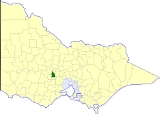
The Shire of Creswick was a Local Government Area located about 120 kilometres (75 mi) west-northwest of Melbourne
, the state capital of Victoria
, Australia
. The shire covered an area of 551.66 square kilometres (213 sq mi), and existed from 1859 until 1994.
On 20 January 1995, the Shire was abolished, and merged with Shires of Daylesford and Glenlyon
and part of Kyneton
and Talbot
into the Shire of Hepburn.
* Estimate in 1958 Victorian Year Book.
Melbourne
Melbourne is the capital and most populous city in the state of Victoria, and the second most populous city in Australia. The Melbourne City Centre is the hub of the greater metropolitan area and the Census statistical division—of which "Melbourne" is the common name. As of June 2009, the greater...
, the state capital of Victoria
Victoria (Australia)
Victoria is the second most populous state in Australia. Geographically the smallest mainland state, Victoria is bordered by New South Wales, South Australia, and Tasmania on Boundary Islet to the north, west and south respectively....
, Australia
Australia
Australia , officially the Commonwealth of Australia, is a country in the Southern Hemisphere comprising the mainland of the Australian continent, the island of Tasmania, and numerous smaller islands in the Indian and Pacific Oceans. It is the world's sixth-largest country by total area...
. The shire covered an area of 551.66 square kilometres (213 sq mi), and existed from 1859 until 1994.
History
Creswick was first incorporated as a district on 11 January 1859, and became a shire on 31 December 1863. The Borough of Creswick, incorporated on 19 November 1858 with an area of 19.26 square kilometres (4,759 acre), was united with the Shire on 29 May 1934.On 20 January 1995, the Shire was abolished, and merged with Shires of Daylesford and Glenlyon
Shire of Daylesford and Glenlyon
The Shire of Daylesford and Glenlyon was a Local Government Area located about northwest of Melbourne, the state capital of Victoria, Australia...
and part of Kyneton
Shire of Kyneton
The Shire of Kyneton was a Local Government Area located about northwest of Melbourne, the state capital of Victoria, Australia. The shire covered an area of , and existed from 1859 until 1995.-History:...
and Talbot
Shire of Talbot and Clunes
The Shire of Talbot and Clunes was a Local Government Area located about northwest of Melbourne, the state capital of Victoria, Australia. The shire covered an area of , and existed from 1860 until 1994.-History:...
into the Shire of Hepburn.
Wards
Creswick was divided into four ridings, each of which elected three councillors:- Creswick Riding
- North Creswick Riding
- Northeast Riding
- South Riding
Towns and localities
- AllendaleAllendale, VictoriaAllendale is a town in Victoria, Australia, located north-east of Creswick, in the Shire of Hepburn. At the 2005 census, Allendale and the surrounding area had a population of 330....
- Broomfield
- BlampiedBlampied, VictoriaBlampied is a town in the central highlands of Victoria on the Midland Highway. The town is in the Shire of Hepburn, north west of the state capital of Melbourne...
- Cabbage Tree
- Campbelltown
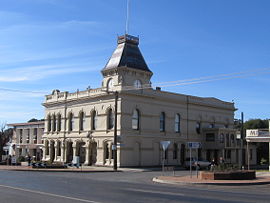
- CreswickCreswick, VictoriaCreswick is a town in west-central Victoria, Australia. It is located 18 kilometres north of Ballarat and 129 km northwest of Melbourne, in Shire of Hepburn. It is 430 metres above sea level. At the 2006 census, Creswick had a population of 2,485...
- Creswick North
- DeanDean, VictoriaDean is a small township in Victoria, Australia. It is located west of the state capital, Melbourne and nearby to Ballarat-Daylesford Road in the Shire of Hepburn. The Dean Post Office opened 2 September 1861 but closed 1980....
- Glengower
- Kangaroo Hills
- KingstonKingston, VictoriaKingston is a small town in rural Shire of Hepburn in Victoria, Australia. Kingston is located about 15 km from Creswick, just off the Midland Highway and is about 20 km from Daylesford. Kingston's post code is 3364....
- Kooroocheang
- Lawrence
- Mollongghip
- Moorookyle
- Mount Prospect
- NewlynNewlyn, VictoriaNewlyn, Victoria is a town in Shire of Hepburn, west-central Victoria, Australia. It is located northeast of Ballarat and northwest of Melbourne.It is 452 metres above sea level....
- Rockyn
- SmeatonSmeaton, VictoriaSmeaton is a rural town in the state of Victoria, Australia near the town of Creswick. At the 2006 census, Smeaton had a population of 250....
- Springmount
- Ullina
- Wattle Flat
Population
| Year | Population |
|---|---|
| 1954 | 3,554 |
| 1958 | 3,690* |
| 1961 | 3,587 |
| 1966 | 3,540 |
| 1971 | 3,414 |
| 1976 | 3,923 |
| 1981 | 3,943 |
| 1986 | 4,482 |
| 1991 | 4,836 |
* Estimate in 1958 Victorian Year Book.