

Shawnee County, Kansas
Encyclopedia
Shawnee County is a county located in northeast Kansas
, in the central
United States of America
. Its most populous city, Topeka
, is the state capital and county seat
. The county's population was 177,934 for the 2010 census. The county along with Jackson
, Jefferson
, Osage
, and Wabaunsee
counties is included in the Topeka Metropolitan Statistical Area
, which had an estimated population of 230,824 in 2009.
The county was one of the original 33 counties created by the first territorial legislature in 1855, and it was named for the Shawnee
tribe of Native Americans
.
 Before the treaty of 1854, the area now known as Shawnee County was inhabited by Shawnee, Kansas, and Pottowatomie Indian tribes. Westward expansion brought the country its first white settler in 1830 when Frederick Choteau opened a trading post on American Chief (now Mission
) Creek. In 1855, Shawnee became one of the first counties established by the Kansas territorial legislature with a population of 250. General H. J. Strickler, of Tecumseh, who was a member of the council in 1855, and also of the joint committee on Counties, claimed Shawnee for the name of his county. At that time, Shawnee County borders were entirely south of the Kansas River and extended south to include Osage City and Carbondale. The legislature later desired to make Topeka the county seat and moved the borders of the county to their present locations to make Topeka centrally located in the county.
1855 also saw the first ever meeting of the Shawnee County Board of Commissioners. Tecumseh was the first county seat, and the first county courthouse was opened there in 1856. The building was 40x50 feet but was never finished. Topeka was made the county seat by popular vote in 1858, and a new courthouse was built at 4th Street and Kansas Avenue in 1867. In 1896, a new larger courthouse was constructed at 5th and Van Buren, with more than 50,000 residents then living in the county. That building remained in use until the current courthouse at 7th and Quincy opened in 1965.
Topeka: A good place to grow potatoes (Prairie potatoes)
Wakarusa:
Shunganunga:
Menoken:
Half-Day Creek: named after a Pottawatomie chief.
Mission Creek: so called because of the old Kaw mission on its banks.
Blacksmith Creek: from the Kaw blacksmith shop.
Soldier Creek: because its banks were a favorite camping ground for soldiers passing from Fort Leavenworth to Fort Riley.
, in the third tier of counties west of the Missouri River
and about fifty-four miles south of Nebraska
. It is bordered by Jackson County
on the north, Jefferson County
on the north and east, Douglas County
on the east, Osage County
on the south, Wabaunsee County
on the west, and Pottawatomie County
on the west. Its extent in either direction is not more than twenty-four miles. According to the 2000 census, the county has a total area of 556.32 square miles (1,440.9 km²), of which 549.82 square miles (1,424 km²) (or 98.83%) is land and 6.5 square miles (16.8 km²) (or 1.17%) is water. The second standard parallel south passes through the northern half of the county.
When the county was originally formed in 1855, it was bounded by the Kansas River
on the north, and the southern boundary was nine miles (14 km) further south. But on February 23, 1860, the legislature changed the boundaries with the southern portion being granted to Osage County
, and the northern boundary was moved a few miles north of the river (to the second standard parallel). The present northern line (six miles north of the second standard parallel) was established in 1868.
: Soldier, Menoken, Silver Lake, Grove, and Rossville north of the Kansas River
; Tecumseh, Topeka, Mission, and Dover south of the river; and Monmouth, Williamsport, and Auburn in the southernmost tier of townships occupying the Wakarusa River
valley. Being a city
of the first class, the city of Topeka
is independent of any townships and excluded from the census figures for the townships. It occupies over ten percent of the county's land area and ranks fourth in population among all cities in Kansas. Altogether, the county has five incorporated
cities with the other four being cities of the third class: Auburn
, Rossville
, Silver Lake
, and Willard
.
Tecumseh Township was one of the two original townships formed in 1855, and it originally extended over all the county south of the Kansas River to the Wakarusa River. Yocum Township, named after county commissioner William Yocum, was the other, and it contained the area south of the Wakarusa River. The formation of the townships of Topeka (1857) and Monmouth (1860) reduced Tecumseh Township to its current greatest extent of about seven miles (11 km) from north to south from the Kansas River and less than seven miles (11 km) from east to west from the county's eastern border. Small portions in the western part have been annexed by the city of Topeka, and its present area is 36 square miles (93.2 km²). It contains the (unincorporated) towns of Tecumseh
, Spencer, and Watson. The town and township were named for the famous Shawnee chief
.
Topeka Township was carved out of the western portion of Tecumseh Township in 1857. Following the creation of newer townships and annexations by the city of Topeka, the size of the township has been significantly reduced. It currently occupies an area of 12 square miles (31.1 km²), and it is in extent about three miles (5 km) from north to south and five miles (8 km) from east to west. It contains the town of Pauline
.
Monmouth Township, located in the southeastern corner of the county, has an area of 56 square miles (145 km²). In extent it is eight miles (13 km) north to south and seven miles (11 km) east to west. It contains the town of Berryton
. Richland
, which was located in the far southeast corner of the township, was purchased by the U.S. Army Corps of Engineers in the late 1960s as a part of the land acquired for Clinton Lake. By 1974, the town was vacated and the remaining buildings were demolished shortly thereafter.
Williamsport Township, established in 1860, was named after Williamsport
, Pennsylvania
. With an area of 41 square miles (106.2 km²), it is in extent six miles (10 km) from north to south to the county's southern border and seven miles (11 km) from east to west between Monmouth and Auburn townships. It contains the towns of Wakarusa
and Cullen Village and the greater portion of Forbes Field (airport).
Auburn Township, 56 square miles (145 km²) in area, occupies the southwestern corner of the county. In extent it is six miles (10 km) from north to south and ten miles (16 km) from east to west, and it contains the city of Auburn.
Dover Township was carved from northern portions of Auburn Township in 1867 and named after Dover
, New Hampshire
. In extent it is twelve miles (19 km) from north to south from the Kansas River and six miles (10 km) from east to west to the county's western border, with an area of 57 square miles (147.6 km²). It includes the city of Willard and the towns of Dover
and Valencia.
Mission Township was formed from portions of Dover and Topeka townships in 1871. Northeastern portions of the township have been annexed by the city of Topeka in years since. It currently occupies an area of 32 square miles (82.9 km²), and its greatest extent is not more than eight miles (13 km) from north to south and six miles (10 km) from east to west. It contains numerous subdivisions and the Sherwood Lake area.
Soldier Township was organized following the change in the county's borders in 1860, and it contained all of the county north of the Kansas River until the formation of Silver Lake Township in 1868. A southern portion of the township has been annexed by the city of Topeka. With an area of 63 square miles (163.2 km²), it is in extent less than ten miles (16 km) from north to south from the county's northern border and less than eight miles (13 km) from east to west from the county's eastern border. It contains the town of Elmont
.
Silver Lake Township was carved out of the western portion of Soldier Township after the county's northern border was moved in 1868. The formation of the surrounding townships of Rossville (1871) to the west, Menoken (1879) to the east, and Grove (1918) to the north has reduced the size of the township. With an area of 18 square miles (46.6 km²), its greatest extent is about five miles (8 km) from north to south to the Kansas River and five miles (8 km) from east to west. It contains the city of Silver Lake, and it is named after a crescent
-shaped lake located near the city.
Rossville Township, occupying the northwestern corner of the county, was carved out of the western part of Silver Lake Township in 1871. It has an area of 52 square miles (134.7 km²), and its greatest extent is about nine miles (14 km) from north to south to the Kansas River and seven miles (11 km) from east to west. It includes the city of Rossville. The township and city were both named for William W. Ross, the brother of Senator Edmund G. Ross
.
Menoken Township, 45 square miles (116.5 km²) in area, was carved out of the eastern portions of Silver Lake Township in 1879. Extending from the county's northern border to the Kansas River, it is not more than eleven miles (18 km) in extent from north to south and less than five miles (8 km) from east to west. The township's name is derived from a Native American word meaning "fine growth" or "a place for fine growing".
Grove Township is the youngest of the townships. It was carved out of the northern portion of Silver Lake Township in 1918. Very little remains of its only town, Grove. With an area of 30 square miles (77.7 km²), the township is six miles (10 km) in extent from north to south from the county's northern border and five miles (8 km) from east to west between Menoken and Rossville townships.
runs east across the county, just north of the center, being bordered on its north bank by the townships of Rossville, Silver Lake, Menoken, and Soldier, and on its south bank by the townships of Dover, Mission, and Tecumseh. The city of Topeka primarily lies to the south of the river. There is little or no current major river traffic, but it is used extensively for irrigation in the county. Major creeks emptying into the Kansas River include Cross, Soldier, Mission, Indian, and Shunganunga Creeks. The Wakarusa River
, which, flowing east and northeast, empties into the Kansas River in the northeastern part of Douglas County
. It has its sources in the township of Auburn, and waters the southern sections of Auburn, Williamsport and Monmouth—the tributary creeks flowing into it on either side forming the drainage and water system of the three townships.
The soil is a rich dark loam, varying from fifteen feet in some parts of the bottoms, to a uniform surface covering the upland prairie from one to three feet. The underlying formation is limestone. Beds of clay, are well distributed. Coal is found in detached and non-continuous beds, and is mined in a small way for local purposes in Topeka, Soldier and Menoken.
Along the western border the landscape is hilly with the Flint Hills
a few miles further west in Wabaunsee County. Burnett's Mound, the highest point in the county, is situated in the southwest part of Topeka. The land is described in the government and county surveys as "bottom land, 31%; upland, 69%; forest 8%; prairie, 92%." Wooded areas are mainly found along rivers and creeks with no true forests. The growth consists of elm, cottonwood, black walnut, oak, sycamore, box elder, hickory and ash.
As of the U.S. Census in 2000
, there were 169,871 people, 68,920 households, and 44,660 families residing in the county. The population density
was 309 people per square mile (119/km2). There were 73,768 housing units at an average density of 134 per square mile (52/km2). The racial makeup of the county was 82.89% White
, 9.03% Black
or African American
, 1.17% Native American
, 0.95% Asian
, 0.04% Pacific Islander
, 3.20% from other races
, and 2.72% from two or more races. 7.26% of the population were Hispanic
or Latino
of any race.
 There were 68,920 household
s out of which 30.70% had children under the age of 18 living with them, 49.60% were married couples
living together, 11.60% had a female householder with no husband present, and 35.20% were non-families. 29.80% of all households were made up of individuals and 10.00% had someone living alone who was 65 years of age or older. The average household size was 2.39 and the average family size was 2.98.
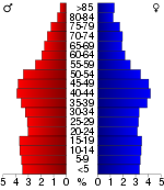
In the county the population was spread out with 25.30% under the age of 18, 8.80% from 18 to 24, 28.40% from 25 to 44, 23.70% from 45 to 64, and 13.70% who were 65 years of age or older. The median age was 37 years. For every 100 females there were 93.80 males. For every 100 females age 18 and over, there were 90.00 males.
The median income for a household
in the county was $40,988, and the median income for a family was $51,464. Males had a median income of $35,586 versus $26,491 for females. The per capita income
for the county was $20,904. About 6.30% of families and 9.60% of the population were below the poverty line, including 12.30% of those under age 18 and 7.10% of those age 65 or over.
", county until the Kansas Constitution was amended in 1986 and voters approved the sale of alcoholic liquor by the individual drink with a 30% food sales requirement. The food sales requirement was removed with voter approval in 1994.
won Shawnee County over Democrat Barack Obama
by a margin of 49.05% to 48.77% a margin of 241 votes.http://uselectionatlas.org/RESULTS/statesub.php?year=2008&fips=20177&f=0&off=0&elect=0
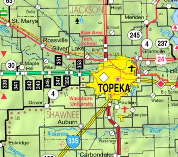
. U.S. Route 75 crosses the county north to south and U.S. Route 40 and U.S. Route 24 cross the county west to east. K-4
serves part of the county from Dover in the southwest corner through Topeka, across the Kansas River and north into Jefferson County.
Forbes Field
Air National Guard base and airport is located south of Topeka near Pauline. The airport was served by Allegiant Air
with biweekley service to Las Vegas
. Other airports in the county include Philip Billard Municipal Airport
in the Oakland neighborhood of Topeka.
is considered governmentally independent and is excluded from the census figures for the townships. In the following table, the population center is the city included in that township's population total.
General Information
Maps
Kansas
Kansas is a US state located in the Midwestern United States. It is named after the Kansas River which flows through it, which in turn was named after the Kansa Native American tribe, which inhabited the area. The tribe's name is often said to mean "people of the wind" or "people of the south...
, in the central
Central United States
The Central United States is sometimes conceived as between the Eastern United States and Western United States as part of a three-region model, roughly coincident with the Midwestern United States plus the western and central portions of the Southern United States; the term is also sometimes used...
United States of America
United States
The United States of America is a federal constitutional republic comprising fifty states and a federal district...
. Its most populous city, Topeka
Topeka, Kansas
Topeka |Kansa]]: Tó Pee Kuh) is the capital city of the U.S. state of Kansas and the county seat of Shawnee County. It is situated along the Kansas River in the central part of Shawnee County, located in northeast Kansas, in the Central United States. As of the 2010 census, the city population was...
, is the state capital and county seat
County seat
A county seat is an administrative center, or seat of government, for a county or civil parish. The term is primarily used in the United States....
. The county's population was 177,934 for the 2010 census. The county along with Jackson
Jackson County, Kansas
Jackson County is a county located in Northeast Kansas, in the Central United States. As of the 2010 census, the county population was 13,462. Its county seat and most populous city is Holton...
, Jefferson
Jefferson County, Kansas
Jefferson County is a county located in Northeast Kansas, in the Central United States. As of the 2010 census, the county population was 19,126. Its county seat is Oskaloosa, and its most populous city is Valley Falls...
, Osage
Osage County, Kansas
Osage County is a county located in east-central Kansas, in the Central United States. As of the 2010 census, the county population was 16295. Its county seat is Lyndon, and its most populous city is Osage City. The county along with Shawnee, Jackson, Jefferson, and Wabaunsee counties is...
, and Wabaunsee
Wabaunsee County, Kansas
Wabaunsee County is a county located in the U.S. state of Kansas. As of the 2010 census, the county population was 7,053. Its county seat is Alma. It is part of the Topeka, Kansas Metropolitan Statistical Area...
counties is included in the Topeka Metropolitan Statistical Area
Topeka metropolitan area
The Topeka Metropolitan Statistical Area, as defined by the United States Census Bureau, is an area consisting of five counties in northeastern Kansas, anchored by the city of Topeka...
, which had an estimated population of 230,824 in 2009.
The county was one of the original 33 counties created by the first territorial legislature in 1855, and it was named for the Shawnee
Shawnee
The Shawnee, Shaawanwaki, Shaawanooki and Shaawanowi lenaweeki, are an Algonquian-speaking people native to North America. Historically they inhabited the areas of Ohio, Virginia, West Virginia, Western Maryland, Kentucky, Indiana, and Pennsylvania...
tribe of Native Americans
Native Americans in the United States
Native Americans in the United States are the indigenous peoples in North America within the boundaries of the present-day continental United States, parts of Alaska, and the island state of Hawaii. They are composed of numerous, distinct tribes, states, and ethnic groups, many of which survive as...
.
History
Mission Creek (Kansas)
Mission Creek is a water body west of Topeka, Kansas. The tributary of the Kansas River goes through Wabaunsee County and Shawnee County, Kansas . Native American tribes lived in the area during the Kansas Territory years. It was an important Underground Railroad site...
) Creek. In 1855, Shawnee became one of the first counties established by the Kansas territorial legislature with a population of 250. General H. J. Strickler, of Tecumseh, who was a member of the council in 1855, and also of the joint committee on Counties, claimed Shawnee for the name of his county. At that time, Shawnee County borders were entirely south of the Kansas River and extended south to include Osage City and Carbondale. The legislature later desired to make Topeka the county seat and moved the borders of the county to their present locations to make Topeka centrally located in the county.
1855 also saw the first ever meeting of the Shawnee County Board of Commissioners. Tecumseh was the first county seat, and the first county courthouse was opened there in 1856. The building was 40x50 feet but was never finished. Topeka was made the county seat by popular vote in 1858, and a new courthouse was built at 4th Street and Kansas Avenue in 1867. In 1896, a new larger courthouse was constructed at 5th and Van Buren, with more than 50,000 residents then living in the county. That building remained in use until the current courthouse at 7th and Quincy opened in 1965.
Local etymologies
Concerning the origin of the names in this county, it is generally understood that Shawnee County receives its name from that well known tribe of Indians.Topeka: A good place to grow potatoes (Prairie potatoes)
Wakarusa:
Shunganunga:
Menoken:
Half-Day Creek: named after a Pottawatomie chief.
Mission Creek: so called because of the old Kaw mission on its banks.
Blacksmith Creek: from the Kaw blacksmith shop.
Soldier Creek: because its banks were a favorite camping ground for soldiers passing from Fort Leavenworth to Fort Riley.
Geography
Shawnee County is located in the northeastern part of KansasKansas
Kansas is a US state located in the Midwestern United States. It is named after the Kansas River which flows through it, which in turn was named after the Kansa Native American tribe, which inhabited the area. The tribe's name is often said to mean "people of the wind" or "people of the south...
, in the third tier of counties west of the Missouri River
Missouri River
The Missouri River flows through the central United States, and is a tributary of the Mississippi River. It is the longest river in North America and drains the third largest area, though only the thirteenth largest by discharge. The Missouri's watershed encompasses most of the American Great...
and about fifty-four miles south of Nebraska
Nebraska
Nebraska is a state on the Great Plains of the Midwestern United States. The state's capital is Lincoln and its largest city is Omaha, on the Missouri River....
. It is bordered by Jackson County
Jackson County, Kansas
Jackson County is a county located in Northeast Kansas, in the Central United States. As of the 2010 census, the county population was 13,462. Its county seat and most populous city is Holton...
on the north, Jefferson County
Jefferson County, Kansas
Jefferson County is a county located in Northeast Kansas, in the Central United States. As of the 2010 census, the county population was 19,126. Its county seat is Oskaloosa, and its most populous city is Valley Falls...
on the north and east, Douglas County
Douglas County, Kansas
Douglas County is a county located in northeast Kansas, in the Central United States. As of the 2010 census, the county population was 110,826...
on the east, Osage County
Osage County, Kansas
Osage County is a county located in east-central Kansas, in the Central United States. As of the 2010 census, the county population was 16295. Its county seat is Lyndon, and its most populous city is Osage City. The county along with Shawnee, Jackson, Jefferson, and Wabaunsee counties is...
on the south, Wabaunsee County
Wabaunsee County, Kansas
Wabaunsee County is a county located in the U.S. state of Kansas. As of the 2010 census, the county population was 7,053. Its county seat is Alma. It is part of the Topeka, Kansas Metropolitan Statistical Area...
on the west, and Pottawatomie County
Pottawatomie County, Kansas
Pottawatomie County is a county located in the U.S. state of Kansas. As of the 2010 census, the county population was 21,604. The county seat is Westmoreland. The county takes its name from the Potawatomi tribe of Native Americans...
on the west. Its extent in either direction is not more than twenty-four miles. According to the 2000 census, the county has a total area of 556.32 square miles (1,440.9 km²), of which 549.82 square miles (1,424 km²) (or 98.83%) is land and 6.5 square miles (16.8 km²) (or 1.17%) is water. The second standard parallel south passes through the northern half of the county.
When the county was originally formed in 1855, it was bounded by the Kansas River
Kansas River
The Kansas River is a river in northeastern Kansas in the United States. It is the southwestern-most part of the Missouri River drainage, which is in turn the northwestern-most portion of the extensive Mississippi River drainage. Its name come from the Kanza people who once inhabited the area...
on the north, and the southern boundary was nine miles (14 km) further south. But on February 23, 1860, the legislature changed the boundaries with the southern portion being granted to Osage County
Osage County, Kansas
Osage County is a county located in east-central Kansas, in the Central United States. As of the 2010 census, the county population was 16295. Its county seat is Lyndon, and its most populous city is Osage City. The county along with Shawnee, Jackson, Jefferson, and Wabaunsee counties is...
, and the northern boundary was moved a few miles north of the river (to the second standard parallel). The present northern line (six miles north of the second standard parallel) was established in 1868.
Adjacent Counties
- Jackson CountyJackson County, KansasJackson County is a county located in Northeast Kansas, in the Central United States. As of the 2010 census, the county population was 13,462. Its county seat and most populous city is Holton...
- north - Jefferson CountyJefferson County, KansasJefferson County is a county located in Northeast Kansas, in the Central United States. As of the 2010 census, the county population was 19,126. Its county seat is Oskaloosa, and its most populous city is Valley Falls...
- northeast - Douglas CountyDouglas County, KansasDouglas County is a county located in northeast Kansas, in the Central United States. As of the 2010 census, the county population was 110,826...
- southeast - Osage CountyOsage County, KansasOsage County is a county located in east-central Kansas, in the Central United States. As of the 2010 census, the county population was 16295. Its county seat is Lyndon, and its most populous city is Osage City. The county along with Shawnee, Jackson, Jefferson, and Wabaunsee counties is...
- south - Wabaunsee CountyWabaunsee County, KansasWabaunsee County is a county located in the U.S. state of Kansas. As of the 2010 census, the county population was 7,053. Its county seat is Alma. It is part of the Topeka, Kansas Metropolitan Statistical Area...
- west - Pottawatomie CountyPottawatomie County, KansasPottawatomie County is a county located in the U.S. state of Kansas. As of the 2010 census, the county population was 21,604. The county seat is Westmoreland. The county takes its name from the Potawatomi tribe of Native Americans...
- northwest
Township divisions
The county consists of twelve townshipsCivil township
A civil township is a widely used unit of local government in the United States, subordinate to, and geographic divisions of, a county. Specific responsibilities and the degree of autonomy vary based on each state. Civil townships are distinct from survey townships, but in states that have both,...
: Soldier, Menoken, Silver Lake, Grove, and Rossville north of the Kansas River
Kansas River
The Kansas River is a river in northeastern Kansas in the United States. It is the southwestern-most part of the Missouri River drainage, which is in turn the northwestern-most portion of the extensive Mississippi River drainage. Its name come from the Kanza people who once inhabited the area...
; Tecumseh, Topeka, Mission, and Dover south of the river; and Monmouth, Williamsport, and Auburn in the southernmost tier of townships occupying the Wakarusa River
Wakarusa River
The Wakarusa River is a tributary of the Kansas River, approximately long, in eastern Kansas in the United States. It drains an agricultural area of rolling limestone hills south of Topeka and Lawrence.-Description:...
valley. Being a city
City
A city is a relatively large and permanent settlement. Although there is no agreement on how a city is distinguished from a town within general English language meanings, many cities have a particular administrative, legal, or historical status based on local law.For example, in the U.S...
of the first class, the city of Topeka
Topeka, Kansas
Topeka |Kansa]]: Tó Pee Kuh) is the capital city of the U.S. state of Kansas and the county seat of Shawnee County. It is situated along the Kansas River in the central part of Shawnee County, located in northeast Kansas, in the Central United States. As of the 2010 census, the city population was...
is independent of any townships and excluded from the census figures for the townships. It occupies over ten percent of the county's land area and ranks fourth in population among all cities in Kansas. Altogether, the county has five incorporated
Municipal corporation
A municipal corporation is the legal term for a local governing body, including cities, counties, towns, townships, charter townships, villages, and boroughs. Municipal incorporation occurs when such municipalities become self-governing entities under the laws of the state or province in which...
cities with the other four being cities of the third class: Auburn
Auburn, Kansas
Auburn is a city in Shawnee County, Kansas, United States. It is part of the Topeka, Kansas Metropolitan Statistical Area. The population was 1,121 at the 2000 census.- History :...
, Rossville
Rossville, Kansas
Rossville is a city in Shawnee County, Kansas, United States. The population was 1,014 at the 2000 census. It is part of the Topeka, Kansas Metropolitan Statistical Area.-History:...
, Silver Lake
Silver Lake, Kansas
Silver Lake is a city in Shawnee County, Kansas, United States. As of the 2010 census, the city population was 1,439. It is part of the Topeka, Kansas Metropolitan Statistical Area.-20th century:...
, and Willard
Willard, Kansas
Willard is a city in Shawnee and Wabaunsee counties in the U.S. state of Kansas. The population was 86 at the 2000 census. It is part of the Topeka, Kansas Metropolitan Statistical Area.-History:...
.
Tecumseh Township was one of the two original townships formed in 1855, and it originally extended over all the county south of the Kansas River to the Wakarusa River. Yocum Township, named after county commissioner William Yocum, was the other, and it contained the area south of the Wakarusa River. The formation of the townships of Topeka (1857) and Monmouth (1860) reduced Tecumseh Township to its current greatest extent of about seven miles (11 km) from north to south from the Kansas River and less than seven miles (11 km) from east to west from the county's eastern border. Small portions in the western part have been annexed by the city of Topeka, and its present area is 36 square miles (93.2 km²). It contains the (unincorporated) towns of Tecumseh
Tecumseh, Kansas
Tecumseh is an unincorporated community situated along the Kansas River in eastern Shawnee County, located in northeast Kansas, in the central United States of America. It is part of the Topeka, Kansas Metropolitan Statistical Area. Although official populations are not compiled for...
, Spencer, and Watson. The town and township were named for the famous Shawnee chief
Tecumseh
Tecumseh was a Native American leader of the Shawnee and a large tribal confederacy which opposed the United States during Tecumseh's War and the War of 1812...
.
Topeka Township was carved out of the western portion of Tecumseh Township in 1857. Following the creation of newer townships and annexations by the city of Topeka, the size of the township has been significantly reduced. It currently occupies an area of 12 square miles (31.1 km²), and it is in extent about three miles (5 km) from north to south and five miles (8 km) from east to west. It contains the town of Pauline
Pauline, Kansas
Pauline is an unincorporated town in Shawnee County, Kansas, United States. Located south of Topeka, it lies next to Forbes Field. Although it began as a small town in its own right, Pauline now is occasionally seen as part of the South City Industry Park for Topeka, Kansas with its many large...
.
Monmouth Township, located in the southeastern corner of the county, has an area of 56 square miles (145 km²). In extent it is eight miles (13 km) north to south and seven miles (11 km) east to west. It contains the town of Berryton
Berryton, Kansas
Berryton is an unincorporated community in Monmouth Township, Shawnee County, Kansas, United States. It has its own post office and elementary school and is part of Shawnee Heights Unified School District 450....
. Richland
Richland, Kansas
Richland was a town in southeastern Shawnee County, Kansas. It is notable for being the birthplace of Georgia Neese Clark Gray, the first female Treasurer of the United States.-History:...
, which was located in the far southeast corner of the township, was purchased by the U.S. Army Corps of Engineers in the late 1960s as a part of the land acquired for Clinton Lake. By 1974, the town was vacated and the remaining buildings were demolished shortly thereafter.
Williamsport Township, established in 1860, was named after Williamsport
Williamsport, Pennsylvania
Williamsport is a city in and the county seat of Lycoming County, Pennsylvania in the United States. In 2009, the population was estimated at 29,304...
, Pennsylvania
Pennsylvania
The Commonwealth of Pennsylvania is a U.S. state that is located in the Northeastern and Mid-Atlantic regions of the United States. The state borders Delaware and Maryland to the south, West Virginia to the southwest, Ohio to the west, New York and Ontario, Canada, to the north, and New Jersey to...
. With an area of 41 square miles (106.2 km²), it is in extent six miles (10 km) from north to south to the county's southern border and seven miles (11 km) from east to west between Monmouth and Auburn townships. It contains the towns of Wakarusa
Wakarusa, Kansas
Wakarusa is an unincorporated community and census-designated place in Shawnee County, Kansas, United States. Wakarusa is south of downtown Topeka. Wakarusa has a post office with ZIP code 66546. As of the 2010 census, its population was 260....
and Cullen Village and the greater portion of Forbes Field (airport).
Auburn Township, 56 square miles (145 km²) in area, occupies the southwestern corner of the county. In extent it is six miles (10 km) from north to south and ten miles (16 km) from east to west, and it contains the city of Auburn.
Dover Township was carved from northern portions of Auburn Township in 1867 and named after Dover
Dover, New Hampshire
Dover is a city in Strafford County, New Hampshire, in the United States of America. The population was 29,987 at the 2010 census, the largest in the New Hampshire Seacoast region...
, New Hampshire
New Hampshire
New Hampshire is a state in the New England region of the northeastern United States of America. The state was named after the southern English county of Hampshire. It is bordered by Massachusetts to the south, Vermont to the west, Maine and the Atlantic Ocean to the east, and the Canadian...
. In extent it is twelve miles (19 km) from north to south from the Kansas River and six miles (10 km) from east to west to the county's western border, with an area of 57 square miles (147.6 km²). It includes the city of Willard and the towns of Dover
Dover, Kansas
Dover is an unincorporated community on the banks of Mission Creek in western Shawnee County, Kansas, United States. Founded in 1860, it was once a larger community, but it declined for most of the 20th century. Today a few commercial buildings remain at the intersection of K-4 Highway and 57th...
and Valencia.
Mission Township was formed from portions of Dover and Topeka townships in 1871. Northeastern portions of the township have been annexed by the city of Topeka in years since. It currently occupies an area of 32 square miles (82.9 km²), and its greatest extent is not more than eight miles (13 km) from north to south and six miles (10 km) from east to west. It contains numerous subdivisions and the Sherwood Lake area.
Soldier Township was organized following the change in the county's borders in 1860, and it contained all of the county north of the Kansas River until the formation of Silver Lake Township in 1868. A southern portion of the township has been annexed by the city of Topeka. With an area of 63 square miles (163.2 km²), it is in extent less than ten miles (16 km) from north to south from the county's northern border and less than eight miles (13 km) from east to west from the county's eastern border. It contains the town of Elmont
Elmont, Kansas
Elmont is an unincorporated community in northern Shawnee County, Kansas, United States. Today Elmont has a church. It also has a elementary school operated by * Schools....
.
Silver Lake Township was carved out of the western portion of Soldier Township after the county's northern border was moved in 1868. The formation of the surrounding townships of Rossville (1871) to the west, Menoken (1879) to the east, and Grove (1918) to the north has reduced the size of the township. With an area of 18 square miles (46.6 km²), its greatest extent is about five miles (8 km) from north to south to the Kansas River and five miles (8 km) from east to west. It contains the city of Silver Lake, and it is named after a crescent
Crescent
In art and symbolism, a crescent is generally the shape produced when a circular disk has a segment of another circle removed from its edge, so that what remains is a shape enclosed by two circular arcs of different diameters which intersect at two points .In astronomy, a crescent...
-shaped lake located near the city.
Rossville Township, occupying the northwestern corner of the county, was carved out of the western part of Silver Lake Township in 1871. It has an area of 52 square miles (134.7 km²), and its greatest extent is about nine miles (14 km) from north to south to the Kansas River and seven miles (11 km) from east to west. It includes the city of Rossville. The township and city were both named for William W. Ross, the brother of Senator Edmund G. Ross
Edmund G. Ross
Edmund Gibson Ross was a politician who represented the state of Kansas after the American Civil War and was later governor of the New Mexico Territory. His vote against convicting of President Andrew Johnson of "high crimes and misdemeanors" allowed Johnson to stay in office by the margin of one...
.
Menoken Township, 45 square miles (116.5 km²) in area, was carved out of the eastern portions of Silver Lake Township in 1879. Extending from the county's northern border to the Kansas River, it is not more than eleven miles (18 km) in extent from north to south and less than five miles (8 km) from east to west. The township's name is derived from a Native American word meaning "fine growth" or "a place for fine growing".
Grove Township is the youngest of the townships. It was carved out of the northern portion of Silver Lake Township in 1918. Very little remains of its only town, Grove. With an area of 30 square miles (77.7 km²), the township is six miles (10 km) in extent from north to south from the county's northern border and five miles (8 km) from east to west between Menoken and Rossville townships.
Natural features
The Kansas RiverKansas River
The Kansas River is a river in northeastern Kansas in the United States. It is the southwestern-most part of the Missouri River drainage, which is in turn the northwestern-most portion of the extensive Mississippi River drainage. Its name come from the Kanza people who once inhabited the area...
runs east across the county, just north of the center, being bordered on its north bank by the townships of Rossville, Silver Lake, Menoken, and Soldier, and on its south bank by the townships of Dover, Mission, and Tecumseh. The city of Topeka primarily lies to the south of the river. There is little or no current major river traffic, but it is used extensively for irrigation in the county. Major creeks emptying into the Kansas River include Cross, Soldier, Mission, Indian, and Shunganunga Creeks. The Wakarusa River
Wakarusa River
The Wakarusa River is a tributary of the Kansas River, approximately long, in eastern Kansas in the United States. It drains an agricultural area of rolling limestone hills south of Topeka and Lawrence.-Description:...
, which, flowing east and northeast, empties into the Kansas River in the northeastern part of Douglas County
Douglas County, Kansas
Douglas County is a county located in northeast Kansas, in the Central United States. As of the 2010 census, the county population was 110,826...
. It has its sources in the township of Auburn, and waters the southern sections of Auburn, Williamsport and Monmouth—the tributary creeks flowing into it on either side forming the drainage and water system of the three townships.
The soil is a rich dark loam, varying from fifteen feet in some parts of the bottoms, to a uniform surface covering the upland prairie from one to three feet. The underlying formation is limestone. Beds of clay, are well distributed. Coal is found in detached and non-continuous beds, and is mined in a small way for local purposes in Topeka, Soldier and Menoken.
Along the western border the landscape is hilly with the Flint Hills
Flint Hills
The Flint Hills, historically known as Bluestem Pastures or Blue Stem Hills, are a band of hills in eastern Kansas stretching into north-central Oklahoma, extending from Marshall County, Kansas and Washington County, Kansas in the north to Cowley County, Kansas and Osage County, Oklahoma in the south...
a few miles further west in Wabaunsee County. Burnett's Mound, the highest point in the county, is situated in the southwest part of Topeka. The land is described in the government and county surveys as "bottom land, 31%; upland, 69%; forest 8%; prairie, 92%." Wooded areas are mainly found along rivers and creeks with no true forests. The growth consists of elm, cottonwood, black walnut, oak, sycamore, box elder, hickory and ash.
Demographics
Shawnee County's population was estimated to be 176,255 in the year 2009, an increase of 6,384, or +3.8%, over the previous nine years.As of the U.S. Census in 2000
United States Census, 2000
The Twenty-second United States Census, known as Census 2000 and conducted by the Census Bureau, determined the resident population of the United States on April 1, 2000, to be 281,421,906, an increase of 13.2% over the 248,709,873 persons enumerated during the 1990 Census...
, there were 169,871 people, 68,920 households, and 44,660 families residing in the county. The population density
Population density
Population density is a measurement of population per unit area or unit volume. It is frequently applied to living organisms, and particularly to humans...
was 309 people per square mile (119/km2). There were 73,768 housing units at an average density of 134 per square mile (52/km2). The racial makeup of the county was 82.89% White
Race (United States Census)
Race and ethnicity in the United States Census, as defined by the Federal Office of Management and Budget and the United States Census Bureau, are self-identification data items in which residents choose the race or races with which they most closely identify, and indicate whether or not they are...
, 9.03% Black
Race (United States Census)
Race and ethnicity in the United States Census, as defined by the Federal Office of Management and Budget and the United States Census Bureau, are self-identification data items in which residents choose the race or races with which they most closely identify, and indicate whether or not they are...
or African American
Race (United States Census)
Race and ethnicity in the United States Census, as defined by the Federal Office of Management and Budget and the United States Census Bureau, are self-identification data items in which residents choose the race or races with which they most closely identify, and indicate whether or not they are...
, 1.17% Native American
Race (United States Census)
Race and ethnicity in the United States Census, as defined by the Federal Office of Management and Budget and the United States Census Bureau, are self-identification data items in which residents choose the race or races with which they most closely identify, and indicate whether or not they are...
, 0.95% Asian
Race (United States Census)
Race and ethnicity in the United States Census, as defined by the Federal Office of Management and Budget and the United States Census Bureau, are self-identification data items in which residents choose the race or races with which they most closely identify, and indicate whether or not they are...
, 0.04% Pacific Islander
Race (United States Census)
Race and ethnicity in the United States Census, as defined by the Federal Office of Management and Budget and the United States Census Bureau, are self-identification data items in which residents choose the race or races with which they most closely identify, and indicate whether or not they are...
, 3.20% from other races
Race (United States Census)
Race and ethnicity in the United States Census, as defined by the Federal Office of Management and Budget and the United States Census Bureau, are self-identification data items in which residents choose the race or races with which they most closely identify, and indicate whether or not they are...
, and 2.72% from two or more races. 7.26% of the population were Hispanic
Race (United States Census)
Race and ethnicity in the United States Census, as defined by the Federal Office of Management and Budget and the United States Census Bureau, are self-identification data items in which residents choose the race or races with which they most closely identify, and indicate whether or not they are...
or Latino
Race (United States Census)
Race and ethnicity in the United States Census, as defined by the Federal Office of Management and Budget and the United States Census Bureau, are self-identification data items in which residents choose the race or races with which they most closely identify, and indicate whether or not they are...
of any race.
Household
The household is "the basic residential unit in which economic production, consumption, inheritance, child rearing, and shelter are organized and carried out"; [the household] "may or may not be synonymous with family"....
s out of which 30.70% had children under the age of 18 living with them, 49.60% were married couples
Marriage
Marriage is a social union or legal contract between people that creates kinship. It is an institution in which interpersonal relationships, usually intimate and sexual, are acknowledged in a variety of ways, depending on the culture or subculture in which it is found...
living together, 11.60% had a female householder with no husband present, and 35.20% were non-families. 29.80% of all households were made up of individuals and 10.00% had someone living alone who was 65 years of age or older. The average household size was 2.39 and the average family size was 2.98.
In the county the population was spread out with 25.30% under the age of 18, 8.80% from 18 to 24, 28.40% from 25 to 44, 23.70% from 45 to 64, and 13.70% who were 65 years of age or older. The median age was 37 years. For every 100 females there were 93.80 males. For every 100 females age 18 and over, there were 90.00 males.
The median income for a household
Median household income
The median household income is commonly used to generate data about geographic areas and divides households into two equal segments with the first half of households earning less than the median household income and the other half earning more...
in the county was $40,988, and the median income for a family was $51,464. Males had a median income of $35,586 versus $26,491 for females. The per capita income
Per capita income
Per capita income or income per person is a measure of mean income within an economic aggregate, such as a country or city. It is calculated by taking a measure of all sources of income in the aggregate and dividing it by the total population...
for the county was $20,904. About 6.30% of families and 9.60% of the population were below the poverty line, including 12.30% of those under age 18 and 7.10% of those age 65 or over.
Points of interest
- Kansas State CapitolKansas State CapitolThe Kansas State Capitol, known also as the Kansas Statehouse, is the building housing the executive and legislative branches of government for the U.S. state of Kansas. It is located in the city of Topeka which has served as the capital of Kansas since it became a state in 1861...
in downtown TopekaTopeka, KansasTopeka |Kansa]]: Tó Pee Kuh) is the capital city of the U.S. state of Kansas and the county seat of Shawnee County. It is situated along the Kansas River in the central part of Shawnee County, located in northeast Kansas, in the Central United States. As of the 2010 census, the city population was...
: constructed from 1866 to 1903, this building houses the Kansas LegislatureKansas LegislatureThe Kansas Legislature is the state legislature of the U.S. state of Kansas. It is a bicameral assembly, composed of the lower Kansas House of Representatives, composed of 125 Representatives, and the upper Kansas Senate, with 40 Senators...
. - Topeka ZooTopeka ZooThe Topeka Zoo is a medium-sized zoo in Topeka, Kansas in the United States. It is located within Gage Park, just off I-70 in the north central portion of the city. Despite its size, it has a number of exhibits, including one of the first indoor tropical rain forests in the United States...
in Topeka: located at Gage Park, this zoo is well known for its flock of eagles. - TruckhengeTruckhengeTruckhenge is a grassroots art exhibit, part of Lessman's Farm & Catfish Pond, located between Tecumseh and Topeka, Kansas. Truckhenge and Beer Bottle City are also part of the Kaw Region Art Park, as designated by the Association of Shawnee County Recycling And Preservation.Ron Lessman began...
at the Lessman Farm: located 2 miles (3.2 km) east of Topeka's Billard Airport, Truckhenge is part of a grassroots art park. - Lake Shawnee located in southeast Topeka offers playgrounds, a swimming beach, trails, an 18-hole golf course and campgrounds among other amenities.
Law and government
Shawnee County was a prohibition, or "dryDry county
A dry county is a county in the United States whose government forbids the sale of alcoholic beverages. Some prohibit off-premises sale, some prohibit on-premises sale, and some prohibit both. Hundreds of dry counties exist across the United States, almost all of them in the South...
", county until the Kansas Constitution was amended in 1986 and voters approved the sale of alcoholic liquor by the individual drink with a 30% food sales requirement. The food sales requirement was removed with voter approval in 1994.
Politics
In 2008, Republican John McCainJohn McCain
John Sidney McCain III is the senior United States Senator from Arizona. He was the Republican nominee for president in the 2008 United States election....
won Shawnee County over Democrat Barack Obama
Barack Obama
Barack Hussein Obama II is the 44th and current President of the United States. He is the first African American to hold the office. Obama previously served as a United States Senator from Illinois, from January 2005 until he resigned following his victory in the 2008 presidential election.Born in...
by a margin of 49.05% to 48.77% a margin of 241 votes.http://uselectionatlas.org/RESULTS/statesub.php?year=2008&fips=20177&f=0&off=0&elect=0
Unified school districts
- Kaw Valley USD 321 (website) - Serving WillardWillard, KansasWillard is a city in Shawnee and Wabaunsee counties in the U.S. state of Kansas. The population was 86 at the 2000 census. It is part of the Topeka, Kansas Metropolitan Statistical Area.-History:...
and RossvilleRossville, KansasRossville is a city in Shawnee County, Kansas, United States. The population was 1,014 at the 2000 census. It is part of the Topeka, Kansas Metropolitan Statistical Area.-History:...
. - Wabaunsee East USD 330 (website) - Serving DoverDover, KansasDover is an unincorporated community on the banks of Mission Creek in western Shawnee County, Kansas, United States. Founded in 1860, it was once a larger community, but it declined for most of the 20th century. Today a few commercial buildings remain at the intersection of K-4 Highway and 57th...
- Jefferson West USD 340 (website)
- Seaman USD 345 (website) - Serving ElmontElmont, KansasElmont is an unincorporated community in northern Shawnee County, Kansas, United States. Today Elmont has a church. It also has a elementary school operated by * Schools....
and North Topeka. - Silver Lake USD 372 (website) - Serving Silver LakeSilver Lake, KansasSilver Lake is a city in Shawnee County, Kansas, United States. As of the 2010 census, the city population was 1,439. It is part of the Topeka, Kansas Metropolitan Statistical Area.-20th century:...
- Santa Fe Trail USD 434 (website)
- Auburn-Washburn USD 437 (website) - Serving AuburnAuburn, KansasAuburn is a city in Shawnee County, Kansas, United States. It is part of the Topeka, Kansas Metropolitan Statistical Area. The population was 1,121 at the 2000 census.- History :...
, WakarusaWakarusa, KansasWakarusa is an unincorporated community and census-designated place in Shawnee County, Kansas, United States. Wakarusa is south of downtown Topeka. Wakarusa has a post office with ZIP code 66546. As of the 2010 census, its population was 260....
, PaulinePauline, KansasPauline is an unincorporated town in Shawnee County, Kansas, United States. Located south of Topeka, it lies next to Forbes Field. Although it began as a small town in its own right, Pauline now is occasionally seen as part of the South City Industry Park for Topeka, Kansas with its many large...
, and Western and Southwestern Topeka. - Shawnee Heights USD 450 (website) - Serving TecumsehTecumseh, KansasTecumseh is an unincorporated community situated along the Kansas River in eastern Shawnee County, located in northeast Kansas, in the central United States of America. It is part of the Topeka, Kansas Metropolitan Statistical Area. Although official populations are not compiled for...
, BerrytonBerryton, KansasBerryton is an unincorporated community in Monmouth Township, Shawnee County, Kansas, United States. It has its own post office and elementary school and is part of Shawnee Heights Unified School District 450....
and Eastern and Southeastern Topeka. - Topeka Public SchoolsTopeka Public SchoolsTopeka Public Schools is an Inner city School District serving the City of Topeka. It is one of four school districts that serve the city of Topeka, the capital city of Kansas...
USD 501 (website) - Serving Central Topeka
Colleges and universities
- Washburn UniversityWashburn UniversityWashburn University is a co-educational, public institution of higher learning in Topeka, Kansas, USA. It offers undergraduate and graduate programs, as well as professional programs in law and business. Washburn has 550 faculty members, who teach more than 6,400 undergraduate students and...
- Bethel Bible CollegeBethel Bible CollegeBethel Bible College or Bethel Gospel School was a Bible college founded in 1900 by Charles Parham at Topeka, Kansas. The school is credited with starting the Pentecostal movement due to a series of fasting days that ended in what was interpreted as speaking in tongues on January 1, 1901...
closed - College of the Sisters of BethanyCollege of the Sisters of BethanyThe College of the Sisters of Bethany is a defunct school located in Topeka, Kansas. The school was chartered by the Kansas Territory on February 2, 1861 and was originally named Episcopal Female Seminary of Topeka but changed its name on July 9, 1872...
closed
Transportation
Interstate 70 crosses the county, as does the Kansas TurnpikeKansas Turnpike
The Kansas Turnpike is a freeway-standard toll road that lies entirely within the U.S. state of Kansas. It runs in a general southwest-northeast direction from the Oklahoma border, and passes through several major Kansas cities, including Wichita, Topeka, Lawrence and Kansas City...
. U.S. Route 75 crosses the county north to south and U.S. Route 40 and U.S. Route 24 cross the county west to east. K-4
K-4 (Kansas highway)
K-4 is the longest designated state highway in Kansas traversing from north of Scott City at US-83 to US-59 near Nortonville in northeast Kansas. A segment of the highway in McPherson County overlaps Interstate 135, and a section in Topeka runs concurrent with Interstate 70.-Western Kansas:K-4...
serves part of the county from Dover in the southwest corner through Topeka, across the Kansas River and north into Jefferson County.
Forbes Field
Forbes Field (Kansas)
Forbes Field is a joint civil-military public airport located six miles south of the central business district of Topeka, a city in Shawnee County, Kansas, United States...
Air National Guard base and airport is located south of Topeka near Pauline. The airport was served by Allegiant Air
Allegiant Air
Allegiant Air is an American low-cost airline owned by Allegiant Travel Co. that operates scheduled and charter flights. Allegiant Travel Company is a publicly traded company with 1,300 employees and one billion USD market capitalization...
with biweekley service to Las Vegas
Las Vegas, Nevada
Las Vegas is the most populous city in the U.S. state of Nevada and is also the county seat of Clark County, Nevada. Las Vegas is an internationally renowned major resort city for gambling, shopping, and fine dining. The city bills itself as The Entertainment Capital of the World, and is famous...
. Other airports in the county include Philip Billard Municipal Airport
Philip Billard Municipal Airport
Philip Billard Municipal Airport is a public airport located three miles northeast of the central business district of Topeka, the capital city of the U.S. state of Kansas and the county seat of Shawnee County...
in the Oakland neighborhood of Topeka.
Cities
Name and population ( estimate):- TopekaTopeka, KansasTopeka |Kansa]]: Tó Pee Kuh) is the capital city of the U.S. state of Kansas and the county seat of Shawnee County. It is situated along the Kansas River in the central part of Shawnee County, located in northeast Kansas, in the Central United States. As of the 2010 census, the city population was...
, 126,327 (county seatCounty seatA county seat is an administrative center, or seat of government, for a county or civil parish. The term is primarily used in the United States....
) - Silver LakeSilver Lake, KansasSilver Lake is a city in Shawnee County, Kansas, United States. As of the 2010 census, the city population was 1,439. It is part of the Topeka, Kansas Metropolitan Statistical Area.-20th century:...
, - AuburnAuburn, KansasAuburn is a city in Shawnee County, Kansas, United States. It is part of the Topeka, Kansas Metropolitan Statistical Area. The population was 1,121 at the 2000 census.- History :...
, - RossvilleRossville, KansasRossville is a city in Shawnee County, Kansas, United States. The population was 1,014 at the 2000 census. It is part of the Topeka, Kansas Metropolitan Statistical Area.-History:...
, - WillardWillard, KansasWillard is a city in Shawnee and Wabaunsee counties in the U.S. state of Kansas. The population was 86 at the 2000 census. It is part of the Topeka, Kansas Metropolitan Statistical Area.-History:...
,
Unincorporated communities
- BerrytonBerryton, KansasBerryton is an unincorporated community in Monmouth Township, Shawnee County, Kansas, United States. It has its own post office and elementary school and is part of Shawnee Heights Unified School District 450....
- DoverDover, KansasDover is an unincorporated community on the banks of Mission Creek in western Shawnee County, Kansas, United States. Founded in 1860, it was once a larger community, but it declined for most of the 20th century. Today a few commercial buildings remain at the intersection of K-4 Highway and 57th...
- ElmontElmont, KansasElmont is an unincorporated community in northern Shawnee County, Kansas, United States. Today Elmont has a church. It also has a elementary school operated by * Schools....
- Kiro
- MontaraMontara, KansasMontara is an unincorporated community in Shawnee County, Kansas, United States, south of Topeka.-History:Montara was largely developed in the 1960s as Military Housing for the nearby Forbes Air Force Base, and was known as "Cullen Village"...
- PaulinePauline, KansasPauline is an unincorporated town in Shawnee County, Kansas, United States. Located south of Topeka, it lies next to Forbes Field. Although it began as a small town in its own right, Pauline now is occasionally seen as part of the South City Industry Park for Topeka, Kansas with its many large...
- TecumsehTecumseh, KansasTecumseh is an unincorporated community situated along the Kansas River in eastern Shawnee County, located in northeast Kansas, in the central United States of America. It is part of the Topeka, Kansas Metropolitan Statistical Area. Although official populations are not compiled for...
- WakarusaWakarusa, KansasWakarusa is an unincorporated community and census-designated place in Shawnee County, Kansas, United States. Wakarusa is south of downtown Topeka. Wakarusa has a post office with ZIP code 66546. As of the 2010 census, its population was 260....
- Watson
Townships
As a city of the first class, TopekaTopeka, Kansas
Topeka |Kansa]]: Tó Pee Kuh) is the capital city of the U.S. state of Kansas and the county seat of Shawnee County. It is situated along the Kansas River in the central part of Shawnee County, located in northeast Kansas, in the Central United States. As of the 2010 census, the city population was...
is considered governmentally independent and is excluded from the census figures for the townships. In the following table, the population center is the city included in that township's population total.
| Township | FIPS | Population center |
Population | Population density /km2 (/sq mi) |
Land area km2 (sq mi) | Water area km2 (sq mi) | Water % | Geographic coordinates |
|---|---|---|---|---|---|---|---|---|
| Auburn | 03275 | Auburn Auburn, Kansas Auburn is a city in Shawnee County, Kansas, United States. It is part of the Topeka, Kansas Metropolitan Statistical Area. The population was 1,121 at the 2000 census.- History :... |
2,787 | 19 (50) | 143 (55) | 2 (1) | 1.28% | 38°54′13"N 95°49′54"W |
| Dover | 18475 | Willard Willard, Kansas Willard is a city in Shawnee and Wabaunsee counties in the U.S. state of Kansas. The population was 86 at the 2000 census. It is part of the Topeka, Kansas Metropolitan Statistical Area.-History:... |
1,734 | 12 (31) | 146 (56) | 2 (1) | 1.11% | 39°1′33"N 95°54′1"W |
| Grove Grove Township, Shawnee County, Kansas Grove Township is a township in Shawnee County, Kansas and part of the Topeka metropolitan area. The population was 473 at the 2000 Census.-Geography:... |
29075 | 473 | 6 (16) | 78 (30) | 0 (0) | 0.17% | 39°10′16"N 95°51′47"W | |
| Menoken | 45850 | 1,371 | 12 (31) | 116 (45) | 1 (0) | 1.00% | 39°8′3"N 95°46′17"W | |
| Mission | 47275 | 9,070 | 111 (287) | 82 (32) | 2 (1) | 2.58% | 39°0′22"N 95°47′2"W | |
| Monmouth | 47700 | Berryton Berryton, Kansas Berryton is an unincorporated community in Monmouth Township, Shawnee County, Kansas, United States. It has its own post office and elementary school and is part of Shawnee Heights Unified School District 450.... |
2,786 | 19 (49) | 148 (57) | 0 (0) | 0.08% | 38°55′41"N 95°35′10"W |
| Rossville | 61425 | Rossville Rossville, Kansas Rossville is a city in Shawnee County, Kansas, United States. The population was 1,014 at the 2000 census. It is part of the Topeka, Kansas Metropolitan Statistical Area.-History:... |
1,681 | 13 (33) | 133 (51) | 1 (1) | 1.07% | 39°8′55"N 95°57′56"W |
| Silver Lake | 65625 | Silver Lake Silver Lake, Kansas Silver Lake is a city in Shawnee County, Kansas, United States. As of the 2010 census, the city population was 1,439. It is part of the Topeka, Kansas Metropolitan Statistical Area.-20th century:... |
1,949 | 42 (109) | 46 (18) | 1 (0) | 2.55% | 39°6′9"N 95°51′42"W |
| Soldier | 66225 | 12,867 | 79 (204) | 163 (63) | 1 (0) | 0.49% | 39°8′37"N 95°40′7"W | |
| Tecumseh | 70100 | Tecumseh Tecumseh, Kansas Tecumseh is an unincorporated community situated along the Kansas River in eastern Shawnee County, located in northeast Kansas, in the central United States of America. It is part of the Topeka, Kansas Metropolitan Statistical Area. Although official populations are not compiled for... |
7,822 | 86 (224) | 91 (35) | 2 (1) | 2.16% | 39°1′33"N 95°35′26"W |
| Topeka | 71025 | Pauline Pauline, Kansas Pauline is an unincorporated town in Shawnee County, Kansas, United States. Located south of Topeka, it lies next to Forbes Field. Although it began as a small town in its own right, Pauline now is occasionally seen as part of the South City Industry Park for Topeka, Kansas with its many large... |
931 | 32 (84) | 29 (11) | 1 (1) | 4.89% | 38°59′43"N 95°39′42"W |
| Williamsport | 79350 | Wakarusa Wakarusa, Kansas Wakarusa is an unincorporated community and census-designated place in Shawnee County, Kansas, United States. Wakarusa is south of downtown Topeka. Wakarusa has a post office with ZIP code 66546. As of the 2010 census, its population was 260.... |
4,023 | 38 (99) | 105 (41) | 0 (0) | 0.29% | 38°55′48"N 95°41′19"W |
| Sources: | ||||||||
See also
- National Register of Historic Places listings in Shawnee County, KansasNational Register of Historic Places listings in Shawnee County, KansasThis is a list of the National Register of Historic Places listings in Shawnee County, Kansas.This is intended to be a complete list of the properties and districts on the National Register of Historic Places in Shawnee County, Kansas, United States...
Further reading
- History of the State of Kansas; William G. Cutler; A.T. Andreas Publisher; 1883. (Online HTML eBook)
- Kansas : A Cyclopedia of State History, Embracing Events, Institutions, Industries, Counties, Cities, Towns, Prominent Persons, Etc; 3 Volumes; Frank W. Blackmar; Standard Publishing Co; 944 / 955 / 824 pages; 1912. (Volume1 - Download 54MB PDF eBook), (Volume2 - Download 53MB PDF eBook), (Volume3 - Download 33MB PDF eBook)
External links
OfficialGeneral Information
Maps
- 2009 Shawnee County Map, KDOT
- 2011 Kansas Highway Map, KDOT
- 2011 Kansas Railroad Map, KDOT
- 2005 Kansas School District Boundary Map, KSDE