

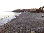
Seagrove Bay
Encyclopedia
Isle of Wight
The Isle of Wight is a county and the largest island of England, located in the English Channel, on average about 2–4 miles off the south coast of the county of Hampshire, separated from the mainland by a strait called the Solent...
, England
England
England is a country that is part of the United Kingdom. It shares land borders with Scotland to the north and Wales to the west; the Irish Sea is to the north west, the Celtic Sea to the south west, with the North Sea to the east and the English Channel to the south separating it from continental...
. It lies to the east of the village of Seaview
Seaview
- Places:* Seaview, Victoria, Australia, locality in Gippsland, Victoria, Australia* Seaview, Canterbury, a suburb of Timaru, New Zealand* Seaview, Clifton beach, a beach in Karachi* Seaview, Isle of Wight, a small village in England...
. It faces east towards Selsey Bill
Selsey Bill
Selsey Bill is a headland into the English Channel on the south coast of England in the county of West Sussex.The southern most town in Sussex is Selsey which is at the end of the Selsey Peninsula and Selsey Bill is situated on the towns southerncoastline...
and its shoreline is 1 km in length. It stretches from Nettlestone Point in the north to Horestone Point in the south.
Roughly at the centre is a public slipway
Slipway
A slipway, boat slip or just a slip, is a ramp on the shore by which ships or boats can be moved to and from the water. They are used for building and repairing ships and boats. They are also used for launching and retrieving small boats on trailers and flying boats on their undercarriage. The...
. To the south of the slipway is a curved concrete seawall
Seawall
A seawall is a form of coastal defence constructed where the sea, and associated coastal processes, impact directly upon the landforms of the coast. The purpose of a seawall is to protect areas of human habitation, conservation and leisure activities from the action of tides and waves...
protecting the shoreline, properties and boat houses. In addition there are four 30m groynes made of rock piles running out perpendicularly from the seawall into the bay. Each one has a post with a red can marking its seaward end. The beach between the groynes is predominantly sand but is completely covered at high water.
At the southernmost end of the bay is a wooden walkway
Walkway
In US English, a walkway is a composite or umbrella term for all engineered surfaces or structures which support the use of trails. These include sidewalks, footbridges, stiles, stairs, ramps, paseos or tunnels...
which give access from the end of the seawall to Horestone Point and Priory Bay
Priory Bay
Priory Bay is a small privately owned bay on the north east coast of the Isle of Wight, England. It lies to the east of the village of Nettlestone. It faces east towards Selsey Bill and its shoreline is 600m in length. It stretches from Horestone Point in the north to Nodes Point in the south.The...
beyond even during the high tide.
To the north of the slipway is a straight peeble beach. Further coastal protection measures are planned for this section if they can be justified environmentally and financially.
The sea bottom is sandy and gently shallowing. There are many shallow private mooring buoys out in the bay.