
Kearny County, Kansas
Encyclopedia
Kearny County is a county located in Southwest Kansas
, in the Central
United States
. As of the 2010 census, the county population was 3,977. Its county seat
and most populous city is Lakin
. The county is named in honor of General Philip Kearny
.
and Finney
counties. It was reestablished with its original borders in 1887, and organized on March 27, 1888. The county is named in honor of Philip Kearny
, a U.S. Army
officer in the Mexican–American War
and a Union army
general in the American Civil War
. In 1889, the name was corrected to Kearny County.
Kearny County observed Mountain Standard Time until the late 1980s, when the United States Department of Commerce
moved the county into the Central Time Zone, which 100 of the state's other 104 counties observe. Only four counties (Hamilton, Greeley, Wallace, and Sherman), all of which border Colorado
, observe Mountain Time.
, county until 1988, when voters approved the sale of alcoholic liquor by the individual drink with a 30% food sales requirement.
 As of the U.S. Census in 2000
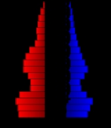
, there were 4,531 people, 1,542 households, and 1,199 families residing in the county. The population density
was 5 people per square mile (2/km²). There were 1,657 housing units at an average density of 2 per square mile (1/km²). The racial makeup
of the county was 80.34% White
, 0.55% Black or African American
, 0.86% Native American
, 0.31% Asian
, 0.09% Pacific Islander
, 15.71% from other races, and 2.14% from two or more races
. Hispanic
or Latino
of any race were 26.55% of the population.
There were 1,542 household
s out of which 43.50% had children under the age of 18 living with them, 65.10% were married couples
living together, 8.30% had a female householder with no husband present, and 22.20% were non-families. 20.20% of all households were made up of individuals and 8.50% had someone living alone who was 65 years of age or older. The average household size was 2.91 and the average family size was 3.35.
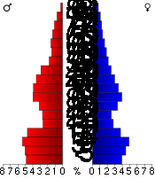
In the county the population was spread out with 34.30% under the age of 18, 8.30% from 18 to 24, 27.10% from 25 to 44, 19.20% from 45 to 64, and 11.10% who were 65 years of age or older. The median age was 32 years. For every 100 females there were 104.70 males. For every 100 females age 18 and over, there were 98.50 males.
The median income for a household
in the county was $40,149, and the median income for a family was $43,703. Males had a median income of $30,117 versus $20,179 for females. The per capita income
for the county was $15,708. About 8.40% of families and 11.70% of the population were below the poverty line, including 15.90% of those under age 18 and 4.80% of those age 65 or over.
. None of the cities within the county are considered governmentally independent, and all figures for the townships include those of the cities. In the following table, the population center is the largest city (or cities) included in that township's population total, if it is of a significant size.
Additional information
Maps
Kansas
Kansas is a US state located in the Midwestern United States. It is named after the Kansas River which flows through it, which in turn was named after the Kansa Native American tribe, which inhabited the area. The tribe's name is often said to mean "people of the wind" or "people of the south...
, in the Central
Central United States
The Central United States is sometimes conceived as between the Eastern United States and Western United States as part of a three-region model, roughly coincident with the Midwestern United States plus the western and central portions of the Southern United States; the term is also sometimes used...
United States
United States
The United States of America is a federal constitutional republic comprising fifty states and a federal district...
. As of the 2010 census, the county population was 3,977. Its county seat
County seat
A county seat is an administrative center, or seat of government, for a county or civil parish. The term is primarily used in the United States....
and most populous city is Lakin
Lakin, Kansas
Lakin is a city in and the county seat of Kearny County, Kansas, United States. As of the 2010 census, the city population was 2,216.-History:The city of Lakin is named after David Long Lakin, former treasurer of the Atchison, Topeka and Santa Fe Railway....
. The county is named in honor of General Philip Kearny
Philip Kearny
Philip Kearny, Jr., was a United States Army officer, notable for his leadership in the Mexican-American War and American Civil War. He was killed in action in the 1862 Battle of Chantilly.-Early life and career:...
.
History
The original Kearney County was established on March 6, 1873 and was dissolved in 1883, with the land area being split between HamiltonHamilton County, Kansas
Hamilton County is a county located in Southwest Kansas, in the Central United States. As of the 2010 census, the county population was 2,690...
and Finney
Finney County, Kansas
Finney County is a county located in Southwest Kansas, in the Central United States. As of the 2010 census, the county population was 36,776. Its county seat and most populous city is Garden City...
counties. It was reestablished with its original borders in 1887, and organized on March 27, 1888. The county is named in honor of Philip Kearny
Philip Kearny
Philip Kearny, Jr., was a United States Army officer, notable for his leadership in the Mexican-American War and American Civil War. He was killed in action in the 1862 Battle of Chantilly.-Early life and career:...
, a U.S. Army
United States Army
The United States Army is the main branch of the United States Armed Forces responsible for land-based military operations. It is the largest and oldest established branch of the U.S. military, and is one of seven U.S. uniformed services...
officer in the Mexican–American War
Mexican–American War
The Mexican–American War, also known as the First American Intervention, the Mexican War, or the U.S.–Mexican War, was an armed conflict between the United States and Mexico from 1846 to 1848 in the wake of the 1845 U.S...
and a Union army
Union Army
The Union Army was the land force that fought for the Union during the American Civil War. It was also known as the Federal Army, the U.S. Army, the Northern Army and the National Army...
general in the American Civil War
American Civil War
The American Civil War was a civil war fought in the United States of America. In response to the election of Abraham Lincoln as President of the United States, 11 southern slave states declared their secession from the United States and formed the Confederate States of America ; the other 25...
. In 1889, the name was corrected to Kearny County.
Kearny County observed Mountain Standard Time until the late 1980s, when the United States Department of Commerce
United States Department of Commerce
The United States Department of Commerce is the Cabinet department of the United States government concerned with promoting economic growth. It was originally created as the United States Department of Commerce and Labor on February 14, 1903...
moved the county into the Central Time Zone, which 100 of the state's other 104 counties observe. Only four counties (Hamilton, Greeley, Wallace, and Sherman), all of which border Colorado
Colorado
Colorado is a U.S. state that encompasses much of the Rocky Mountains as well as the northeastern portion of the Colorado Plateau and the western edge of the Great Plains...
, observe Mountain Time.
Law and government
Following amendment to the Kansas Constitution in 1986, the county remained a prohibition, or "dry"Dry county
A dry county is a county in the United States whose government forbids the sale of alcoholic beverages. Some prohibit off-premises sale, some prohibit on-premises sale, and some prohibit both. Hundreds of dry counties exist across the United States, almost all of them in the South...
, county until 1988, when voters approved the sale of alcoholic liquor by the individual drink with a 30% food sales requirement.
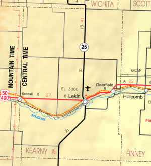
Geography
According to the 2000 census, the county has a total area of 871.5 square miles (2,257.2 km²), of which 871.06 square miles (2,256 km²) (or 99.95%) is land and 0.44 square miles (1.1 km²) (or 0.05%) is water.Adjacent counties
- Wichita CountyWichita County, KansasWichita County is a county located in the U.S. state of Kansas. As of the 2010 census, the county population was 2,234...
(north) - Scott CountyScott County, KansasScott County is a county located in the U.S. state of Kansas. As of the 2010 census, the county population was 4,936...
(northeast) - Finney CountyFinney County, KansasFinney County is a county located in Southwest Kansas, in the Central United States. As of the 2010 census, the county population was 36,776. Its county seat and most populous city is Garden City...
(east) - Haskell CountyHaskell County, KansasHaskell County is a county located in Southwest Kansas, in the Central United States. As of the 2010 census, the county population was 4,256...
(southeast) - Grant CountyGrant County, KansasGrant County is a county located in southwest Kansas, in the Central United States. As of the 2010 census, the county population was 7,829...
(south) - Stanton CountyStanton County, KansasStanton County is a county located in the U.S. state of Kansas. As of the 2010 census, the county population was 2,235...
(southwest) - Hamilton CountyHamilton County, KansasHamilton County is a county located in Southwest Kansas, in the Central United States. As of the 2010 census, the county population was 2,690...
(west)
Demographics
United States Census, 2000
The Twenty-second United States Census, known as Census 2000 and conducted by the Census Bureau, determined the resident population of the United States on April 1, 2000, to be 281,421,906, an increase of 13.2% over the 248,709,873 persons enumerated during the 1990 Census...
, there were 4,531 people, 1,542 households, and 1,199 families residing in the county. The population density
Population density
Population density is a measurement of population per unit area or unit volume. It is frequently applied to living organisms, and particularly to humans...
was 5 people per square mile (2/km²). There were 1,657 housing units at an average density of 2 per square mile (1/km²). The racial makeup
Race (United States Census)
Race and ethnicity in the United States Census, as defined by the Federal Office of Management and Budget and the United States Census Bureau, are self-identification data items in which residents choose the race or races with which they most closely identify, and indicate whether or not they are...
of the county was 80.34% White
White American
White Americans are people of the United States who are considered or consider themselves White. The United States Census Bureau defines White people as those "having origins in any of the original peoples of Europe, the Middle East, or North Africa...
, 0.55% Black or African American
African American
African Americans are citizens or residents of the United States who have at least partial ancestry from any of the native populations of Sub-Saharan Africa and are the direct descendants of enslaved Africans within the boundaries of the present United States...
, 0.86% Native American
Native Americans in the United States
Native Americans in the United States are the indigenous peoples in North America within the boundaries of the present-day continental United States, parts of Alaska, and the island state of Hawaii. They are composed of numerous, distinct tribes, states, and ethnic groups, many of which survive as...
, 0.31% Asian
Asian American
Asian Americans are Americans of Asian descent. The U.S. Census Bureau definition of Asians as "Asian” refers to a person having origins in any of the original peoples of the Far East, Southeast Asia, or the Indian subcontinent, including, for example, Cambodia, China, India, Indonesia, Japan,...
, 0.09% Pacific Islander
Pacific Islander American
Pacific Islander Americans, also known as Oceanian Americans, are residents of the United States with original ancestry from Oceania. They represent the smallest racial group counted in the United States census of 2000. They numbered 874,000 people or 0.3 percent of the United States population...
, 15.71% from other races, and 2.14% from two or more races
Multiracial
The terms multiracial and mixed-race describe people whose ancestries come from multiple races. Unlike the term biracial, which often is only used to refer to having parents or grandparents of two different races, the term multiracial may encompass biracial people but can also include people with...
. Hispanic
Hispanic
Hispanic is a term that originally denoted a relationship to Hispania, which is to say the Iberian Peninsula: Andorra, Gibraltar, Portugal and Spain. During the Modern Era, Hispanic sometimes takes on a more limited meaning, particularly in the United States, where the term means a person of ...
or Latino
Latino
The demonyms Latino and Latina , are defined in English language dictionaries as:* "a person of Latin-American descent."* "A Latin American."* "A person of Hispanic, especially Latin-American, descent, often one living in the United States."...
of any race were 26.55% of the population.
There were 1,542 household
Household
The household is "the basic residential unit in which economic production, consumption, inheritance, child rearing, and shelter are organized and carried out"; [the household] "may or may not be synonymous with family"....
s out of which 43.50% had children under the age of 18 living with them, 65.10% were married couples
Marriage
Marriage is a social union or legal contract between people that creates kinship. It is an institution in which interpersonal relationships, usually intimate and sexual, are acknowledged in a variety of ways, depending on the culture or subculture in which it is found...
living together, 8.30% had a female householder with no husband present, and 22.20% were non-families. 20.20% of all households were made up of individuals and 8.50% had someone living alone who was 65 years of age or older. The average household size was 2.91 and the average family size was 3.35.
In the county the population was spread out with 34.30% under the age of 18, 8.30% from 18 to 24, 27.10% from 25 to 44, 19.20% from 45 to 64, and 11.10% who were 65 years of age or older. The median age was 32 years. For every 100 females there were 104.70 males. For every 100 females age 18 and over, there were 98.50 males.
The median income for a household
Median household income
The median household income is commonly used to generate data about geographic areas and divides households into two equal segments with the first half of households earning less than the median household income and the other half earning more...
in the county was $40,149, and the median income for a family was $43,703. Males had a median income of $30,117 versus $20,179 for females. The per capita income
Per capita income
Per capita income or income per person is a measure of mean income within an economic aggregate, such as a country or city. It is calculated by taking a measure of all sources of income in the aggregate and dividing it by the total population...
for the county was $15,708. About 8.40% of families and 11.70% of the population were below the poverty line, including 15.90% of those under age 18 and 4.80% of those age 65 or over.
Incorporated cities
Name and population (2004 estimate):- LakinLakin, KansasLakin is a city in and the county seat of Kearny County, Kansas, United States. As of the 2010 census, the city population was 2,216.-History:The city of Lakin is named after David Long Lakin, former treasurer of the Atchison, Topeka and Santa Fe Railway....
, 2,303 (county seat) - DeerfieldDeerfield, KansasDeerfield is a city in Kearny County, Kansas, United States. As of the 2010 census, the city population was 700.-Geography:Deerfield is located at . According to the United States Census Bureau, the city has a total area of , all of it land.-Demographics:As of the census of 2000, there were 884...
, 879
Townships
Kearny County is divided into seven townshipsCivil township
A civil township is a widely used unit of local government in the United States, subordinate to, and geographic divisions of, a county. Specific responsibilities and the degree of autonomy vary based on each state. Civil townships are distinct from survey townships, but in states that have both,...
. None of the cities within the county are considered governmentally independent, and all figures for the townships include those of the cities. In the following table, the population center is the largest city (or cities) included in that township's population total, if it is of a significant size.
| Township | FIPS | Population center |
Population | Population density /km² (/sq mi) |
Land area km² (sq mi) | Water area km² (sq mi) | Water % | Geographic coordinates |
|---|---|---|---|---|---|---|---|---|
| Deerfield | 17250 | 1,104 | 9 (24) | 120 (46) | 1 (0) | 0.66% | 38°0′30"N 101°8′55"W | |
| East Hibbard | 19550 | 131 | 0 (1) | 403 (156) | 0 (0) | 0 % | 38°9′19"N 101°12′14"W | |
| Hartland | 30500 | 128 | 0 (1) | 388 (150) | 0 (0) | 0.03% | 38°0′44"N 101°24′49"W | |
| Kendall | 36450 | 157 | 0 (1) | 494 (191) | 0 (0) | 0 % | 37°46′56"N 101°18′32"W | |
| Lakin | 38200 | 2,587 | 16 (41) | 164 (63) | 0 (0) | 0.04% | 37°57′16"N 101°15′45"W | |
| Southside | 67025 | 359 | 1 (3) | 286 (110) | 0 (0) | 0.06% | 37°55′9"N 101°12′12"W | |
| West Hibbard | 77050 | 65 | 0 (0) | 402 (155) | 0 (0) | 0 % | 38°10′10"N 101°25′23"W | |
| Sources: | ||||||||
Education
Unified school districts
Further reading
- History of the State of Kansas; William G. Cutler; A.T. Andreas Publisher; 1883. (Online HTML eBook)
- Kansas : A Cyclopedia of State History, Embracing Events, Institutions, Industries, Counties, Cities, Towns, Prominent Persons, Etc; 3 Volumes; Frank W. Blackmar; Standard Publishing Co; 944 / 955 / 824 pages; 1912. (Volume1 - Download 54MB PDF eBook),(Volume2 - Download 53MB PDF eBook), (Volume3 - Download 33MB PDF eBook)
External links
Official sitesAdditional information
Maps
- Kearny County Map, KDOT
- Kansas Highway Map, KDOT
- Kansas Railroad Map, KDOT
- Kansas School District Boundary Map, KSDE