
Sawyer County, Wisconsin
Encyclopedia
Sawyer County is a county
in the U.S. state
of Wisconsin
. As of 2000, the population was 16,196. Its county seat
is Hayward
.
, who represented Wisconsin in the U.S. House of Representatives and U.S. Senate in the 19th century.
, the county has a total area of 1,350 square miles (3,497 km²), of which 1,256 square miles (3,254 km²) is land and 94 square miles (243 km²) (6.95%) is water.
Sawyer County Highway B is the busiest rural roadway on average in all of Sawyer County with a high count of 5900 vehicles daily, according to the Wisconsin Department of Transportation's average daily traffic maps for 2008. http://www.dot.wisconsin.gov/travel/counts/docs/sawyer/sawyer2008.pdf
National protected area
As of the census
of 2000, there were 16,196 people, 6,640 households, and 4,581 families residing in the county. The population density
was 13 people per square mile (5/km²). There were 13,722 housing units at an average density of 11 per square mile (4/km²). The racial makeup of the county was 81.72% White
, 0.31% Black
or African American
, 16.07% Native American
, 0.30% Asian
, 0.02% Pacific Islander
, 0.35% from other races
, and 1.23% from two or more races. 0.90% of the population were Hispanic
or Latino
of any race. 29.6% were of German, 7.8% Irish
, 6.7% Norwegian, 5.9% Polish, 5.2% Swedish and 5.2% English
ancestry according to Census 2000. 95.4% spoke English
, 2.0% Ojibwa and 1.1% Spanish
as their first language.
There were 6,640 households out of which 27.50% had children under the age of 18 living with them, 54.20% were married couples
living together, 10.00% had a female householder with no husband present, and 31.00% were non-families. 26.20% of all households were made up of individuals and 11.70% had someone living alone who was 65 years of age or older. The average household size was 2.39 and the average family size was 2.86.
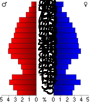
In the county, the population was spread out with 24.10% under the age of 18, 6.00% from 18 to 24, 24.60% from 25 to 44, 27.40% from 45 to 64, and 17.90% who were 65 years of age or older. The median age was 42 years. For every 100 females there were 101.80 males. For every 100 females age 18 and over, there were 101.00 males.
County (United States)
In the United States, a county is a geographic subdivision of a state , usually assigned some governmental authority. The term "county" is used in 48 of the 50 states; Louisiana is divided into parishes and Alaska into boroughs. Parishes and boroughs are called "county-equivalents" by the U.S...
in the U.S. state
U.S. state
A U.S. state is any one of the 50 federated states of the United States of America that share sovereignty with the federal government. Because of this shared sovereignty, an American is a citizen both of the federal entity and of his or her state of domicile. Four states use the official title of...
of Wisconsin
Wisconsin
Wisconsin is a U.S. state located in the north-central United States and is part of the Midwest. It is bordered by Minnesota to the west, Iowa to the southwest, Illinois to the south, Lake Michigan to the east, Michigan to the northeast, and Lake Superior to the north. Wisconsin's capital is...
. As of 2000, the population was 16,196. Its county seat
County seat
A county seat is an administrative center, or seat of government, for a county or civil parish. The term is primarily used in the United States....
is Hayward
Hayward, Wisconsin
Hayward is a city in Sawyer County, Wisconsin, United States, next to the Namekagon River. The population was 2,129 at the 2000 census. The city is surrounded by the Town of Hayward.-Transportation:U.S...
.
History
The county is named for Philetus SawyerPhiletus Sawyer
Philetus Sawyer was an American politician of the Republican Party who represented Wisconsin in both houses of Congress. Sawyer County, Wisconsin, is named for him....
, who represented Wisconsin in the U.S. House of Representatives and U.S. Senate in the 19th century.
Geography
According to the U.S. Census BureauUnited States Census Bureau
The United States Census Bureau is the government agency that is responsible for the United States Census. It also gathers other national demographic and economic data...
, the county has a total area of 1,350 square miles (3,497 km²), of which 1,256 square miles (3,254 km²) is land and 94 square miles (243 km²) (6.95%) is water.
Adjacent counties
- Bayfield County - north
- Ashland County - northeast
- Price CountyPrice County, WisconsinPrice County is a county in the U.S. state of Wisconsin. As of 2000, the population was 15,822. Its county seat is Phillips.-Geography:According to the U.S. Census Bureau, the county has a total area of , of which is land and is water...
- east - Rusk CountyRusk County, WisconsinRusk County is a county in the U.S. state of Wisconsin. As of 2000, the population was 15,347. Its county seat is Ladysmith. Founded in 1901, Rusk County was originally named "Gates" County. It was formed out of the northern portion of Chippewa County....
- south - Barron County - southwest
- Washburn CountyWashburn County, WisconsinWashburn County is a county in the U.S. state of Wisconsin. As of 2000, the population was 16,036. Its county seat is Shell Lake.-Geography:According to the U.S...
- west - Douglas County - northwest
Major highways
|
 Highway 48 (Wisconsin) Highway 48 (Wisconsin)Highway 48 (Wisconsin) State Trunk Highway 48 is a state highway in the U.S. state of Wisconsin. It runs east–west in northwest Wisconsin from Grantsburg to Exeland....  Highway 70 (Wisconsin) Highway 70 (Wisconsin)Highway 70 (Wisconsin) State Trunk Highway 70 is a state highway in the U.S. state of Wisconsin. It runs east–west in northern Wisconsin from a shared terminus with WIS 101 at US 2 and US 141 near Florence to a connection with Minnesota State Highway 70 at the St. Croix River west of Grantsburg in Burnett County...  Highway 77 (Wisconsin) Highway 77 (Wisconsin)Highway 77 (Wisconsin) State Trunk Highway 77 is a state highway in the U.S. state of Wisconsin. It runs east–west in northwest Wisconsin from the Michigan border in Hurley to the Minnesota border near Danbury.... |
 U.S. Highway 63

National protected areaProtected areaProtected areas are locations which receive protection because of their recognised natural, ecological and/or cultural values. There are several kinds of protected areas, which vary by level of protection depending on the enabling laws of each country or the regulations of the international...
s
- Chequamegon National Forest (part)
- Saint Croix National Scenic RiverwaySaint Croix National Scenic RiverwayThe Saint Croix National Scenic Riverway is a federally protected system of riverways located in eastern Minnesota and northwestern Wisconsin. It protects of river, including the St. Croix River , and the Namekagon River , as well as adjacent land along the rivers. The St...
(part)
Demographics
As of the census
Census
A census is the procedure of systematically acquiring and recording information about the members of a given population. It is a regularly occurring and official count of a particular population. The term is used mostly in connection with national population and housing censuses; other common...
of 2000, there were 16,196 people, 6,640 households, and 4,581 families residing in the county. The population density
Population density
Population density is a measurement of population per unit area or unit volume. It is frequently applied to living organisms, and particularly to humans...
was 13 people per square mile (5/km²). There were 13,722 housing units at an average density of 11 per square mile (4/km²). The racial makeup of the county was 81.72% White
Race (United States Census)
Race and ethnicity in the United States Census, as defined by the Federal Office of Management and Budget and the United States Census Bureau, are self-identification data items in which residents choose the race or races with which they most closely identify, and indicate whether or not they are...
, 0.31% Black
Race (United States Census)
Race and ethnicity in the United States Census, as defined by the Federal Office of Management and Budget and the United States Census Bureau, are self-identification data items in which residents choose the race or races with which they most closely identify, and indicate whether or not they are...
or African American
Race (United States Census)
Race and ethnicity in the United States Census, as defined by the Federal Office of Management and Budget and the United States Census Bureau, are self-identification data items in which residents choose the race or races with which they most closely identify, and indicate whether or not they are...
, 16.07% Native American
Race (United States Census)
Race and ethnicity in the United States Census, as defined by the Federal Office of Management and Budget and the United States Census Bureau, are self-identification data items in which residents choose the race or races with which they most closely identify, and indicate whether or not they are...
, 0.30% Asian
Race (United States Census)
Race and ethnicity in the United States Census, as defined by the Federal Office of Management and Budget and the United States Census Bureau, are self-identification data items in which residents choose the race or races with which they most closely identify, and indicate whether or not they are...
, 0.02% Pacific Islander
Race (United States Census)
Race and ethnicity in the United States Census, as defined by the Federal Office of Management and Budget and the United States Census Bureau, are self-identification data items in which residents choose the race or races with which they most closely identify, and indicate whether or not they are...
, 0.35% from other races
Race (United States Census)
Race and ethnicity in the United States Census, as defined by the Federal Office of Management and Budget and the United States Census Bureau, are self-identification data items in which residents choose the race or races with which they most closely identify, and indicate whether or not they are...
, and 1.23% from two or more races. 0.90% of the population were Hispanic
Race (United States Census)
Race and ethnicity in the United States Census, as defined by the Federal Office of Management and Budget and the United States Census Bureau, are self-identification data items in which residents choose the race or races with which they most closely identify, and indicate whether or not they are...
or Latino
Race (United States Census)
Race and ethnicity in the United States Census, as defined by the Federal Office of Management and Budget and the United States Census Bureau, are self-identification data items in which residents choose the race or races with which they most closely identify, and indicate whether or not they are...
of any race. 29.6% were of German, 7.8% Irish
Irish people
The Irish people are an ethnic group who originate in Ireland, an island in northwestern Europe. Ireland has been populated for around 9,000 years , with the Irish people's earliest ancestors recorded having legends of being descended from groups such as the Nemedians, Fomorians, Fir Bolg, Tuatha...
, 6.7% Norwegian, 5.9% Polish, 5.2% Swedish and 5.2% English
English people
The English are a nation and ethnic group native to England, who speak English. The English identity is of early mediaeval origin, when they were known in Old English as the Anglecynn. England is now a country of the United Kingdom, and the majority of English people in England are British Citizens...
ancestry according to Census 2000. 95.4% spoke English
English language
English is a West Germanic language that arose in the Anglo-Saxon kingdoms of England and spread into what was to become south-east Scotland under the influence of the Anglian medieval kingdom of Northumbria...
, 2.0% Ojibwa and 1.1% Spanish
Spanish language
Spanish , also known as Castilian , is a Romance language in the Ibero-Romance group that evolved from several languages and dialects in central-northern Iberia around the 9th century and gradually spread with the expansion of the Kingdom of Castile into central and southern Iberia during the...
as their first language.
There were 6,640 households out of which 27.50% had children under the age of 18 living with them, 54.20% were married couples
Marriage
Marriage is a social union or legal contract between people that creates kinship. It is an institution in which interpersonal relationships, usually intimate and sexual, are acknowledged in a variety of ways, depending on the culture or subculture in which it is found...
living together, 10.00% had a female householder with no husband present, and 31.00% were non-families. 26.20% of all households were made up of individuals and 11.70% had someone living alone who was 65 years of age or older. The average household size was 2.39 and the average family size was 2.86.
In the county, the population was spread out with 24.10% under the age of 18, 6.00% from 18 to 24, 24.60% from 25 to 44, 27.40% from 45 to 64, and 17.90% who were 65 years of age or older. The median age was 42 years. For every 100 females there were 101.80 males. For every 100 females age 18 and over, there were 101.00 males.
Villages
- CouderayCouderay, WisconsinCouderay is a village in Sawyer County, Wisconsin, United States, along the Couderay River. The population was 96 at the 2000 census. The village is located within the Town of Couderay....
- ExelandExeland, WisconsinExeland is a village in Sawyer County, Wisconsin, United States. The population was 212 at the 2000 census.-Geography:Exeland is located at ....
- RadissonRadisson, WisconsinRadisson is a village in Sawyer County, Wisconsin, United States, along the Couderay River. The population was 222 at the 2000 census. The village is located within the Town of Radisson and was named in honor of the early French explorer, Pierre-Esprit Radisson .-Geography:Radisson is located at ...
- WinterWinter, WisconsinWinter is a village in Sawyer County, Wisconsin, United States. The population was 233 at the 2010 census. The village is within the Town of Winter.-Geography:Winter is located at ....
Towns
- Bass LakeBass Lake, Sawyer County, WisconsinBass Lake is a town in Sawyer County, Wisconsin, United States. The population was 2,244 at the 2000 census. The unincorporated community of Northwoods Beach is located in the town.-Geography:...
- Couderay (town)Couderay (town), WisconsinCouderay is a town in Sawyer County, Wisconsin, United States. The population was 469 at the 2000 census. The Village of Couderay is located within the town...
- DraperDraper, WisconsinDraper is a town in Sawyer County, Wisconsin, United States. The population was 171 at the 2000 census. The unincorporated communities of Draper, Loretta, and Oxbo are located in the town.-Geography:...
- EdgewaterEdgewater, WisconsinEdgewater is a town in Sawyer County, Wisconsin, United States. The population was 586 at the 2000 census. The unincorporated community of Edgewater is located in the town...
- Hayward (town)Hayward (town), WisconsinHayward is a town in Sawyer County, Wisconsin, United States. The population was 3,279 at the 2000 census. The town is located near the City of Hayward.U.S...
- HunterHunter, WisconsinHunter is a town in Sawyer County, Wisconsin, United States. The population was 765 at the 2000 census.-Geography:According to the United States Census Bureau, the town has a total area of 76.0 square miles , of which, 52.1 square miles of it is land and 23.9 square miles of it is...
- LenrootLenroot, WisconsinLenroot is a town in Sawyer County, Wisconsin, United States. The population was 1,165 at the 2000 census. The unincorporated community of Seeley is located in the town.-Geography:...
- MeadowbrookMeadowbrook, WisconsinMeadowbrook is a town in Sawyer County, Wisconsin, United States. The population was 146 at the 2000 census.-Geography:According to the United States Census Bureau, the town has a total area of 36.2 square miles , of which, 36.0 square miles of it is land and 0.3 square miles of it...
- MeteorMeteor, WisconsinMeteor is a town in Sawyer County, Wisconsin, United States. The population was 170 at the 2000 census.-Geography:According to the United States Census Bureau, the town has a total area of 35.2 square miles , of which, 34.4 square miles of it is land and 0.8 square miles of it is...
- OjibwaOjibwa, WisconsinOjibwa is a town in Sawyer County, Wisconsin, United States. The population was 267 at the 2000 census. The unincorporated community of Ojibwa is located in the town.-Geography:...
- Radisson (town)Radisson (town), WisconsinRadisson is a town in Sawyer County, Wisconsin, United States. The population was 465 at the 2000 census. The Village of Radisson is located within the town.-Geography:...
- Round LakeRound Lake, WisconsinRound Lake is a town in Sawyer County, Wisconsin, United States. The population was 962 at the 2000 census.-Geography:According to the United States Census Bureau, the town has a total area of 118.2 square miles , of which, 109.3 square miles of it is land and 8.9 square miles of...
- Sand LakeSand Lake, Sawyer County, WisconsinSand Lake is a town in Sawyer County, Wisconsin, United States. The population was 774 at the 2000 census. The census-designated place of Stone Lake is located partially in the town.-Geography:...
- Spider LakeSpider Lake, WisconsinSpider Lake is a town in Sawyer County, Wisconsin, United States. The population was 391 at the 2000 census.-Geography:According to the United States Census Bureau, the town has a total area of 108.9 square miles , of which, 99.2 square miles of it is land and 9.6 square miles of...
- WeirgorWeirgor, WisconsinWeirgor is a town in Sawyer County, Wisconsin, United States. The population was 370 at the 2000 census.-Geography:According to the United States Census Bureau, the town has a total area of 34.4 square miles , of which, 33.5 square miles of it is land and 0.9 square miles of it is...
- Winter (town)Winter (town), WisconsinWinter is a town in Sawyer County, Wisconsin, United States. The population was 969 at the 2000 census. The Village of Winter is located within the town, but not a part of it.-Geography:...
Unincorporated communities
- Chief LakeChief Lake, WisconsinChief Lake is a census-designated place in Sawyer County, Wisconsin, United States. The population was 583 at the 2010 census.-Geography:Chief Lake is located at ....
- DraperDraper (community), WisconsinDraper is an unincorporated community in the town of Draper, Sawyer County, Wisconsin, United States. Draper is located on Wisconsin Highway 70 northeast of Winter....
- EdgewaterEdgewater (community), WisconsinEdgewater is an unincorporated community located in the town of Edgewater, Sawyer County, Wisconsin, United States. Edgewater is located along County Highway F on the northern shore of Lake Chetac, west-southwest of Couderay. Edgewater had a post office, which closed on October 21, 1995....
- Little Round LakeLittle Round Lake, WisconsinLittle Round Lake is a census-designated place in Sawyer County, Wisconsin, United States. The population was 1,081 at the 2010 census.-Geography:Little Round Lake is located at ....
- LorettaLoretta, WisconsinLoretta is an unincorporated community in the town of Draper, Sawyer County, Wisconsin, United States. Loretta is located on Wisconsin Highway 70 northeast of Winter....
- New PostNew Post, WisconsinNew Post is a census-designated place in Sawyer County, Wisconsin, United States. The population was 305 at the 2010 census.-Geography:New Post is located at ....
- Northwoods BeachNorthwoods Beach, WisconsinNorthwoods Beach is an unincorporated community in the town of Bass Lake, Sawyer County, Wisconsin, United States. Northwoods Beach is located on an isthmus between Grindstone Lake and Lac Courte Oreilles, south-southeast of Hayward....
- OjibwaOjibwa (community), WisconsinOjibwa is an unincorporated community located in the town of Ojibwa, Sawyer County, Wisconsin, United States. Ojibwa is located on the Chippewa River at the junction of Wisconsin Highway 27 and Wisconsin Highway 70, east of Radisson and west-southwest of Winter. Ojibwa had a post office, which...
- OxboOxbo, WisconsinOxbo is an unincorporated community in the town of Draper, Sawyer County, Wisconsin, United States. Oxbo is located on the Flambeau River and Wisconsin Highway 70 west-southwest of Park Falls....
- ReserveReserve, WisconsinReserve is a census-designated place in Sawyer County, Wisconsin, United States. The population was 429 at the 2010 census.-Geography:Reserve is located at ....
- SeeleySeeley, WisconsinSeeley is an unincorporated community located in the town of Lenroot, Sawyer County, Wisconsin, United States....
- Stone LakeStone Lake (community), WisconsinStone Lake is an unincorporated census-designated place in Sawyer and Washburn counties, Wisconsin, United States. Stone Lake is located on the eastern shore of Stone Lake and along Wisconsin Highway 70, west-northwest of Couderay. The Sawyer County portion of the community is located in the town...
(partial) - YarnellYarnell, WisconsinYarnell is an unincorporated community in the towns of Couderay and Edgewater, Sawyer County, Wisconsin, United States. Yarnell is southwest of the village of Couderay....
See also
- National Register of Historic Places listings in Sawyer County, Wisconsin