

Rusk County, Wisconsin
Encyclopedia
Rusk County is a county
in the U.S. state
of Wisconsin
. As of 2000, the population was 15,347. Its county seat
is Ladysmith
. Founded in 1901, Rusk County was originally named "Gates" County. It was formed out of the northern portion of Chippewa County
.
, the county has a total area of 931 square miles (2,411.3 km²), of which 913 square miles (2,364.7 km²) is land and 18 square miles (46.6 km²) (1.91%) is water.
As of the census
of 2000, there were 15,347 people, 6,095 households, and 4,156 families residing in the county. The population density
was 17 people per square mile (6/km²). There were 7,609 housing units at an average density of 8 per square mile (3/km²). The racial makeup of the county was 97.69% White
, 0.51% Black
or African American
, 0.42% Native American
, 0.26% Asian
, 0.10% Pacific Islander
, 0.35% from other races
, and 0.66% from two or more races. 0.76% of the population were Hispanic
or Latino
of any race. 32.7% were of German, 13.6% Polish, 9.0% Norwegian, 6.8% Irish
, 6.2% American
and 5.6% English
ancestry according to Census 2000.
There were 6,095 households out of which 28.60% had children under the age of 18 living with them, 55.90% were married couples
living together, 7.90% had a female householder with no husband present, and 31.80% were non-families. 27.00% of all households were made up of individuals and 14.30% had someone living alone who was 65 years of age or older. The average household size was 2.45 and the average family size was 2.97.
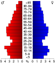
In the county, the population was spread out with 24.80% under the age of 18, 7.90% from 18 to 24, 24.80% from 25 to 44, 24.10% from 45 to 64, and 18.50% who were 65 years of age or older. The median age was 40 years. For every 100 females there were 98.50 males. For every 100 females age 18 and over, there were 97.40 males.
† Horseman was mainly in Rusk County, but extended into Barron County.
County (United States)
In the United States, a county is a geographic subdivision of a state , usually assigned some governmental authority. The term "county" is used in 48 of the 50 states; Louisiana is divided into parishes and Alaska into boroughs. Parishes and boroughs are called "county-equivalents" by the U.S...
in the U.S. state
U.S. state
A U.S. state is any one of the 50 federated states of the United States of America that share sovereignty with the federal government. Because of this shared sovereignty, an American is a citizen both of the federal entity and of his or her state of domicile. Four states use the official title of...
of Wisconsin
Wisconsin
Wisconsin is a U.S. state located in the north-central United States and is part of the Midwest. It is bordered by Minnesota to the west, Iowa to the southwest, Illinois to the south, Lake Michigan to the east, Michigan to the northeast, and Lake Superior to the north. Wisconsin's capital is...
. As of 2000, the population was 15,347. Its county seat
County seat
A county seat is an administrative center, or seat of government, for a county or civil parish. The term is primarily used in the United States....
is Ladysmith
Ladysmith, Wisconsin
Ladysmith is a city in Rusk County, Wisconsin, United States. The population was 3,932 at the 2000 census. It is the county seat of Rusk County. It is the former location of Mount Senario College, which closed in 2002 due to significant debt. For the 2006-2007 school year, part of the former campus...
. Founded in 1901, Rusk County was originally named "Gates" County. It was formed out of the northern portion of Chippewa County
Chippewa County, Wisconsin
Chippewa County is a county located in the U.S. state of Wisconsin. As of 2000, the population was 55,195. Its county seat is Chippewa Falls. The United States Census Bureau's Eau Claire Metropolitan Statistical Area includes all of Chippewa County...
.
Geography
According to the U.S. Census BureauUnited States Census Bureau
The United States Census Bureau is the government agency that is responsible for the United States Census. It also gathers other national demographic and economic data...
, the county has a total area of 931 square miles (2,411.3 km²), of which 913 square miles (2,364.7 km²) is land and 18 square miles (46.6 km²) (1.91%) is water.
Adjacent counties
- Sawyer CountySawyer County, WisconsinSawyer County is a county in the U.S. state of Wisconsin. As of 2000, the population was 16,196. Its county seat is Hayward.-History:The county is named for Philetus Sawyer, who represented Wisconsin in the U.S. House of Representatives and U.S. Senate in the 19th century.-Geography:According to...
- north - Price CountyPrice County, WisconsinPrice County is a county in the U.S. state of Wisconsin. As of 2000, the population was 15,822. Its county seat is Phillips.-Geography:According to the U.S. Census Bureau, the county has a total area of , of which is land and is water...
- east - Taylor CountyTaylor County, WisconsinTaylor County is a county in the U.S. state of Wisconsin. As of 2010, the population was 20,689. Its county seat is Medford.-History:The earliest recorded event in Taylor county probably occurred in 1661, when Wisconsin was part of New France...
- southeast - Chippewa CountyChippewa County, WisconsinChippewa County is a county located in the U.S. state of Wisconsin. As of 2000, the population was 55,195. Its county seat is Chippewa Falls. The United States Census Bureau's Eau Claire Metropolitan Statistical Area includes all of Chippewa County...
- south - Barron County - west
- Washburn CountyWashburn County, WisconsinWashburn County is a county in the U.S. state of Wisconsin. As of 2000, the population was 16,036. Its county seat is Shell Lake.-Geography:According to the U.S...
- northwest
Major highways
|
 U.S. Highway 8


Demographics
As of the census
Census
A census is the procedure of systematically acquiring and recording information about the members of a given population. It is a regularly occurring and official count of a particular population. The term is used mostly in connection with national population and housing censuses; other common...
of 2000, there were 15,347 people, 6,095 households, and 4,156 families residing in the county. The population density
Population density
Population density is a measurement of population per unit area or unit volume. It is frequently applied to living organisms, and particularly to humans...
was 17 people per square mile (6/km²). There were 7,609 housing units at an average density of 8 per square mile (3/km²). The racial makeup of the county was 97.69% White
Race (United States Census)
Race and ethnicity in the United States Census, as defined by the Federal Office of Management and Budget and the United States Census Bureau, are self-identification data items in which residents choose the race or races with which they most closely identify, and indicate whether or not they are...
, 0.51% Black
Race (United States Census)
Race and ethnicity in the United States Census, as defined by the Federal Office of Management and Budget and the United States Census Bureau, are self-identification data items in which residents choose the race or races with which they most closely identify, and indicate whether or not they are...
or African American
Race (United States Census)
Race and ethnicity in the United States Census, as defined by the Federal Office of Management and Budget and the United States Census Bureau, are self-identification data items in which residents choose the race or races with which they most closely identify, and indicate whether or not they are...
, 0.42% Native American
Race (United States Census)
Race and ethnicity in the United States Census, as defined by the Federal Office of Management and Budget and the United States Census Bureau, are self-identification data items in which residents choose the race or races with which they most closely identify, and indicate whether or not they are...
, 0.26% Asian
Race (United States Census)
Race and ethnicity in the United States Census, as defined by the Federal Office of Management and Budget and the United States Census Bureau, are self-identification data items in which residents choose the race or races with which they most closely identify, and indicate whether or not they are...
, 0.10% Pacific Islander
Race (United States Census)
Race and ethnicity in the United States Census, as defined by the Federal Office of Management and Budget and the United States Census Bureau, are self-identification data items in which residents choose the race or races with which they most closely identify, and indicate whether or not they are...
, 0.35% from other races
Race (United States Census)
Race and ethnicity in the United States Census, as defined by the Federal Office of Management and Budget and the United States Census Bureau, are self-identification data items in which residents choose the race or races with which they most closely identify, and indicate whether or not they are...
, and 0.66% from two or more races. 0.76% of the population were Hispanic
Race (United States Census)
Race and ethnicity in the United States Census, as defined by the Federal Office of Management and Budget and the United States Census Bureau, are self-identification data items in which residents choose the race or races with which they most closely identify, and indicate whether or not they are...
or Latino
Race (United States Census)
Race and ethnicity in the United States Census, as defined by the Federal Office of Management and Budget and the United States Census Bureau, are self-identification data items in which residents choose the race or races with which they most closely identify, and indicate whether or not they are...
of any race. 32.7% were of German, 13.6% Polish, 9.0% Norwegian, 6.8% Irish
Irish people
The Irish people are an ethnic group who originate in Ireland, an island in northwestern Europe. Ireland has been populated for around 9,000 years , with the Irish people's earliest ancestors recorded having legends of being descended from groups such as the Nemedians, Fomorians, Fir Bolg, Tuatha...
, 6.2% American
United States
The United States of America is a federal constitutional republic comprising fifty states and a federal district...
and 5.6% English
English people
The English are a nation and ethnic group native to England, who speak English. The English identity is of early mediaeval origin, when they were known in Old English as the Anglecynn. England is now a country of the United Kingdom, and the majority of English people in England are British Citizens...
ancestry according to Census 2000.
There were 6,095 households out of which 28.60% had children under the age of 18 living with them, 55.90% were married couples
Marriage
Marriage is a social union or legal contract between people that creates kinship. It is an institution in which interpersonal relationships, usually intimate and sexual, are acknowledged in a variety of ways, depending on the culture or subculture in which it is found...
living together, 7.90% had a female householder with no husband present, and 31.80% were non-families. 27.00% of all households were made up of individuals and 14.30% had someone living alone who was 65 years of age or older. The average household size was 2.45 and the average family size was 2.97.
In the county, the population was spread out with 24.80% under the age of 18, 7.90% from 18 to 24, 24.80% from 25 to 44, 24.10% from 45 to 64, and 18.50% who were 65 years of age or older. The median age was 40 years. For every 100 females there were 98.50 males. For every 100 females age 18 and over, there were 97.40 males.
Cities, villages, and towns
| Cities and Villages |
Towns | Unincorporated Communities |
Ghost Towns | ||||||
|---|---|---|---|---|---|---|---|---|---|
|
Atlanta, Wisconsin Atlanta is a town in Rusk County, Wisconsin, United States. The population was 627 at the 2000 census. The unincorporated community of Imalone is located partially in the town.-Geography:... Big Bend, Rusk County, Wisconsin Big Bend is a town in Rusk County, Wisconsin, United States. The population was 402 at the 2000 census. The unincorporated community of Island Lake is located in the town.-Geography:... Big Falls, Rusk County, Wisconsin Big Falls is a town in Rusk County, Wisconsin, United States. The population was 107 at the 2000 census.-Geography:According to the United States Census Bureau, the town has a total area of 36.0 square miles , of which, 35.4 square miles of it is land and 0.6 square miles of it is... Cedar Rapids, Wisconsin Cedar Rapids is a town in Rusk County, Wisconsin, United States. The population was 37 at the 2000 census.-Geography:According to the United States Census Bureau, the town has a total area of 35.7 square miles , of which, 35.2 square miles of it is land and 0.5 square miles of it ... Dewey, Rusk County, Wisconsin Dewey is a town in Rusk County, Wisconsin, United States. As of the 2000 census, the town had a total population of 523.-Geography:According to the United States Census Bureau, the town has a total area of 34.0 square miles , of which, 31.0 square miles of it is land and 3.0 square... Flambeau, Rusk County, Wisconsin Flambeau is a town in Rusk County, Wisconsin, United States. The population was 1,067 at the 2000 census.-Geography:According to the United States Census Bureau, the town has a total area of 34.9 square miles , of which, 34.6 square miles of it is land and 0.3 square miles of it ... Grant, Rusk County, Wisconsin Grant is a town in Rusk County, Wisconsin, United States. The population was 767 at the 2000 census. The unincorporated community of Port Arthur is located in the town.-Geography:... Grow, Wisconsin Grow is a town in Rusk County, Wisconsin, United States. The population was 473 at the 2000 census.-Geography:According to the United States Census Bureau, the town has a total area of 35.4 square miles , all of it land.-Demographics:... |
Hawkins, Wisconsin Hawkins is a village in Rusk County, Wisconsin, United States. The population was 317 at the 2000 census. The village is located within the Town of Hawkins.-Geography:Hawkins is located at .... Hubbard, Rusk County, Wisconsin Hubbard is a town in Rusk County, Wisconsin, United States. The population was 168 at the 2000 census.-Geography:According to the United States Census Bureau, the town has a total area of 44.7 square miles , of which, 44.1 square miles of it is land and 0.6 square miles of it is... Lawrence, Rusk County, Wisconsin Lawrence is a town in Rusk County, Wisconsin, United States. The population was 240 at the 2000 census.-Geography:According to the United States Census Bureau, the town has a total area of 47.7 square miles , all of it land.... Marshall, Rusk County, Wisconsin Marshall is a town in Rusk County, Wisconsin, United States. The population was 683 at the 2000 census.-Geography:According to the United States Census Bureau, the town has a total area of 35.8 square miles , all of it land.... Murry, Wisconsin Murry is a town in Rusk County, Wisconsin, United States. The population was 275 at the 2000 census. The unincorporated community of Imalone is located partially in the town.-Geography:... Richland, Rusk County, Wisconsin Richland is a town in Rusk County, Wisconsin, United States. The population was 206 at the 2000 census.-Geography:According to the United States Census Bureau, the town has a total area of 23.2 square miles , of which, 23.0 square miles of it is land and 0.2 square miles of it is... Rusk, Rusk County, Wisconsin Rusk is a town in Rusk County, Wisconsin, United States. The population was 475 at the 2000 census. The unincorporated community of Bear Lake is located in the town.-Geography:... South Fork, Wisconsin South Fork is a town in Rusk County, Wisconsin, United States. The population was 120 at the 2000 census. The unincorporated community of South Fork is located in the town.-Geography:... |
Strickland, Wisconsin Strickland is a town in Rusk County, Wisconsin, United States. The population was 300 at the 2000 census.-Geography:According to the United States Census Bureau, the town has a total area of 35.1 square miles , of which, 34.7 square miles of it is land and 0.4 square miles of it ... Stubbs, Wisconsin Stubbs is a town in Rusk County, Wisconsin, United States. The population was 587 at the 2000 census. The unincorporated community of Apollonia is located in the town.-Geography:... Thornapple, Wisconsin Thornapple is a town in Rusk County, Wisconsin, United States. The population was 811 at the 2000 census.-Geography:According to the United States Census Bureau, the town has a total area of 52.6 square miles , of which, 51.4 square miles of it is land and 1.2 square miles of it ... True, Wisconsin True is a town in Rusk County, Wisconsin, United States. The population was 291 at the 2000 census. The village of Glen Flora is located within the town.-Geography:... Washington, Rusk County, Wisconsin Washington is a town in Rusk County, Wisconsin, United States. The population was 312 at the 2000 census.-Geography:According to the United States Census Bureau, the town has a total area of 35.6 square miles , of which, 33.7 square miles of it is land and 1.9 square miles of it ... Wilkinson, Wisconsin Wilkinson is a town in Rusk County, Wisconsin, United States. The population was 66 at the 2000 census.-Geography:According to the United States Census Bureau, the town has a total area of 35.4 square miles , of which, 35.2 square miles of it is land and 0.2 square miles of it is... Wilson, Rusk County, Wisconsin Wilson is a town in Rusk County, Wisconsin, United States. The population was 84 at the 2000 census.-Geography:According to the United States Census Bureau, the town has a total area of 34.4 square miles , of which, 34.1 square miles of it is land and 0.3 square miles of it is... |
Apollonia, Wisconsin Apollonia is an unincorporated community located in the town of Stubbs, Rusk County, Wisconsin, United States. Apollonia is located along U.S. Route 8 west-southwest of Bruce.... Bear Lake, Rusk County, Wisconsin Bear Lake is an unincorporated community located in the town of Rusk, Rusk County, Wisconsin, United States.... Imalone, Wisconsin Imalone is an unincorporated community located in the towns of Atlanta and Murry, in Rusk County, Wisconsin, United States. Imalone is located along the Chippewa River and Wisconsin Highway 40 northwest of Ladysmith.-History:... Island Lake, Wisconsin Island Lake is an unincorporated community is located in the Town of Big Bend, in Rusk County, Wisconsin, United States. Originally known as Burpee's Place, Island Lake is located along Wisconsin Highway 40 on the northeast shore of Island Lake, south-southwest of Bruce.The community has a Church... Port Arthur, Wisconsin Port Arthur is an unincorporated community located in the town of Grant, Rusk County, Wisconsin, United States.... South Fork (community), Wisconsin South Fork is an unincorporated community is located in the Town of South Fork, in Rusk County, Wisconsin, United States. Originally known as Czestochowa, after Częstochowa, Poland and having its name changed to the current name in 1917, South Fork is located along County Highway M, north of... |
|
|
|||
† Horseman was mainly in Rusk County, but extended into Barron County.
See also
- National Register of Historic Places listings in Rusk County, Wisconsin