
Sault Ste. Marie Canal
Encyclopedia
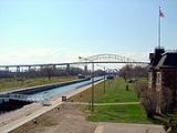
The Sault Ste. Marie Canal is a National Historic Site of Canada in Sault Ste. Marie
, Ontario
. The canal
is part of the shipping route
from the Atlantic Ocean to Lake Superior
and includes a set of locks
to bypass the rapid
s on the St. Marys River
.
The first lock was built in 1798 by the Northwest Trading Company. It was destroyed in 1814 in an attack by U.S. forces during the War of 1812
.
The construction of the canal and lock was completed in 1895. At that time it was the largest lock and first electrically operated lock in the world. The canal is about 1.6 kilometre (0.994196378639691 mi) long and originally the lock portion was 274 metres (899 ft) long and 18 metres (59.1 ft) wide.
On June 9, 1909 the locks were seriously damaged when the Perry G. Walker, owned by the Gilchrist Transportation Co. of Cleveland, Ohio, crashed into the south main gate, forcing it back and allowing the force of water to push the north main gate over. The rush of water threw the Walker back and carried two other ships downstream, one of which struck the south main gate, breaking it diagonally in two. The rush of water through the destroyed locks was stopped by activation of the Emergency Swing Bridge Dam, allowing repairs to commence. Amazingly, there was no loss of life or injury associated with this disaster, and repairs required only 12 days, with the bridge reopening on June 21, 1909.
The locks stopped operating when they were severely damaged by ice in 1987. A new lock, built within the old lock, was opened in 1998 and is 77 metres (252.6 ft) long, 15.4 metres (50.5 ft) wide and 3 metres (9.8 ft) deep. The canal is used for recreational and tour boats; major shipping traffic uses the U.S. locks.
There are several heritage
buildings on the site: the administration building, the superintendent's residence, the canalmen's shelter, the powerhouse and the blacksmith shop, all constructed from red sandstone
dug up during the canal's construction. Most of the original machinery used to operate the lock is also still in place. Another unique feature of the site is the emergency swing bridge
dam.
Guided tours are available in the summer only. The visitor centre is open year round.
Sault Ste. Marie, Ontario
Sault Ste. Marie is a city on the St. Marys River in Algoma District, Ontario, Canada. It is the third largest city in Northern Ontario, after Sudbury and Thunder Bay, with a population of 74,948. The community was founded as a French religious mission: Sault either means "jump" or "rapids" in...
, Ontario
Ontario
Ontario is a province of Canada, located in east-central Canada. It is Canada's most populous province and second largest in total area. It is home to the nation's most populous city, Toronto, and the nation's capital, Ottawa....
. The canal
Canal
Canals are man-made channels for water. There are two types of canal:#Waterways: navigable transportation canals used for carrying ships and boats shipping goods and conveying people, further subdivided into two kinds:...
is part of the shipping route
Great Lakes Waterway
The Great Lakes Waterway is a system of channels and canals that makes all of the Great Lakes accessible to oceangoing vessels. Its principal civil engineering components are the Welland Canal, bypassing Niagara Falls between Lake Ontario and Lake Erie, and the Soo Locks, bypassing the rapids of...
from the Atlantic Ocean to Lake Superior
Lake Superior
Lake Superior is the largest of the five traditionally-demarcated Great Lakes of North America. It is bounded to the north by the Canadian province of Ontario and the U.S. state of Minnesota, and to the south by the U.S. states of Wisconsin and Michigan. It is the largest freshwater lake in the...
and includes a set of locks
Lock (water transport)
A lock is a device for raising and lowering boats between stretches of water of different levels on river and canal waterways. The distinguishing feature of a lock is a fixed chamber in which the water level can be varied; whereas in a caisson lock, a boat lift, or on a canal inclined plane, it is...
to bypass the rapid
Rapid
A rapid is a section of a river where the river bed has a relatively steep gradient causing an increase in water velocity and turbulence. A rapid is a hydrological feature between a run and a cascade. A rapid is characterised by the river becoming shallower and having some rocks exposed above the...
s on the St. Marys River
St. Marys River (Michigan-Ontario)
The St. Marys River , sometimes written as the St. Mary's River, drains Lake Superior, starting at the end of Whitefish Bay and flowing 74.5 miles southeast into Lake Huron, with a fall of ....
.
The first lock was built in 1798 by the Northwest Trading Company. It was destroyed in 1814 in an attack by U.S. forces during the War of 1812
War of 1812
The War of 1812 was a military conflict fought between the forces of the United States of America and those of the British Empire. The Americans declared war in 1812 for several reasons, including trade restrictions because of Britain's ongoing war with France, impressment of American merchant...
.
The construction of the canal and lock was completed in 1895. At that time it was the largest lock and first electrically operated lock in the world. The canal is about 1.6 kilometre (0.994196378639691 mi) long and originally the lock portion was 274 metres (899 ft) long and 18 metres (59.1 ft) wide.
On June 9, 1909 the locks were seriously damaged when the Perry G. Walker, owned by the Gilchrist Transportation Co. of Cleveland, Ohio, crashed into the south main gate, forcing it back and allowing the force of water to push the north main gate over. The rush of water threw the Walker back and carried two other ships downstream, one of which struck the south main gate, breaking it diagonally in two. The rush of water through the destroyed locks was stopped by activation of the Emergency Swing Bridge Dam, allowing repairs to commence. Amazingly, there was no loss of life or injury associated with this disaster, and repairs required only 12 days, with the bridge reopening on June 21, 1909.
The locks stopped operating when they were severely damaged by ice in 1987. A new lock, built within the old lock, was opened in 1998 and is 77 metres (252.6 ft) long, 15.4 metres (50.5 ft) wide and 3 metres (9.8 ft) deep. The canal is used for recreational and tour boats; major shipping traffic uses the U.S. locks.
There are several heritage
Cultural heritage
Cultural heritage is the legacy of physical artifacts and intangible attributes of a group or society that are inherited from past generations, maintained in the present and bestowed for the benefit of future generations...
buildings on the site: the administration building, the superintendent's residence, the canalmen's shelter, the powerhouse and the blacksmith shop, all constructed from red sandstone
Sandstone
Sandstone is a sedimentary rock composed mainly of sand-sized minerals or rock grains.Most sandstone is composed of quartz and/or feldspar because these are the most common minerals in the Earth's crust. Like sand, sandstone may be any colour, but the most common colours are tan, brown, yellow,...
dug up during the canal's construction. Most of the original machinery used to operate the lock is also still in place. Another unique feature of the site is the emergency swing bridge
Swing bridge
A swing bridge is a movable bridge that has as its primary structural support a vertical locating pin and support ring, usually at or near to its centre of gravity, about which the turning span can then pivot horizontally as shown in the animated illustration to the right...
dam.
Guided tours are available in the summer only. The visitor centre is open year round.
See also
- Soo LocksSoo LocksThe Soo Locks are a set of parallel locks which enable ships to travel between Lake Superior and the lower Great Lakes. They are located on the St. Marys River between Lake Superior and Lake Huron, between the Upper Peninsula of the US state of Michigan and the Canadian province of Ontario...
- Locks on the U.S. side of St. Marys River - List of national historic sites of Canada
- Whitefish Island