

Satun Province
Encyclopedia

Provinces of Thailand
Thailand is divided into 76 provinces , which are geographically grouped into 6 regions. The capital Bangkok is not a province but a special administrative area and is included as the 77th province since it is administered at the same level as the other 76 provinces. The name of the provinces are...
(changwat) of Thailand
Thailand
Thailand , officially the Kingdom of Thailand , formerly known as Siam , is a country located at the centre of the Indochina peninsula and Southeast Asia. It is bordered to the north by Burma and Laos, to the east by Laos and Cambodia, to the south by the Gulf of Thailand and Malaysia, and to the...
. Neighboring provinces are (from north clockwise) Trang
Trang Province
Trang is one of the southern provinces of Thailand, at the western shore of the Malay Peninsula to the Andaman Sea. Neighboring provinces are Krabi, Nakhon Si Thammarat, Phatthalung and Satun....
, Phatthalung
Phatthalung Province
Phatthalung is one of the southern provinces of Thailand. Neighboring provinces are Nakhon Si Thammarat, Songkhla, Satun and Trang.-Geography:...
and Songkhla
Songkhla Province
Songkhla is one of the southern provinces of Thailand. Neighboring provinces are Satun, Phatthalung, Nakhon Si Thammarat, Pattani and Yala. To the south it borders Kedah and Perlis of Malaysia....
. To the south it borders Perlis
Perlis
Perlis is the smallest state in Malaysia. It lies at the northern part of the west coast of Peninsular Malaysia and has Satun and Songkhla Provinces of Thailand on its northern border. It is bordered by the state of Kedah to the south...
of Malaysia.
Etymology
The name Satun is a ThaiThai language
Thai , also known as Central Thai and Siamese, is the national and official language of Thailand and the native language of the Thai people, Thailand's dominant ethnic group. Thai is a member of the Tai group of the Tai–Kadai language family. Historical linguists have been unable to definitively...
version of its original Malay
Malay language
Malay is a major language of the Austronesian family. It is the official language of Malaysia , Indonesia , Brunei and Singapore...
name, Setul (santol
Santol (fruit)
The santol is a tropical fruit grown in Southeast Asia.-Origin and distribution:The santol is believed native to former Indochina and Peninsular Malaysia, and to have been introduced into India, Borneo, Indonesia, the Moluccas, Mauritius, and the Philippines where it has become naturalized...
, or wild mangosteen tree).
Geography
The province is located on the Malay PeninsulaMalay Peninsula
The Malay Peninsula or Thai-Malay Peninsula is a peninsula in Southeast Asia. The land mass runs approximately north-south and, at its terminus, is the southern-most point of the Asian mainland...
, on the shore of the Andaman Sea
Andaman Sea
The Andaman Sea or Burma Sea is a body of water to the southeast of the Bay of Bengal, south of Burma, west of Thailand and east of the Andaman Islands, India; it is part of the Indian Ocean....
. It is separated from Songkhla Province by the Nakhon Si Thammarat mountain range
Nakhon Si Thammarat mountain range
The Nakhon Si Thammarat mountain range is a mountain range on the Malay peninsula in southern Thailand, running in a north-south direction. This mountain chain is also sometimes named Banthat mountain range , a name which is however also used to refer to the Chanthaburi mountain...
, and from Malaysia by the Sankalakhiri mountains
Sankalakhiri mountain range
The Sankalakhiri mountain range is the natural border between Thailand and Malaysia.This mountain range is a part of the Tenasserim Hills system...
.
The Ko Tarutao
Tarutao National Marine Park
Tarutao National Marine Park consists of 51 islands located in the Andaman Sea, off the coast of Satun Province of Southern Thailand. The Tarutao National Marine Park consists of two island groups: Tarutao and Adang-Rawi , which are scattered from 20 to 70 kilometers distance from the...
and Ko Phetra
Mu Ko Phetra National Park
Mu Ko Phetra is a marine national park in Andaman Sea side of Thailand, covering mostly intact coastal line, open water, and about 30 islands of southern part of Trang Province and northern part of Satun Province...
marine national parks are part of the province. Close to the border with Malaysia is the Thale Ban National Park
Thale Ban National Park
Thale Ban National Park is a forested area south of the Banthat Mountains in Southern Thailand, at the south of Satun Province directly at the boundary to Malaysia. The park was established on 27 October 1980...
, a big freshwater swamp area.
History
Until 1813 Satun was a district of the Malay state of KedahKedah
Kedah is a state of Malaysia, located in the northwestern part of Peninsular Malaysia. The state covers a total area of over 9,000 km², and it consists of the mainland and Langkawi. The mainland has a relatively flat terrain, which is used to grow rice...
, then known as Setul Mambang Segara or Mukim Setul (Jawi: مقيم ستول)in Malay. After that date it was administered by a governor sent from Nakhon Si Thammarat
Nakhon Si Thammarat kingdom
Nakhon Si Thammarat Kingdom was one of the major constituent city states of the Siamese kingdoms of Sukhothai and later Ayutthaya and controlled a big part of the Malay peninsula...
. In 1897 Satun became part of Monthon Saiburi
Syburi
Saiburi is the name for the Malay state of Kedah returned to Thailand when the Japanese occupied British Malaya during World War II....
(now Kedah
Kedah
Kedah is a state of Malaysia, located in the northwestern part of Peninsular Malaysia. The state covers a total area of over 9,000 km², and it consists of the mainland and Langkawi. The mainland has a relatively flat terrain, which is used to grow rice...
), which in 1909 was divided between British Empire
British Empire
The British Empire comprised the dominions, colonies, protectorates, mandates and other territories ruled or administered by the United Kingdom. It originated with the overseas colonies and trading posts established by England in the late 16th and early 17th centuries. At its height, it was the...
and Siam as part of Anglo-Siamese Treaty of 1909
Anglo-Siamese Treaty of 1909
The Anglo-Siamese Treaty of 1909 or Bangkok Treaty of 1909 was a treaty between the United Kingdom and the Kingdom of Siam signed on March 10, 1909, in Bangkok. Ratifications were exchanged in London on July 9, 1909....
. While most of Kedah was ceded to Britain, Satun was awarded to Siam because it had a relatively large Thai population. Satun was then incorporated into Monthon Phuket. The monthon system was ended in 1933, and Satun province became a first-level subdivision of Thailand.
Demographics
Satun is one of the four provinces of Thailand which have a MuslimMuslim
A Muslim, also spelled Moslem, is an adherent of Islam, a monotheistic, Abrahamic religion based on the Quran, which Muslims consider the verbatim word of God as revealed to prophet Muhammad. "Muslim" is the Arabic term for "submitter" .Muslims believe that God is one and incomparable...
majority: 67.8% are Muslim and 31.9% are Buddhists. Most of the Muslims have some ethnic-Malay
Malay people
Malays are an ethnic group of Austronesian people predominantly inhabiting the Malay Peninsula, including the southernmost parts of Thailand, the east coast of Sumatra, the coast of Borneo, and the smaller islands which lie between these locations...
ancestry, though only 9.9% of the population claims to be ethnically Malay
Malay people
Malays are an ethnic group of Austronesian people predominantly inhabiting the Malay Peninsula, including the southernmost parts of Thailand, the east coast of Sumatra, the coast of Borneo, and the smaller islands which lie between these locations...
. The Malay dialect used in Satun is distinctly different from Pattani Malay and is much closer to the Kedah
Kedah Malay
Kedah Malay is a form of Malay spoken in the Malaysian states of Kedah, Penang, Perak, and Perlis. It is also spoken in Thailand's southern province of Satun, where it is called "Satun Malay"....
dialect of Malay, with a significant admixture of Thai influences.
Since Satun had belonged to the Kedah Sultanate, which had a strong relationship with both Ayutthaya
Ayutthaya kingdom
Ayutthaya was a Siamese kingdom that existed from 1350 to 1767. Ayutthaya was friendly towards foreign traders, including the Chinese, Vietnamese , Indians, Japanese and Persians, and later the Portuguese, Spanish, Dutch and French, permitting them to set up villages outside the walls of the...
and Siam under the Chakri dynasty, its Malay Muslims commonly intermarry with Thai Buddhists without serious religious hesitation. This custom has created a distinct social group known as Samsam, meaning a mixed person. Most Samsams, if not all, are Muslims.
Unlike the other Muslim majority provinces in Thailand, Satun does not have a history of political confrontation with the central power in Bangkok or of tension with the Buddhist population which makes up the majority of Thailand as a country. Malay Muslims in Satun are substantially assimilated and rarely sympathise with separatism from Thailand, in contrast to the Malay Muslims in Pattani
Pattani Province
Pattani is one of the southern provinces of Thailand. Neighboring provinces are Narathiwat, Yala and Songkhla.-Geography:...
, Narathiwat
Narathiwat Province
Narathiwat is one of the southern provinces of Thailand. Neighboring provinces are Yala and Pattani. To the south it borders the Malaysian state of Kelantan. The southern railway line ends in this province that is one of the nation’s five provinces that borders Malaysia. The name of this...
and Yala
Yala Province
Yala is the southernmost province of Thailand. Neighboring provinces are Songkhla, Pattani and Narathiwat. Yala is the only land-locked province in the south of Thailand...
.
Symbols
The provincial sealSeals of The Provinces of Thailand
-Present-day provinces of Thailand:This list includes all the seals of the Provinces of Thailand. It also includes the special administrative area of the capital, Bangkok.-Former Provinces:-External links:*...
shows Pra Samut Thewaa sitting on a stone in the sea, with the sunset behind. Pra Samut Thewaa is a spirit who guards the sea. The stone is his divine vehicle. The sunset symbolizes the Andaman Sea
Andaman Sea
The Andaman Sea or Burma Sea is a body of water to the southeast of the Bay of Bengal, south of Burma, west of Thailand and east of the Andaman Islands, India; it is part of the Indian Ocean....
, which lies to the west of the province.
The provincial tree is the Thai Rosewood or Pha-yungklaep (Dalbergia bariensis
Dalbergia bariensis
Dalbergia bariensis is a species of legume in the Fabaceae family.It is found in Cambodia, Laos, Thailand, and Vietnam.It is threatened by habitat loss.-Source:* Nghia, N.H. 1998. . Downloaded on 19 July 2007....
), and the provincial flower is the Snowy Orchid Tree (Bauhinia acuminata
Bauhinia acuminata
Bauhinia acuminata is a species of flowering shrub native to tropical southeastern Asia. Common names include: Dwarf White Bauhinia, White Orchid-tree and Snowy Orchid-tree...
). The province's motto is Peaceful, Clean and Pure Nature.
Administrative divisions
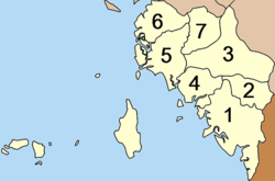
Amphoe
An amphoe is the second level administrative subdivision of Thailand. Usually translated as district, amphoe make up the provinces, and are analogous to a county seat...
). These are further subdivided into 36 subdistricts (tambon
Tambon
Tambon is a local government unit in Thailand. Below district and province , they form the third administrative subdivision level. As of the 2009 there are 7255 tambon, not including the 169 khwaeng of Bangkok, which are set at the same administrative level, thus every district contains 8-10 tambon...
) and 277 villages (muban
Muban
Muban is the lowest administrative subdivision of Thailand. Usually translated as village, they are the subdivision of tambon. As of 2008, there are 74944 administrative villages in Thailand. As of the 1990 census, the average village consisted of 144 households or 746 persons.A muban does not...
). Satun
Satun
Satun is a town in southern Thailand, capital of the Satun Province. It covers the whole tambon Phiman of Mueang Satun district. As of 2005 it has a population of 21,498....
itself is the only town (thesaban mueang), there are further 5 townships (thesaban tambon). The non-municipal area is administrated by 35 tambon administrative organizations (TAO).
|
|
Originally, the province was subdivided into 2 districts - Mambang and Thung Wa - and the minor district (King Amphoe) La-ngu. Due to the decline of pepper production in Thung Wa district, in 1930 the government made Thung Wa a minor district
District
Districts are a type of administrative division, in some countries managed by a local government. They vary greatly in size, spanning entire regions or counties, several municipalities, or subdivisions of municipalities.-Austria:...
and instead declared La-ngu a district. In 1939 Mambang was renamed to Mueang Satun. Khuan Kalong was split off from Mueang district in 1969, from which in turn Tha Pae was split in 1976 and Manang in 1996. In 1973 Thung Wa regained district status. Khuan Don was established in 1975 by splitting it from Mueang district.
Sights
Satun Central Mosque or Mambang Mosque (มัสยิดกลางจังหวัดสตูลหรือมัสยิดมำบัง) It is a place for religious services. The mosque is in a modern style of architecture. Its white building is decorated with glazed tiles, marble, and glass.Satun National Museum – Kuden Mansion / Istana Tengku Kudin of Kedah (พิพิธภัณฑสถานแห่งชาติสตูล – คฤหาสน์กูเด็น) During 1997–2000, the Fine Arts Department renovated the Kuden Mansion into a western two-storey brick building. Curved doors and windows are in the European architectural style of art. Its Thai-styled hip-roof is covered with Spanish terra cotta roof tiles. The top of the pediment is adorned with a star-shaped vent in accordance with Islamic architecture.
Khao To Phaya Wang Public Park (สวนสาธารณะเขาโต๊ะพญาวัง) This park offers a distinctive atmosphere unlike other parks.
Wat Chanathip Chaloem (วัดชนาธิปเฉลิม) This is the first Buddhist temple in the town of Satun. The Ubosot (ordination hall) has distinctive features, unlike an ordination hall in general. It is a Thai-styled two-storey building. The first storey is a brick building used as a preaching hall. The second storey is a wooden building for religious practice by Buddhist monks.
Laem Tanyong Po and Hat Sai Yao (แหลมตันหยงโปและหาดทรายยาว) is a cape jutting into the Andaman Sea where there is a fishing village. Its long sandy beach is fringed with coconut trees and fishermen’s houses.
Tarutao National Park (อุทยานแห่งชาติตะรุเตา) It is the first marine national park of Thailand. The park is renowned for its history and natural beauty. The area was declared a national park on 19 April 1974, and ASEAN Heritage Parks and Reserves by UNESCO in 1982. Attractions in the Tarutao National Park:
Ko Tarutao (เกาะตะรุเตา) It is the largest island of the park, covering an area of 152 km². Most of the areas are mountains with a moist evergreen forest, interesting species of plants and wildlife. Some part of the area is a mangrove forest. There are many bays, both small and large, with beautiful beaches. Attractions on Ko Tarutao:
Ao Phante Melaka (อ่าวพันเตมะละกา) It is a bay with a clean long white beach. The headquarters of the Tarutao National Park is located here.
Ao Chak (อ่าวจาก) This small bay is next to Ao Phante Melaka.
Ao Mo Lae (อ่าวเมาะและ) The bay possesses a clean white sandy beach. There is a beautiful grove of coconut trees amidst tranquility.
Ao Son (อ่าวสน) This curve-shaped bay has sandy beaches which are interspersed with rocky beaches. It is also an egg-laying ground for sea turtles.
Ao Talo Wao (อ่าวตะโละวาว) It is a historical area where the reformatory estate for detention and critical prisoners was established. Nowadays, the park has imitation buildings of the past.
Ao Talo Udang (อ่าวตะโละอุดัง) It is a bay located to the south of the island, 8 km from Ko Langkawi. The Park’s Ranger Station To To 2 (Talo Udang) is situated here. In the past, it was where political prisoners from the Bowondet and Nai Sip rebels were detained.
Namtok Ludu (น้ำตกลูดู) It is a small beautiful waterfall, around 3 km from Ao Son. There is a nature trail from Ao Son to Namtok Ludu.
Tham Chorakhe (ถ้ำจระเข้) It is a cave of 300 m in depth. Inside, beautiful stalactites and stalagmites can be found in different forms.
Pha To Bu Viewpoint (จุดชมวิวผาโต๊ะบู) Pha To Bu is a cliff 60 m above sea level. The viewpoint is behind the park’s headquarters, overlooking the beach of Ao Phante Melaka, Ko Bulon, Ko Klang, Ko Khai, Ko Adang, Ko Rawi, and Muko Phetra.
Ko Khai (เกาะไข่) It is an island to the west of Ko Tarutao. This small island is located between Ko Tarutao and Ko Adang. The famous feature of Ko Khai is its natural stone arch which is used as the symbol of the Tarutao National Park. Coral reefs are commonly found in the sea around Ko Khai.
Muko Adang – Rawi (หมู่เกาะอาดัง – ราวี) These are the islands located 40 km to the southwest of Ko Tarutao, or 60 km from the town of Satun.
Ko Adang (เกาะอาดัง) The island has an area of around 30 km2, with many beautiful beaches of fine sand. It is surrounded by small islands, and is an ideal place for skin-diving.
Ko Rawi (เกาะราวี) This island has an area of about 29 km2, with beautiful beaches, crystal clear sea, and serenity.
Ko Lipeh or Ko Lipe (เกาะสิเป๊ะหรือเกาะหลีเป๊ะ) There is a community of Moken (Chao Le or Andaman Sea Gypsies) here. Most families earn a living by fishing. Most importantly, the villagers will build boats from Rakam wood and perform a ceremony to float the boat, according to their belief in the prediction of their fishing. Ko Lipe is becoming a major tourist destination with many bungalow complexes on the two main beaches, Pattaya and Sunrise Beach.
Ko Hin Ngam (เกาะหินงาม) It is a small island located to the southwest of Ko Adang. On the beach, there are smooth black stones in different shapes and with beautiful patterns. The stones will be bright and glossy when wet.
Ko Yang or Ko Kata (เกาะยางหรือเกาะกาต๊ะ) Here, the sea is crystal clear and it is a source of beautiful hard corals, such as staghorn coral, leaf coral, and brain coral.
Ko Chabang (เกาะจาบัง) It is a small island. Deep down around the submerged rocks is the habitat of soft corals, sea anemones, and schools of colourful fish.
Muko Dong (หมู่เกาะดง) It is the islands on the farthest outer ring of Muko Adang – Rawi, around one hour from Ko Adang. There are coral reefs in both shallow and deep sea. Around Ko Dong are 4 – 5 satellite islands. One of them is Ko Hin Son, which prominently looks like superimposed rocks.
Tham Lot Puyu (ถ้ำลอดปูยู) This passable cave is like the one in Ao Phang-nga. Khlong Tha Chin or Tha Chin Canal flows through the cave. Mangrove forests flank the canal throughout its course. Inside the cave, there are some stalactites and stalagmites.
Thale Ban National Park (อุทยานแห่งชาติทะเลบัน) Most of the areas are a complex of mountains and dense woods. Wild animals found here include serow, elephant, tapir, common wild pig, monkey, gibbon, and Khiat Wak, or Ma Nam (Giant Asiatic toad or Malayan giant toad). Attractions in the Thale Ban National Park:
Bueng Thale Ban (บึงทะเลบัน) It is a freshwater lake located in the middle of a valley flanked by the Chin and the Wang Pra Ranges.
Namtok Ya Roi (น้ำตกยาโรย) It originates from a source in the Hua Kraming Forest.
Namtok Ton Plio (น้ำตกโตนปลิว) It originates from Mount Chin. This large and beautiful multi-tiered waterfall flows from a high cliff.
Thai – Malaysian Border Zone or Wang Prachan Checkpoint (เขตชายแดนไทย – มาเลเซียหรือด่านวังประจัน). It is just 2 km from the park’s headquarters. Located here is the Thale Ban National Park Ranger Station.
Namtok Thara Sawan Forest Park (วนอุทยานน้ำตกธาราสวรรค์) The area was declared a forest park by the Royal Forest Department on 23 July 1996. Regular rain causes an abundant evergreen forest here.
Namtok Panan (น้ำตกปาหนัน) It is located in Tambon Thung Nui, 39 km from the town of Satun. The waterfall originates from Mount Kaming. The surrounding nature is still intact. It has water flowing all year round. A power generating dam of a medium scale has been built in the waterfall area.
La-ngu Local Museum (พิพิธภัณฑ์พื้นบ้านละงู) The museum building has 2 storeys. On the ground floor, there are local handicrafts and sweets for sale. A museum on the upper floor displays brassware, earthenware, silverware, etc. which are the private collection of Mr. Chaiwat Saikun.
Muko Phetra National Park (อุทยานแห่งชาติหมู่เกาะเภตรา) Most of the areas are high and steep mountains with valley plains and beaches. The national park has forests, mountains, wildlife, and colourful coral reefs. It is composed of large and small main islands. Attractions in the Muko Phetra National Park:
Ao Nun (อ่าวนุ่น) It is a bay where the park’s headquarters is located. Ao Nun lies on a vast bay curve in serenity.
Hat Rawai (หาดราไว) The beach is fringed with lines of pine trees.
Ko Lidi Lek (เกาะลิดีเล็ก) The Park’s Ranger Station is located here. A white sandy beach lies on the island. A virgin mangrove forest grows at the island’s side where various aquatic animals inhabit.
Ko Bulon (เกาะบุโหลน) There are scattered spots for snorkelling and scuba diving, such as Ko Ayam and Ko Hin Khao. At night, hermit crabs and ghost crabs can be seen on the beach.
Namtok Wang Sai Thong (น้ำตกวังสายทอง) The beauty of this waterfall is the limestone in the shape of multi-petalled lotus flowers settling on the bottom of the pools at each of its tiers.
Namtok Than Plio (น้ำตกธารปลิว) It originates from Mount Lung Khroe in the provincial areas of Satun and Trang. This two-tiered waterfall has a pool of 40 m wide and 50 m long at its base. The surrounding area is shady with various plants.
Festivals
International Kite Festival Held every year around February at the Satun Airport, around 4 km before the town of Satun.Tarutao – Adang Fishing Club Fair Held every year around March.
Satun Marine Tourism Festival Held around December to mark the start of the marine tourism season in Satun.
Boat Floating Tradition To be observed by Chao Le or sea dwellers at Ko Lipe in Satun around the middle of the sixth and eleventh lunar months of every year. It is intended to dispel bad luck, as well as predict their fishing.
External links
Satun Thailand website http://www.satunthailand.com