

Saskatchewan Highway 41
Encyclopedia
Highway 41 is a highway
in the Canadian
province of Saskatchewan
. It runs from Highway 5
in Saskatoon
to Highway 6
/Highway 3
in Melfort
. Highway 41 is about 163.8 kilometres (101.8 mi). long.
Highway 41 also intersects Highway 2
. Also along the route, it passes near the communities of Aberdeen
and Wakaw
.
The town of Aberdeen, population 550 is located about 20 miles (32.2 km) north east of Saskatoon
. Aberdeen incorporated as a village in 1907. The small hamlet
of Edenburg
is 3 miles (4.8 km) northeast of Aberdeen. The village
of Alvena has a population of about 55 residents. According to the 2006 census the One Arrow 95-1C Indian Reserve
had a population of zero living on their 1.68 square kilometre (0.648651626435459 sq mi) land allotment. Wakaw is a town which began with the establishment of the Presbyterian Geneva Mission in 1903. In 1992, a memorial was erected in recognition of the Anna Turnbull Memorial Hospital and the Geneva Mission. Melfort, the City of Northern Lights is located in the Carrot River
valley. The city was first named the Stoney Creek settlement which changed when the post office in the area was named. Melfort became a village
in 1903, a town
in 1907, and a city
in 1980. The valley area with black loamy soil is prime agriucltural lands. Located at Melfort is the Agriculture Melfort Research Station.
of Aberdeen No. 373 is outside of Corman Park 344 which circumnavigates the city of Saskatoon. The RM of Aberdeen was incorporated July 26, 1909. Since 1909 one township of the RM was annexed by the RM of Comran Park. Highway 41 and the Canadian National Railway
(CNR) line both support transportation to Aberdeen. Agriculture is the main economy of the area which provides a base for Horizon Seed Processors, Louis Dreyfus High Throughput Grain Germinal and Hold On Industries. The main portion of RM Three Lakes No. 400 is south of Highway 41, The RM's name comes from Basin Lake, Lenore Lake and Middle Lake which are fully or partially within the RM area. LID #21-S-2 became Invergordon No. 430 and LID #221-R-2 is now Flett's Springs no. 430. In 1908 LID #21-S-2 paid to foremen in the area 22 cents per hour, a laborer received 20 cents per hour and a man with team received 40 cents an hour. An additional 25 cents per day were paid for use of plow when it was needed. In 1914, rates went up. A man with team received 50 cents an hour, a man or a team 25 cents an hour and 30 cents an hour for a foreman. Two slushers and scrapers could be ordered for each district, the quantity dependent upon roads and sloughs in the area. The rail survey began in 1929 and the Meskanaw bridge construction began. The Meskanaw station was opened around 1935 and passenger trains continued until 1977. Technology at this time allowed vehicles open roads through the winter months, and rails went into disuse. Flett's Springs is in an boreal transition ecoregion
which has some features of aspen parkland and boreal forest vegetation. The Flett's Springs School was established as early as 1894. The community established the Local Improvement District (LID) NO. 21 and 22 in the area as the civic government. The LID changed names to Carrot River Municipality No. 429 in 1910. It wasn't until 1938 that the present land holdings and the name of RM of Flett's Spring's No. 419 was in effect. The area became a part of the Saskatchewan Association of Rural Municipalities
(SARM) at the same time. The RM office is housed in Melfort as of 1989, with the first offices being in Pathlow
.
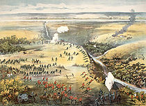 The Fish Creek Historical Site commemorates Major General Frederick Middleton's camp. The actual Battle of Fish Creek
occurred 1 miles (1.6 km) southeast of this camp. The Clarkboro Ferry
crosses the South Saskatchewan River
near the old ferry crossing which was named Clarke's Crossing. Clarke's Crossing was used by General Middleton's troops when travelling to the Fish Creek Battle enroute from North Battleford
. There is a marker on the Edenburg
road which pays tribute to Clarke's Crossing Ferry service. Flett Creek and Goosehunting Creek both meander through the RM of Flett's Springs. To the north of Melfort is Wapiti Regional Park at Codette Lake. The City of Melfort provides a campground at the highway junction of Highway 3, the CanAm
and Highway 41. The historical Melfort power house has been renovated for the Melfort and District Museum.
's eastern city limits, Highway 5
connects with Highway 41 at the site of a small commercial area that, as of 2007, included the Sundown Drive-In, one of Canada's last operational drive-in movie theatres. At Km 2.9, Highway 41 is traveling north east and crosses Llewellin Road, exiting Saskatoon's city limits. The Agra Road intersection is at Km 4.2. Continuing north east, Highway 41 meets with Bettken Road at 9.8 km. the Intersection with Hwy 27
is at Aberdeen
. Alvena
can be accessed at Km 40.1. One Arrow 95-1C Indian Reserve
is north of the highway at Km 61.9. Travel continues north east arriving at the Highway 22
intersection at Km 78.0. Highway 312
is just north of this intersection meeting with Highway 22
. Travel west along Highway 312 will traverse the South Saskatchewan River via the a three span bridge. Travel continues on Highway 41 due east. The town
of Wakaw
and Wakaw Lake Regional Park are accessed via Highway 2. At Km 95.0, the Highway returns to its north east direction. The village of Reynaud is to the east of this mile point. AT Km 107.8, Highway 41 intersects with Highway 20
. Yellow Creek
is located at Km 117.8, travel on Highway 41 is due east at this juncture. In approximately 12 miles (19.3 km), the highway returns to its north east direction. Meskanaw
is located at Km 129.6. Travel along Highway 41 is now due east. There is a curve at Km 138.1 when Highway 41 meets with Highway 776
which continues the due east direction. Highway 41 travels in a north east direction. At Km 148.5, Highway 41 intersects with Highway 368
. Highway 3
and Highway 6
, the CanAm Highway
are traveling south and north as a concurrency when they intersect with Highway 41 south of the city of Melfort
.
As of July 2010, several kilometres of Highway 41 were included in a large annexation of land undertaken by the City of Saskatoon.http://www.saskatoon.ca/DEPARTMENTS/Community%20Services/PlanningDevelopment/FutureGrowth/Pages/BoundaryAlterationProposal.aspxhttp://www.saskatoon.ca/DEPARTMENTS/Community%20Services/PlanningDevelopment/Documents/Mapping/Wall_maps/zoning_map.pdf
Published in Yellow Creek, Sask. by Yellow Creek History Committee, 1982
ISBN 0889253161
Highway
A highway is any public road. In American English, the term is common and almost always designates major roads. In British English, the term designates any road open to the public. Any interconnected set of highways can be variously referred to as a "highway system", a "highway network", or a...
in the Canadian
Canada
Canada is a North American country consisting of ten provinces and three territories. Located in the northern part of the continent, it extends from the Atlantic Ocean in the east to the Pacific Ocean in the west, and northward into the Arctic Ocean...
province of Saskatchewan
Saskatchewan
Saskatchewan is a prairie province in Canada, which has an area of . Saskatchewan is bordered on the west by Alberta, on the north by the Northwest Territories, on the east by Manitoba, and on the south by the U.S. states of Montana and North Dakota....
. It runs from Highway 5
Saskatchewan Highway 5
This article focuses on the current designated Saskatchewan Highway 5, for Provincial Highway 5, Evergreen route portion, north west of Saskatoon see Saskatchewan Highway 16....
in Saskatoon
Saskatoon
Saskatoon is a city in central Saskatchewan, Canada, on the South Saskatchewan River. Residents of the city of Saskatoon are called Saskatonians. The city is surrounded by the Rural Municipality of Corman Park No. 344....
to Highway 6
Saskatchewan Highway 6
Highway 6 is a paved undivided major provincial highway in the Canadian province of Saskatchewan. It runs from Montana Highway 16 at the Saskatchewan border with the US near the Canada customs port of Regway to Highway 55 near Choiceland. Highway 6 is about long. The CanAm Highway comprises ...
/Highway 3
Saskatchewan Highway 3
Highway 3 is a major provincial paved undivided highway in the Canadian province of Saskatchewan. It runs from the Alberta border, continues west as Alberta Highway 45 to the Manitoba border, and then continues east as Highway 77. Highway 3 is about 615 km long. The CanAm Highway comprises ...
in Melfort
Melfort, Saskatchewan
Melfort is a small Canadian city in Saskatchewan, approximately southeast of Prince Albert, northwest of Saskatoon and north of Regina.According to The World Gazetteer, its population as of 2004 was 5,400...
. Highway 41 is about 163.8 kilometres (101.8 mi). long.
Highway 41 also intersects Highway 2
Saskatchewan Highway 2
Highway 2 is a provincial highway in the Canadian province of Saskatchewan. It is the longest Saskatchewan Highway, at 809 km . The highway is partially divided and undivided. However, only about near Moose Jaw, near Chamberlain, and near Prince Albert are divided highway...
. Also along the route, it passes near the communities of Aberdeen
Aberdeen, Saskatchewan
-Aberdeen Rec Complex:The Aberdeen Rec Complex is located in the town and consists of a Library, meeting room, ice rink, curling rink, bowling alley, dance studio, music room and meeting rooms.-Water supply:...
and Wakaw
Wakaw, Saskatchewan
-History:Wakaw is in hilly partially forested country east of the South Saskatchewan River. The area is part of the aspen parkland biome. Peopled primarily by settlers of Eastern European origin, historically it housed Prime Minister John Diefenbaker's law office from 1919 to 1925; Diefenbaker's...
.
Communities
| Communities |
|---|
|
The town of Aberdeen, population 550 is located about 20 miles (32.2 km) north east of Saskatoon
Saskatoon
Saskatoon is a city in central Saskatchewan, Canada, on the South Saskatchewan River. Residents of the city of Saskatoon are called Saskatonians. The city is surrounded by the Rural Municipality of Corman Park No. 344....
. Aberdeen incorporated as a village in 1907. The small hamlet
Hamlet
The Tragical History of Hamlet, Prince of Denmark, or more simply Hamlet, is a tragedy by William Shakespeare, believed to have been written between 1599 and 1601...
of Edenburg
Edenburg, Saskatchewan
Edenburg is a tiny hamlet or village located 4 miles northwest of the town of Aberdeen, Saskatchewan in Canada. Edenburg has a population of approximately 30 and is a mixed use residential/agricultural area....
is 3 miles (4.8 km) northeast of Aberdeen. The village
Village
A village is a clustered human settlement or community, larger than a hamlet with the population ranging from a few hundred to a few thousand , Though often located in rural areas, the term urban village is also applied to certain urban neighbourhoods, such as the West Village in Manhattan, New...
of Alvena has a population of about 55 residents. According to the 2006 census the One Arrow 95-1C Indian Reserve
One Arrow First Nation
One Arrow First Nation is a Canadian Cree First Nation. Its reserve is located just south of Batoche, Saskatchewan near the South Saskatchewan River about 100 km Northeast of Saskatoon. The One Arrow First Nation is in the aspen parkland biome. It is bordered by the Rural Municipalities of St....
had a population of zero living on their 1.68 square kilometre (0.648651626435459 sq mi) land allotment. Wakaw is a town which began with the establishment of the Presbyterian Geneva Mission in 1903. In 1992, a memorial was erected in recognition of the Anna Turnbull Memorial Hospital and the Geneva Mission. Melfort, the City of Northern Lights is located in the Carrot River
Carrot River
The Carrot River is a river in northeastern Saskatchewan, and northwestern Manitoba. The river begins at Waterhen Marsh located south of Kinistino, Saskatchewan and continues through northeast Saskatchewan until it empties into the Saskatchewan River north-west of The Pas, Manitoba.The Carrot...
valley. The city was first named the Stoney Creek settlement which changed when the post office in the area was named. Melfort became a village
Village
A village is a clustered human settlement or community, larger than a hamlet with the population ranging from a few hundred to a few thousand , Though often located in rural areas, the term urban village is also applied to certain urban neighbourhoods, such as the West Village in Manhattan, New...
in 1903, a town
Town
A town is a human settlement larger than a village but smaller than a city. The size a settlement must be in order to be called a "town" varies considerably in different parts of the world, so that, for example, many American "small towns" seem to British people to be no more than villages, while...
in 1907, and a city
City
A city is a relatively large and permanent settlement. Although there is no agreement on how a city is distinguished from a town within general English language meanings, many cities have a particular administrative, legal, or historical status based on local law.For example, in the U.S...
in 1980. The valley area with black loamy soil is prime agriucltural lands. Located at Melfort is the Agriculture Melfort Research Station.
Rural municipalities
The rural municipality (RM)Rural municipality
A rural municipality, often abbreviated RM, is a form of municipality in the Canadian provinces of Manitoba and Saskatchewan, perhaps best comparable to counties or townships in the western United States...
of Aberdeen No. 373 is outside of Corman Park 344 which circumnavigates the city of Saskatoon. The RM of Aberdeen was incorporated July 26, 1909. Since 1909 one township of the RM was annexed by the RM of Comran Park. Highway 41 and the Canadian National Railway
Canadian National Railway
The Canadian National Railway Company is a Canadian Class I railway headquartered in Montreal, Quebec. CN's slogan is "North America's Railroad"....
(CNR) line both support transportation to Aberdeen. Agriculture is the main economy of the area which provides a base for Horizon Seed Processors, Louis Dreyfus High Throughput Grain Germinal and Hold On Industries. The main portion of RM Three Lakes No. 400 is south of Highway 41, The RM's name comes from Basin Lake, Lenore Lake and Middle Lake which are fully or partially within the RM area. LID #21-S-2 became Invergordon No. 430 and LID #221-R-2 is now Flett's Springs no. 430. In 1908 LID #21-S-2 paid to foremen in the area 22 cents per hour, a laborer received 20 cents per hour and a man with team received 40 cents an hour. An additional 25 cents per day were paid for use of plow when it was needed. In 1914, rates went up. A man with team received 50 cents an hour, a man or a team 25 cents an hour and 30 cents an hour for a foreman. Two slushers and scrapers could be ordered for each district, the quantity dependent upon roads and sloughs in the area. The rail survey began in 1929 and the Meskanaw bridge construction began. The Meskanaw station was opened around 1935 and passenger trains continued until 1977. Technology at this time allowed vehicles open roads through the winter months, and rails went into disuse. Flett's Springs is in an boreal transition ecoregion
Flora of Saskatchewan
The native flora of the Saskatchewan includes vascular plants, plus additional species of other plants and plant-like organisms such as algae, lichens and other fungi, and mosses...
which has some features of aspen parkland and boreal forest vegetation. The Flett's Springs School was established as early as 1894. The community established the Local Improvement District (LID) NO. 21 and 22 in the area as the civic government. The LID changed names to Carrot River Municipality No. 429 in 1910. It wasn't until 1938 that the present land holdings and the name of RM of Flett's Spring's No. 419 was in effect. The area became a part of the Saskatchewan Association of Rural Municipalities
Saskatchewan Association of Rural Municipalities
The Saskatchewan Association of Rural Municipalities, often abbreviated as SARM, is an independent association that is responsible for representing the governments of the many rural municipalities in Saskatchewan. It is an official Government of Saskatchewan sanctioned corporation...
(SARM) at the same time. The RM office is housed in Melfort as of 1989, with the first offices being in Pathlow
Pathlow, Saskatchewan
Pathlow is a hamlet in the Canadian province of Saskatchewan. Listed as a designated place by Statistics Canada, the hamlet had a population of 15 in the Canada 2006 Census....
.
Major Attractions
Battle of Fish Creek
The Battle of Fish Creek , fought April 24, 1885 at Fish Creek, Saskatchewan, was a major Métis victory over the Dominion forces attempting to quell Louis Riel's North-West Rebellion...
occurred 1 miles (1.6 km) southeast of this camp. The Clarkboro Ferry
Clarkboro Ferry
The Clarkboro Ferry is a cable ferry in the Canadian province of Saskatchewan. The ferry crosses the South Saskatchewan River at Clark's Crossing, carrying Grid Road 784 across the river, and connecting Warman in the west and Aberdeen in the east. The ferry is named for the community of Clarkboro...
crosses the South Saskatchewan River
South Saskatchewan River
The South Saskatchewan River is a major river in Canada that flows through the provinces of Alberta and Saskatchewan....
near the old ferry crossing which was named Clarke's Crossing. Clarke's Crossing was used by General Middleton's troops when travelling to the Fish Creek Battle enroute from North Battleford
North Battleford, Saskatchewan
In the late 2000s a large number of Ruthenians have emigrated to Canada, concentrating in North Battleford.-History:Prior to European settlement, the Battlefords area was home to several aboriginal groups...
. There is a marker on the Edenburg
Edenburg, Saskatchewan
Edenburg is a tiny hamlet or village located 4 miles northwest of the town of Aberdeen, Saskatchewan in Canada. Edenburg has a population of approximately 30 and is a mixed use residential/agricultural area....
road which pays tribute to Clarke's Crossing Ferry service. Flett Creek and Goosehunting Creek both meander through the RM of Flett's Springs. To the north of Melfort is Wapiti Regional Park at Codette Lake. The City of Melfort provides a campground at the highway junction of Highway 3, the CanAm
CanAm Highway
CanAm Highway passes through these states in the United States; Texas, New Mexico, Colorado, Wyoming, South Dakota, North Dakota, as well as the province of Saskatchewan, Canada. The international Can-Am Highway travels along U.S. Route 85 and Interstate 25, connecting Mexico to Canada through...
and Highway 41. The historical Melfort power house has been renovated for the Melfort and District Museum.
Route
In side SaskatoonSaskatoon
Saskatoon is a city in central Saskatchewan, Canada, on the South Saskatchewan River. Residents of the city of Saskatoon are called Saskatonians. The city is surrounded by the Rural Municipality of Corman Park No. 344....
's eastern city limits, Highway 5
Saskatchewan Highway 5
This article focuses on the current designated Saskatchewan Highway 5, for Provincial Highway 5, Evergreen route portion, north west of Saskatoon see Saskatchewan Highway 16....
connects with Highway 41 at the site of a small commercial area that, as of 2007, included the Sundown Drive-In, one of Canada's last operational drive-in movie theatres. At Km 2.9, Highway 41 is traveling north east and crosses Llewellin Road, exiting Saskatoon's city limits. The Agra Road intersection is at Km 4.2. Continuing north east, Highway 41 meets with Bettken Road at 9.8 km. the Intersection with Hwy 27
Saskatchewan Highway 27
Highway 27 is a provincial highway in the Canadian province of Saskatchewan. Being 34 kilometres long, it runs from Highway 41 at Aberdeen to Highway 2 east of Prud'homme.-External links:*...
is at Aberdeen
Aberdeen, Saskatchewan
-Aberdeen Rec Complex:The Aberdeen Rec Complex is located in the town and consists of a Library, meeting room, ice rink, curling rink, bowling alley, dance studio, music room and meeting rooms.-Water supply:...
. Alvena
Alvena, Saskatchewan
-History:Many early settlers to Alvena were of Ukrainian decent. Many were peasant serf farmers in the Austro-Hungarian Empire. Others were from Poland and they erected Roman Catholic Churches in the area. Earlier Settlers along the South Saskatchewan River were Métis...
can be accessed at Km 40.1. One Arrow 95-1C Indian Reserve
One Arrow First Nation
One Arrow First Nation is a Canadian Cree First Nation. Its reserve is located just south of Batoche, Saskatchewan near the South Saskatchewan River about 100 km Northeast of Saskatoon. The One Arrow First Nation is in the aspen parkland biome. It is bordered by the Rural Municipalities of St....
is north of the highway at Km 61.9. Travel continues north east arriving at the Highway 22
Saskatchewan Highway 2
Highway 2 is a provincial highway in the Canadian province of Saskatchewan. It is the longest Saskatchewan Highway, at 809 km . The highway is partially divided and undivided. However, only about near Moose Jaw, near Chamberlain, and near Prince Albert are divided highway...
intersection at Km 78.0. Highway 312
Saskatchewan Highway 312
Highway 312 is a highway in the Canadian province of Saskatchewan. It runs from Highway 12 to Highway 2 near Wakaw. Highway 312 is about 78 km long....
is just north of this intersection meeting with Highway 22
Saskatchewan Highway 2
Highway 2 is a provincial highway in the Canadian province of Saskatchewan. It is the longest Saskatchewan Highway, at 809 km . The highway is partially divided and undivided. However, only about near Moose Jaw, near Chamberlain, and near Prince Albert are divided highway...
. Travel west along Highway 312 will traverse the South Saskatchewan River via the a three span bridge. Travel continues on Highway 41 due east. The town
Town
A town is a human settlement larger than a village but smaller than a city. The size a settlement must be in order to be called a "town" varies considerably in different parts of the world, so that, for example, many American "small towns" seem to British people to be no more than villages, while...
of Wakaw
Wakaw, Saskatchewan
-History:Wakaw is in hilly partially forested country east of the South Saskatchewan River. The area is part of the aspen parkland biome. Peopled primarily by settlers of Eastern European origin, historically it housed Prime Minister John Diefenbaker's law office from 1919 to 1925; Diefenbaker's...
and Wakaw Lake Regional Park are accessed via Highway 2. At Km 95.0, the Highway returns to its north east direction. The village of Reynaud is to the east of this mile point. AT Km 107.8, Highway 41 intersects with Highway 20
Saskatchewan Highway 20
Highway 20 is a major road intended for travel by the public between Highway 11 Lumsden to Highway 3 at Birch Hills. Saskatchewan's main roadways are located in the central/southern geographical land area of rolling prairie and grass land in a western Canadian prairie province. This highway is one...
. Yellow Creek
Yellow Creek, Saskatchewan
The organized hamlet of Yellow Creek is located in the parkland area of east central Saskatchewan north east of Wakaw, Saskatchewan and has a population of 45 people. It previously held the status of village. It is named after the creek that flows through it. The area consists mostly of Ukrainian...
is located at Km 117.8, travel on Highway 41 is due east at this juncture. In approximately 12 miles (19.3 km), the highway returns to its north east direction. Meskanaw
Meskanaw, Saskatchewan
Meskanaw is a small community south west of Melfort, Saskatchewan. Meskanaw is the Cree word for trail or road.The community, an organized hamlet with the status of designated place, had a population of 18 in the Canada 2006 Census.-References:...
is located at Km 129.6. Travel along Highway 41 is now due east. There is a curve at Km 138.1 when Highway 41 meets with Highway 776
Saskatchewan Highway 776
Highway 776 is a highway in the Canadian province of Saskatchewan. It runs from Highway 41 near Ethelton to Highway 23 near Bjorkdale. Highway 776 is about 99 km long....
which continues the due east direction. Highway 41 travels in a north east direction. At Km 148.5, Highway 41 intersects with Highway 368
Saskatchewan Highway 368
Highway 368 is a highway in the Canadian province of Saskatchewan. It runs from Highway 5 near Muenster to Highway 3 near Beatty. Highway 368 is about long....
. Highway 3
Saskatchewan Highway 3
Highway 3 is a major provincial paved undivided highway in the Canadian province of Saskatchewan. It runs from the Alberta border, continues west as Alberta Highway 45 to the Manitoba border, and then continues east as Highway 77. Highway 3 is about 615 km long. The CanAm Highway comprises ...
and Highway 6
Saskatchewan Highway 6
Highway 6 is a paved undivided major provincial highway in the Canadian province of Saskatchewan. It runs from Montana Highway 16 at the Saskatchewan border with the US near the Canada customs port of Regway to Highway 55 near Choiceland. Highway 6 is about long. The CanAm Highway comprises ...
, the CanAm Highway
CanAm Highway
CanAm Highway passes through these states in the United States; Texas, New Mexico, Colorado, Wyoming, South Dakota, North Dakota, as well as the province of Saskatchewan, Canada. The international Can-Am Highway travels along U.S. Route 85 and Interstate 25, connecting Mexico to Canada through...
are traveling south and north as a concurrency when they intersect with Highway 41 south of the city of Melfort
Melfort, Saskatchewan
Melfort is a small Canadian city in Saskatchewan, approximately southeast of Prince Albert, northwest of Saskatoon and north of Regina.According to The World Gazetteer, its population as of 2004 was 5,400...
.
As of July 2010, several kilometres of Highway 41 were included in a large annexation of land undertaken by the City of Saskatoon.http://www.saskatoon.ca/DEPARTMENTS/Community%20Services/PlanningDevelopment/FutureGrowth/Pages/BoundaryAlterationProposal.aspxhttp://www.saskatoon.ca/DEPARTMENTS/Community%20Services/PlanningDevelopment/Documents/Mapping/Wall_maps/zoning_map.pdf
Major intersections
Further reading
- Book Resource: Our pride and heritage : history of Yellow Creek and the surrounding school districts of Hazel Lake, Rhona Lake, Stoneless, Tarnopol, New Tarnopol, Yellow Creek
Published in Yellow Creek, Sask. by Yellow Creek History Committee, 1982
ISBN 0889253161