

Sapperton Canal Tunnel
Encyclopedia
Tunnel
A tunnel is an underground passageway, completely enclosed except for openings for egress, commonly at each end.A tunnel may be for foot or vehicular road traffic, for rail traffic, or for a canal. Some tunnels are aqueducts to supply water for consumption or for hydroelectric stations or are sewers...
on the Thames and Severn Canal
Thames and Severn Canal
The Thames and Severn Canal is a canal in Gloucestershire in the south of England, which was completed in 1789. It was conceived as part of a canal route from Bristol to London. At its eastern end, it connects to the River Thames at Inglesham Lock near Lechlade, while at its western end, it...
near Cirencester
Cirencester
Cirencester is a market town in east Gloucestershire, England, 93 miles west northwest of London. Cirencester lies on the River Churn, a tributary of the River Thames, and is the largest town in the Cotswold District. It is the home of the Royal Agricultural College, the oldest agricultural...
in Gloucestershire
Gloucestershire
Gloucestershire is a county in South West England. The county comprises part of the Cotswold Hills, part of the flat fertile valley of the River Severn, and the entire Forest of Dean....
, England
England
England is a country that is part of the United Kingdom. It shares land borders with Scotland to the north and Wales to the west; the Irish Sea is to the north west, the Celtic Sea to the south west, with the North Sea to the east and the English Channel to the south separating it from continental...
. It was the longest canal
Canal
Canals are man-made channels for water. There are two types of canal:#Waterways: navigable transportation canals used for carrying ships and boats shipping goods and conveying people, further subdivided into two kinds:...
tunnel, and the longest tunnel of any kind, in England from 1789 to 1811.
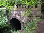
The tunnel was opened on 20 April 1789 after five years of construction and is 3817 yards (3,490.3 m) long. It has no towpath
Towpath
A towpath is a road or trail on the bank of a river, canal, or other inland waterway. The purpose of a towpath is to allow a land vehicle, beasts of burden, or a team of human pullers to tow a boat, often a barge...
; narrowboats were propelled through the tunnel by legging
Legging (canals)
Legging is a method of moving a boat through a canal tunnel or adit containing water.-Legging in canal tunnels:Early canal tunnels were built without a towpath as this would require a much larger bore, and hence cost more to build. Prior to the introduction of motorised boats, legging was one of...
.
It was superseded as the longest canal tunnel in England in 1811 by the Huddersfield Narrow Canal
Huddersfield Narrow Canal
The Huddersfield Narrow Canal is an inland waterway in northern England. It runs just under from Lock 1E at the rear of the University of Huddersfield campus, near Aspley Basin at Huddersfield to the junction with the Ashton Canal at Whitelands Basin in Ashton-under-Lyne...
's Standedge Tunnel
Standedge Tunnels
The Standedge Tunnels are four parallel tunnels that run beneath the Pennines at the traditional Standedge crossing point between Marsden and Diggle, on the edges of the conurbations of West Yorkshire and Greater Manchester respectively, in northern England.There are three railway tunnels and a...
, which is 5456 yards (4,989 m) long and remains the highest, longest and deepest canal tunnel in Britain
Great Britain
Great Britain or Britain is an island situated to the northwest of Continental Europe. It is the ninth largest island in the world, and the largest European island, as well as the largest of the British Isles...
- though, unlike Sapperton, Standedge can only accommodate 7 feet (2.1 m). Sapperton Tunnel is not currently navigable, but restoration is proposed by the Cotswold Canals Trust
Cotswold Canals Trust
The Cotswold Canals Trust is a registered charity that aims to protect and restore the Stroudwater Navigation and the Thames and Severn Canal. The group was founded in 1972....
as part of their project to re-open the canal route from Thames to Severn. The trust operates tourist boat trips into the tunnel in winter months.
The Sapperton railway tunnel
Sapperton Tunnel
The Sapperton Tunnels are located about seven miles East South East of Stroud in Gloucestershire, England.-History:The railway tunnel was begun by the Cheltenham and Great Western Union railway in 1839 and taken over by the Great Western Railway in 1843, being completed in 1845.There are three in...
, on the Golden Valley Line
Golden Valley Line
The Golden Valley Line is a railway line from Swindon to Cheltenham in the UK.The line was originally built as the Cheltenham and Great Western Union Railway in the 1840s...
, follows a broadly similar route under the 'Cotswold Edge'.
The Tunnel in Fiction
In Hornblower and the AtroposHornblower and the Atropos
Hornblower and the Atropos is a 1953 historical novel by C.S. Forester.In this novel, Horatio Hornblower is posted to HMS Atropos, the smallest vessel in the Royal Navy that merits command by a post-Captain, as he hunts for treasure in the Mediterranean Sea.-Plot summary:On a December day in 1805,...
by C.S. Forester, Hornblower helps the boatman "leg" through Sapperton Tunnel after the boatman's assistant is incapacitated. Forester spends the first two chapters of the book on the canal-boat journey, Roughly a third of the first chapter is devoted to the tunnel.
In the novel Gone by Mo Hayder
Mo Hayder
Mo Hayder is a British author of crime and thriller fiction.She is the author of eight novels. Her debut, Birdman, was published in January 2000 and was an international bestseller. Her second novel, The Treatment, was a Sunday Times bestseller and won the 2002 WH Smith Thumping Good Read award....
the tunnel is used extensively as a location in this crime thriller.
Coordinates
| Point | Coordinates Geographic coordinate system A geographic coordinate system is a coordinate system that enables every location on the Earth to be specified by a set of numbers. The coordinates are often chosen such that one of the numbers represent vertical position, and two or three of the numbers represent horizontal position... (links to map & photo sources) |
|---|---|
| Daneway portal | 51.7287°N 2.0828°W |
| Mid-point | 51.7162°N 2.0666°W |
| Coates portal | 51.7041°N 2.0504°W |