

Sandstorm (vehicle)
Encyclopedia
Unmanned ground vehicle
An unmanned ground vehicle is a military robot used to augment the soldiers capability. This type of robot is generally capable of operating outdoors and over a wide variety of terrain, functioning in place of humans....
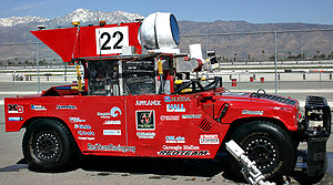
. Created by Carnegie Mellon University's Red Team, it is a heavily modified 1986 M998 HMMWV. It competed in the DARPA Grand Challenge
DARPA Grand Challenge
The DARPA Grand Challenge is a prize competition for driverless vehicles, funded by the Defense Advanced Research Projects Agency, the most prominent research organization of the United States Department of Defense...
in 2004 and 2005.
Sandstorm qualified in first position in the 2004 DARPA Grand Challenge. It traveled the fastest and farthest (7.4 miles) during the race before high centering on an embankment.
The sensors used by Sandstorm in 2004 included three fixed LIDAR
LIDAR
LIDAR is an optical remote sensing technology that can measure the distance to, or other properties of a target by illuminating the target with light, often using pulses from a laser...
laser-ranging units, one steerable LIDAR (in the globe on top), a RADAR
Radar
Radar is an object-detection system which uses radio waves to determine the range, altitude, direction, or speed of objects. It can be used to detect aircraft, ships, spacecraft, guided missiles, motor vehicles, weather formations, and terrain. The radar dish or antenna transmits pulses of radio...
unit (developed in collaboration with the Duke University Robotics Team), and a pair of cameras for stereo vision. Sandstorm also has a GPS and an inertial navigation system
Inertial navigation system
An inertial navigation system is a navigation aid that uses a computer, motion sensors and rotation sensors to continuously calculate via dead reckoning the position, orientation, and velocity of a moving object without the need for external references...
for determining geographical position. The GPS/ INS
Inertial navigation system
An inertial navigation system is a navigation aid that uses a computer, motion sensors and rotation sensors to continuously calculate via dead reckoning the position, orientation, and velocity of a moving object without the need for external references...
system was an Applanix
Applanix
Applanix based in Richmond Hill, Ontario, Canada develops and manufactures a line of Intertial Navigation System products. The company's Position and Orientation Systems are used worldwide for a variety of applications such as, aerial survey and mapping, remote sensing, road profiling, GIS data...
POS/LV system.
Since the 2004 race Sandstorm has been continually tested and modified, logging hundreds of test miles. Testing includes an unprecedented continuous 200 mile test run at an average of 28 miles per hour.
The 2005 version of Sandstorm uses six fixed LIDAR units, the steerable LIDAR, and short- and long-range RADAR.
Sandstorm competed in the 2005 DARPA Grand Challenge
DARPA Grand Challenge
The DARPA Grand Challenge is a prize competition for driverless vehicles, funded by the Defense Advanced Research Projects Agency, the most prominent research organization of the United States Department of Defense...
on October 8th, qualifying third from the pole position behind Stanley
Stanley (vehicle)
Stanley is an autonomous vehicle created by Stanford University's Stanford Racing Team in cooperation with the Volkswagen Electronics Research Laboratory...
and finished in 7 hours, 5 minutes, placing 2nd out of the five vehicles to complete the 132-mile course.