

San Remigio, Antique
Encyclopedia
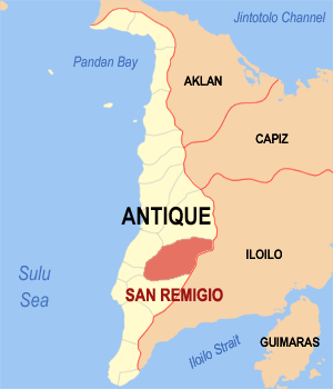
Antique province
Antique is a province of the Philippines located in the Western Visayas region. Its capital is San Jose and is located at the western portion of Panay Island, bordering Aklan, Capiz, and Iloilo to the east. Antique faces the Sulu Sea to the west....
, Philippines
Philippines
The Philippines , officially known as the Republic of the Philippines , is a country in Southeast Asia in the western Pacific Ocean. To its north across the Luzon Strait lies Taiwan. West across the South China Sea sits Vietnam...
. It is about 21 kilometers from the provincial capital, San Jose de Buenavista.
According to the 2000 census, it has a population of 26,079 people in 4,755 households.
Economy
Commerce in the municipality has improved with the completion of the Tipuluan Bridge. Commercial establishments are expected to rise in San Remigio after the realization of the San Remigio-Leon Road.The municipality of San Remigio produced a total of 13,074.02 metric tons of palay in an area of 41.87 km² of which only 22.00% are irrigated and the rest are rain fed and upland area.
The transport
Transport
Transport or transportation is the movement of people, cattle, animals and goods from one location to another. Modes of transport include air, rail, road, water, cable, pipeline, and space. The field can be divided into infrastructure, vehicles, and operations...
ation needs of the munersa. San Remigio has a road network of 187.452 kilometers. Based on administrative classification, 42.696 kilometers are municipal roads and 136.124 kilometers are barangay roads. There are eleven bridges in the municipality with a total length of 321.391 kilometers. All of the bridges are bailey and found along the national road.
Barangays
San Remigio is politically subdivided into 45 barangayBarangay
A barangay is the smallest administrative division in the Philippines and is the native Filipino term for a village, district or ward...
s.
|
|
|
Geography
San Remigio has a land area of 336.50 km², almost 70% of which are mountainous and the remaining 30% comprise the flat lowland and rolling hills.Agriculture occupies 47.815 km² of land. Of this, 44.37 km² is for food crops, 1.035 km² is for permanent crops, and 2.41 km² for commercial crops.