

San Miguel de Abona
Encyclopedia
| San Miguel de Abona | |
| Map | |
|---|---|
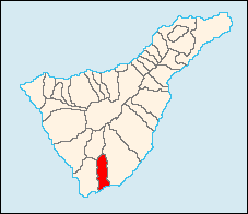 |
|
| Statistics | |
| Autonomous region: | Canary Islands Canary Islands The Canary Islands , also known as the Canaries , is a Spanish archipelago located just off the northwest coast of mainland Africa, 100 km west of the border between Morocco and the Western Sahara. The Canaries are a Spanish autonomous community and an outermost region of the European Union... |
| Province: | Santa Cruz de Tenerife Santa Cruz de Tenerife (province) Province of Santa Cruz de Tenerife also Province of Santa Cruz is a province of Spain, consisting of the western part of the autonomous community of the Canary Islands. It consists of about half of the Atlantic archipelago, including the islands of Tenerife, La Gomera, El Hierro, and La Palma, and... |
| Island: | Tenerife Tenerife Tenerife is the largest and most populous island of the seven Canary Islands, it is also the most populated island of Spain, with a land area of 2,034.38 km² and 906,854 inhabitants, 43% of the total population of the Canary Islands. About five million tourists visit Tenerife each year, the... |
| Area Area Area is a quantity that expresses the extent of a two-dimensional surface or shape in the plane. Area can be understood as the amount of material with a given thickness that would be necessary to fashion a model of the shape, or the amount of paint necessary to cover the surface with a single coat... : |
42.04 km² |
| Population Population A population is all the organisms that both belong to the same group or species and live in the same geographical area. The area that is used to define a sexual population is such that inter-breeding is possible between any pair within the area and more probable than cross-breeding with individuals... : |
9,988 (2001) |
| Population density Population density Population density is a measurement of population per unit area or unit volume. It is frequently applied to living organisms, and particularly to humans... : |
237.58/km² |
| Elevation Elevation The elevation of a geographic location is its height above a fixed reference point, most commonly a reference geoid, a mathematical model of the Earth's sea level as an equipotential gravitational surface .... : Lowest: Centre: Highest: |
Atlantic Ocean 600 m about 1,200 m (north) |
| Length of coastline: | about 4 to 5 km |
| Postal code: | - |
| Website: | www.sanmigueldeabona.org |
San Miguel de Abona (first part, Spanish
Spanish language
Spanish , also known as Castilian , is a Romance language in the Ibero-Romance group that evolved from several languages and dialects in central-northern Iberia around the 9th century and gradually spread with the expansion of the Kingdom of Castile into central and southern Iberia during the...
for Saint Michael) is the name of a municipality, town, and valley in the southeastern part of the island of Tenerife
Tenerife
Tenerife is the largest and most populous island of the seven Canary Islands, it is also the most populated island of Spain, with a land area of 2,034.38 km² and 906,854 inhabitants, 43% of the total population of the Canary Islands. About five million tourists visit Tenerife each year, the...
, one of the Canary Islands
Canary Islands
The Canary Islands , also known as the Canaries , is a Spanish archipelago located just off the northwest coast of mainland Africa, 100 km west of the border between Morocco and the Western Sahara. The Canaries are a Spanish autonomous community and an outermost region of the European Union...
, and part of the province of Santa Cruz de Tenerife
Santa Cruz de Tenerife (province)
Province of Santa Cruz de Tenerife also Province of Santa Cruz is a province of Spain, consisting of the western part of the autonomous community of the Canary Islands. It consists of about half of the Atlantic archipelago, including the islands of Tenerife, La Gomera, El Hierro, and La Palma, and...
. San Miguel de Abona is a suburb or a cluster of Tenerife Sur. The municipality is located in the southern end of the island. Arico is on a valley setting. Its estimated population is 9 988. San Miguel de Abona is linked with the TF1 Motorway
TF1 Motorway
The TF-1 is a superhighway encircling the eastern and the southern parts of the island of Tenerife . The TF-1 motorway runs from the capital Santa Cruz in the north to Adeje with its major tourist resorts Los Cristianos and Playa de las Américas in the south of the island...
and has an interchange south of San Miguel de Abona and north of its beaches and is also linked with the old highway linking Arona and Santa Cruz de Tenerife.
Its economy are businesses, tourism and some agriculture. In the south of the municipality, on the coastline, lies the golf course and holiday/residential village of Golf del Sur
Golf del Sur
Golf del Sur is a holiday resort and golf course situated in Tenerife, Canary Islands within the municipality of San Miguel de Abona.In 1989, 1992, 1993 and 1994, Golf del Sur hosted the Tenerife Open tournament.-History:...
. Some farmlands and a natural preserve also exist towards the coastline, while the mountains dominate much of the municipality and to the north. Tenerife South Airport
Tenerife South Airport
Tenerife South Airport , previously known as Tenerife South-Reina Sofia Airport, is one of two international airports located on the island of Tenerife, the largest of the Canary Islands . Between its opening and the end of 2006, a total of 173,912,207 passengers passed through the airport...
is in the eastern portion of the municipality.
Historical population
| Year | Population | Change | Density |
|---|---|---|---|
| March 1, 1991 | 5,118 | - | - |
| May 1, 1996 | 5,776 | - | - |
| 2001 | 8,398 | - | 199.95/km² |
| 2002 | 9,174 | - | - |
| 2003 | 9,988 | - | 237.58/km² |
| 2004 | 10,802 | - | 259.23/km² |
Other
San Miguel de Abona has schools, a lyceum, a gymnasium, banks, churches, a beaches and a few squares plazaPlaza
Plaza is a Spanish word related to "field" which describes an open urban public space, such as a city square. All through Spanish America, the plaza mayor of each center of administration held three closely related institutions: the cathedral, the cabildo or administrative center, which might be...
s.
External links
- Coalición Canaria San Miguel de Abona
- Hotel Rural San Miguel de Abona
San Miguel de Abona Map<-- Flag/Coat of arms--> --> Statistics Autonomous region: Canary Islands Canary IslandsThe Canary Islands , also known as the Canaries , is a Spanish archipelago located just off the northwest coast of mainland Africa, 100 km west of the border between Morocco and the Western Sahara. The Canaries are a Spanish autonomous community and an outermost region of the European Union...Province: Santa Cruz de Tenerife Santa Cruz de Tenerife (province)Province of Santa Cruz de Tenerife also Province of Santa Cruz is a province of Spain, consisting of the western part of the autonomous community of the Canary Islands. It consists of about half of the Atlantic archipelago, including the islands of Tenerife, La Gomera, El Hierro, and La Palma, and...Island: Tenerife TenerifeTenerife is the largest and most populous island of the seven Canary Islands, it is also the most populated island of Spain, with a land area of 2,034.38 km² and 906,854 inhabitants, 43% of the total population of the Canary Islands. About five million tourists visit Tenerife each year, the...Area AreaArea is a quantity that expresses the extent of a two-dimensional surface or shape in the plane. Area can be understood as the amount of material with a given thickness that would be necessary to fashion a model of the shape, or the amount of paint necessary to cover the surface with a single coat...
:42.04 km² Population PopulationA population is all the organisms that both belong to the same group or species and live in the same geographical area. The area that is used to define a sexual population is such that inter-breeding is possible between any pair within the area and more probable than cross-breeding with individuals...
:9,988 (2001) Population density Population densityPopulation density is a measurement of population per unit area or unit volume. It is frequently applied to living organisms, and particularly to humans...
:237.58/km² Elevation ElevationThe elevation of a geographic location is its height above a fixed reference point, most commonly a reference geoid, a mathematical model of the Earth's sea level as an equipotential gravitational surface ....
:
Lowest:
Centre:
Highest:
Atlantic Ocean
600 m
about 1,200 m (north)Length of coastline: about 4 to 5 km Postal code: - Website: www.sanmigueldeabona.org
San Miguel de Abona (first part, Spanish
Spanish language
Spanish , also known as Castilian , is a Romance language in the Ibero-Romance group that evolved from several languages and dialects in central-northern Iberia around the 9th century and gradually spread with the expansion of the Kingdom of Castile into central and southern Iberia during the...
for Saint Michael) is the name of a municipality, town, and valley in the southeastern part of the island of Tenerife
Tenerife
Tenerife is the largest and most populous island of the seven Canary Islands, it is also the most populated island of Spain, with a land area of 2,034.38 km² and 906,854 inhabitants, 43% of the total population of the Canary Islands. About five million tourists visit Tenerife each year, the...
, one of the Canary Islands
Canary Islands
The Canary Islands , also known as the Canaries , is a Spanish archipelago located just off the northwest coast of mainland Africa, 100 km west of the border between Morocco and the Western Sahara. The Canaries are a Spanish autonomous community and an outermost region of the European Union...
, and part of the province of Santa Cruz de Tenerife
Santa Cruz de Tenerife (province)
Province of Santa Cruz de Tenerife also Province of Santa Cruz is a province of Spain, consisting of the western part of the autonomous community of the Canary Islands. It consists of about half of the Atlantic archipelago, including the islands of Tenerife, La Gomera, El Hierro, and La Palma, and...
. San Miguel de Abona is a suburb or a cluster of Tenerife Sur. The municipality is located in the southern end of the island. Arico is on a valley setting. Its estimated population is 9 988. San Miguel de Abona is linked with the TF1 Motorway
TF1 Motorway
The TF-1 is a superhighway encircling the eastern and the southern parts of the island of Tenerife . The TF-1 motorway runs from the capital Santa Cruz in the north to Adeje with its major tourist resorts Los Cristianos and Playa de las Américas in the south of the island...
and has an interchange south of San Miguel de Abona and north of its beaches and is also linked with the old highway linking Arona and Santa Cruz de Tenerife.
Its economy are businesses, tourism and some agriculture. In the south of the municipality, on the coastline, lies the golf course and holiday/residential village of Golf del Sur
Golf del Sur
Golf del Sur is a holiday resort and golf course situated in Tenerife, Canary Islands within the municipality of San Miguel de Abona.In 1989, 1992, 1993 and 1994, Golf del Sur hosted the Tenerife Open tournament.-History:...
. Some farmlands and a natural preserve also exist towards the coastline, while the mountains dominate much of the municipality and to the north. Tenerife South Airport
Tenerife South Airport
Tenerife South Airport , previously known as Tenerife South-Reina Sofia Airport, is one of two international airports located on the island of Tenerife, the largest of the Canary Islands . Between its opening and the end of 2006, a total of 173,912,207 passengers passed through the airport...
is in the eastern portion of the municipality.
Canary Islands
The Canary Islands , also known as the Canaries , is a Spanish archipelago located just off the northwest coast of mainland Africa, 100 km west of the border between Morocco and the Western Sahara. The Canaries are a Spanish autonomous community and an outermost region of the European Union...
Santa Cruz de Tenerife (province)
Province of Santa Cruz de Tenerife also Province of Santa Cruz is a province of Spain, consisting of the western part of the autonomous community of the Canary Islands. It consists of about half of the Atlantic archipelago, including the islands of Tenerife, La Gomera, El Hierro, and La Palma, and...
Tenerife
Tenerife is the largest and most populous island of the seven Canary Islands, it is also the most populated island of Spain, with a land area of 2,034.38 km² and 906,854 inhabitants, 43% of the total population of the Canary Islands. About five million tourists visit Tenerife each year, the...
Area
Area is a quantity that expresses the extent of a two-dimensional surface or shape in the plane. Area can be understood as the amount of material with a given thickness that would be necessary to fashion a model of the shape, or the amount of paint necessary to cover the surface with a single coat...
:
Population
A population is all the organisms that both belong to the same group or species and live in the same geographical area. The area that is used to define a sexual population is such that inter-breeding is possible between any pair within the area and more probable than cross-breeding with individuals...
:
Population density
Population density is a measurement of population per unit area or unit volume. It is frequently applied to living organisms, and particularly to humans...
:
Elevation
The elevation of a geographic location is its height above a fixed reference point, most commonly a reference geoid, a mathematical model of the Earth's sea level as an equipotential gravitational surface ....
:
Lowest:
Centre:
Highest:
Atlantic Ocean
600 m
about 1,200 m (north)
San Miguel de Abona (first part, Spanish
Spanish language
Spanish , also known as Castilian , is a Romance language in the Ibero-Romance group that evolved from several languages and dialects in central-northern Iberia around the 9th century and gradually spread with the expansion of the Kingdom of Castile into central and southern Iberia during the...
for Saint Michael) is the name of a municipality, town, and valley in the southeastern part of the island of Tenerife
Tenerife
Tenerife is the largest and most populous island of the seven Canary Islands, it is also the most populated island of Spain, with a land area of 2,034.38 km² and 906,854 inhabitants, 43% of the total population of the Canary Islands. About five million tourists visit Tenerife each year, the...
, one of the Canary Islands
Canary Islands
The Canary Islands , also known as the Canaries , is a Spanish archipelago located just off the northwest coast of mainland Africa, 100 km west of the border between Morocco and the Western Sahara. The Canaries are a Spanish autonomous community and an outermost region of the European Union...
, and part of the province of Santa Cruz de Tenerife
Santa Cruz de Tenerife (province)
Province of Santa Cruz de Tenerife also Province of Santa Cruz is a province of Spain, consisting of the western part of the autonomous community of the Canary Islands. It consists of about half of the Atlantic archipelago, including the islands of Tenerife, La Gomera, El Hierro, and La Palma, and...
. San Miguel de Abona is a suburb or a cluster of Tenerife Sur. The municipality is located in the southern end of the island. Arico is on a valley setting. Its estimated population is 9 988. San Miguel de Abona is linked with the TF1 Motorway
TF1 Motorway
The TF-1 is a superhighway encircling the eastern and the southern parts of the island of Tenerife . The TF-1 motorway runs from the capital Santa Cruz in the north to Adeje with its major tourist resorts Los Cristianos and Playa de las Américas in the south of the island...
and has an interchange south of San Miguel de Abona and north of its beaches and is also linked with the old highway linking Arona and Santa Cruz de Tenerife.
Its economy are businesses, tourism and some agriculture. In the south of the municipality, on the coastline, lies the golf course and holiday/residential village of Golf del Sur
Golf del Sur
Golf del Sur is a holiday resort and golf course situated in Tenerife, Canary Islands within the municipality of San Miguel de Abona.In 1989, 1992, 1993 and 1994, Golf del Sur hosted the Tenerife Open tournament.-History:...
. Some farmlands and a natural preserve also exist towards the coastline, while the mountains dominate much of the municipality and to the north. Tenerife South Airport
Tenerife South Airport
Tenerife South Airport , previously known as Tenerife South-Reina Sofia Airport, is one of two international airports located on the island of Tenerife, the largest of the Canary Islands . Between its opening and the end of 2006, a total of 173,912,207 passengers passed through the airport...
is in the eastern portion of the municipality.