
San Ignacio, Baja California Sur
Encyclopedia
San Ignacio is a palm oasis
town in the Mexican
state of Baja California Sur
, located between Guerrero Negro
and Santa Rosalía
. The town had a 2010 census population of 667 inhabitants and grew at the site of the Cochimí
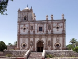
settlement of Kadakaamán and the Jesuit
Mission San Ignacio
founded in 1728 by Juan Bautista Luyando.
At San Ignacio, Baja California's arid Central Desert terrain gives way to a large grove of lush green date palms. A large spring-fed pond and small river on the outskirts of town feeds into the central plaza and village next to the eighteenth-century Jesuit mission. San Ignacio serves as the gateway to San Ignacio Lagoon
, the winter time sanctuary of the Pacific Gray Whale
.
ic soils, providing clues as to the volcanic history of this region. There are a variety of desert flora and fauna in the vicinity of San Ignacio, notably including the Elephant tree, Bursera microphylla
.
/Tijuana
border crossing, a 10-12 hour drive. Driving only during daylight hours is recommended, due to livestock that frequently cross the road at night. Mexican Federal Highway 1
is a well-maintained four-lane highway from Tijuana to Ensenada
. South of Ensenada, the highway becomes a narrow (but well-maintained) two-lane highway. There are numerous towns in which to purchase fuel, although none between El Rosario
and Guerrero Negro
, 305 km (189.5 mi) further south.
Oasis
In geography, an oasis or cienega is an isolated area of vegetation in a desert, typically surrounding a spring or similar water source...
town in the Mexican
Mexico
The United Mexican States , commonly known as Mexico , is a federal constitutional republic in North America. It is bordered on the north by the United States; on the south and west by the Pacific Ocean; on the southeast by Guatemala, Belize, and the Caribbean Sea; and on the east by the Gulf of...
state of Baja California Sur
Baja California Sur
Baja California Sur , is one of the 31 states which, with the Federal District, comprise the 32 Federal Entities of Mexico. Before becoming a state on October 8, 1974, the area was known as the South Territory of Baja California. It has an area of , or 3.57% of the land mass of Mexico and comprises...
, located between Guerrero Negro
Guerrero Negro
Guerrero Negro is the largest town located in the municipality of Mulegé in the Mexican state of Baja California Sur . It had a population of 13,054 in the 2010 census. Guerrero Negro is served by Guerrero Negro Airport.- Whale Festival :...
and Santa Rosalía
Santa Rosalía, Baja California Sur
Santa Rosalía is a city located on the Baja California peninsula, in the northern part of the Mexican state of Baja California Sur. It was named after Saint Rosalia, although the reason for the name is not quite clear since the Misión de Santa Rosalía is not located by the town, but rather in...
. The town had a 2010 census population of 667 inhabitants and grew at the site of the Cochimí
Cochimi
The Cochimí are the aboriginal inhabitants of the central part of the Baja California peninsula, from El Rosario in the north to San Javier in the south....
settlement of Kadakaamán and the Jesuit
Society of Jesus
The Society of Jesus is a Catholic male religious order that follows the teachings of the Catholic Church. The members are called Jesuits, and are also known colloquially as "God's Army" and as "The Company," these being references to founder Ignatius of Loyola's military background and a...
Mission San Ignacio
Misión San Ignacio Kadakaamán
Mission San Ignacio was founded by the Jesuit missionary Juan Bautista de Luyando in 1728 at the site of the modern town of San Ignacio, Baja California Sur, Mexico....
founded in 1728 by Juan Bautista Luyando.
At San Ignacio, Baja California's arid Central Desert terrain gives way to a large grove of lush green date palms. A large spring-fed pond and small river on the outskirts of town feeds into the central plaza and village next to the eighteenth-century Jesuit mission. San Ignacio serves as the gateway to San Ignacio Lagoon
San Ignacio Lagoon
San Ignacio Lagoon is a lagoon located Mulegé Municipality in the Mexican province of Baja California Sur, from San Ignacio, Mexico and Highway 1...
, the winter time sanctuary of the Pacific Gray Whale
Gray Whale
The gray whale, Eschrichtius robustus, is a baleen whale that migrates between feeding and breeding grounds yearly. It reaches a length of about , a weight of , and lives 50–70 years. The common name of the whale comes from the gray patches and white mottling on its dark skin. Gray whales were...
.
Natural history
The locale has certain basaltBasalt
Basalt is a common extrusive volcanic rock. It is usually grey to black and fine-grained due to rapid cooling of lava at the surface of a planet. It may be porphyritic containing larger crystals in a fine matrix, or vesicular, or frothy scoria. Unweathered basalt is black or grey...
ic soils, providing clues as to the volcanic history of this region. There are a variety of desert flora and fauna in the vicinity of San Ignacio, notably including the Elephant tree, Bursera microphylla
Bursera microphylla
Bursera microphylla, known by the common name Elephant Tree, is a tree in genus Bursera. It grows into a distinctive sculptural form, with a trunk resembling that of an elephant. The Elephant Tree is quite rare...
.
Location
San Ignacio is located approximately 856 km (531.9 mi) from the San DiegoSan Diego, California
San Diego is the eighth-largest city in the United States and second-largest city in California. The city is located on the coast of the Pacific Ocean in Southern California, immediately adjacent to the Mexican border. The birthplace of California, San Diego is known for its mild year-round...
/Tijuana
Tijuana
Tijuana is the largest city on the Baja California Peninsula and center of the Tijuana metropolitan area, part of the international San Diego–Tijuana metropolitan area. An industrial and financial center of Mexico, Tijuana exerts a strong influence on economics, education, culture, art, and politics...
border crossing, a 10-12 hour drive. Driving only during daylight hours is recommended, due to livestock that frequently cross the road at night. Mexican Federal Highway 1
Mexican Federal Highway 1
Mexican Federal Highway No. 1 follows the length of the Baja California Peninsula from Cabo San Lucas , at the southern end to Tijuana in the north...
is a well-maintained four-lane highway from Tijuana to Ensenada
Ensenada, Baja California
Ensenada is a coastal city in Mexico and the third-largest city in Baja California. It is located south of San Diego on the Baja California Peninsula. The city is locally referred to as La Cenicienta del Pacífico, or, The Cinderella of the Pacific...
. South of Ensenada, the highway becomes a narrow (but well-maintained) two-lane highway. There are numerous towns in which to purchase fuel, although none between El Rosario
El Rosario, Baja California
El Rosario is a small town on the west coast of the state of Baja California on Highway 1, 61 kmsouth of San Quintín and 119 km north of Cataviña. The census of 2010 reported a population of 1,704 inhabitants...
and Guerrero Negro
Guerrero Negro
Guerrero Negro is the largest town located in the municipality of Mulegé in the Mexican state of Baja California Sur . It had a population of 13,054 in the 2010 census. Guerrero Negro is served by Guerrero Negro Airport.- Whale Festival :...
, 305 km (189.5 mi) further south.
External links
- www.AllAboutBaja.com Learn all about San Ignacio and the magnificent Baja peninsula.
- Global Positioning SystemGlobal Positioning SystemThe Global Positioning System is a space-based global navigation satellite system that provides location and time information in all weather, anywhere on or near the Earth, where there is an unobstructed line of sight to four or more GPS satellites...
27°18′N 112°54′W - History of the Mission of San Ignacio.