

San Bernardino National Forest
Encyclopedia
San Bernardino National Forest is a federally-managed forest
covering more than 800,000 acres (3,200 km²). There are two main divisions which are the San Bernardino Mountains
on the easternmost of the Transverse Range, and the San Jacinto
and Santa Rosa Mountains
on the northernmost of the Peninsular Range. Elevations range from 2,000 to 11,499 feet (600 to 3505 m). The forest includes five wilderness areas: San Gorgonio, Cucamonga, San Jacinto, Santa Rosa and Bighorn Mountain. This National Forest is managed by the USDA Forest Service. Forest headquarters are located in the city of San Bernardino
. The Forest Supervisor is currently Jeanne Wade Evans. There are local ranger
district offices in Fontana
, Idyllwild, and Skyforest
.
Part of the 1969 musical film Paint Your Wagon
was shot here.
The west border of the Forest adjoins Angeles National Forest
and runs north-south about ten miles west of Interstate 15
. At its widest parts, the northern portion of the Forest runs about 57 mile in an east-west dimension. It runs about 24 mile in a north-south dimension. This portion of the forest encompasses the San Bernardino Mountains
. The area has a west extent west of Mount San Antonio , and Wrightwood
in San Bernardino County
. Parts of the east extent of this portion extend about ten miles east of Big Bear City
and include the San Gorgonio Wilderness
. The most southern portion is bisected by the Riverside County
line and abuts the Morongo Indian Reservation
north of Cabazon
.
At its widest point, the southern portion is about 27 mile in a north-south dimension and about 30 mile in an east-west dimension. Toro Peak, , and the Santa Rosa Indian Reservation are near the south extent. At the north is Snow Creek Village and the Morongo Indian Reservation. Out of the southern portion is carved Mount San Jacinto State Wilderness. The community of Idyllwild is surrounded by National Forest lands.
While most Forests include lumber resources, these two areas also include:
One of its best waterfalls is Bonita Falls
.
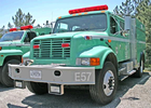 The five-member crew of Alandale Forest Fire Station's Engine 57 was killed at the Esperanza Fire
, October 26, 2006. The fire was located near Beaumont, California
in Riverside County
. Alandale station is located near the community of Idyllwild.
, Jeffrey pine
, Sugar pine
, Coulter pine
, Lodgepole pine
, Single-leaf pinyon
, and Knobcone pine
all thrive here. Other coniferous trees such as White Fir
, bigcone Douglas-fir (Pseudotsuga macrocarpa), Incense Cedar, and Western Juniper also thrive here. Canyon Live Oak, California Black Oak
, and Pacific Dogwood
are other trees that also grow here. The forest contains an estimated 87400 acres (353.7 km²) of old growth. The most common old-growth forest types are mixed conifer Coast Douglas-fir
(Pseudotsuga menziesii var. menziesii), Ponderosa Pine
(Pinus ponderosa), and White Fir
(Abies concolor) forests, Jeffrey Pine
(Pinus jeffreyi) forests, and Lodgepole Pine
(Pinus contorta) forests.
United States National Forest
National Forest is a classification of federal lands in the United States.National Forests are largely forest and woodland areas owned by the federal government and managed by the United States Forest Service, part of the United States Department of Agriculture. Land management of these areas...
covering more than 800,000 acres (3,200 km²). There are two main divisions which are the San Bernardino Mountains
San Bernardino Mountains
The San Bernardino Mountains are a short transverse mountain range north and east of San Bernardino in Southern California in the United States. The mountains run for approximately 60 miles east-west on the southern edge of the Mojave Desert in southwestern San Bernardino County, north of the...
on the easternmost of the Transverse Range, and the San Jacinto
San Jacinto Mountains
The San Jacinto Mountains are a mountain range east of Los Angeles in southern California in the United States. The mountains are named for Saint Hyacinth . The Pacific Crest Trail runs along the spine of the range.The range extends for approximately from the San Bernardino Mountains southeast to...
and Santa Rosa Mountains
Santa Rosa Mountains (California)
The Santa Rosa Mountains are a short mountain range in the Peninsular Ranges system, located east of the Los Angeles Basin and northeast of the San Diego metropolitan area of southern California, in the Southwestern United States.-Geography:...
on the northernmost of the Peninsular Range. Elevations range from 2,000 to 11,499 feet (600 to 3505 m). The forest includes five wilderness areas: San Gorgonio, Cucamonga, San Jacinto, Santa Rosa and Bighorn Mountain. This National Forest is managed by the USDA Forest Service. Forest headquarters are located in the city of San Bernardino
San Bernardino, California
San Bernardino is a city located in the Riverside-San Bernardino metropolitan area , and serves as the county seat of San Bernardino County, California, United States...
. The Forest Supervisor is currently Jeanne Wade Evans. There are local ranger
National Park Ranger
National Park Service Rangers are among the uniformed employees charged with protecting and preserving areas set aside in the National Park System by the United States Congress and/or the President of the United States...
district offices in Fontana
Fontana, California
Fontana is a city of 196,069 residents in San Bernardino County, California. Founded in 1913, it remained essentially rural until World War II, when entrepreneur Henry J. Kaiser built a large steel mill in the area...
, Idyllwild, and Skyforest
Skyforest, California
Skyforest is an unincorporated community in San Bernardino County, California, United States. Skyforest is located on California State Route 18 southeast of Lake Arrowhead. Skyforest has a post office with ZIP code 92385, which opened in 1928....
.
Part of the 1969 musical film Paint Your Wagon
Paint Your Wagon (film)
Paint Your Wagon is a 1969 American musical film starring Lee Marvin and Clint Eastwood. The movie was adapted by Paddy Chayefsky from the 1951 stage musical by Lerner and Loewe, set in a mining camp in Gold Rush-era California.-Plot:...
was shot here.
Geography
According to US Geological Survey maps of the Forest, it consists of two large areas or tracts: a northern and southern portion.The west border of the Forest adjoins Angeles National Forest
Angeles National Forest
The Angeles National Forest of the U.S. National Forest Service is located in the San Gabriel Mountains of Los Angeles County, southern California. It was established on July 1, 1908, incorporating the first San Bernardino National Forest and parts of the former Santa Barbara and San Gabriel...
and runs north-south about ten miles west of Interstate 15
Interstate 15 in California
In the U.S. state of California, Interstate 15 is a major north–south route through the San Bernardino, Riverside, and San Diego Counties, and it has a length of in the state. It is a major thoroughfare for traffic between Southern California and Las Vegas, Nevada, as well as points beyond...
. At its widest parts, the northern portion of the Forest runs about 57 mile in an east-west dimension. It runs about 24 mile in a north-south dimension. This portion of the forest encompasses the San Bernardino Mountains
San Bernardino Mountains
The San Bernardino Mountains are a short transverse mountain range north and east of San Bernardino in Southern California in the United States. The mountains run for approximately 60 miles east-west on the southern edge of the Mojave Desert in southwestern San Bernardino County, north of the...
. The area has a west extent west of Mount San Antonio , and Wrightwood
Wrightwood, California
Wrightwood is a census-designated place in San Bernardino County, California. It sits at an elevation of . The population was 4,525 at the 2010 census.-History:...
in San Bernardino County
San Bernardino County, California
San Bernardino County is a county in the U.S. state of California. As of the 2010 census, the population was 2,035,210, up from 1,709,434 as of the 2000 census...
. Parts of the east extent of this portion extend about ten miles east of Big Bear City
Big Bear City, California
Big Bear City is an unincorporated, census-designated place in San Bernardino County, California immediately east of Big Bear Lake. The population was 12,304 at the 2010 census, up from 5,779 at the 2000 census...
and include the San Gorgonio Wilderness
San Gorgonio Wilderness
San Gorgonio Wilderness is located in the San Bernardino Mountains, north of Morongo Valley and approximately northwest of Palm Springs, California...
. The most southern portion is bisected by the Riverside County
Riverside County, California
Riverside County is a county in the U.S. state of California. One of 58 California counties, it covers in the southern part of the state, and stretches from Orange County to the Colorado River, which forms the state border with Arizona. The county derives its name from the city of Riverside,...
line and abuts the Morongo Indian Reservation
Cahuilla
The Cahuilla, Iviatim in their own language, are Indians with a common culture whose ancestors inhabited inland areas of southern California 2,000 years ago. Their original territory included an area of about . The traditional Cahuilla territory was near the geographic center of Southern California...
north of Cabazon
Cabazon, California
Cabazon is a census-designated place in Riverside County, California, United States. The population was 2,535 at the 2010 census, up from 2,229 at the 2000 census.-History:...
.
At its widest point, the southern portion is about 27 mile in a north-south dimension and about 30 mile in an east-west dimension. Toro Peak, , and the Santa Rosa Indian Reservation are near the south extent. At the north is Snow Creek Village and the Morongo Indian Reservation. Out of the southern portion is carved Mount San Jacinto State Wilderness. The community of Idyllwild is surrounded by National Forest lands.
While most Forests include lumber resources, these two areas also include:
- Residential communities and resorts.
- Indian resources such as historically-important caves and pictographs.
- A University of CaliforniaUniversity of CaliforniaThe University of California is a public university system in the U.S. state of California. Under the California Master Plan for Higher Education, the University of California is a part of the state's three-tier public higher education system, which also includes the California State University...
research station.
One of its best waterfalls is Bonita Falls
Bonita Falls
Bonita Falls is a set of waterfalls in the San Bernardino National Forest, formed by Bonita Creek, that is said to be 370 or 400 feet in height, but possibly up to 495 feet high because of two undocumented drops in the canyon above. It is the second tallest in the national forest, being surpassed...
.
Esperanza Fire
The Esperanza Fire was a wind-driven, arson-caused wildfire that was started in a river wash near Cabazon, California, west of Palm Springs, California. By Sunday, October 29, 2006, it had burned over 61 square miles and was 85% contained...
, October 26, 2006. The fire was located near Beaumont, California
Beaumont, California
Beaumont is a city in Riverside County, California, United States in the Greater Los Angeles area.Now a growing, community planned city, the population was 36,877 at the 2010 census, and expected to be up to 125,000 projected by 2040, making Beaumont as California's next, newest fastest-growing...
in Riverside County
Riverside County, California
Riverside County is a county in the U.S. state of California. One of 58 California counties, it covers in the southern part of the state, and stretches from Orange County to the Colorado River, which forms the state border with Arizona. The county derives its name from the city of Riverside,...
. Alandale station is located near the community of Idyllwild.
Firefighting aircraft operations
As of 2001, eight Air Tactical Group Supervisors (ATGSs) work out of the Forest Supervisor's Office in San Bernardino. This position requires completion of an 80 hour CDF/Forest Service attack management course. A Helicopter Coordinator (J-374) course is recommended.Vegetation
There are many different species of trees, many coniferous, that grow in the mountains. Pines such as Ponderosa pinePonderosa Pine
Pinus ponderosa, commonly known as the Ponderosa Pine, Bull Pine, Blackjack Pine, or Western Yellow Pine, is a widespread and variable pine native to western North America. It was first described by David Douglas in 1826, from eastern Washington near present-day Spokane...
, Jeffrey pine
Jeffrey Pine
The Jeffrey Pine, Pinus jeffreyi, named in honor of its botanist documenter John Jeffrey, is a North American pine related to Ponderosa Pine.-Distribution and habitat:...
, Sugar pine
Sugar Pine
Pinus lambertiana, commonly known as the sugar pine or sugar cone pine, is the tallest and most massive pine, with the longest cones of any conifer...
, Coulter pine
Coulter Pine
The Coulter Pine or Big-cone Pine is a native of the coastal mountains of southern California and northern Baja California . Isolated groves are found as far north as the San Francisco Bay Area in Mt. Diablo State Park and Black Diamond Mines Regional Preserve...
, Lodgepole pine
Lodgepole Pine
Lodgepole Pine, Pinus contorta, also known as Shore Pine, is a common tree in western North America. Like all pines, it is evergreen.-Subspecies:...
, Single-leaf pinyon
Single-leaf Pinyon
The Single-leaf Pinyon, ', is a pine in the pinyon pine group, native to the United States and northwest Mexico. The range is in southernmost Idaho, western Utah, Arizona, southwest New Mexico, Nevada, eastern and southern California and northern Baja California.It occurs at moderate altitudes from...
, and Knobcone pine
Knobcone Pine
The Knobcone Pine, Pinus attenuata, is a tree that grows in mild climates on poor soils. It ranges from the mountains of southern Oregon to Baja California with the greatest concentration in northern California and the Oregon-California border....
all thrive here. Other coniferous trees such as White Fir
White Fir
White Fir is a fir native to the mountains of western North America, occurring at altitudes of 900-3,400 m. It is a medium to large evergreen coniferous tree growing to 25–60 m tall and with a trunk diameter of up to 2 m . It is popular as an ornamental landscaping tree and as a Christmas Tree...
, bigcone Douglas-fir (Pseudotsuga macrocarpa), Incense Cedar, and Western Juniper also thrive here. Canyon Live Oak, California Black Oak
California Black Oak
Quercus kelloggii, the California Black Oak, also known as simply Black Oak, or Kellogg Oak, is an oak in the red oak section , native to western North America...
, and Pacific Dogwood
Pacific Dogwood
The Pacific Dogwood, Cornus nuttallii , is a species of dogwood native to western North America from lowlands of southern British Columbia to mountains of southern California. An inland population occurs in central Idaho. Cultivated examples are found as far north as Haida Gwaii...
are other trees that also grow here. The forest contains an estimated 87400 acres (353.7 km²) of old growth. The most common old-growth forest types are mixed conifer Coast Douglas-fir
Coast Douglas-fir
Pseudotsuga menziesii, known as Douglas-fir, Oregon Pine, or Douglas spruce, is an evergreen conifer species native to western North America. Its variety Pseudotsuga menziesii var. menziesii, also known as coast Douglas-fir grows in the coastal regions, from west-central British Columbia, Canada...
(Pseudotsuga menziesii var. menziesii), Ponderosa Pine
Ponderosa Pine
Pinus ponderosa, commonly known as the Ponderosa Pine, Bull Pine, Blackjack Pine, or Western Yellow Pine, is a widespread and variable pine native to western North America. It was first described by David Douglas in 1826, from eastern Washington near present-day Spokane...
(Pinus ponderosa), and White Fir
White Fir
White Fir is a fir native to the mountains of western North America, occurring at altitudes of 900-3,400 m. It is a medium to large evergreen coniferous tree growing to 25–60 m tall and with a trunk diameter of up to 2 m . It is popular as an ornamental landscaping tree and as a Christmas Tree...
(Abies concolor) forests, Jeffrey Pine
Jeffrey Pine
The Jeffrey Pine, Pinus jeffreyi, named in honor of its botanist documenter John Jeffrey, is a North American pine related to Ponderosa Pine.-Distribution and habitat:...
(Pinus jeffreyi) forests, and Lodgepole Pine
Lodgepole Pine
Lodgepole Pine, Pinus contorta, also known as Shore Pine, is a common tree in western North America. Like all pines, it is evergreen.-Subspecies:...
(Pinus contorta) forests.